Traveling with a car navigator: big screen to the masses
 Back in 2001, I happened to develop a navigation system for Windows Mobile. In those days it was an exotic and expensive thing, even for Moscow. The CCP was rapidly improving, and they were still only waiting for the peak of popularity (remember the well-known iPAQ). We were developing on the weighty “bricks” of the Casio E125. Civilian GPS receivers had draconian limitations on accuracy - an error of at least 30 meters, which made the task of tracking along the route very nontrivial. Due to severe restrictions on the amount of expensive flash memory, the map of Moscow with each house and with all interchanges and lanes occupied us 8 MB in its own format, the whole Moscow region - 30 MB. Unfortunately, the business then had to freeze due to overvalued demand. I think that all the difficulties of that period deserve a separate article.
But as time went on, the population grew richer, technologies became cheaper, and now, 10 years later, a long-distance car trip without a navigator was, rather, an exception.
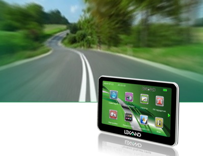
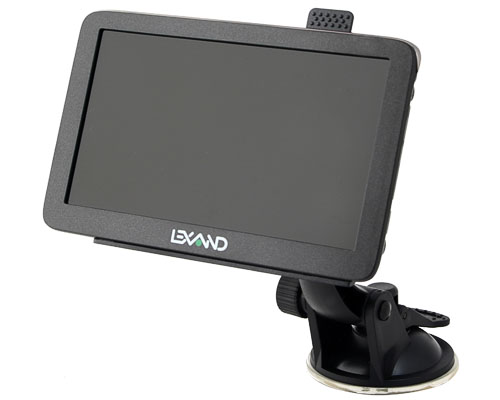
Gathering by car from Moscow to the Crimea, I was lucky enough to get an impressive size navigator Lexand ST-610 and was very impatient to look at the results of a decade of development.
')
Preparing the navigator on the road took relatively little time. Over the past year, I have fluently tried several navigation programs on my PDA, having traveled with them around Moscow, and by the time of the trip I finally stopped at iGo 8. There is, of course, a large proportion of subjectivity, but there are also objective criteria: other tested systems hung several times the most inopportune moment. With iGo this has never happened. Naturally, everything is being improved, and, most likely, more recent versions work more stable, or I had some specific problem. But I preferred the proven option, so as not to risk remaining without navigating somewhere off the beaten path. But let's get everything in order.
Equipment
Quite standard for today:
- actually, the navigator in a stylish slim case
- holder on the car window
- car charger
- USB cable (sync + charge)
- stylus
- soft case
- leadership
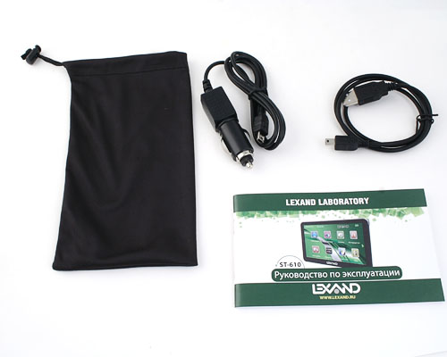
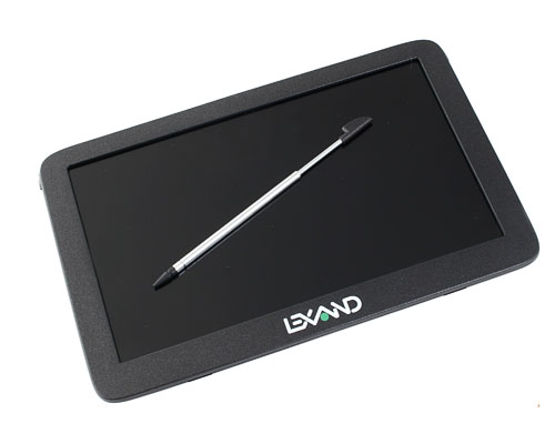
Nothing more, except, perhaps, the stylus. With such a large screen, it may occasionally come in handy for resetting the device. Later it turned out that this is not quite the case, as discussed below. By the way, finding it was not easy: for the sake of ergonomics, it almost merges with the rounded back wall of the case.
But what may be in demand when using the navigator as a media player is an autonomous network charger, which is proposed to be purchased separately. However, all the same, the main function is navigation in the car, therefore it is unlikely that this minus can be considered serious.
Now let's look at the characteristics of the device
Screen
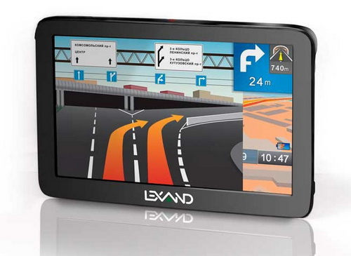
This, of course, is what attracts in the first place. Touch resistive TFT-screen on the TN-matrix, a diagonal of 6 inches, QVGA resolution 480 * 272, 65,000 colors.
At first it seemed to me that the resolution with such a diagonal was not enough, but then it became clear that for navigation it was quite enough. It is very likely that the dynamic drawing of a map on a 500 MHz processor will slow down at higher resolutions. Although, there may be a simple desire to save. There is still unconfirmed information that the next batch of ST-610 will be with other technical characteristics, the changes should just concern the resolution and screen qualities.
Declared finger-oriented interface. Why "declared"? Because on a resistive matrix, pressing with a finger pad does not always work - you have to use your fingernail or stylus, which is not very convenient and dangerous for the screen. Only scrolling the map was possible with the finger plane without any problems.
I also didn’t like that with every touch, very noticeable “waves” scatter across the screen, like on desktop, non-touch, monitors. On ordinary PDAs and communicators there is no such phenomenon. I am not very deeply familiar with sensory technologies, but I suspect that these are also features of this type of cheap matrix.
The screen does not glare. However, the viewing angles, like all TN-matrices, are small, especially vertically. This is not so important for the driver, but inconvenient for the "navigator."
And I would still think about some kind of protection - the screen is very easy to damage if the device falls on something sharp and hard.
In general, on the big screen it is much more convenient to scroll the map behind the wheel, the zoom is not so often needed - all the inscriptions and objects are perfectly visible. This is an indisputable advantage.
Body size, weight
128x82x12.7 mm, 195 g. The body is stylish, without backlash and creaking. It has a record for devices with such a diagonal thickness. Low weight is also important - less likely that the navigator accidentally fall off on the go.


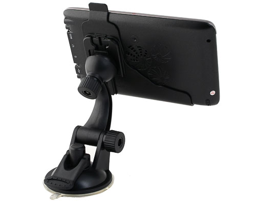
Car mount
I really liked it (see photo above). Made very high quality. Both degrees of freedom are securely fixed in any position. Fastens easily and quickly, without effort. When driving, the device does not hang out and practically does not tremble. The suction cup from the glass never fell off by itself, even with a strong heat in the cabin. But here, for example, I tried to stick it on plastic in the office — it peeled off after a while. Generally speaking, in addition to the sucker, it is high time to come up with a more reliable mount, for example, a screw. In some cars it can be used, for example, on the ventilation grille. Maybe a certain standard is needed - then the situation will improve. But automakers, unfortunately, are very conservative.
operating system
Microsoft WinCE.NET 6.0. Given that most of the most popular navigation software exists in the version for Windows CE, this choice is quite natural. I do not know how the situation will change after the release of Windows Phone 7 - we'll see.
On the navigator pre-installed shell of its own production, which is below.
Memory
RAM (SDRAM) 64MB. According to some reviews, this volume may not be enough for heavy navigation software, but I had no problems. Real problems and freezes happen on 32 MB with programs such as iGo. There even does not always help editing the notorious sys.txt. In principle, it would not hurt another 64 MB to guarantee to avoid any problems in the near future. But it seems they decided to save money here.
ROM (NAND Flash) 4Gb. This volume allows you to record several navigation programs with maps, but probably it is preferable to use an external flash drive for this: honestly, I am not sure that the contents of the ROM will be saved in case of hard reset. In my version, 1 GB of ROM was used on the device. Of these, about 50 MB of service files and 950 MB are Navitel Navigator with maps of Russia (1 and 10 km). There is also a Russian instruction in PDF.
MicroSD expansion slot (support for SDHC cards up to 32GB). Here the possibilities are endless - you can take with you every conceivable navigation system with all the available maps. It may well be that some particular program works better in different countries.
CPU
SiRFatlasIV, ARM1136JF-S, 500Mhz. This is a new processor, made on 65 nm technology. Probably due to this, the device is poorly heated. The processor is fast enough - the navigation system does not slow down.
GPS chipset
SiRF GRF3i +, 64 channels. Very stable reception, never lost satellites, you can safely hold the navigator in your hands while sitting in the car. The first start lasts about 2 minutes. I liked that the navigator very accurately determines the position. If the information is correct, the accuracy of the receiver is about 3 meters, which is enough for confident determination of not only the road, but also the lane. I remember the torment we had with the old receivers “coarse” up to 30 meters. The system behaved especially badly when driving through difficult interchanges or contiguous streets, and no algorithms could fix this. Now there is no such problem in principle.
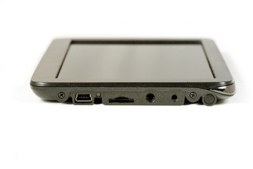
Computer connection
USB 2.0 miniUSB cable included. It can work in two modes: regular flash-disk or Microsoft ActiveSync. The choice is made through the dialog that appears when the USB cable is connected.
Data copying is relatively slow - about 1 MB per second. But I do not think this is a big problem, because navigation software does not change too often.
I had problems in flash drive mode: the navigator is recognized as an unknown device. ActiveSync mode saved the situation. Perhaps the reason for the raw firmware, because, as far as I heard, Lexand is usually fine with this. Naturally, when using a microSD card bundled with a card reader, there will be no such problems.
Nutrition
Built-in lithium-ion battery with a capacity of 850 mAh, operating time without recharging with a minimum illumination - up to 2.5 hours, with a maximum - up to 1 hour, time to fully charge the battery - 2-3 hours. It really is very small. Those. in the car it’s all the same because The device is usually powered by a cigarette lighter, but as a media player or as a pedestrian navigator it is almost impossible to use it. Even in a car in a long road, sometimes there is a need to recharge the phone, and during this time the navigator easily sits down.
In addition, for some reason, the battery is not always charged. Whether the unreliable USB connector is to blame, or my cigarette lighter - I still do not understand. It is even possible that the matter is in the firmware, which does not always include a charge. Anyway, a couple of times he turned off while on the run from full discharge and after re-switching on successfully started charging. I want to remind that you can insert the cigarette lighter wire only when the engine is running, because a voltage surge during ignition can damage the device.
Additional functions
FM transmitter. Allows you to output sound from the navigator (voice prompts, music, sound from video) to the speakers of the in-car audio system using the FM signal. On a trip I could not configure. Later I read that for this the transmitter requires a connected USB cable, which works as an antenna. But, in principle, the volume of the built-in speaker is enough and so. In addition, on long journeys you usually listen to music on the radio, and in the case of sound output from the navigator this will not be possible. Now, if there was an opportunity to mix the sound in the radio with the sound of the navigator, then this function would be really useful. According to reviews, the transmitter broadcasts to a distance of 7 meters and is even able to drown out the radio in a nearby car.
Multimedia applications and utilities: video, audio, photo, text, games, calendar, notes, calculator. All this standard set is present in most navigators, but rather for a tick. I did not even try. Those who used complained that the films should be clamped to a lower resolution, there was no support for some music formats, etc. This is despite the fact that under Windows CE there are much more functional media players than the one built into the navigator. The reader of text files opens only txt, of course, only in one encoding. It may be convenient to record in the text files information about the route, description of the route, motels, campgrounds, etc. The image viewer, judging by the review of the st-570 model, does not show pictures larger than 4 MB in size.

2.5mm stereo headphone jack (not included). Also, rather, for a tick because of the difficulty of using the navigator as a player. The device does not have a hardware volume control, everything is done from the menu, which is not always convenient, especially when you need to lower the volume of voice prompts on the go if someone from the passengers falls asleep.
Lexand navigators are imputed to the lack of a Bluetooth module, which is why it is impossible to get information about traffic jams via GPRS. However, the company is preparing models with a SIM card, so the problem will be solved soon.
The device interface can be customized to your liking: using any graphic files to set the desktop background, customize your screensaver. On the flash drive for these purposes, I found the logos of the main car brands, which is very nice - it will look like full-time navigation.
The rest of the navigator is not overloaded with functionality, like larger models. After all, it must perform the main function, and the rest is much less important.
Navigation software
The main advantage of Lexand - the ability to run any navigation software. It is enough to specify the path to the executable file.

In Russia, they are equipped with one of three navigation systems:
- Navitel Navigator: detailed maps of a large number of Russian regions, detailed maps of regional centers with targeted plans
- ProCity: highly detailed maps of Russia of its own production, emulation of road junctions, prompting mode when driving along multi-lane highways
- SitiGID: a recognized leader in the field of navigation in St. Petersburg and the north-western region of Russia.
However, for an international trip, I preferred iGo, which I launched without any problems by writing to the internal flash memory.
A few words about iGo. This is an elaborate system. Anything you might need on the go is available on the main screen. There are 3 modes of viewing the map: 3D, flat, oriented to the north and oriented in the direction of movement - for whom it is convenient. The screen displays the speed, the predicted travel time (by the way, amazingly accurate!), The distance to the nearest junction. The system warns about speeding (the threshold is configured) - I was constantly rescued. On the additional screen, you can watch a variety of parameters: distance traveled, maximum speed, altitude, direction of travel, etc. The program supports skins and offers several options for voice acting. It is very convenient that the route can be laid between different maps, say, Russia and Ukraine. The transition is invisible to the user. Voice prompts are very high quality and minimum required. When leaving the route, he re-creates a new one without any questions. If he does not know the road (for example, the new bypass), then he is just silent, until we reach the track she knows. There are hot buttons for switching viewing modes, searching for user points (the base is very large and constantly replenished), a button for searching a detour. The map display is very well done - when approaching the decoupling, the detailing becomes very detailed, and when we go to a long section without congresses, the map is removed to improve the view. There are many more pleasant things, but all this deserves a separate story.
I just want to say that iGo never hovered over all 3 or more thousands of kilometers of the way and walked us along the route perfectly, being confused only once on the new Kharkov-Dnepropetrovsk highway, where we were following the signs. I think that the route has already been added on new maps.
In all navigation programs, you should not blindly believe the paved route, especially in large cities, otherwise the risk of entering a dead traffic jam at rush hour is quite large. For this, by the way, there are different modes of route calculation - the shortest, optimal, fast.
findings
We can say that we face the correct Chinese device. Positive impressions significantly exceed small defects. The current minimum price in Svyaznoy is 6990 rubles. In other stores for some reason more expensive - from 8400 rubles. Honestly, it's expensive, considering that the 610th model differs from its younger counterparts only in the screen diagonal. You can, of course, order in China 2 times cheaper and without navigation software, but, remembering about our mail, the desire immediately disappears.
For those who read only the introduction and conclusion, a list of pros and cons.
Advantages :
- big screen
- modern processor and GPS receiver
- the ability to run any navigation program
- FM transmitter
- stylish very slim body
- great car mount
Disadvantages :
- raw firmware (problems with USB connection)
- using your fingers is not very convenient due to the type of touch screen
- no mains charging included
- the screen is not protected by anything
- frankly weak battery
- the lack of any way to communicate with the phone
- relatively expensive
In general, there is something to improve, but I do not see fatal flaws. Compared with what was at the dawn of the era of navigators - then this could only dream of.
Source: https://habr.com/ru/post/95867/
All Articles