Overview of GPS Tracks Storage Services
I decided to find a service for myself that allows you to store GPS tracks for trips and walks, simply draw future travel routes on a map and share them with friends. Of the requirements - linking the photo to the route, various statistics on the trip, the ability to draw routes in the browser. Be sure to download tracks in GPX or NMEA format, a nice bonus would be to have an application for the iPhone.
After going through a lot of similar services - I decided to single out three (good number, yes) of the most interesting and multifunctional ones, and I want to bring an overview of these services to your attention.
Everytrail.com
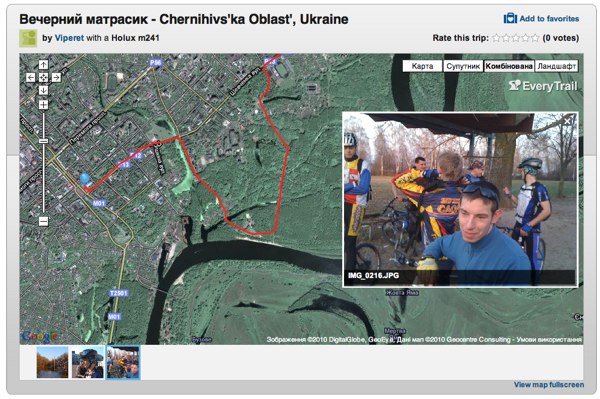
The site is interesting because Flash is used to view the route - it displays a Google map with a route, height and speed graphs, as well as a slideshow of photos and videos attached to the route. Thanks to the Flash map is displayed very quickly, when you change the scale, the route line is shown constantly and does not disappear while the map is loaded, unlike the JS version of Google Maps used on other sites. Among the shortcomings - you can not use the mouse wheel to zoom, as well as due to the use of the Flash route can not be viewed on browsers that do not support it (iPhone, iPad), although for them in the AppStore there is an application of the same name EveryTrail with which you can record routes , view previously recorded routes.
The route to the site can be downloaded either using branded software for popular mobile platforms (iPhone | Android | Windows Mobile | Blackberry) or simply from a computer to download a track file recorded by any GPS navigator or logger - check downloads in GPX, NMEA formats. Another track you can simply draw directly in the browser - convenient if you are just planning a trip and want to show the route to his comrades. The site allows you to combine tracks made for example on different days of the trip. There is also a function of “trimming” tracks, but I didn’t work out how it works.
The service allows you to attach photos taken during the trip to the track, so that the point where the photo was taken will be displayed on the map. It supports uploading photos from a computer (done using Flash, “drops” Opera browser on my computer), as well as importing photos from Flickr, Picasa, or videos from Youtube. Photos on the track can be placed manually or automatically - just specify the time difference between the camera clock and GPS (if it exists) or simply manually set one photo (for example, the first one, at the starting point) and the site will determine the time difference automatically.
GPSLogLabs.com
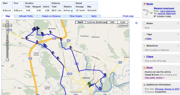
An excellent site designed to monitor their sporting achievements, store training routes and travel. Displays a lot of various statistical information about the route and shows a huge number of graphs. The site interface is made using JS, all graphs can be enlarged and scrolled. The peculiarity of the service is that it has a very good track editor, they can be divided, combined, as well as impose various filters.
The service provides excellent tools for analyzing trainings or travels, for example, you can see how many kilometers you run / hit in each month, there are even comic reports - for example, it shows me that my distance traveled 39.3 km - this is 93% of marathon distances, and the total climb for this trip 1.0 km is 12% of the height of Mount Everest.
Among the disadvantages of the service is a rather complicated interface, the inability to upload photos related to the track and the inability to download the track to anyone other than the user who created it.
')
GPSies.com
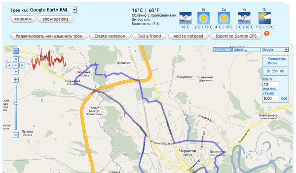
Probably the most famous GPS tracker storage service. Allows you to view the downloaded track not only on Google maps, like most services, but also on OSM, Yahoo and Microsoft maps - which, however, is irrelevant for the CIS. From the graphs, the service shows only the height graph - however, it is also the most convenient to use among the sites reviewed - if you hover the mouse on the graph - not only the numerical value of the altitude at this moment is shown, but also the corresponding point on the track. You can attach photos downloaded from a computer or a Picasa album to the track, as well as Youtube videos.
Of the minuses of the service can be noted just a wild amount of advertising.
Added at the request of TarzanASG : If you were driving along the road while recording a track, and this road is not on the OpenStreetMap map (OSM), you can help the community by uploading your track to the OSM website. Download instructions included. Also on GPSies.com there is a function of fast loading of any track on OSM, for this it is enough to click the “Submit to Openstreetmap” button on the track preview page.
findings
For myself, I did not choose the definitive leader among the storage services of tracks, now I hesitate between everytrail.com and gpsloglabs.com. The first one attracts the user-friendly interface of the site and a nice program for the iPhone, the second one attracts a large amount of track statistics. GPSies.com is also nothing, but because of the abundance of advertising to use it, and even more so to give someone a link to this site absolutely do not want. If anyone knows the track storage services that are still worth attention, please tell me.
Source: https://habr.com/ru/post/90909/
All Articles