About the accuracy of maps, Google, NAVTEQ and "freebies"
Steve Kost, who in 2004 began the project to create open road maps OpenStreetMap published an interesting post on his blog that the project won again in the card accuracy test among market giants held by telemapics.com. Here is what MDob writes on its blog:
Although there is no mention of OSM cards in the article, Steve says that this time free cartography and the OpenStreetMap project have won, because this interchange is drawn correctly in it and it is possible to build routes using these maps using CloudMade services .
On the accuracy of maps, Google, NAVTEQ and "freebies."
To my last entry, a message was left by the reader, who raises the topic of the actual cost of “free” navigation and its quality, as well as the fate of the paid analogs. Since then, Nokia has announced that their NAVTEQ cards are also becoming free on new models of smartphones.
I think there are at least 2 strategies here. First, Nokia may try to protect its position in the market for phone suppliers in the US and Europe by offering competitive or superior Google in terms of the quality of its map data services. The second strategy may be an attempt to expand its dominance in markets in areas where Google currently has no maps and where there is data from Nokia NAVTEQ. On the other hand, Google can, through user input via Google Map Maker, create pedestrian navigation in more countries than NAVTEQ has maps for cars. This can occur in countries where road transport is underdeveloped.
However, as we concluded earlier, in geographical markets, the key advantage may be not so much the cartographic data or the navigation services themselves, as the support of this data in “proximity search” and, possibly, in social networks, and in perspective and geography. dependent advertising.
In an interview with Kevin Dennehy at GPS World, I said that "... Google does not compete directly with TeleNav, TeleAtlas, MapQuest and anyone who is not in the advertising business. The poor guys involved in cartography, navigation, LBS and local search are confused by the company's constant innovation Google in order to get the best advertising engine. Today, for most companies, it’s impossible to compete with Google, because Google considers its “applications” to be the only means to achieve the goal, not the main business. They earn so much money that they can afford to innovate spend 50 mil the project and “throw it out” if it doesn't work the way they want it. " I added: “Although the end user can think of Google as a convenient search service, map service, route planking and other information services, Google thinks of itself as an advertising engine that has the ability to deliver advertising to users wherever possible.” .
If my vision of this topic has any significance, then I would like to highlight two questions. First: “What level of accuracy or accuracy is required by Google to support their advertising business?”, The following: “What impact will Google’s data have on the rest of the industry?” The most disturbing aspect of the latter question, at least, I think so, is the difficulty of increasing credibility cartographic databases, when increasing costs of data collection occur, in a market that should provide free maps and route routing. So let's talk about the quality of the data released by Google and move on to the topic next week.
As noted earlier in this blog, Google rejects TeleAtlas data because they were unhappy with the accuracy of the data and are confident that they can do better. From this we can begin to judge the goal of Google in terms of the accuracy of the maps. Although this is just the beginning of the game, Google does not provide data that is more accurate than the data of its competitors and in most cases does not provide geographic data of such accuracy as its competitors. Google seems to have adopted its “free” model, based on the opinion: “We provide a base map and support it, but you, Mr. or Mrs. user, need to correct something that is not suitable for you.” Is it possible that this will become the initial level of standards in the cartographic industry? Of course, this means that you can provide information on errors on the map, but let's discuss it another time.
Despite the fact that Google created an engine for mapping, which had to solve problems with the accuracy and reliability of maps, the creation of such an engine is not a guarantee of its successful integration into the problem solving system, nor the ability of the Google team to manage a workable map updating system and get the desired result level.
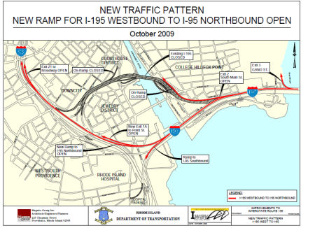
Some bugs in the google map database are unforgivable. For example, in his maps there is no additional connection of the I-195 / I-95 routes in Providence, despite the fact that in their Street View there are photos of the new junction (I think that they simply did not know that they were driving along the new section of the I- 195). If you want to read about it in more detail, then look at the entry on the website of the Transportation Department (TD) of Rhode Island. The department’s recording ends with the words “note that these changes to the traffic pattern will not be included in online mapping programs and GPS navigation systems.” Thanks to Jim for the link.
According to the TD, the situation on the ground is as follows. At least since October. You can download a PDF of this image from TD Rhode Island, which can be enlarged directly to the desired fragment.
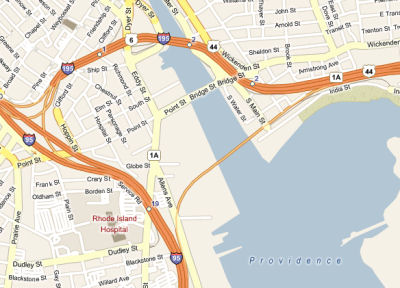
Of course, if you open a Bing card, you will see:
And if you look at the map from Navteq (they still stand)
And google
Oh! If this is the best and free data, then it seems they will return the times with paper maps. Perhaps this is an alternative. Let's talk about it next time.


Although there is no mention of OSM cards in the article, Steve says that this time free cartography and the OpenStreetMap project have won, because this interchange is drawn correctly in it and it is possible to build routes using these maps using CloudMade services .
')
Source: https://habr.com/ru/post/84950/
All Articles