About progorod
There is such a navigation project as Progorod . He is very young - the official launch was in November last year, with the first beta testing only six months earlier. However, if we take into account the seven million dollars (!) Spent on the creation of this project, the conclusion involuntarily suggests that they did not do it in the garage or on the knee. " 33,000 cities and towns, 120,000 points of interest, 800,000 kilometers of roads " - after all, the figures deserve respect and in every way have the beginning of the test.

But seriously, the navigator advised to try one friend of the girl, who said in one conversation that “ he is no worse than Navitel ” - to some extent this also hurt me)
And I decided to see what they have for the city for this)
')
It all started with the download of the software itself. This is almost 400MB from the manufacturer's website. There are versions for navigators (WinCE 5.0 and higher), communicators (WM not lower than 5.0) and phones (J2ME).
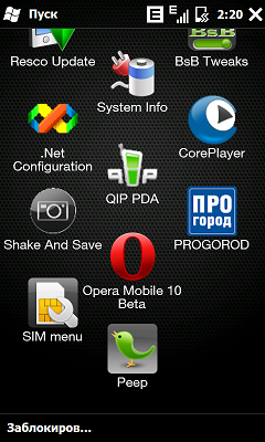
Naturally, I chose a middle ground - for my HTC HD2. But the fact that there is a software version specifically for navigators is good - in case you like it, you can pour it into the navigator (it has a larger screen diagonal + there is a mount on the glass).
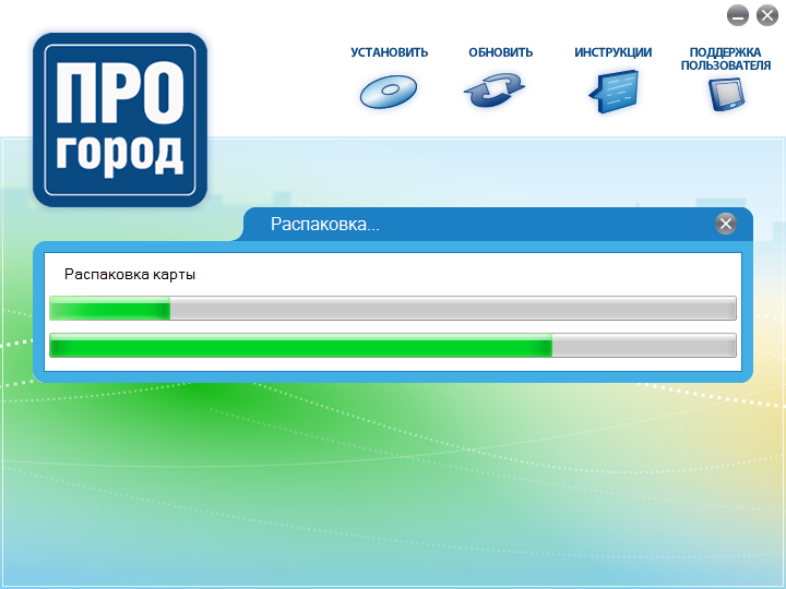
There are no problems with the installation - it can be done both from a computer and immediately on a PDA. A minute later, a new icon appears in the launch with a normal resolution - tadam.
Starting in 4 seconds is a promising start. I turn off and look at the task manager - I only missed 10 megabytes.
Large buttons-icons and a very nice interface as a whole - what is needed during the road and what is already there in many places)

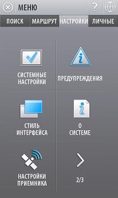
So go ahead. In the main menu there are 4 tabs - “Search”, “Route”, “Settings” and “Personal” - on each tab there are several pages of functions (6 per page).
It can be different:
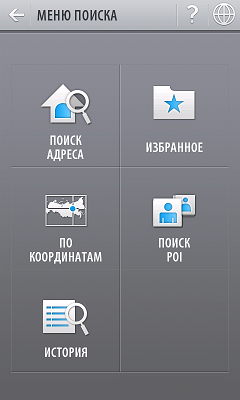
- Quick search . It is carried out at the addresses, points of interest of the POI, as well as metro stations without selection by region or locality;
- Address search . Hierarchical search by address is carried out taking into account the Russian specificity of addressing (corpus, structure, ownership, etc.);
- Search points of interest POI by address . You can select the POI category of interest, or search in all (sub) categories and then select from the list of obtained results.
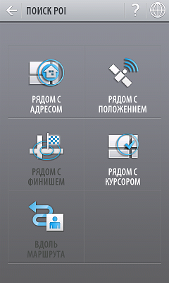
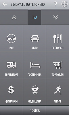
The search is carried out within a radius of 3 kilometers from a specific address, from a certain position, along a route or at its finish, as well as at the cursor on the map. Thematic framework - “Everything, cars, restaurant, transport, hotel, trade, finance, medicine, sport, religion, culture / entertainment, traffic police, education, facilities, home, sanatorium, veterinarian, lakes and shopping and recreation center” - IMHO, some that could be combined. Almost every category contains pages of subcategories.

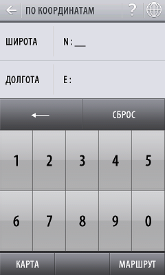
- Search by coordinates . We set the latitude and longitude and go.
Also on this tab is the "Favorites" and "History."
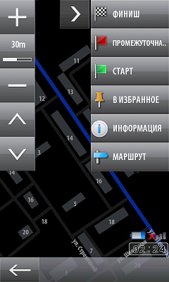
- Information about the route . Start and end points, method (short, fast or convenient), distance and time.


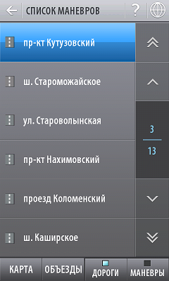
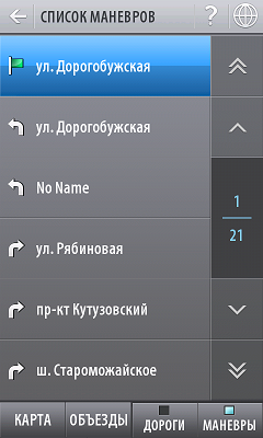
- Maneuvers . Just a list of maneuvers to be done along the route.
- Detours . After analyzing the route, the program will show a list of streets that will have to go. If you mark unnecessary streets with daws, the route will be rebuilt bypass.
- Save and load the route . In case you make a difficult route, you can save it later ... yes, no matter how strange it sounds, to load.
- Record route . In case you go somewhere at random without a route - so that you can get back or repeat the check-in later.
- Interface language . The choice is initially only Russian and English.
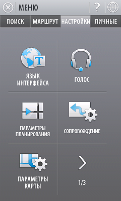
- Voice . You can choose uncle or aunt. I would like to be able to upload someone else.
- Planning options . There are three route calculation algorithms - convenient (main), short (the shortest distance between points of the route) and fast (the least number of maneuvers).

Accordingly, choosing a route, you can see all three options on the map (they will be printed in different colors and, possibly, will sometimes coincide). Very useful feature!
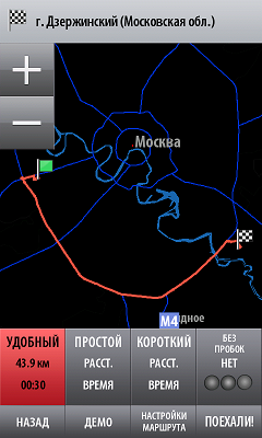
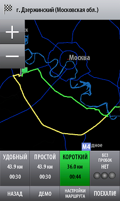
You can also choose the types of roads that will be used when laying the route - unpaved, main and paid. The function "Consider traffic jams" is still deactivated, but it seems like this year the service should be launched.
- Setting support . There are two types of scaling - depending on the speed of movement and on the distance to the next maneuver. Two types of accompaniment - the usual (in map mode) and in the "turn-by-turn" mode. With regard to escort - an indication of the remaining distance to the maneuver, as well as to the next maneuver
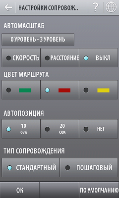
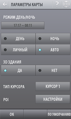
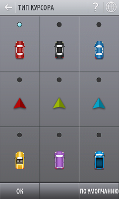
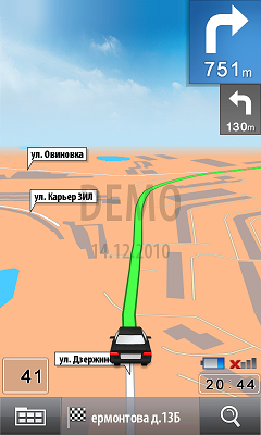
- Map options . As elsewhere there is a function of changing colors for day and night, and these time intervals can be edited. The function of 3D buildings is naturally activated! :) There are 9 types of cursor to choose from - the one that will move around the map; there must naturally be a black car, not otherwise. And at the very end - a choice of 15 categories of POI, which will be displayed on the map (you can turn off all unnecessary theaters there, leaving only the metro, fast food, ATMs and gas stations)
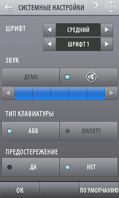
- System settings . Font size and type, sound volume, type of keyboard for input (ABC or QWERTY)
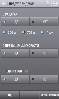
- Warnings . Almost everywhere there is a warning function for suddenly approaching radars. Here you can specify three distances (300, 700 and 1000m), to which a warning will be heard. You can set all three distances. Well, if you exceed the speed - also expressed.
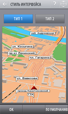
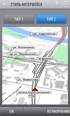
- Interface style . Initially, only two types are available (both very successful), but apparently, you can download additional themes from Ineta.
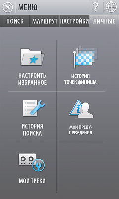
Here is the favorites, the history of the finish points, the search history, “my warnings” and “my tracks”.
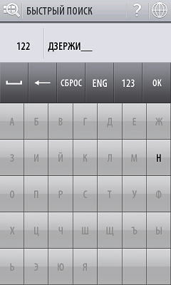
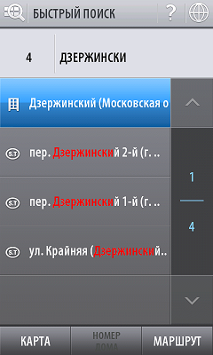
First of all, I wanted to check the accuracy of the map using the example of my city - something, and I know him well. A country is available - Russia, in it I choose a region - the Moscow region (there are 32 regions in total). Then I enter the first letters of my city (5,000 cities in total are available) - located. Further the street and the house.
The map shown is more than accurate - although I was not surprised) The errors were only on the old iGo, where the buildings with the letter names of the buildings were incorrectly signed and dirt roads were run where it was impossible to drive on the tank). All the houses have been signed, there are internal courtyards (if you can call them that), everything is great and more than true.
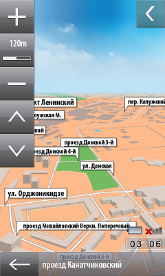
But the most pleasant thing happened when I pressed the angle change button - all the houses became pseudo-voluminous! Well, or as they call it, 2.5D. The height of the buildings is approximately proportional to their real height, and all the signatures turn into pretty balloons. This has already happened somewhere, but I really liked the implementation in the city.
Why three-dimensional houses? I agree that this will certainly load the device more, but in this case it becomes even faster and easier to navigate the terrain!
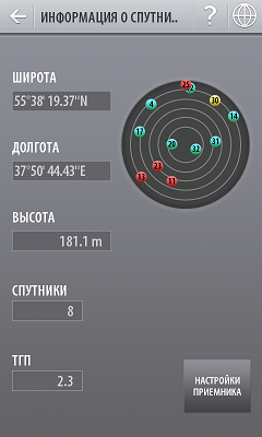
A day later, I tried to ride on the navigator, but I did not go to the center. Satellites are caught stably and without problems.
In principle, more than you can drive - the navigator does an excellent job with its work ... But I didn’t like some nuances.
For example, when I turned around and turned on, the navigator showed that I was just driving around a turn ... and after a moment, with a jerk, it showed the way where I was going. Such a delay is unlikely for anyone to like (and if the speed is even higher, the difference will become much more noticeable), although I do not rule out that this may be due to high cloud cover. In any case, the sediment remained.
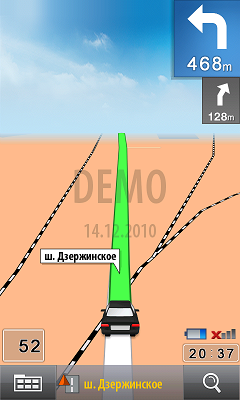
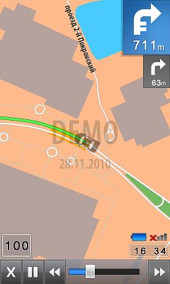
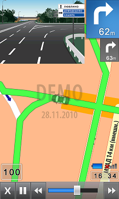
The main advantage of the company is positioning the ability of the navigator to show additional images at junctions and turns that are completely in line with reality.
For example, at some difficult interchange or triple fork promise beautiful pictures with the necessary arrows and clues - the same Navitel is one of the children's sores (when you are already at a fork and there is practically no time for maneuver, but where it is still not clear). I was immediately bribed by such beauty promises, but at the same time remove doubts about covering - did anyone draw draws all over the country? What was my surprise when I saw the first promised picture at the entrance to the city (interchange with the Moscow Ring Road)! A little later, they repeatedly repeated in Mega, in the bustle and labyrinths of which even a knowledgeable person may become confused. Super.
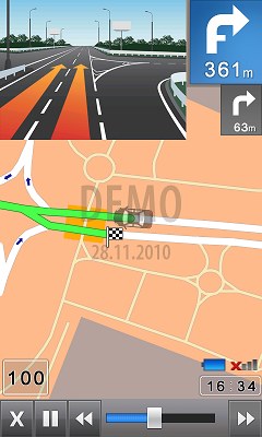
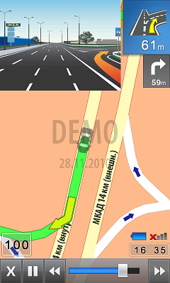
When I arrived home, I began to dig even more into the prog - I met the “demo” mode, which I didn’t pay attention to at first) It just allows “virtually” to drive any route - using his example, I looked where these very pictures are (by the way, they have the official name - JunctionView). In the center they turned out to be quite a lot, and they are not only at junctions, but also on some circular movements, as well as on multi-lane highways. Several times came across places where the navigator prompted on which lane to rebuild for the next maneuver - a trifle, but nice.
What else? Yes, everything seems to be, more, I don’t demand much from the navigator) POIs are searched and shown regularly, and for very many points (where I looked) contact numbers were registered, which can also be useful. Service traffic jams ... well, yes, perhaps it would not be bad)
During the ride you can call the so-called SmartMenu, the items (functions) of which can be changed to fit your requirements.

The HD2 does not slow down at all (as well as the Navitel), but I don’t know about less productive devices.
By the way, I walked a little on the company's website - there you can register and buy a prog through your personal account (payment systems are just sea, there is even a bank. Vkontakte - I hear about it for the first time), report changes in the terrain, or something else. Among the information I found the company's plans to expand the cards for the first quarter - check out the list. Well, it seems like the service of traffic jams is promised, but so far it is still not there.
By the way, the best part is the price for the product. All Russia will cost just 950 rubles!
Liked
- There are versions for different devices and for 480x800 resolution;
- The interface is fully optimized for finger control;
- Editable menu of quick access to the necessary functions;
- Detailed map of Russia, a high level of detail;
- A separate item - three-dimensional (2.5D) buildings;
- Several routing algorithms;
- Multiple color schemes for maps;
- Solid base POI + directory;
- Ability to record the route;
- Low price (950 rubles)
Did not like
- Not supported multitouch;
- Service traffic jams in the plans, but so far it is not;
- A noticeable delay when re-routing the route;
- Manual zoom is not smooth, but with a fixed step;
- There is no possibility to choose the type of vehicle - a pedestrian or lisaped;
- In 2D mode, the path trajectory strip sometimes closes the longitudinal signatures of the road;
- I don’t know what to call short *
* I didn’t like that the software doesn’t work out the turns very quickly - I already drove a couple of times on the road after the turn, while the navigator showed that I was just turning. And after that a sharp change of the map - where I am already on the same road, “jumping” a turn. And I was hoping that the turns and congresses would be one of the trumps of the program - after all, three-dimensional complex interchanges go first in the list of program benefits. I hope this is all due to bad weather.
As for the service of traffic jams ... then I found such an interesting test of navigation systems. In the real world, several navigators were driving, each of which had made his own route. PocketGis arrived the fastest (with the online traffic service), but the route was exactly the same as that of the city. So, it seems, an expert in laying the routes the town still knows)
The program made a double impression on me. Most of all, the sediment remained because of the strange behavior on the turns, while I liked almost everything else - the interface brought to mind, fast work and detailed maps.
While I stayed at Navitel - first of all, because I have it licensed and every time I start it does not offer to spend a couple of rubles;) Secondly, it has a multitouch, without which it would be just inconvenient - you will quickly get used to the good. I think that is why in Progorod I did not find for myself more compelling reasons to change the navigator. Burn bridges did not - left the software, see what happens after a while. Although what's the point - the demo version will end (but the time of the hard-rezet will do ;-)
We have to admit that the creators of Progorod have really seriously tried - their newly-made navigator is already a little inferior to the leaders of the industry, and, judging by all, the situation will only get worse. Ambitious plans for the development of the product, constant work on the existing maps, the seizure of new territories ... and all this with an adequate pricing policy - it seems that I have just listed a couple of steps of the company on the road to success)
The rest of the program turned out to be really worthy - it already now performs its main function confidently. From which we can conclude that users are not limited to the monopoly activity of any one company - among the good navigators there is already a rich choice for all occasions.
Although ... if she had a version for BB, which could be attached to the CarPC - I would have thought again carefully;)
Successes!
But seriously, the navigator advised to try one friend of the girl, who said in one conversation that “ he is no worse than Navitel ” - to some extent this also hurt me)
And I decided to see what they have for the city for this)
')
It all started with the download of the software itself. This is almost 400MB from the manufacturer's website. There are versions for navigators (WinCE 5.0 and higher), communicators (WM not lower than 5.0) and phones (J2ME).
Naturally, I chose a middle ground - for my HTC HD2. But the fact that there is a software version specifically for navigators is good - in case you like it, you can pour it into the navigator (it has a larger screen diagonal + there is a mount on the glass).
There are no problems with the installation - it can be done both from a computer and immediately on a PDA. A minute later, a new icon appears in the launch with a normal resolution - tadam.
Starting in 4 seconds is a promising start. I turn off and look at the task manager - I only missed 10 megabytes.
Large buttons-icons and a very nice interface as a whole - what is needed during the road and what is already there in many places)
So go ahead. In the main menu there are 4 tabs - “Search”, “Route”, “Settings” and “Personal” - on each tab there are several pages of functions (6 per page).
1. Search
It can be different:
- Quick search . It is carried out at the addresses, points of interest of the POI, as well as metro stations without selection by region or locality;
- Address search . Hierarchical search by address is carried out taking into account the Russian specificity of addressing (corpus, structure, ownership, etc.);
- Search points of interest POI by address . You can select the POI category of interest, or search in all (sub) categories and then select from the list of obtained results.
The search is carried out within a radius of 3 kilometers from a specific address, from a certain position, along a route or at its finish, as well as at the cursor on the map. Thematic framework - “Everything, cars, restaurant, transport, hotel, trade, finance, medicine, sport, religion, culture / entertainment, traffic police, education, facilities, home, sanatorium, veterinarian, lakes and shopping and recreation center” - IMHO, some that could be combined. Almost every category contains pages of subcategories.
- Search by coordinates . We set the latitude and longitude and go.
Also on this tab is the "Favorites" and "History."
2. Route
- Information about the route . Start and end points, method (short, fast or convenient), distance and time.
- Maneuvers . Just a list of maneuvers to be done along the route.
- Detours . After analyzing the route, the program will show a list of streets that will have to go. If you mark unnecessary streets with daws, the route will be rebuilt bypass.
- Save and load the route . In case you make a difficult route, you can save it later ... yes, no matter how strange it sounds, to load.
- Record route . In case you go somewhere at random without a route - so that you can get back or repeat the check-in later.
3. Settings
- Interface language . The choice is initially only Russian and English.
- Voice . You can choose uncle or aunt. I would like to be able to upload someone else.
- Planning options . There are three route calculation algorithms - convenient (main), short (the shortest distance between points of the route) and fast (the least number of maneuvers).
Accordingly, choosing a route, you can see all three options on the map (they will be printed in different colors and, possibly, will sometimes coincide). Very useful feature!
You can also choose the types of roads that will be used when laying the route - unpaved, main and paid. The function "Consider traffic jams" is still deactivated, but it seems like this year the service should be launched.
- Setting support . There are two types of scaling - depending on the speed of movement and on the distance to the next maneuver. Two types of accompaniment - the usual (in map mode) and in the "turn-by-turn" mode. With regard to escort - an indication of the remaining distance to the maneuver, as well as to the next maneuver
- Map options . As elsewhere there is a function of changing colors for day and night, and these time intervals can be edited. The function of 3D buildings is naturally activated! :) There are 9 types of cursor to choose from - the one that will move around the map; there must naturally be a black car, not otherwise. And at the very end - a choice of 15 categories of POI, which will be displayed on the map (you can turn off all unnecessary theaters there, leaving only the metro, fast food, ATMs and gas stations)
- System settings . Font size and type, sound volume, type of keyboard for input (ABC or QWERTY)
- Warnings . Almost everywhere there is a warning function for suddenly approaching radars. Here you can specify three distances (300, 700 and 1000m), to which a warning will be heard. You can set all three distances. Well, if you exceed the speed - also expressed.
- Interface style . Initially, only two types are available (both very successful), but apparently, you can download additional themes from Ineta.
4. Personal
Here is the favorites, the history of the finish points, the search history, “my warnings” and “my tracks”.
First of all, I wanted to check the accuracy of the map using the example of my city - something, and I know him well. A country is available - Russia, in it I choose a region - the Moscow region (there are 32 regions in total). Then I enter the first letters of my city (5,000 cities in total are available) - located. Further the street and the house.
The map shown is more than accurate - although I was not surprised) The errors were only on the old iGo, where the buildings with the letter names of the buildings were incorrectly signed and dirt roads were run where it was impossible to drive on the tank). All the houses have been signed, there are internal courtyards (if you can call them that), everything is great and more than true.
But the most pleasant thing happened when I pressed the angle change button - all the houses became pseudo-voluminous! Well, or as they call it, 2.5D. The height of the buildings is approximately proportional to their real height, and all the signatures turn into pretty balloons. This has already happened somewhere, but I really liked the implementation in the city.
Why three-dimensional houses? I agree that this will certainly load the device more, but in this case it becomes even faster and easier to navigate the terrain!
A day later, I tried to ride on the navigator, but I did not go to the center. Satellites are caught stably and without problems.
In principle, more than you can drive - the navigator does an excellent job with its work ... But I didn’t like some nuances.
For example, when I turned around and turned on, the navigator showed that I was just driving around a turn ... and after a moment, with a jerk, it showed the way where I was going. Such a delay is unlikely for anyone to like (and if the speed is even higher, the difference will become much more noticeable), although I do not rule out that this may be due to high cloud cover. In any case, the sediment remained.
The main advantage of the company is positioning the ability of the navigator to show additional images at junctions and turns that are completely in line with reality.
For example, at some difficult interchange or triple fork promise beautiful pictures with the necessary arrows and clues - the same Navitel is one of the children's sores (when you are already at a fork and there is practically no time for maneuver, but where it is still not clear). I was immediately bribed by such beauty promises, but at the same time remove doubts about covering - did anyone draw draws all over the country? What was my surprise when I saw the first promised picture at the entrance to the city (interchange with the Moscow Ring Road)! A little later, they repeatedly repeated in Mega, in the bustle and labyrinths of which even a knowledgeable person may become confused. Super.
When I arrived home, I began to dig even more into the prog - I met the “demo” mode, which I didn’t pay attention to at first) It just allows “virtually” to drive any route - using his example, I looked where these very pictures are (by the way, they have the official name - JunctionView). In the center they turned out to be quite a lot, and they are not only at junctions, but also on some circular movements, as well as on multi-lane highways. Several times came across places where the navigator prompted on which lane to rebuild for the next maneuver - a trifle, but nice.
What else? Yes, everything seems to be, more, I don’t demand much from the navigator) POIs are searched and shown regularly, and for very many points (where I looked) contact numbers were registered, which can also be useful. Service traffic jams ... well, yes, perhaps it would not be bad)
During the ride you can call the so-called SmartMenu, the items (functions) of which can be changed to fit your requirements.
The HD2 does not slow down at all (as well as the Navitel), but I don’t know about less productive devices.
By the way, I walked a little on the company's website - there you can register and buy a prog through your personal account (payment systems are just sea, there is even a bank. Vkontakte - I hear about it for the first time), report changes in the terrain, or something else. Among the information I found the company's plans to expand the cards for the first quarter - check out the list. Well, it seems like the service of traffic jams is promised, but so far it is still not there.
By the way, the best part is the price for the product. All Russia will cost just 950 rubles!
Liked
- There are versions for different devices and for 480x800 resolution;
- The interface is fully optimized for finger control;
- Editable menu of quick access to the necessary functions;
- Detailed map of Russia, a high level of detail;
- A separate item - three-dimensional (2.5D) buildings;
- Several routing algorithms;
- Multiple color schemes for maps;
- Solid base POI + directory;
- Ability to record the route;
- Low price (950 rubles)
Did not like
- Not supported multitouch;
- Service traffic jams in the plans, but so far it is not;
- A noticeable delay when re-routing the route;
- Manual zoom is not smooth, but with a fixed step;
- There is no possibility to choose the type of vehicle - a pedestrian or lisaped;
- In 2D mode, the path trajectory strip sometimes closes the longitudinal signatures of the road;
- I don’t know what to call short *
* I didn’t like that the software doesn’t work out the turns very quickly - I already drove a couple of times on the road after the turn, while the navigator showed that I was just turning. And after that a sharp change of the map - where I am already on the same road, “jumping” a turn. And I was hoping that the turns and congresses would be one of the trumps of the program - after all, three-dimensional complex interchanges go first in the list of program benefits. I hope this is all due to bad weather.
As for the service of traffic jams ... then I found such an interesting test of navigation systems. In the real world, several navigators were driving, each of which had made his own route. PocketGis arrived the fastest (with the online traffic service), but the route was exactly the same as that of the city. So, it seems, an expert in laying the routes the town still knows)
Result
The program made a double impression on me. Most of all, the sediment remained because of the strange behavior on the turns, while I liked almost everything else - the interface brought to mind, fast work and detailed maps.
While I stayed at Navitel - first of all, because I have it licensed and every time I start it does not offer to spend a couple of rubles;) Secondly, it has a multitouch, without which it would be just inconvenient - you will quickly get used to the good. I think that is why in Progorod I did not find for myself more compelling reasons to change the navigator. Burn bridges did not - left the software, see what happens after a while. Although what's the point - the demo version will end (but the time of the hard-rezet will do ;-)
We have to admit that the creators of Progorod have really seriously tried - their newly-made navigator is already a little inferior to the leaders of the industry, and, judging by all, the situation will only get worse. Ambitious plans for the development of the product, constant work on the existing maps, the seizure of new territories ... and all this with an adequate pricing policy - it seems that I have just listed a couple of steps of the company on the road to success)
The rest of the program turned out to be really worthy - it already now performs its main function confidently. From which we can conclude that users are not limited to the monopoly activity of any one company - among the good navigators there is already a rich choice for all occasions.
Although ... if she had a version for BB, which could be attached to the CarPC - I would have thought again carefully;)
Successes!
Source: https://habr.com/ru/post/83682/
All Articles