Rescuers in Haiti use OpenStreetMap
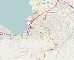
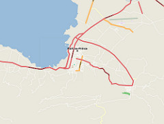 The picture on the left is the OSM map before the earthquake. On the right - as of January 14, two days (!) After the earthquake. This is the result of the works of the OpenStreetMap participants who painted them. I think that even Google was not capable of that. And now there is such a detail that simply can not believe that this is Haiti, and not New York.
It says that all the maps of Haiti were paper and outdated, and maps suitable for navigators simply did not exist. The blogs had a lot of thanks to the OSM participants for making a couple of days not only the map, but a lot of actual marks (tent camps, hospitals) on it.
Further quotation, but under the cut there are more quotes and links.
I am now in Port-au-Prince with the US search and rescue team. I wanted to have a way that I can properly tell you how important your OSM files were to us. Most of our team members have their own Garmin Rino and 60CSx devices. Having such detailed maps on our GPS is a big deal. Soon after finding your job, I quickly told everyone how much we could have downloaded maps with street-level details to many Garmin navigators before sending American rescue teams to the streets. Team members were amazed that they have this resource that you created. I wanted you to see how their faces glowed when I gave them GPS devices and told them that I was going to give them maps with street-level details. They worked VERY diligently and everything that could help them in every aspect of their mission is highly appreciated. I told about this work to all rescue and humanitarian teams here in Haiti. Please be sure that we use your data - I would just like to know about them early. THANKS YOU!
Post from the blog OpenGeoData from January 24 , more details - here .
')
There were at least 400 edits of Haiti's OpenStreetMap after the earthquake. Most are delineating Yahoo snapshots and carefully collecting information from old CIA maps. We have also just received permission to use GeoEye images taken after the earthquake, which will allow us to mark the collapsed buildings.
Post from the blog OpenGeoData January 14
I will also quote the wonderful post Map of Haiti for lifeguards from OpenStreetMap :
“I draw attention to the fact that it was painted not for years, and not for months, but for a few days. This is really where you can’t do without teamwork. One person could not do anything in a situation like this in Haiti. I met on many Western blogs thanks to the OpenStreetMap team, because Google's map in the face of disaster was not very usable, while on the OSM map every day there were new marks, blockages, walkways, camps of the victims - all the relevant information. This time, the open-source project clearly outplayed the Google giant. With all my love for the Internet giant, I am pleased with the superiority of OpenStreetMap in this case. ”
But, by the way, Google is also great . Would you be able to make a Russian-Chukchi translator in two weeks ? =))
UPD: Excellent posts with good links were on blog.kosmosnimki.ru/2010/01/20/crowdsourcing_haiti and osm.komzpa.net/index.php/2010/01/25/gaiti-sos-help-us
UPD2: As I understand it on Habré there are people who helped OSM in various ways: gislab and godnik .
Source: https://habr.com/ru/post/83513/
All Articles