Experiment: How it works ... maps.google.com + maps.live.com
Having seen this on Habré, I decided to try something. What is java and FireBug to this day I have never seen. The more interesting ...
The fact is that I live in Tambov , and a snapshot of such a small town from a google satellite of very weak detail. More recently, I learned that on maps.live.com is an excellent satellite image of my native city.
Here is the maximum available for today Tambov detailing from both services.
Inspired by what was read here and here I decided to try to throw a snapshot of live.com on googlmaps. Because A bunch of delicious food is tied to Google's maps and they all have a well-known API.
The first experiments with FireBug allowed us to make some very interesting discoveries regarding live.com ....
The same piece of the map from different services, the borders matched perfectly !!!
Live.com shared the Earth in the same way as Google did, but they changed the numbering of the tiles.
Consider for example a tile
http://ecn.t1.tiles.virtualearth.net/tiles/a12031123231111.jpeg?g=282&mkt=en-us
The file name we have is a12031123231111.jpeg. To get an enlarged image, divide it into 4 parts, as in the figure. If we need a tile from the square number 0, then the file name is the following a120311232311110.jpeg. Simply append the number of the desired square to the file name. (It reminds of civil defense lessons when studying squares on military maps)

')
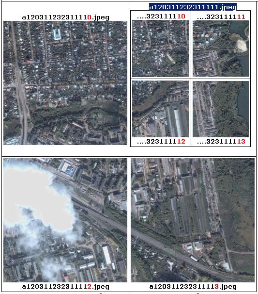
If you need to get an image with a smaller scale, then simply erase the last digits in the file name.
Those. the whole Earth was originally divided into 4 squares. And then we drove to approach a very funny quest. :)

The conclusion that I made for myself. I download images from Live.com and tie them to googlemaps.
Immediately a thought arises, why download, if the pictures are already available online. In general, the idea was to make a parser that uses GoogleMaps imposes tiles from Live.com. I will write about this in the next article, if anyone is interested ...
What came out of this can be seen here .
UPD: Already after writing, I found out about the SASGIS program, in which all this has already been implemented ...
The fact is that I live in Tambov , and a snapshot of such a small town from a google satellite of very weak detail. More recently, I learned that on maps.live.com is an excellent satellite image of my native city.
Here is the maximum available for today Tambov detailing from both services.
 |  |
|---|
Inspired by what was read here and here I decided to try to throw a snapshot of live.com on googlmaps. Because A bunch of delicious food is tied to Google's maps and they all have a well-known API.
The first experiments with FireBug allowed us to make some very interesting discoveries regarding live.com ....
- the image is also represented by layers
- the image is also divided into pieces in the form of jpg files of size 256 x 256px, called tiles (tile)
- the boundaries of the sections are the same !!! (cheers comrades)
- Live.com gives more detail than can be obtained through the site. (This does not mean that the image on them is clearer, but the fact is that they exist)
The same piece of the map from different services, the borders matched perfectly !!!
|  |
|---|
Live.com shared the Earth in the same way as Google did, but they changed the numbering of the tiles.
Consider for example a tile
http://ecn.t1.tiles.virtualearth.net/tiles/a12031123231111.jpeg?g=282&mkt=en-us
The file name we have is a12031123231111.jpeg. To get an enlarged image, divide it into 4 parts, as in the figure. If we need a tile from the square number 0, then the file name is the following a120311232311110.jpeg. Simply append the number of the desired square to the file name. (It reminds of civil defense lessons when studying squares on military maps)
')
If you need to get an image with a smaller scale, then simply erase the last digits in the file name.
Those. the whole Earth was originally divided into 4 squares. And then we drove to approach a very funny quest. :)
The conclusion that I made for myself. I download images from Live.com and tie them to googlemaps.
Immediately a thought arises, why download, if the pictures are already available online. In general, the idea was to make a parser that uses GoogleMaps imposes tiles from Live.com. I will write about this in the next article, if anyone is interested ...
What came out of this can be seen here .
UPD: Already after writing, I found out about the SASGIS program, in which all this has already been implemented ...
Source: https://habr.com/ru/post/60370/
All Articles