Lost aircraft found on Google Earth
After two and a half years of searching, the relatives nevertheless found a private plane that disappeared without a trace in the forests of Arizona on September 24, 2006. The find was made possible by the army of Internet helpers who discovered the catastrophe area through Google Earth .
In fact, the story is quite long. The searches were unsuccessful, until one of the search participants found some amateur photos taken by some biker in the region of interest and dated precisely to the days of the alleged disaster somewhere on the web. In one of the photographs, a plot in the forest was visible, where traces of a recent fire were clearly visible ( smoke in the photo ).
But the problem is that no one knew the coordinates where the photo was taken. This is where crowdsourcing through Google Earth helped. According to aerial photographs of the forests of Arizona, it was possible to perfectly determine the place where the picture was taken (see a comparative analysis of topographical signs ).
')
They immediately organized an expedition to the discovered area, found the crash site there, and now the authorities officially confirmed that yes, these are really fragments of the missing N2700Q aircraft.
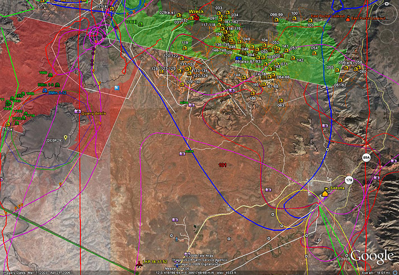
The place with the smoke in the photo perfectly met all the criteria for finding the crash site. By the way, the search criteria for the crash site itself are the result of careful work on the analysis of the flight trajectory, the height and speed of the aircraft, the analysis of hiking routes in that area, the areas already surveyed, etc. A total of 15 criteria were taken into account, they are shown in the diagram .
This analysis system to search for missing aircraft using Google Earth information may well be used in the future. The developers called it MARSI (Mapped Archive of Rescue & Search Information) and published the entire methodology on their website.
In fact, the story is quite long. The searches were unsuccessful, until one of the search participants found some amateur photos taken by some biker in the region of interest and dated precisely to the days of the alleged disaster somewhere on the web. In one of the photographs, a plot in the forest was visible, where traces of a recent fire were clearly visible ( smoke in the photo ).
But the problem is that no one knew the coordinates where the photo was taken. This is where crowdsourcing through Google Earth helped. According to aerial photographs of the forests of Arizona, it was possible to perfectly determine the place where the picture was taken (see a comparative analysis of topographical signs ).
')
They immediately organized an expedition to the discovered area, found the crash site there, and now the authorities officially confirmed that yes, these are really fragments of the missing N2700Q aircraft.
The place with the smoke in the photo perfectly met all the criteria for finding the crash site. By the way, the search criteria for the crash site itself are the result of careful work on the analysis of the flight trajectory, the height and speed of the aircraft, the analysis of hiking routes in that area, the areas already surveyed, etc. A total of 15 criteria were taken into account, they are shown in the diagram .
This analysis system to search for missing aircraft using Google Earth information may well be used in the future. The developers called it MARSI (Mapped Archive of Rescue & Search Information) and published the entire methodology on their website.
Source: https://habr.com/ru/post/58370/
All Articles