World Globalization Map
The European Research Center in Ispra (Italy), with the help of the World Bank, did a titanic work, making a world map of all road, rail, sea and river roads on planet Earth. They calculated the time of movement on each of the types of transport routes, and also made delays at the intersection of national borders (from 1 to 240 minutes) and physical terrain.
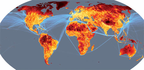
As a result, they received a universal map showing how quickly you can get to every point of the planet from the nearest city with a population of at least 50,000 inhabitants (excluding air transport). Some research results are surprising. It turns out that as many as 90% of our planet is in the 48-hour access zone. Even in such seemingly "undeveloped" territories as Brazil (with the forests of the Amazon), 80% of the territory is located in this zone.
')
Here are some of the most interesting fragments of the map under Habrakat (almost all the pictures are clickable).
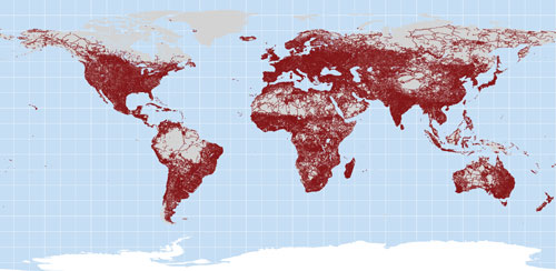
This map of roads on the planet, obtained from satellites.
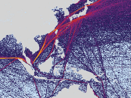
In reality, satellite data even allows to classify roads by type of coverage. For example, here is a fragment of the African coast.

Unlike highways, laying railways spends serious investments and the work of qualified personnel. Therefore, a dense railway cover on Earth exists only in Europe, America and several other corners of civilization, mainly in the former colonies (India, South Africa, Australia, etc.).

Below is a map of sea transport. Bright color highlights the main trade routes.
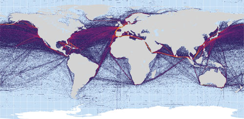
The power of the work of the global manufacturing factory, which has now moved to China, is clearly visible.
River transport still plays a crucial role not only in transportation, but also for the movement of people. For example, the river is the fastest way to some parts of eastern Colombia. In their model, scientists took the speed of movement along the river at 20 km / h, although they note that in reality this speed very much depends on various factors.

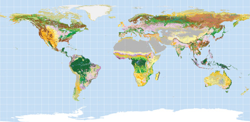
This scheme reflects the terrain, the density and type of vegetation. This scheme was taken into account for modeling the walking speed. On click, a large map is opened with each type decrypted.
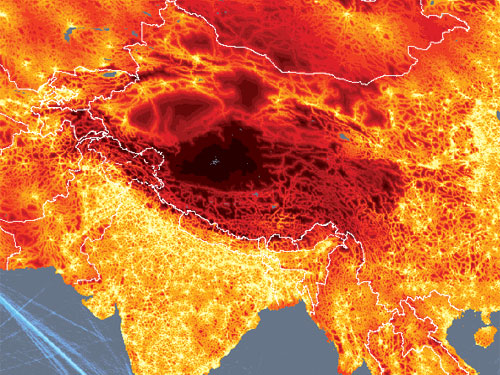
As a result, the study showed that the most remote and inaccessible corner of human civilization is on the Tibetan plateau, namely at the point of coordinates 34.7 ° N, 85.7 ° E. From the nearest town, there is a three-week journey, including 20 days on foot. Otherwise, this point can not be reached.
However, all of this research has one drawback, namely, it does not take into account the air transport. In fact, the same Tibet is not a problem to fly into a helicopter in a few hours, so in fact there are no de facto completely secluded corners on our planet.
As a result, they received a universal map showing how quickly you can get to every point of the planet from the nearest city with a population of at least 50,000 inhabitants (excluding air transport). Some research results are surprising. It turns out that as many as 90% of our planet is in the 48-hour access zone. Even in such seemingly "undeveloped" territories as Brazil (with the forests of the Amazon), 80% of the territory is located in this zone.
')
Here are some of the most interesting fragments of the map under Habrakat (almost all the pictures are clickable).
This map of roads on the planet, obtained from satellites.
In reality, satellite data even allows to classify roads by type of coverage. For example, here is a fragment of the African coast.
Unlike highways, laying railways spends serious investments and the work of qualified personnel. Therefore, a dense railway cover on Earth exists only in Europe, America and several other corners of civilization, mainly in the former colonies (India, South Africa, Australia, etc.).
Below is a map of sea transport. Bright color highlights the main trade routes.
The power of the work of the global manufacturing factory, which has now moved to China, is clearly visible.
River transport still plays a crucial role not only in transportation, but also for the movement of people. For example, the river is the fastest way to some parts of eastern Colombia. In their model, scientists took the speed of movement along the river at 20 km / h, although they note that in reality this speed very much depends on various factors.
This scheme reflects the terrain, the density and type of vegetation. This scheme was taken into account for modeling the walking speed. On click, a large map is opened with each type decrypted.
As a result, the study showed that the most remote and inaccessible corner of human civilization is on the Tibetan plateau, namely at the point of coordinates 34.7 ° N, 85.7 ° E. From the nearest town, there is a three-week journey, including 20 days on foot. Otherwise, this point can not be reached.
However, all of this research has one drawback, namely, it does not take into account the air transport. In fact, the same Tibet is not a problem to fly into a helicopter in a few hours, so in fact there are no de facto completely secluded corners on our planet.
Source: https://habr.com/ru/post/58085/
All Articles