Using GPS in Ubuntu
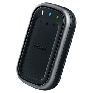
Many sysadmins like the E61 Nokia phone. For its time, stuffed with different communication formats, in addition to standard GSM / UMTS, IR, Bluetooth and WiFi, (push-to-talk). QWERTY-keyboard (full). Big bright screen. High-quality assembly and metal back. It was in the phone and a few drawbacks, some consider them irrelevant. So: no camera, big size, no FM, and no GPS. In addition to size, all other problems are solved. For GPS, I purchased a nokia LD-3W .
Using maps on this screen is a pleasure. After some time, I wanted to connect the receiver to the Acer Aspire 5720 laptop in which there is a built-in bluetooth. Ubunt Intrepid Ibex (8.10) is installed on the laptop. Now this company needs to be moved.
First, let's do:
')
since bluetooth is already in the laptop, when installing ubunt, support for bluetooth was enabled. But add this package anyway. By default, the receiver cannot be added, because there is no where in it to enter the pin. Therefore, we continue to read further. Turn on the receiver and execute the command:
In the output, we get something like this:
Save the MAC address (remember, it is unique for each device). Now find out the receiver channel:
By default, this is Channel 1. In the config, you need to enter this data according to a template:
sudo gedit /etc/bluetooth/rfcomm.conf
Run:
(here 0 if the receiver is the first device that is connected, in my case several phones have already been connected, therefore you need to either remove the connections, or change 1, 2, 3, etc.).
Connecting:
After this command, the bluetooth daemon will ask you to enter pin (only once), the default code for this receiver is 0000.
Now you need to install the daemon:
Run:
And look at the satellites:

The main FAQ is here .
After successful connection of the receiver with the laptop, in particular, with ubuntu, you need to install software for working with cards. In brief, I will describe several programs that did not work, for various reasons. One of the most popular - Viking - did not work, because Received data only from Garmin and Magellan. Therefore, it was not possible to evaluate the functionality. Gpsdrive received data from the receiver and showed the coordinates, but the lack of maps was disheartening.

Although the settings are quite decent, which include the method of movement: bicycle, car, on foot. Probably, you can also get maps, import, but I want a simpler way.
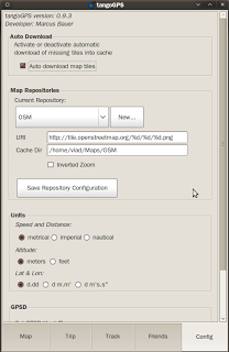
And there is happiness! This is TangoGPS .

Note cards in their own language. Of course, universal English is not a problem, but it's nice anyway. In the beginning there was a small cant with the installation, on my own site there is a redirection to the openSUSE build service , where I found .deb for amd64.
The window of the program reminded the style of Mas-software:

In addition to the map there is general information about the way. Logging the traversed path for use with OSM (open street map):

The settings are quite simple, automatic loading of maps, not complete, but only the squares available for the current screen. Presentation of the maps in the form of openstreet - a map with street names. Topographic and aerial survey. On the home page, you can read about the other functions and see screenshots of different map views, as well as on which mobile devices the program works.
I give a list of programs that you can try yourself.
Native GPS software for Linux.
And through wine:
In the next trip, if possible, I will test tangogps closely.
Using maps on this screen is a pleasure. After some time, I wanted to connect the receiver to the Acer Aspire 5720 laptop in which there is a built-in bluetooth. Ubunt Intrepid Ibex (8.10) is installed on the laptop. Now this company needs to be moved.
First, let's do:
')
sudo apt-get install bluez-utilssince bluetooth is already in the laptop, when installing ubunt, support for bluetooth was enabled. But add this package anyway. By default, the receiver cannot be added, because there is no where in it to enter the pin. Therefore, we continue to read further. Turn on the receiver and execute the command:
hcitool scanIn the output, we get something like this:
Scanning ...
00:0D:B5:37:3B:A9 Nokia LD3W
Save the MAC address (remember, it is unique for each device). Now find out the receiver channel:
sdptool browse 00:0D:B5:37:3B:A9By default, this is Channel 1. In the config, you need to enter this data according to a template:
sudo gedit /etc/bluetooth/rfcomm.conf
rfcomm0 {
bind yes;
device 00:0D:B5:37:3B:A9;
channel 1;
comment "Serial Port";
}
Run:
sudo rfcomm release 0(here 0 if the receiver is the first device that is connected, in my case several phones have already been connected, therefore you need to either remove the connections, or change 1, 2, 3, etc.).
Connecting:
rfcomm connect 0After this command, the bluetooth daemon will ask you to enter pin (only once), the default code for this receiver is 0000.
Now you need to install the daemon:
sudo apt-get install gpsdRun:
gpsd /dev/rfcomm0And look at the satellites:
xgpsThe main FAQ is here .
After successful connection of the receiver with the laptop, in particular, with ubuntu, you need to install software for working with cards. In brief, I will describe several programs that did not work, for various reasons. One of the most popular - Viking - did not work, because Received data only from Garmin and Magellan. Therefore, it was not possible to evaluate the functionality. Gpsdrive received data from the receiver and showed the coordinates, but the lack of maps was disheartening.
Although the settings are quite decent, which include the method of movement: bicycle, car, on foot. Probably, you can also get maps, import, but I want a simpler way.
And there is happiness! This is TangoGPS .
Note cards in their own language. Of course, universal English is not a problem, but it's nice anyway. In the beginning there was a small cant with the installation, on my own site there is a redirection to the openSUSE build service , where I found .deb for amd64.
The window of the program reminded the style of Mas-software:
In addition to the map there is general information about the way. Logging the traversed path for use with OSM (open street map):
The settings are quite simple, automatic loading of maps, not complete, but only the squares available for the current screen. Presentation of the maps in the form of openstreet - a map with street names. Topographic and aerial survey. On the home page, you can read about the other functions and see screenshots of different map views, as well as on which mobile devices the program works.
I give a list of programs that you can try yourself.
Native GPS software for Linux.
- GpsDrive - a free car (bike, ship, plane) navigation system
- Free GPS Software - An Up-to-Date List
- Linux Applications for GPS Navigation & Geographic Maps
- Review: Four GPS Software Packages for Linux
And through wine:
In the next trip, if possible, I will test tangogps closely.
Source: https://habr.com/ru/post/46821/
All Articles