The battle for the virtual Earth is heating up with a new force
On November 1, Google released a new beta, Google Earth 4 beta (4.0.2416 for Windows and 4.0.2413 for Mac) with enhanced functionality. A very important feature of the paid version of Google Earth Plus has been transferred to the free program. This is an opportunity to draw your own objects on the map. In three-dimensional space, you can now create buildings of almost any complexity ( photos ) and export them in KML or KMZ format.
In addition, since the previous release on September 13, 2006, a lot of small things have been added to the beta: new icons for objects ( photos ), faster loading of 3D models (thanks to caching) and improved backlight for them, support for compressed textures. There was also a function of printing routes in 3D-format, as well as an attribute of height for the imposition of textures, so that now it became possible to depict clouds and other objects above the ground. By the way, the Internet already has services that allow you to receive images of clouds above the ground in real time .
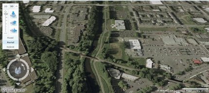
The official release of Google Earth 4 should take place before the end of this year, but competitors in the face of Microsoft have already released a new version of Local Live with 3D function. As you can see, Virtual Earth is not a standalone product like Google’s, but is fully integrated with the online mapping service and other Microsoft services. In a sense, this system can be called revolutionary, because, unlike Google Earth, it works right through the browser, although it does require the installation of a 5 MB module.

')
To test three-dimensional Virtual Earth in action, you need IE 6 or IE 7 (with regional settings on the US), Windows XP SP2, Windows Server 2003 or Vista, DirectX 9, a hardware-accelerated graphics card and a wide channel. Admittedly, the system provides a truly photographic quality and looks just amazing. A small video demonstration of the Microsoft 3D browser can be viewed here (4 minutes after the advertisement).
It is easy to guess that the photographic quality of Virtual Earth objects is ensured by aerial photography. It was actually carried out over each of the 15 cities that are now open for public viewing. For example, on YouTube you can find a short video with a fragment of aerial photography over Eastbourne , which was carried out specifically for Microsoft Virtual Earth.
It is difficult to imagine that, on the order of Microsoft, someday will conduct aerial photography of all the cities of the world, because this is a very laborious procedure. By the end of next summer, they promise to expand the list of cities to hundreds. However, independent developers can help in filling content here, since there are open program interfaces for Local Live. Already, with their help, you can easily integrate a three-dimensional map on your website using a simple script .
In addition, since the previous release on September 13, 2006, a lot of small things have been added to the beta: new icons for objects ( photos ), faster loading of 3D models (thanks to caching) and improved backlight for them, support for compressed textures. There was also a function of printing routes in 3D-format, as well as an attribute of height for the imposition of textures, so that now it became possible to depict clouds and other objects above the ground. By the way, the Internet already has services that allow you to receive images of clouds above the ground in real time .
The official release of Google Earth 4 should take place before the end of this year, but competitors in the face of Microsoft have already released a new version of Local Live with 3D function. As you can see, Virtual Earth is not a standalone product like Google’s, but is fully integrated with the online mapping service and other Microsoft services. In a sense, this system can be called revolutionary, because, unlike Google Earth, it works right through the browser, although it does require the installation of a 5 MB module.

')
To test three-dimensional Virtual Earth in action, you need IE 6 or IE 7 (with regional settings on the US), Windows XP SP2, Windows Server 2003 or Vista, DirectX 9, a hardware-accelerated graphics card and a wide channel. Admittedly, the system provides a truly photographic quality and looks just amazing. A small video demonstration of the Microsoft 3D browser can be viewed here (4 minutes after the advertisement).
It is easy to guess that the photographic quality of Virtual Earth objects is ensured by aerial photography. It was actually carried out over each of the 15 cities that are now open for public viewing. For example, on YouTube you can find a short video with a fragment of aerial photography over Eastbourne , which was carried out specifically for Microsoft Virtual Earth.
It is difficult to imagine that, on the order of Microsoft, someday will conduct aerial photography of all the cities of the world, because this is a very laborious procedure. By the end of next summer, they promise to expand the list of cities to hundreds. However, independent developers can help in filling content here, since there are open program interfaces for Local Live. Already, with their help, you can easily integrate a three-dimensional map on your website using a simple script .
Source: https://habr.com/ru/post/4660/
All Articles