Method of monitoring the current state of Russian highways with users' smartphones
The goal of one of the federal programs aimed at implementing the Presidential Decree "On the national goals and strategic objectives of the development of the Russian Federation for the period up to 2024" No. 204 dated May 7, 2018 ( link ) is to improve the quality of roads by increasing the percentage ratio corresponding to the regulatory requirements.
The same decree provides for the introduction of a publicly available information system to control the formation and use of road funds at all levels.
However, objective quality control of carrying out activities for the construction or repair of roads is difficult for a number of reasons, ranging from notorious problems a la corruption in construction ( link ), and ending with natural causes of laboriousness in organizing such a process using existing methods - using reiki and wedge -prometnik, road profilometer or tolkomera, by the method of amplitudes, etc. (the cost of measuring the quality of roads, the need to travel to the site, limited human and technical resources).
')
Specialists are taking steps to simplify the process of diagnosing flatness of roads ( link ), but still the possibility of large-scale studies of their quality is extremely limited.
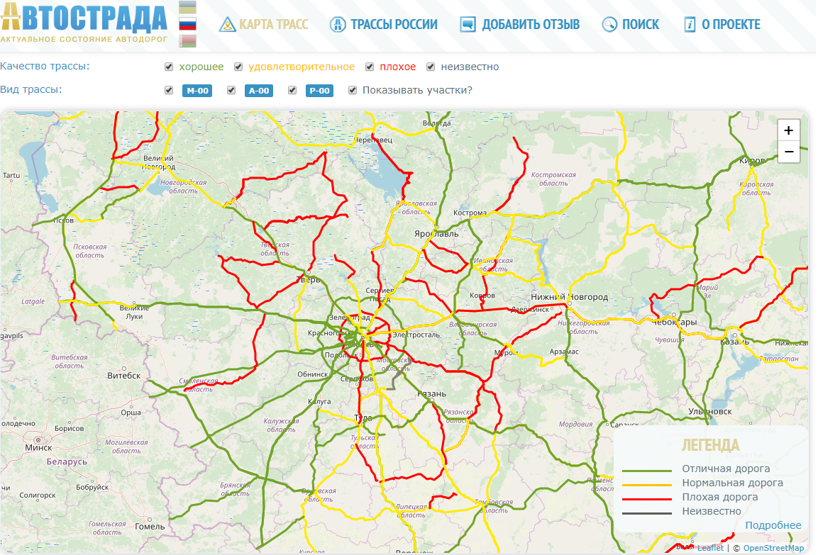
Existing projects like “Autostrada” (autostrada.info), “Road Inspection ONF” (dorogi-onf.ru) are filling their base of road quality mainly due to feedback from users who send photos or reviews only about certain sections of roads.
However, one of the outputs of quality control of the pavement, as well as tracking its changes, both for the better and for the worse, is the aggregation of already existing analytical tools.
To begin with, vehicle drivers are for the most part users of smartphones that have the default functions of a gyroscope, accelerometer (hereinafter referred to as sensors) and GPS / Glonass navigation.
The evenness of the road surface is one of the basic indicators of the quality of the road and is characterized by longitudinal and transverse flatness (rutting).
A mobile phone with sensors capable of constantly tracking all movements, including those characteristic of irregularities.
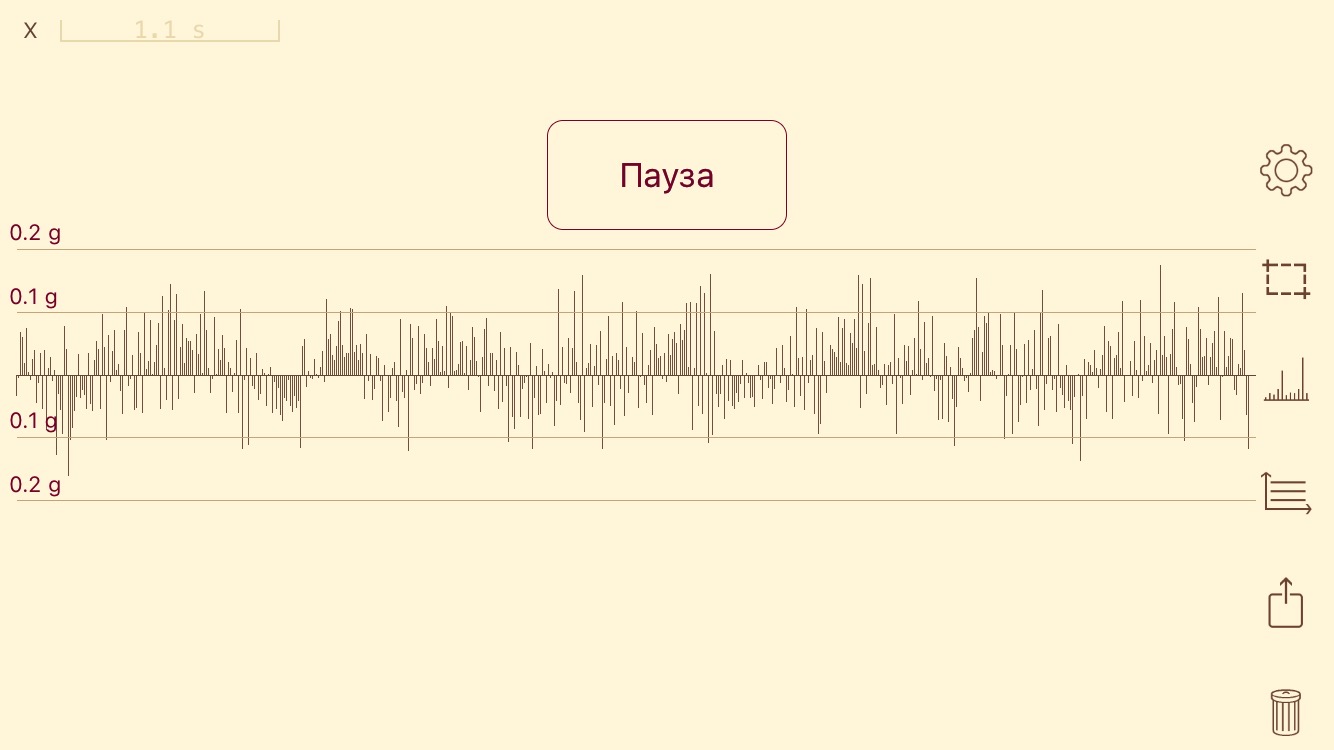
The figures below show real data from the accelerometer of a smartphone located in a vehicle under various conditions:
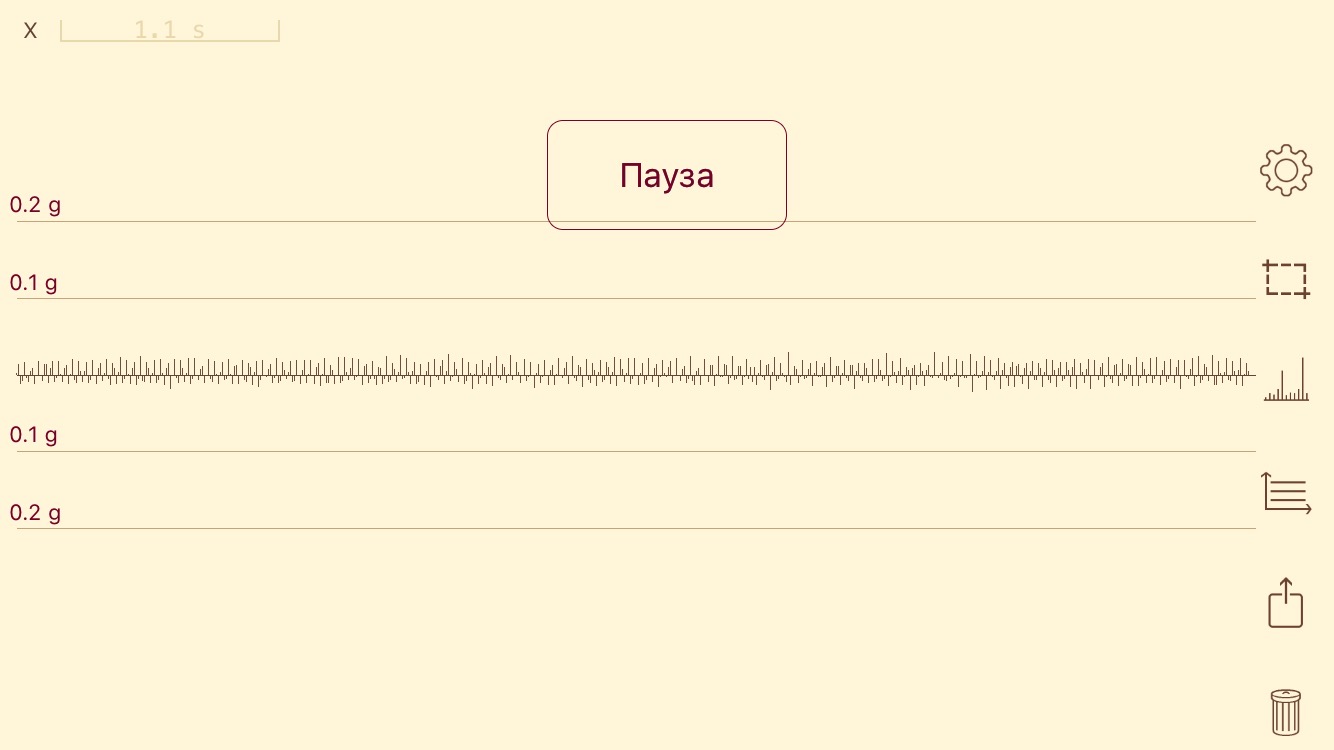
Motionless
Driving on a good road (speed 80 km / h)

Driving on a good road (speed 80 km / h) with moving overpass junction

Moving two "speed bumps" (speed 20-30 km / h)

Uneven road (speed 30 km / h)
Vibrations along different axes in our three-dimensional space can be visually shown in the following figure, where different colors characterize each projection. In other words - X (up and down) prevails when driving irregularities, Y (left and right) - when rebuilding or avoiding obstacles, Z (front and back) - when braking / accelerating.
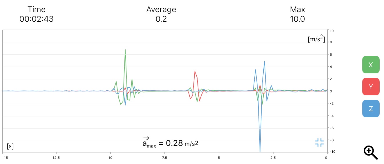
The combination of these data can give a unique imprint of each type of road defect.
Geolocation allows you to correlate phone sensor data with specific coordinates, as well as vehicle speed.
In this regard, based on data from a variety of mobile devices, it is possible to form a quality map of the road surface, which will reflect various road defects (cracks, hollows, pit breaks, rutting, plastic deformation, comb, waves, etc. according to the classification of damage to asphalt concrete pavements ).
For example:
The system itself for automatic recognition of the quality of the road on the data coming from the sensors will need to be trained (on the same neurons), which will not be significant for developers.
At the same time, it is advisable to integrate this method into the already existing infrastructure, for example, Yandex Navigator or similar applications, which are used by a significant number of Russian car owners.
This application a priori collects similar data for their analysis and does not require additional permissions to install and collect data for the practical implementation of such a method.
It is possible to implement the quality map of the coating according to a scheme similar to “Yandex-traffic jams” - according to color gradation from green (GOST quality) to red (low quality) with additional markings of individual road surface defects, and also gray, where statistical data are not enough for objective state reflection
auto highways (for example, low road congestion). In addition, it will be necessary to take into account a number of accompanying factors contributing to some changes in the data without changing the quality of the road (weather conditions / season).
A similar approach to visualization is implemented in the “Autostrada”, however, as stated above, it reflects the subjective assessment of a limited number of users, refers to the entire route, and does not show its individual sections, is not updated in a reasonable time and generally has other significant shortcomings, not allowing to carry out high-quality objective control.
It is also necessary to provide options for "trends of change" and a retrospective view of the state of roads.
Thanks to the implementation of this method, managers at all levels, ranging from subjects of the Russian Federation and ending with local governments, as well as construction and repair organizations, as well as, first and foremost, regulatory bodies, will be able to observe an objective picture of the state of the roadway in any region of Russia, as well as the implementation of the “May” decrees on this topic in a near-real time mode.
In addition, due to a set of statistical parameters, it will also be possible to monitor the level of reliability of a highway, that is, over what period of time its quality will deteriorate to certain indicators, and whether it will meet the standards for road construction / repair ( which will allow, among other things, to identify with such phenomena as the well-known laying of asphalt on snow or water ).
According to all these criteria, it is possible to create an information system for federal monitoring (control) of the state of roads and assess the quality of work of construction contractors, targeted spending of budget funds, work of local governments in the localities, as well as the course of the federal program as a whole.
The same decree provides for the introduction of a publicly available information system to control the formation and use of road funds at all levels.
However, objective quality control of carrying out activities for the construction or repair of roads is difficult for a number of reasons, ranging from notorious problems a la corruption in construction ( link ), and ending with natural causes of laboriousness in organizing such a process using existing methods - using reiki and wedge -prometnik, road profilometer or tolkomera, by the method of amplitudes, etc. (the cost of measuring the quality of roads, the need to travel to the site, limited human and technical resources).
')
Specialists are taking steps to simplify the process of diagnosing flatness of roads ( link ), but still the possibility of large-scale studies of their quality is extremely limited.
Existing projects like “Autostrada” (autostrada.info), “Road Inspection ONF” (dorogi-onf.ru) are filling their base of road quality mainly due to feedback from users who send photos or reviews only about certain sections of roads.
However, one of the outputs of quality control of the pavement, as well as tracking its changes, both for the better and for the worse, is the aggregation of already existing analytical tools.
To begin with, vehicle drivers are for the most part users of smartphones that have the default functions of a gyroscope, accelerometer (hereinafter referred to as sensors) and GPS / Glonass navigation.
The evenness of the road surface is one of the basic indicators of the quality of the road and is characterized by longitudinal and transverse flatness (rutting).
A mobile phone with sensors capable of constantly tracking all movements, including those characteristic of irregularities.
The figures below show real data from the accelerometer of a smartphone located in a vehicle under various conditions:
Motionless
Driving on a good road (speed 80 km / h)
Driving on a good road (speed 80 km / h) with moving overpass junction
Moving two "speed bumps" (speed 20-30 km / h)
Uneven road (speed 30 km / h)
Vibrations along different axes in our three-dimensional space can be visually shown in the following figure, where different colors characterize each projection. In other words - X (up and down) prevails when driving irregularities, Y (left and right) - when rebuilding or avoiding obstacles, Z (front and back) - when braking / accelerating.
The combination of these data can give a unique imprint of each type of road defect.
Geolocation allows you to correlate phone sensor data with specific coordinates, as well as vehicle speed.
In this regard, based on data from a variety of mobile devices, it is possible to form a quality map of the road surface, which will reflect various road defects (cracks, hollows, pit breaks, rutting, plastic deformation, comb, waves, etc. according to the classification of damage to asphalt concrete pavements ).
For example:
- rough road - characterized by the characteristics of the data from the sensors, as well as the average speed less than allowed on this stretch of road;
- potholes - characterized by one-stage features of the data from the sensor and a sharp slowdown in front of it;
- rut - characterized by the characteristics of data from sensors when rebuilding the vehicle;
- other features of the roadway.
The system itself for automatic recognition of the quality of the road on the data coming from the sensors will need to be trained (on the same neurons), which will not be significant for developers.
At the same time, it is advisable to integrate this method into the already existing infrastructure, for example, Yandex Navigator or similar applications, which are used by a significant number of Russian car owners.
This application a priori collects similar data for their analysis and does not require additional permissions to install and collect data for the practical implementation of such a method.
It is possible to implement the quality map of the coating according to a scheme similar to “Yandex-traffic jams” - according to color gradation from green (GOST quality) to red (low quality) with additional markings of individual road surface defects, and also gray, where statistical data are not enough for objective state reflection
auto highways (for example, low road congestion). In addition, it will be necessary to take into account a number of accompanying factors contributing to some changes in the data without changing the quality of the road (weather conditions / season).
A similar approach to visualization is implemented in the “Autostrada”, however, as stated above, it reflects the subjective assessment of a limited number of users, refers to the entire route, and does not show its individual sections, is not updated in a reasonable time and generally has other significant shortcomings, not allowing to carry out high-quality objective control.
It is also necessary to provide options for "trends of change" and a retrospective view of the state of roads.
Thanks to the implementation of this method, managers at all levels, ranging from subjects of the Russian Federation and ending with local governments, as well as construction and repair organizations, as well as, first and foremost, regulatory bodies, will be able to observe an objective picture of the state of the roadway in any region of Russia, as well as the implementation of the “May” decrees on this topic in a near-real time mode.
In addition, due to a set of statistical parameters, it will also be possible to monitor the level of reliability of a highway, that is, over what period of time its quality will deteriorate to certain indicators, and whether it will meet the standards for road construction / repair ( which will allow, among other things, to identify with such phenomena as the well-known laying of asphalt on snow or water ).
According to all these criteria, it is possible to create an information system for federal monitoring (control) of the state of roads and assess the quality of work of construction contractors, targeted spending of budget funds, work of local governments in the localities, as well as the course of the federal program as a whole.
Source: https://habr.com/ru/post/460159/
All Articles