Meteorology and flights
Below is a small FAQ about what is dangerous and what is not for an aircraft, and what you need to know about the weather.
As a rule, passengers greatly overestimate the danger of various phenomena such as turbulence or lightning striking an aircraft wing. But they know nothing about the danger of discharge (such as static), which occurs due to friction of air particles on the surface of the aircraft. Or about the danger to collect a couple of tons of ice on the hull during landing and sit down a little faster than planned.
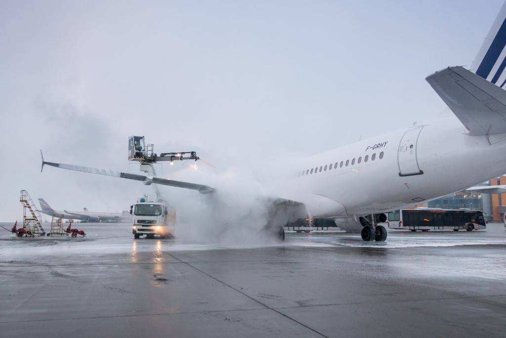
Anti-icing treatment of the aircraft prior to departure.
')
So let's talk about the weather, dear paranoids.
Because the higher you climb, the lower the air density there. And the lower the density of air, the lower its resistance, and consequently, the engine thrust requires less, which provides significant savings. That is, the task is to calculate the optimum, which will allow you to spend the least amount of fuel, taking into account three factors:
As a result, we have current flight conditions. 75% of the mass of the atmosphere is below the echelons occupied by the passenger sides of Moscow-Petersburg, that is, approximately 10 kilometers. At 20 kilometers down there will be already 95% of the mass, and at an altitude of 100 kilometers - 99.9%. At an altitude of about 400 kilometers you can already meet the ISS.
The atmosphere is uneven, and the conditions at the point where the aircraft is located directly affect its flight. For example, the kinetic temperature is a characteristic that determines the effect of particles of air gases on a vessel due to the occurrence of friction force. The length of the takeoff, the allowable flight altitude, and fuel consumption depend on the current kinetic temperature.
Basically, bimetallic plates (metal resistance thermometers) are used to measure the temperature at the ground. Semiconductor thermometers are used for radio sounding.
There are periodic changes in temperature at the aerodrome (it is colder at night than during the day) - this is determined by the heat exchange along the vertical of the atmosphere. Non-periodic associated with advection (horizontal movement of air masses). Usually the coldest thing in the daily rhythm is before dawn, and the warmest of all is about 15 o'clock. Depending on the type of surface, the amplitude of the daily variation of temperature varies: for example, in hollows like in natural thermo-accumulators it is higher and smaller in mountains. The land cools and heats up faster than water. In the north, the reflective properties of surfaces (ice, for example) are important.
In general, the higher the colder. But there are layers (up to 2–3 kilometers) where, due to atmospheric processes, the temperature rises as we climb: these are the so-called inversion zones. At the boundary of the inversion zone, the temperature difference can reach up to 10 degrees. Accordingly, the density of air changes dramatically. These layers retard the movement of air, under them there is a concentration of water vapor and various particles.
Air humidity is determined by a hygrometer. This is a good old biotech: the greater the humidity, the longer human hair. The alternative is a psychrometer: measuring the temperature with a dry and wet thermometer, taking into account the difference. The density of humid air is less than the density of dry.
Wind can be caused by Coriolis force, thermal effects. Wind in aviation has an expiration date: the question is where the measurement was taken and how long it can be expected that it will be relevant. The stronger the wind, the higher the chance of changing its speed and the lower the chance of changing direction. You can fly to the specified place in 5-6 hours, and there will still be a good fit wind.
A cloud is an accumulation of vapor particles and ice crystals (a snowflake is a large ice crystal). The most frequent precipitation begins to fall from the clouds from -10 to -40 degrees. At temperatures above it turns out drizzle, below - nothing falls out.
Clouds are dangerous deterioration of visibility (especially diagonal), thunderstorms, the threat of icing, hail, wind shifts. A transition layer is located below the cloud: it begins where the pilot loses the horizon, and ends where the ground under the plane is no longer visible. Usually it is from 50 to 200 meters. The height of the lower boundary of the clouds above the aerodrome may change twice in 10 minutes. It is usually measured with a light fiber.
The resolution of the eye is 1 angular minute. That is, two points can be separated from each other precisely under this condition. For objects with an angular size of less than 15 minutes, contrast and brightness are very important. The atmosphere reduces brightness and contrast with distance, therefore air transparency is important. The resolution of the eye is considered constant, and the transparency of the atmosphere varies, plus various atmospheric phenomena (fog or rain) can be added. From this meteorological visibility. There is also an RVR indicator, or visibility on the runway: this is the visibility of the marking of a strip or its lights. As in the case of meteorological visibility, it does not include things like the material of the cockpit glass, fatigue, the direction of light, raindrops on the windshield, and so on.
Visibility can greatly reduce such phenomena as darkness (particles of dust, sand and smoke), sandstorms (sand rises to about 15 meters), dust storms (dust rises up to 3 kilometers), sandy and dusty eddies (rarely above 90 meters) , blizzard, fog, haze and so on. Fog, by the way, can be anthropogenic, for example, as a result of the operation of a CHP plant with a frost of -20 degrees. The pilot must understand the properties of each of these phenomena and the mechanisms of their formation and development.
Also, the pilot must understand how the flows in the atmosphere are arranged: the principles of formation and movement of cyclones and anticyclones, what happens at their boundaries and so on. All this influences air currents at different scales.
Takeoff and landing with precipitation (turbulence conditions, with winds exceeding 5 m / s) are made with a margin that the flight characteristics of the vessel may deteriorate.
This ice deposition on engines and streamlined parts of the aircraft. Icing degrades aerodynamics, lift, speed, maneuverability, engine power, interferes with radio communications. The most important thing is the additional mass, which grows as the ice layer increases. If the ice is taken off the surface of the fuselage or wing in flight, its pieces may fall on the rotating vanes and seriously damage the engine. Especially if the engine is behind.
Icing can occur as a result of freezing of water on the surface of the aircraft or as a result of the sublimation of water vapor from the air at the surface. The second process is more characteristic of abrupt temperature changes, for example, at the intersection of inversions.
The kinetic heating of the aircraft against air friction prevents the formation of icing. As a rule, most cases (90%) are observed at speeds up to 600 kilometers per hour. That is dangerous takeoff and landing. Therefore, before taking off in the rain, it is important to treat the aircraft with anti-icing fluid, and at the landing - not to pass through dangerous areas.
These are places where aircraft can be buzzing. As a rule, wind strength and temperature change there. Simplifying mechanical or orographic turbulence is when an air mass strikes an uneven landscape from acceleration or deforms against a mountain. There is also thermal turbulence due to uneven heating of the surface - remember, we used to talk about the reflective properties of various things like ice on the surface?
More turbulence can occur in a clear sky "just like that" - with jet streams or due to convection.
Turbulence zones are usually less than 100 kilometers horizontally and 1 kilometer vertically. Severe turbulence in an area of this size is observed in the “core” with a size of 40 kilometers and 30 meters, respectively. There is such a zone most often up to five hours.
They are looking for turbulence zones with radar and geostationary satellite imagery, plus their appearance can be predicted. When it enters the zone of strong turbulence, the crew must get out of it, and you can independently change the train and report to the dispatcher.
If lightning strikes the plane, then, as a rule, nothing terrible will happen: it has no grounding. More rarely there are holes in the structure at the place of discharge. But still, the most dangerous thing in a thunderstorm is precisely electric phenomena, including those that break communication.
Lightning strikes the potential difference, so you see not everything from the earth: they happen between clouds, inside clouds or from clouds to earth. Sometimes even up. The height of the lightning can be up to 95 kilometers, in the case of the “usual” linear lightning - up to 20 kilometers with a diameter of several tens of centimeters. The current intensity of such a lightning will be about 200 thousand Amperes, the temperature will be about 20 thousand degrees Celsius. And the weak discharge (leader) clears the way for the strong. Usually the leader hits the ground from the cloud, and the main discharge spreads in the opposite direction.
Near thunderstorms there are strong currents, lightning, hail, squalls, tornadoes and microbursts. Plus there are favorable conditions for icing, so pilots should fly around thunderstorms, since they are fairly easy to detect.
The plane, even during normal flight (outside the zone of thunderstorms), is gaining an electric charge. In crystalline clouds, for example, you can very quickly charge the board, because the plane has some properties of a large capacitor, and the cloud is “rough.” When the height changes, the electric field strength changes, and discharges between the plane and the surrounding air can be obtained. With all the protruding parts of the aircraft (for example, from the ends of the wings) can be discharged, so there are special devices that reduce this effect.
The discharge itself resembles a flash when electrowelding. It can damage communication devices, radar, can burn a hole from 1 to 20 centimeters in the case. From such strong discharges protruding parts of the aircraft usually begin to glow noticeably.
Electrification of the board can be seen by the behavior of a number of devices in advance. Usually, it is possible to avoid accumulating a strong charge, but if it suddenly began to form, the pilots shut off one radio station (so that it was a backup in case of discharge), turn on cockpit lighting (so that the flash would not blind at night) and exit the danger zone.
Most weather events are either predicted or detected from the board, airfield sensors or satellites. It is believed that the technical hazard factor is minimized, that is, the technique allows either to predict any dangerous situation, or to get out of it if its prediction is impossible. The last known major incident with the weather occurred during the sintering of volcanic ash inside the engine, when the board failed all four power plants. The crew coped with these minor inconveniences and successfully landed the board. There was an update of the locators, there were new rules for flying around active volcanoes. During the last major eruption in Europe, everything went relatively smoothly. Also worth noting is the recent catastrophe RRJ-95B RA-89098, there is a preliminary report on it.
In Russia, pilots and air traffic controllers take an obligatory course in meteorology and deeply professionally understand what is happening in flight around an airplane.
Therefore, dear paranoids, you can improve the safety of your travel dozens of times by traveling to the airport by train. Or transfer from the front seat of a taxi near the driver to the back and fasten there too. A simple estimate of the likelihood suggests that the main threats are approximately at this site, and not in the air.
The first photo of the post is provided by Yu.V. Filatov (FBO "A-Group")
Our other posts on aviation: Why specifically pour an airplane before departure, and what will happen if you do not do this ? How does business aviation work in Russia (FBO centers) , FBO Sheremetyevo infrastructure: how light airplanes are prepared for flight , Cargo flight , Preparation for flight for pilots , History of in-flight catering and our rating of the “most delicious” airlines , According to what rules does an airplane fly in Russia , Safety of air travel , FAQ about transfers and connecting flights .
As a rule, passengers greatly overestimate the danger of various phenomena such as turbulence or lightning striking an aircraft wing. But they know nothing about the danger of discharge (such as static), which occurs due to friction of air particles on the surface of the aircraft. Or about the danger to collect a couple of tons of ice on the hull during landing and sit down a little faster than planned.
Anti-icing treatment of the aircraft prior to departure.
')
So let's talk about the weather, dear paranoids.
Why do airplanes fly at high echelons, and not, say, 800 meters from the ground
Because the higher you climb, the lower the air density there. And the lower the density of air, the lower its resistance, and consequently, the engine thrust requires less, which provides significant savings. That is, the task is to calculate the optimum, which will allow you to spend the least amount of fuel, taking into account three factors:
- That for the flight of the glider still need a medium to rely on it.
- Need oxygen for engines.
- In this case, the descent and ascent to the desired height should not be more costly than the possible fuel savings.
As a result, we have current flight conditions. 75% of the mass of the atmosphere is below the echelons occupied by the passenger sides of Moscow-Petersburg, that is, approximately 10 kilometers. At 20 kilometers down there will be already 95% of the mass, and at an altitude of 100 kilometers - 99.9%. At an altitude of about 400 kilometers you can already meet the ISS.
What is a "kinetic temperature"
The atmosphere is uneven, and the conditions at the point where the aircraft is located directly affect its flight. For example, the kinetic temperature is a characteristic that determines the effect of particles of air gases on a vessel due to the occurrence of friction force. The length of the takeoff, the allowable flight altitude, and fuel consumption depend on the current kinetic temperature.
Basically, bimetallic plates (metal resistance thermometers) are used to measure the temperature at the ground. Semiconductor thermometers are used for radio sounding.
There are periodic changes in temperature at the aerodrome (it is colder at night than during the day) - this is determined by the heat exchange along the vertical of the atmosphere. Non-periodic associated with advection (horizontal movement of air masses). Usually the coldest thing in the daily rhythm is before dawn, and the warmest of all is about 15 o'clock. Depending on the type of surface, the amplitude of the daily variation of temperature varies: for example, in hollows like in natural thermo-accumulators it is higher and smaller in mountains. The land cools and heats up faster than water. In the north, the reflective properties of surfaces (ice, for example) are important.
In general, the higher the colder. But there are layers (up to 2–3 kilometers) where, due to atmospheric processes, the temperature rises as we climb: these are the so-called inversion zones. At the boundary of the inversion zone, the temperature difference can reach up to 10 degrees. Accordingly, the density of air changes dramatically. These layers retard the movement of air, under them there is a concentration of water vapor and various particles.
What else you need to know for literacy?
Air humidity is determined by a hygrometer. This is a good old biotech: the greater the humidity, the longer human hair. The alternative is a psychrometer: measuring the temperature with a dry and wet thermometer, taking into account the difference. The density of humid air is less than the density of dry.
Wind can be caused by Coriolis force, thermal effects. Wind in aviation has an expiration date: the question is where the measurement was taken and how long it can be expected that it will be relevant. The stronger the wind, the higher the chance of changing its speed and the lower the chance of changing direction. You can fly to the specified place in 5-6 hours, and there will still be a good fit wind.
A cloud is an accumulation of vapor particles and ice crystals (a snowflake is a large ice crystal). The most frequent precipitation begins to fall from the clouds from -10 to -40 degrees. At temperatures above it turns out drizzle, below - nothing falls out.
Clouds are dangerous deterioration of visibility (especially diagonal), thunderstorms, the threat of icing, hail, wind shifts. A transition layer is located below the cloud: it begins where the pilot loses the horizon, and ends where the ground under the plane is no longer visible. Usually it is from 50 to 200 meters. The height of the lower boundary of the clouds above the aerodrome may change twice in 10 minutes. It is usually measured with a light fiber.
Visibility
The resolution of the eye is 1 angular minute. That is, two points can be separated from each other precisely under this condition. For objects with an angular size of less than 15 minutes, contrast and brightness are very important. The atmosphere reduces brightness and contrast with distance, therefore air transparency is important. The resolution of the eye is considered constant, and the transparency of the atmosphere varies, plus various atmospheric phenomena (fog or rain) can be added. From this meteorological visibility. There is also an RVR indicator, or visibility on the runway: this is the visibility of the marking of a strip or its lights. As in the case of meteorological visibility, it does not include things like the material of the cockpit glass, fatigue, the direction of light, raindrops on the windshield, and so on.
Visibility can greatly reduce such phenomena as darkness (particles of dust, sand and smoke), sandstorms (sand rises to about 15 meters), dust storms (dust rises up to 3 kilometers), sandy and dusty eddies (rarely above 90 meters) , blizzard, fog, haze and so on. Fog, by the way, can be anthropogenic, for example, as a result of the operation of a CHP plant with a frost of -20 degrees. The pilot must understand the properties of each of these phenomena and the mechanisms of their formation and development.
Also, the pilot must understand how the flows in the atmosphere are arranged: the principles of formation and movement of cyclones and anticyclones, what happens at their boundaries and so on. All this influences air currents at different scales.
Takeoff and landing with precipitation (turbulence conditions, with winds exceeding 5 m / s) are made with a margin that the flight characteristics of the vessel may deteriorate.
Icing
This ice deposition on engines and streamlined parts of the aircraft. Icing degrades aerodynamics, lift, speed, maneuverability, engine power, interferes with radio communications. The most important thing is the additional mass, which grows as the ice layer increases. If the ice is taken off the surface of the fuselage or wing in flight, its pieces may fall on the rotating vanes and seriously damage the engine. Especially if the engine is behind.
Icing can occur as a result of freezing of water on the surface of the aircraft or as a result of the sublimation of water vapor from the air at the surface. The second process is more characteristic of abrupt temperature changes, for example, at the intersection of inversions.
The kinetic heating of the aircraft against air friction prevents the formation of icing. As a rule, most cases (90%) are observed at speeds up to 600 kilometers per hour. That is dangerous takeoff and landing. Therefore, before taking off in the rain, it is important to treat the aircraft with anti-icing fluid, and at the landing - not to pass through dangerous areas.
Turbulence zones
These are places where aircraft can be buzzing. As a rule, wind strength and temperature change there. Simplifying mechanical or orographic turbulence is when an air mass strikes an uneven landscape from acceleration or deforms against a mountain. There is also thermal turbulence due to uneven heating of the surface - remember, we used to talk about the reflective properties of various things like ice on the surface?
More turbulence can occur in a clear sky "just like that" - with jet streams or due to convection.
Turbulence zones are usually less than 100 kilometers horizontally and 1 kilometer vertically. Severe turbulence in an area of this size is observed in the “core” with a size of 40 kilometers and 30 meters, respectively. There is such a zone most often up to five hours.
They are looking for turbulence zones with radar and geostationary satellite imagery, plus their appearance can be predicted. When it enters the zone of strong turbulence, the crew must get out of it, and you can independently change the train and report to the dispatcher.
Thunderstorm and electrical phenomena
If lightning strikes the plane, then, as a rule, nothing terrible will happen: it has no grounding. More rarely there are holes in the structure at the place of discharge. But still, the most dangerous thing in a thunderstorm is precisely electric phenomena, including those that break communication.
Lightning strikes the potential difference, so you see not everything from the earth: they happen between clouds, inside clouds or from clouds to earth. Sometimes even up. The height of the lightning can be up to 95 kilometers, in the case of the “usual” linear lightning - up to 20 kilometers with a diameter of several tens of centimeters. The current intensity of such a lightning will be about 200 thousand Amperes, the temperature will be about 20 thousand degrees Celsius. And the weak discharge (leader) clears the way for the strong. Usually the leader hits the ground from the cloud, and the main discharge spreads in the opposite direction.
Near thunderstorms there are strong currents, lightning, hail, squalls, tornadoes and microbursts. Plus there are favorable conditions for icing, so pilots should fly around thunderstorms, since they are fairly easy to detect.
The plane, even during normal flight (outside the zone of thunderstorms), is gaining an electric charge. In crystalline clouds, for example, you can very quickly charge the board, because the plane has some properties of a large capacitor, and the cloud is “rough.” When the height changes, the electric field strength changes, and discharges between the plane and the surrounding air can be obtained. With all the protruding parts of the aircraft (for example, from the ends of the wings) can be discharged, so there are special devices that reduce this effect.
The discharge itself resembles a flash when electrowelding. It can damage communication devices, radar, can burn a hole from 1 to 20 centimeters in the case. From such strong discharges protruding parts of the aircraft usually begin to glow noticeably.
Electrification of the board can be seen by the behavior of a number of devices in advance. Usually, it is possible to avoid accumulating a strong charge, but if it suddenly began to form, the pilots shut off one radio station (so that it was a backup in case of discharge), turn on cockpit lighting (so that the flash would not blind at night) and exit the danger zone.
We wish you a pleasant flight!
Most weather events are either predicted or detected from the board, airfield sensors or satellites. It is believed that the technical hazard factor is minimized, that is, the technique allows either to predict any dangerous situation, or to get out of it if its prediction is impossible. The last known major incident with the weather occurred during the sintering of volcanic ash inside the engine, when the board failed all four power plants. The crew coped with these minor inconveniences and successfully landed the board. There was an update of the locators, there were new rules for flying around active volcanoes. During the last major eruption in Europe, everything went relatively smoothly. Also worth noting is the recent catastrophe RRJ-95B RA-89098, there is a preliminary report on it.
In Russia, pilots and air traffic controllers take an obligatory course in meteorology and deeply professionally understand what is happening in flight around an airplane.
Therefore, dear paranoids, you can improve the safety of your travel dozens of times by traveling to the airport by train. Or transfer from the front seat of a taxi near the driver to the back and fasten there too. A simple estimate of the likelihood suggests that the main threats are approximately at this site, and not in the air.
The first photo of the post is provided by Yu.V. Filatov (FBO "A-Group")
Our other posts on aviation: Why specifically pour an airplane before departure, and what will happen if you do not do this ? How does business aviation work in Russia (FBO centers) , FBO Sheremetyevo infrastructure: how light airplanes are prepared for flight , Cargo flight , Preparation for flight for pilots , History of in-flight catering and our rating of the “most delicious” airlines , According to what rules does an airplane fly in Russia , Safety of air travel , FAQ about transfers and connecting flights .
Source: https://habr.com/ru/post/457746/
All Articles