News from the world of OpenStreetMap №459 (04.30.2019-06.05.2019)
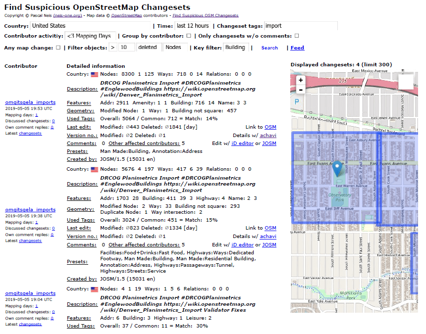
Monitoring Suspicious Building Imports by Country / Region 1 | Pascal Neis under CC-BY-SA 3.0
Cards
- Museos Abiertos is a non-profit organization that works to “discover” the heritage of museums. It helps both government and private organizations to effectively manage their values and digital archives. Not long ago, Museos Abiertos published a map of the museums of Buenos Aires (Argentina).
- Jasebi made a request to display on the main OSM (Catro-CSS) filesystem of ridges and peaks . Nothing has yet been decided, but discussion and ideas may be useful to anyone interested in mountains and countryside.
- The Association of Rail Operators of Great Britain ( National Rail ) has developed a map of rail station accessibility for people with disabilities. OSM is used as a substrate.
- In Belgium, four public transport operators jointly developed the Smart Mobility Planner (Smart Mobility Planner), which takes into account the information transmitted in real time by each of the operators when building the route. Routes are built on a map that is based on OSM.
Mapping
- Started voting for the
camp_site=camp_pitch, which was proposed by n76 exactly four years ago. This tag is proposed to mark places for tents and caravans on the territory of campgrounds. - The user amilopowers suggests using tags
surface=whispering_asphaltorsurface=silent_asphaltmark a special type of asphalt (“whispering”), which would allow to estimate the level of noise pollution on the roads. However, most commentators on the Tagging mailing list find it better to use other tags for this, for example,asphalt:type=*,asphalt=whisperornoise_reducing_surface=yes. - In iD, a tag appeared for what is forbidden in most countries:
shop=cannabis. - Changing tables for changing tables (
changing_table=*), developed by Velor Naram, received an ambiguous assessment after it was voted on.
Software
- Bryan Housel announces that in the next version of iD, users will not be able to delete items with the wikidata tag. This is explained by the fact that inexperienced users often delete the necessary data without realizing it. This simple “Security Lock” can be circumvented by removing the
wikidata=tag first. - Fabina Kowatsch has already published the fifth issue in the series of instructions on the OHSOME platform, designed to analyze the history of edits in OSM. Developed by the Big Spatial Data Analytics team for analyzing large spatial data at the University of Heidelberg
- [1] Pascal Neis, in a discussion on building quality, announced the possibility of detecting OSM-suspicious buildings in your country / region. To monitor the import of buildings, you can filter by comment
importand filter forbuilding.
Programming
- This year at Google Summer of Code from OpenStreetMap took 5 projects :
- Jason Manoloudis (Iason Manoloudis):
3D OSM2World - Thomas Hervey :
HOT - Tanya Haddad :
Wikidata Nominatim - Vishal R:
3D - Ashish Singh :
PT_Assistant ( ) JOSM
- Jason Manoloudis (Iason Manoloudis):
- Simon Poole writes (automatic translation ) in his diary about potential problems for mapping applications with the introduction of a special Google repository.
- Ilya Zverev writes in his blog about the rise and fall of the program for building routes OSRM, in which Mapbox stopped investing, after the Valhalla development team came to his place a year ago.
Programs
- Published update for Overpass-API, which fixes security issue. It is recommended to install the update immediately. Public servers have already been updated.
- Simon Poole has written background information about MapSplit and its format, which is used for improved autonomous work of Vespucci 13.0 - OSM editor for android.
- A Wambacher member is always happy to provide information on new versions of OSM programs .
Do you know …
- ... to please Christopher Beddow , Pascal Nays added the Deriviste editor to the OSM member statistics “ How did You Contribute ”.
- ... about the appearance of Harry Potter Wizards Unite is a new game with augmented reality from Niantic , the creators of Ingress and Pokémon Go . Pokémon Go has become known in the OSM community as the cause of constant questionable edits, because it used OSM data for maps and game data. These edits were mostly parks added by gamers in the hope of increasing the number of Pokemon creatures in the correct terrain (the so-called 'spawn rate').
- ... about the site cycle.travel by Richard Feyhurst? This is a website for cyclists, using
surface=tags or other OSM data related to bike rides to make them as useful as possible. - ... are there different tags for battery recycling devices (
recycling:batteries) and car batteries (recycling:car_batteries)? And what about 70 different things that can be recycled are described in our wiki?
OSM in the media
- The Internet portal Infofunes.com.ar published (automatic translation ) an article about Franco Benedetti ( @mweper ) from the small Argentinean town of Funes , which, while riding a bicycle, makes his map in OSM more accurate. In this, he is helped not only by Mapillary panoramas, which he himself shoots, but also by Wikipedia.
Other “geo” events
- Pascal Nais uploaded all his OSM presentations (most of them are in German) on GitHub .
- The online magazine Entre-Temps spoke about the work done by the Old Maps Online portal on digitizing and geo-referencing historical maps from libraries around the world, which they have been conducting for the last 10 years. They managed to find and digitize not only old maps of many cities, but also such "diamonds" as the Mumoldus Mercator's " Orbis terrae compendiosa descriptio " (1587).
- Guy Shrubshol from Friends of the Earth (UK) wrote a book on land ownership in England - “Who owns England” ( The Guardian review ). For several years, he was in his blog talking about the details of the study, which in the end is easily the basis of this book. For example, not so long ago, he drew attention to the fact that almost 17% of the country's territory is not registered in the Land Registry (cadastral authority in the UK).
- May 2 marked the 500th anniversary of the death of Leonardo da Vinci . He drew maps and plans of cities, as if he saw them from the air, for example, in 1502 he performed the Imola plan in this style. In a small film from VOX, it tells in detail how he did it.
Community
- The founder of the OSM office in Ghana Enok set Nyamador enrolled in the master's course in GIS technology in Munich. Unfortunately, he failed to get a scholarship to the Erasmus Mundi program, and now he is trying to raise funds for his education through the crowdfunding platform Go Fund Me .
- UNAM Mexican TV channel interviewed OSM-Mexico community representatives Miriam Gonzale and Celine Zhakin.
- Valery Trubin began a series of interviews ( 1 , 2 ) with Russian mappers. He is interested in how they came to OSM, how they see his future and that they want to change in this project.
- At the end of April in Russia there was a cartographic action "Spring entrances" . For one week, its participants noted the entrances to residential apartment buildings, as well as their rooms and apartment numbers in them. As a result , almost 1.5 thousand entrances were added to OSM.
- A researcher from Northwestern University in Evanston, Illinois, Matthew Das, at the ACM CHI 2019 conference held by the Computing Technology Association , spoke about his work on gender analysis of the contribution of OSM participants in the United States. They analyzed the edits of the 2 thousand most active users who marked or edited the POI. Depending on the specifics of the POI, the information entered was related (in the author's terminology) to either “masculine” or “feminine”. Previously, where it was possible, the gender of the participant was determined. As in other papers, it was concluded that 95% of OSM users are male, but it cannot be said that the information entered is determined by the influence of gender.
- At the end of April, a paper atlas of the city of Pokhara (Nepal) was released , which was prepared using data from OpenStreetMap, as well as the Geonode web portal (project Secondary Cities - 2C). With the support of the 2C Pokhara project, Kathmandu Living Labs (KLL) collected data on the ground. KLL also interacted directly with the local administration, which made it possible to add quite a lot of POIs related to health care, water supply, education and business.
Imports
- Robert Bell ( Itsamap member ! In OSM and bjjptq in Reddit) gives a very detailed description of how they accessed local data and then imported it into OpenStreetMap. Persistence and dialogue with local officials (especially in the GIS department) was the key to this. In addition, many detailed tips are given on how to structure the data before importing.
OpenStreetMap Foundation
- The minutes of the OSMF meeting on April 24 were published , with the exception of the closed paragraph on GlobalLogic.
Developments
- Srikar Arepalli is looking for speakers who are ready to talk about OSM at the VNR GNU / Linux conference, which will be held in India in July (Hyderabad).
- This year's SotM Africa conference will be held from 22 to 24 November in the city of Grand Bassam (Côte d'Ivoire). Terms:
- Until May 20 - accepting applications for scholarships ;
- Until May 31 - reports .
- On May 14, at the ESA Living Planet Symposium, two tasks will be presented and launched on the TeachOSM platform, which are related to climate change, sea level rise and deforestation.
- OSM France Foundation has published
 the program of the annual general meeting, which will be held this year in Montpellier at the SotM France 2019 conference. Until June 1, nominations to the General Council and the receipt of applications for speeches.
 - The Austrian OSM community participated in the Maker Faire Vienna 2019 exhibition. About how it was, told one of the participants in his blog (the first day - the translation , the second day - the translation ). By the way, he is a geologist.
- On May 29, the first cartoton will take place in Saarland (Germany). It will be organized by OpenSaar , “Doctors Without Borders”, the project of the Erasmus + program in the Gäschwister -Scholl-Schule Saarburg Technical Lyceum - euYoutH_OSM . The action will be held on the eve of the conference LGM2019 . Registration is required to participate.
Humanitarian OSM
- Cuo-yu Chuang spoke about the HOT and Missing Maps organizations to hundreds of participants in one of the largest cartatons ever held in Taiwan.
- Melanie Ackle from the University of Heidelberg GiScience Research Group spoke at a conference on early warning of catastrophes (May 13-14), where she spoke about the experience of Missing Maps and services related to disaster analysis developed by the university.
- During the past months, the HOT team has been studying the workflows of mapping and checking information in the Tasking Manager in order to prepare it for a big update. Planned introduction of machine learning, which would entail an even greater use of open data. In the HOT blog, Leila Pinho talks in detail about how they work to improve the quality of data, increase the speed of mapping and increase the percentage of users who are willing to participate in a project regularly.
Open data
- The UK Ministry of Industry supports a local government initiative to make transport data more accessible for various purposes. One of the transport providers, Nottingham City Transport, recently announced the opening of a data set to achieve this goal. Along with their own data on bus routes, stops, schedules and tickets, they also provide the extraction of OpenStreetMap data (in XML format) related to their route network.
Licenses
- In response to our last week’s article on Oracle licensing changes in Java, JOSM developers published a statement explaining that nothing has changed for the free Java version, OpenJDK or Oracle JRE 8. Therefore, licensing changes do not affect JOSM and the developers recommend continuing to use the current version Java, apply any updates and wait for the publication of OpenJDK, published by the community, which will be available on each platform.
')
Source: https://habr.com/ru/post/451532/
All Articles