News from the world of OpenStreetMap №458 (04/23/2019-29.04.2019)
Castles and palaces of Switzerland, including neighboring countries, Germany, France, Italy. The combination of OpenStreetMap + Wikidata + Wikimedia Commons + Wikipedia 1 | Data Members OpenStreetMap, ODbL
Cards
- At the Pacific Visualization conference, Jochen Gertler, along with his colleagues, won the Best Paper Award for his work “Stippling 2D Scalar Fields” (mostly maps).
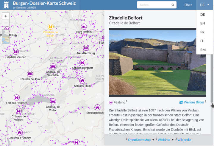
- [1] Stephen Keller of Rapperswil University of Applied Sciences published the Map of Switzerland Castles. Currently, this is the most complete web map of castles and palaces in Switzerland, including nearby countries (Germany, France, Italy) - right up to Neuschwanstein Castle. A multilingual web application uses data from OpenStreetMap, Wikidata, Wikimedia Commons (images) and Wikipedia. Project source code is available on GitLab.
- The historic.place service has been updated and is now showing a new map of castles in Switzerland based on data about Wikimedia castles
 .
. - The official application of the London Marathon surprisingly used tiles from the OpenStreetMap server, which did not cope with the load (probably due to the incorrect configuration of their CDN). See also tile policy and switch2osm.org as tutorials on customizing your own infrastructure.
Open data
- The German branch of the Open Knowledge Foundation reports on EU 2018/0111 new guidelines: reuse of public sector information that will facilitate access to public information. The new guidelines apply to public sector companies, state that any EU documents should be “open in design” and “open in default” and provide further improvements. However, the EU still lags far behind the domestic ban on copyright protection, which benefits the work of the US government.
Licenses
- Oracle is changing the licensing model for the Java platform. How it affects the use of JOSM is discussed in the German forum (automatic translation ).
Software
- Development Seed has created osm-coverage-tiles that visualize infrastructure information, in particular, buildings and roads from OSM, to improve the validation of machine learning results. Pilar Gabriela Serrano Quispe (Pilar Gabriela Serrano Quispe) gives additional information in an article on medium.com
Programming
- Pierre Béland released PostGIS OQ_Analysis , which he used to analyze the quality of building mapping.
OSM in the media
- The Saarbrücker Zeitung website writes about Carsten Grams, a board member of a private association that cares about preserving mining history in the Saar. With excursions through the old tunnels and work on the Historic Map Historic. Place and OpenStreet Map, he combined both hobbies and now conducts excursions
 / in the mine adventure velsen.
 - The article on apnews.com describes how they combined and analyzed data from the US Census Bureau, Cal Fire and OpenStreetMap to assess the evacuation routes of Californians living in areas where there is a risk of fire.
Mapping
- On April 26, there was a daily rally on drawing Lesotho (a country in South Africa), which was organized by the winner of the "Best Cartographer" award in 2018 Tshedy (Mathseliso Thobei). In her Twitter, she thanks all the participants for their support and thanks. The action was carried out in order to improve the quality of the map of this state.
- Colin Blackburn reports that he kept his word and surveyed one territory in the Netherlands, which was called "Clothing is optional." He notes that he did not find any evidence that this place was so called.
- Now there is a vote for the new tag
landcover=barren, which is proposed to mark the territory without vegetation and with bare soil. However, by this time, the majority voted against its introduction. It is quite possible that the comment by Peter Elderson, which he left to his voice, explains the reason for this reaction: "... your thinking [of the one who proposed the new tag] does not correspond to the opinion of the majority of OSM participants" . - The voting began for the key
golf_cart=*, which proposes to designate the possibility of passing golfcars or similar small non-speed electric cars. - Joseph Eisenberg added a new section to the “Verifiability” wiki article about unconfirmed geometries , such as
natural=bay(bay),natural=strait(strait) andplace=*. However, not everyone supported this initiative, for example, Tobias Knerr opposed. - Instead of starting the process of discussing the new tagging scheme, Joseph Eisenberg immediately created a wiki page for
natural=mountain_range, because he thought that the tag was already used in OSM. At the moment, almost 80 cartographers have used it, and have marked over 600 objects with it. - Joseph Eisenberg created a page for each of his proposed new tags:
natural=mesaandnatural=butte. Mesa is a geological formation, also known as a plateau, potrero or tepui. Butt is something similar to mes, but somewhat smaller in size. - Jan S. voted on a shortened version of the “Police Institutions” tagging scheme, which was rejected not so long ago. Now it consists only of the
police=*tag. - Fanfouer proposes to introduce new keys for traction substations (
substation=traction) in order to better describe their purpose, and therefore is waiting for comments. - Anna and Karen from the University of Geography at Heidelber University decided improve the map of Heidelberg so that participants in the State of the Map conference in September 2019 can navigate around the city and build the right routes in OSM. They plan to clarify accessibility information, add entrances to various buildings and on site. It would not be Germany, if the very first reaction to this message would not be a proposal to abide by the rules. By the way, for coordination of actions created wiki page
- It turns out that the differences between
waterway=riverandwaterway=canalnot as obvious as one might think. Dave F. began to discuss this issue, since he considered that other cartographers incorrectly mark the channelized sections of the rivers near the locks aswaterway=canal.
Developments
- Adam Steer (Adam Steer) shared information about the proposed FOSS4G SotM Oceania program, which will be held November 12-15, 2019 in Wellington, New Zealand, and asks for comments before the end of May, when the presentations and seminars should begin.
- The reception of topics and reports for FOSS4G UK, a conference on free and open geospatial software, is now open. The conference will be held in Edinburgh on September 19-20, 2019.
Programs
- The JOSM team has released a new stable version. In version 15031, a bug was fixed , due to which the comment to the group of changes was loaded, despite the empty comment field to the group of changes with the last one used. The download_along plugin functionality has been added to JOSM and is now available in the Additional Tools section. As always, there are many other improvements , fixes and new features.
Do you know …
- ... about tags for schedules at public transport stops? The traditional schedule placed at the bus stop can be tagged as
departures_board, since the new electronic scoreboard with relevant information is marked with thepassenger_information_displaytag. - ... now you can quickly add a motion restriction relationship with the editors of Vespucci or iD ?
Other “geo” events
- Daniel Huffman recalls LineDrive linear cartograms and publishes a link to his old post.
- The Far & Wide website presents some interesting facts on world maps.
- An article in the Wired magazine explains the difference between geocodes and addresses using the example of operations after a hurricane in Puerto Rico.
- From 14 to 17 May, the OSGeo community holds a sprint, which will be held in Minnesota, USA.
Community
- Fanevanjanahary and SeverinGeo posted a snapshot of one of the #ActionOSMMG2019 workshop held in Antananarivo (Madagascar) in mid-April on Twitter. # ActionOSMMG2019 is a two-week course in OSM and open geomatics for students, as well as business and local government representatives. They were organized by members of the Chadian community and Togolese cartographers with the support of the Francophony International. Also, during the training, a multi-day campaign was held on the drawing of the territory near Lake Itasi , which was held in the framework of the decentralized cooperation “Itasi / New Aquitaine”. All of this is documented in WikiOSM accordingly, following the principles of organized editing of the OSM Foundation.
- Shoreline and ice cover uploads previously posted on openstreetmapdata.com have been transferred to osmdata.openstreetmap.de . Jochen Topf in his blog talks about the reasons for the "move".
- The Talk-us mailing list contains a broad discussion of the differences between park types, as well as the meaning of the word "park" in the tags
leisure=parkandboundary=national_park. - Ginal Foflia from Grab recently reported on her blog that their team in Thailand is currently working on uploading images of areas around Chiang Mai to Mapillary. On April 26, they uploaded 82% of the images, which cover 1,667 km of roads. They planned to complete this work by early May.
- Within the framework of the Opencities Africa project in Kinshasa (the capital of the Democratic Republic of the Congo), since June 2018, various measures have been taken to increase the resilience of territories to erosion and flooding. These included methods related to mapping: drones, training in data collection using phones and tablets, conducting focus groups for analyzing maps and identifying problems; study of tools for analyzing the quality of mapping. The project was organized by the World Bank, Potentiel 3.0 and the local OSM community in the Democratic Republic of the Congo together with OSFAC ( video in French ).
- The removal of articles from WikiOSM remained unregulated. The proposal to introduce the relevant rules was not supported . One of the main remarks: along with the rules, complex bureaucratic procedures will appear that only delay the process of deleting articles. Although some of those who opposed this version of the rules, still recognized the need for rules of removal in one form or another. It is possible that over time and an increase in the number of obsolete articles, this question will arise again. In the latest issue of WeeklyOSM, we already talked about a noticeable complaint about a remote page on WikiOSM.
- flowolf and his colleague began creating a free OSM-based business directory (Yellowosm). This was reported in the conversation on Grazer Linuxtage 2019. At the moment, only Austrian enterprises are shown on the map.
Humanitarian OSM
- In a blog on the HOT website, Lauren Bateman of the American Red Cross tells how data and maps provided by HOT and OpenStreetMap helped eliminate the effects of the cyclone Iday.
- On May 23, 2019, the University of Luxembourg and the humanitarian organization Doctors Without Borders held a mapping campaign to assist in the work of the latter.
- The network posted the minutes of the meeting of the HOT Board of April 18, 2019.
- The MapSwipe community and the Heidelberg Geo-Information Technology Institute have begun work on expanding MapSwipe, which will allow users to detect changes by comparing two satellite images. This is supposed to help with humanitarian mapping.
- The GIScience University Research Group of the University of Heidelberg (30.04-03.05) at the 11th Conference on Information and Communication Technologies for Development (ICT4D) in Kampala (Uganda) held a session entitled “Using and analyzing OpenStreetMap for development” .
')
Source: https://habr.com/ru/post/451176/
All Articles