How to coordinate the flight of the probe into the stratosphere (with what we face in practice at launch)
On April 12, we are going to launch a stratospheric probe with a small server, from where our page will be transferred to the CDN below. Incoming channel - low-orbit communications satellites, outgoing - radio stream at amateur frequency frequencies (telemetry and control) and Wi-Fi (video and data).

The problem with the launch is that it is an unmanaged aircraft. In a sense, this is just a balloon with helium, to which several kilograms of iron are attached. And this is important, because this iron can knock on someone's plane or fall on someone's territory. Municipalities, for example, do not like it when it falls on the territory of its facilities. Preserves too. And Rosatom really doesn't like it at all.
There will be a camera on board, that is, it will be an aerial survey. Permission for it must be obtained from the Federal Security Service.
')
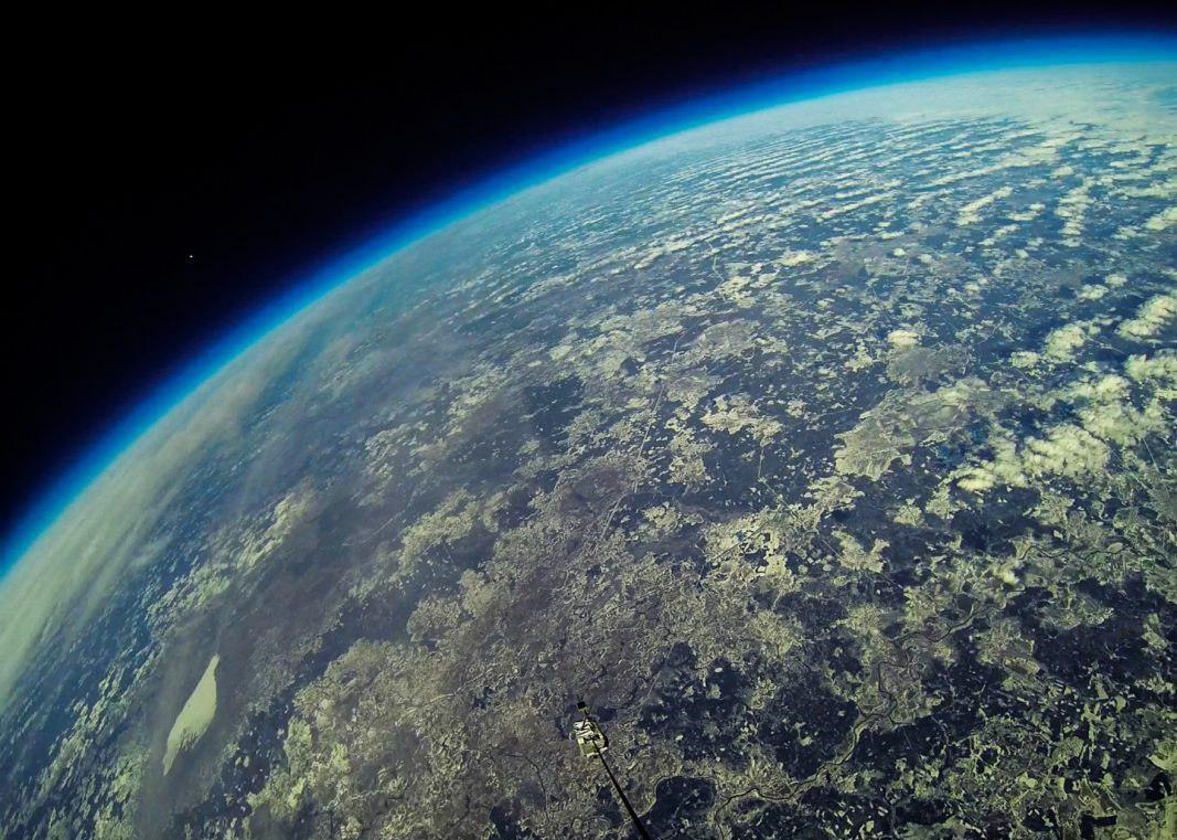
This is a peak flight, that is, we rise to a working height, quickly carry out the mission and descend to land. The probe usually takes 100-150 kilometers from the starting point in the direction of the wind blowing at a height of up to 30 kilometers from the ground. Turbulence usually disappears above 20 km, and the air density there is 100 times less (you can see the characteristic boundary of the atmosphere on the photo), so the flight there becomes smoother. We can even fly to Vladivostok, but the larger the trajectory, the more difficult it is to obtain official approval of the flight, which makes us reduce the flight as much as possible.
This is what this flight looks like, 99% of the entire Earth’s atmosphere is already below our stratospheric platform:

The first thing we do is look for a place where 150 kilometers of flight in the “approximately that” direction downwind will be the easiest to reconcile. To do this, go to the fpln.ru site (by the way, it works on OpenStreetMap) and look for a place where a minimum of approvals is required:

As a rule, this means that it is necessary to get out of Moscow - to go beyond the zones of airports, various military facilities, and generally dense development. I want to start not from the city (this will reduce coordination) and certainly land in the field, or at least in the forest for the same reason. It would be good if there was nothing at the point of landing that would force us to search for a probe with a payload of more than 5-6 hours.
If this is your first approval, then get ready for a very long quest with official documents. Some approvals can calmly take up to a couple of months. We do the following to reduce risks:
The flight plan of the unmanaged vehicle to the immediate departure is a sector. From the point of view of the logic of coordination, the device can be located at any point of this sector at any moment of flight, therefore it is allocated exclusively for our flight for the entire declared time ...
With all the owners of the restricted areas on the map, you must go through the process of coordination. For example, if we fly over the reserve - get permission from them, if above the mentioned Rosatom - from them, and so on. Naturally, it is also necessary to coordinate with all the surrounding airfields. All aviation dispatchers who control the flight routes of airplanes also need to be warned.
3-5 days before the start, there is a weather forecast and winds, which you can believe, and you need to start coordinating the flight in the form of a fork of trajectories. This is not a zone of wide strokes with different starting points, but one starting point and the angle of spread from the wind. Sometimes these are z-shaped trajectories, sometimes circles or squares (depending on the specific weather and plan). But most often it is the starting point and angle.
 An example of drawing up an application for launching balloons and balloons
At this stage it is necessary to submit an application to the air traffic control center. This application allows or does not allow the use of airspace. Further they establish this or that mode of use and insert into the plan. This is if nothing confuses them. But the center may request additional coordination with neighboring areas, airfields, or with the General Staff.
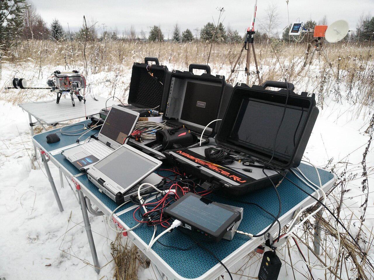
If everything is normal, then give preliminary permission for three days before the start. At this moment we are already starting to prepare our mini-PCO. This is how it looks like:
An hour before the start you need to call and clarify whether everything is fine. At this point, the flight plan for the center is compared with the actual weather (wind). Further three options are possible:
In addition to surprises with the weather on the day of the flight, unpredictable phenomena may occur, such as exercises at some military airfield. There is a priority in the use of airspace. Our probe is launched from a physical person, and a physical person has the lowest priority in comparison with government tasks, military tasks, passenger flights, and so on. If the military exercises, the center can say: "Well, I'm sorry, three aircraft flew into your square, nothing can be done." Periodically, on the launch of weather probes, intersections occur with the flying laboratory of the cosmonaut IL-76, where they train to work in weightlessness. Their priority is also predictably higher. We must wait for the completion of their flight.
We ourselves can unhook the load from the ball. Air traffic controllers may also request this at any time. This means that we give the command to the device, there the special device disengages the carabiner, and the ball itself soars upward (where it quickly collapses under pressure), and the load goes down under the parachute. This is necessary in case of sudden changes in wind and other incidents, when the danger of the ball moving in the off-design zone is much higher than the danger of landing in an off-site location. We very much hope that the result of the flight will not be something like "killed a cow by a router."

By itself, the ball is almost no danger, it is filled with inert non-flammable helium. But the load is heavier than a bird and flies above the bird, so it can be an unpleasant obstacle for airplanes, although so far we have not known a single incident of accidents involving the balloons. Naturally, we are trying to trajectory over sparsely populated areas in order to minimize possible troubles even upon landing.
Our start is likely to be in the Pereslavl-Zalessky area, where we have coordination with the FSB, the military, the airport, the zonal center and the owner of the starting field.
Here's what can interfere:
- Cloudy
There will be no problems with the launch, but there will be interference with the video broadcasting, since the clouds will dampen the signal (and we are limited in power and in the properties of the transmitters). The probability of dense clouds, we estimate at about 30%.
- Strong wind on the ground
This complicates the launch. 2 out of 100 launches fail because of this, or else you need to have spare probes in case the main wind breaks. A casual estimate is 20%.
- Precipitation (rain or snow)
Running in the rain or snow may cause a change in flight path. Rain on electronics or camera lenses can damage equipment or an image. A score of 20%.
- Sudden teachings or special flights
Depending on the work schedule of the nearest airfields, it happens that permission for one day is harder to get than another. Because of this, sometimes you have to postpone the start. The probability is below 20% by experience.
- Landing in a difficult place
Chance less than 10% with the current sector. But it is still possible to land in an inaccessible place that requires more than 1 day to select equipment. You need to get to the landing site, pick up equipment and download video from the board. So do not wait for the results immediately)
- “Redemption” of the probe
1 time had to pay the finder that he returned the equipment. 2 times gave for free. This happens in case of landing in the zone of visibility by unauthorized people, when they pick up the probe before us. That is why we arrange a hunt for a probe with a prize on the machines - so that we can catch him right on the telemetry even on the descent. The probability of 3% according to the statistics of 100 flights.
- Loss of equipment upon landing in an inaccessible place.
Of the 100 launched stratostats, 3 were lost due to a landing or landing at a place from which the equipment could not establish contact with the satellite and transmit its coordinates.
To reduce this probability, we try to ensure positive buoyancy of the payload and duplicate communication systems.
- Problems with the capacity of communication channels
On the day of launch in the approved location may not be sufficient speed available channels of access to the Internet. This applies to transponder capacity and broadcast video from the mini-MCC to you. On our stratostat we use two different communication channels. On the ground - all available bridge operators. Risk assessment is less than 10%.
- Loss of communication channel from the stratostat to the ground
Due to bad weather conditions or technical problems related to the harsh operating conditions of the technology in the stratosphere (temperature down to -70 ° C), broadcasting from the stratostat to the ground may stop. In this case, we all will be bored, but such is life. Risk assessment is less than 10%.
So we do not promise 100% of the show, but we are doing everything to make it work. The main thing - that the weather was. And with her, it seems (pah-pah) so far everything is in order according to the forecast, but you know how predictions are sometimes mistaken :).
We invite Habrazhiteley to take part in our experiment and fight for the main prize - a trip to Baikonur.

The problem with the launch is that it is an unmanaged aircraft. In a sense, this is just a balloon with helium, to which several kilograms of iron are attached. And this is important, because this iron can knock on someone's plane or fall on someone's territory. Municipalities, for example, do not like it when it falls on the territory of its facilities. Preserves too. And Rosatom really doesn't like it at all.
There will be a camera on board, that is, it will be an aerial survey. Permission for it must be obtained from the Federal Security Service.
')
This is a peak flight, that is, we rise to a working height, quickly carry out the mission and descend to land. The probe usually takes 100-150 kilometers from the starting point in the direction of the wind blowing at a height of up to 30 kilometers from the ground. Turbulence usually disappears above 20 km, and the air density there is 100 times less (you can see the characteristic boundary of the atmosphere on the photo), so the flight there becomes smoother. We can even fly to Vladivostok, but the larger the trajectory, the more difficult it is to obtain official approval of the flight, which makes us reduce the flight as much as possible.
This is what this flight looks like, 99% of the entire Earth’s atmosphere is already below our stratospheric platform:
The first thing we do is look for a place where 150 kilometers of flight in the “approximately that” direction downwind will be the easiest to reconcile. To do this, go to the fpln.ru site (by the way, it works on OpenStreetMap) and look for a place where a minimum of approvals is required:
As a rule, this means that it is necessary to get out of Moscow - to go beyond the zones of airports, various military facilities, and generally dense development. I want to start not from the city (this will reduce coordination) and certainly land in the field, or at least in the forest for the same reason. It would be good if there was nothing at the point of landing that would force us to search for a probe with a payload of more than 5-6 hours.
If this is your first approval, then get ready for a very long quest with official documents. Some approvals can calmly take up to a couple of months. We do the following to reduce risks:
- For the longest coordination (starting points, spans over large areas) we give a fairly large area and several starting points. If the wind suddenly changes from the expected, then it will be possible to change the starting point. For example, if it has changed by 20 degrees - it will be possible to move to a different start and make it so that the landing is exactly where we originally planned. With the starting point is the easiest to agree. In our history we will be launched from the field outside the municipal territory, so we simply agree with the owner.
- Laying a backup launch date, of course.
The flight plan of the unmanaged vehicle to the immediate departure is a sector. From the point of view of the logic of coordination, the device can be located at any point of this sector at any moment of flight, therefore it is allocated exclusively for our flight for the entire declared time ...
With all the owners of the restricted areas on the map, you must go through the process of coordination. For example, if we fly over the reserve - get permission from them, if above the mentioned Rosatom - from them, and so on. Naturally, it is also necessary to coordinate with all the surrounding airfields. All aviation dispatchers who control the flight routes of airplanes also need to be warned.
3-5 days before the start, there is a weather forecast and winds, which you can believe, and you need to start coordinating the flight in the form of a fork of trajectories. This is not a zone of wide strokes with different starting points, but one starting point and the angle of spread from the wind. Sometimes these are z-shaped trajectories, sometimes circles or squares (depending on the specific weather and plan). But most often it is the starting point and angle.
At this stage it is necessary to submit an application to the air traffic control center. This application allows or does not allow the use of airspace. Further they establish this or that mode of use and insert into the plan. This is if nothing confuses them. But the center may request additional coordination with neighboring areas, airfields, or with the General Staff.
If everything is normal, then give preliminary permission for three days before the start. At this moment we are already starting to prepare our mini-PCO. This is how it looks like:
An hour before the start you need to call and clarify whether everything is fine. At this point, the flight plan for the center is compared with the actual weather (wind). Further three options are possible:
- The weather was predicted well. Then we just fly.
- The weather is changeable, but the forecast fits. Then we have to transmit the probe coordinates to the dispatchers every few minutes by radio as we fly.
- The weather is predicted incorrectly. Flight is generally prohibited or transferred to another window (if it exists).
In addition to surprises with the weather on the day of the flight, unpredictable phenomena may occur, such as exercises at some military airfield. There is a priority in the use of airspace. Our probe is launched from a physical person, and a physical person has the lowest priority in comparison with government tasks, military tasks, passenger flights, and so on. If the military exercises, the center can say: "Well, I'm sorry, three aircraft flew into your square, nothing can be done." Periodically, on the launch of weather probes, intersections occur with the flying laboratory of the cosmonaut IL-76, where they train to work in weightlessness. Their priority is also predictably higher. We must wait for the completion of their flight.
We ourselves can unhook the load from the ball. Air traffic controllers may also request this at any time. This means that we give the command to the device, there the special device disengages the carabiner, and the ball itself soars upward (where it quickly collapses under pressure), and the load goes down under the parachute. This is necessary in case of sudden changes in wind and other incidents, when the danger of the ball moving in the off-design zone is much higher than the danger of landing in an off-site location. We very much hope that the result of the flight will not be something like "killed a cow by a router."
By itself, the ball is almost no danger, it is filled with inert non-flammable helium. But the load is heavier than a bird and flies above the bird, so it can be an unpleasant obstacle for airplanes, although so far we have not known a single incident of accidents involving the balloons. Naturally, we are trying to trajectory over sparsely populated areas in order to minimize possible troubles even upon landing.
Our start is likely to be in the Pereslavl-Zalessky area, where we have coordination with the FSB, the military, the airport, the zonal center and the owner of the starting field.
Are we going to launch exactly on a cosmonaut day? Not.
Here's what can interfere:
- Cloudy
There will be no problems with the launch, but there will be interference with the video broadcasting, since the clouds will dampen the signal (and we are limited in power and in the properties of the transmitters). The probability of dense clouds, we estimate at about 30%.
- Strong wind on the ground
This complicates the launch. 2 out of 100 launches fail because of this, or else you need to have spare probes in case the main wind breaks. A casual estimate is 20%.
- Precipitation (rain or snow)
Running in the rain or snow may cause a change in flight path. Rain on electronics or camera lenses can damage equipment or an image. A score of 20%.
- Sudden teachings or special flights
Depending on the work schedule of the nearest airfields, it happens that permission for one day is harder to get than another. Because of this, sometimes you have to postpone the start. The probability is below 20% by experience.
What can happen in flight and on landing?
- Landing in a difficult place
Chance less than 10% with the current sector. But it is still possible to land in an inaccessible place that requires more than 1 day to select equipment. You need to get to the landing site, pick up equipment and download video from the board. So do not wait for the results immediately)
- “Redemption” of the probe
1 time had to pay the finder that he returned the equipment. 2 times gave for free. This happens in case of landing in the zone of visibility by unauthorized people, when they pick up the probe before us. That is why we arrange a hunt for a probe with a prize on the machines - so that we can catch him right on the telemetry even on the descent. The probability of 3% according to the statistics of 100 flights.
- Loss of equipment upon landing in an inaccessible place.
Of the 100 launched stratostats, 3 were lost due to a landing or landing at a place from which the equipment could not establish contact with the satellite and transmit its coordinates.
To reduce this probability, we try to ensure positive buoyancy of the payload and duplicate communication systems.
- Problems with the capacity of communication channels
On the day of launch in the approved location may not be sufficient speed available channels of access to the Internet. This applies to transponder capacity and broadcast video from the mini-MCC to you. On our stratostat we use two different communication channels. On the ground - all available bridge operators. Risk assessment is less than 10%.
- Loss of communication channel from the stratostat to the ground
Due to bad weather conditions or technical problems related to the harsh operating conditions of the technology in the stratosphere (temperature down to -70 ° C), broadcasting from the stratostat to the ground may stop. In this case, we all will be bored, but such is life. Risk assessment is less than 10%.
So we do not promise 100% of the show, but we are doing everything to make it work. The main thing - that the weather was. And with her, it seems (pah-pah) so far everything is in order according to the forecast, but you know how predictions are sometimes mistaken :).
We invite Habrazhiteley to take part in our experiment and fight for the main prize - a trip to Baikonur.
Source: https://habr.com/ru/post/446300/
All Articles