Obtaining permission to fly a drone (UAV, UAV) in the Russian Federation in 2019
Obtaining permission to fly a drone (UAV, UAV) in the Russian Federation.
On the example of the Kaliningrad region
I am especially grateful to Aleksei Alekseevich Simanovich, Head of the EC Center for ATM, Kaliningrad ATS Center of the Branch “Air Navigation of the North-West” of the FSUE “State ATM Corporation” for their constant readiness to help and provide the necessary information. I would also like with great pleasure to note the high professionalism, serious and attentive attitude of all employees of the FSUE “State ATM Corporation”.
Two years ago, I described the procedure for obtaining permission to use airspace in the Russian Federation for UAVs. Read this article here.
')
The new article was built on the basis of the latest data and was supplemented with various useful information. In my opinion, it will be useful not only to ordinary owners of radio-controlled toys, model aircrafts and vehicles, but also to officials and officials, since I am going to touch on some problem areas in the current legislation of the Russian Federation, which have long been demanding their solution.
I paid special attention to the subject of photo and video filming from the air. Few people suspect what kind of legislative incident lies in this issue. This topic is discussed at the end of this article.
The main purpose of obtaining permits for the use of airspace (TIR) for a drone, unmanned aircraft (UA) (radio-controlled model aircraft), is to ensure a safe TRS - to exclude the possibility of a collision between aircraft, with other aircraft objects and just on the heads of citizens.
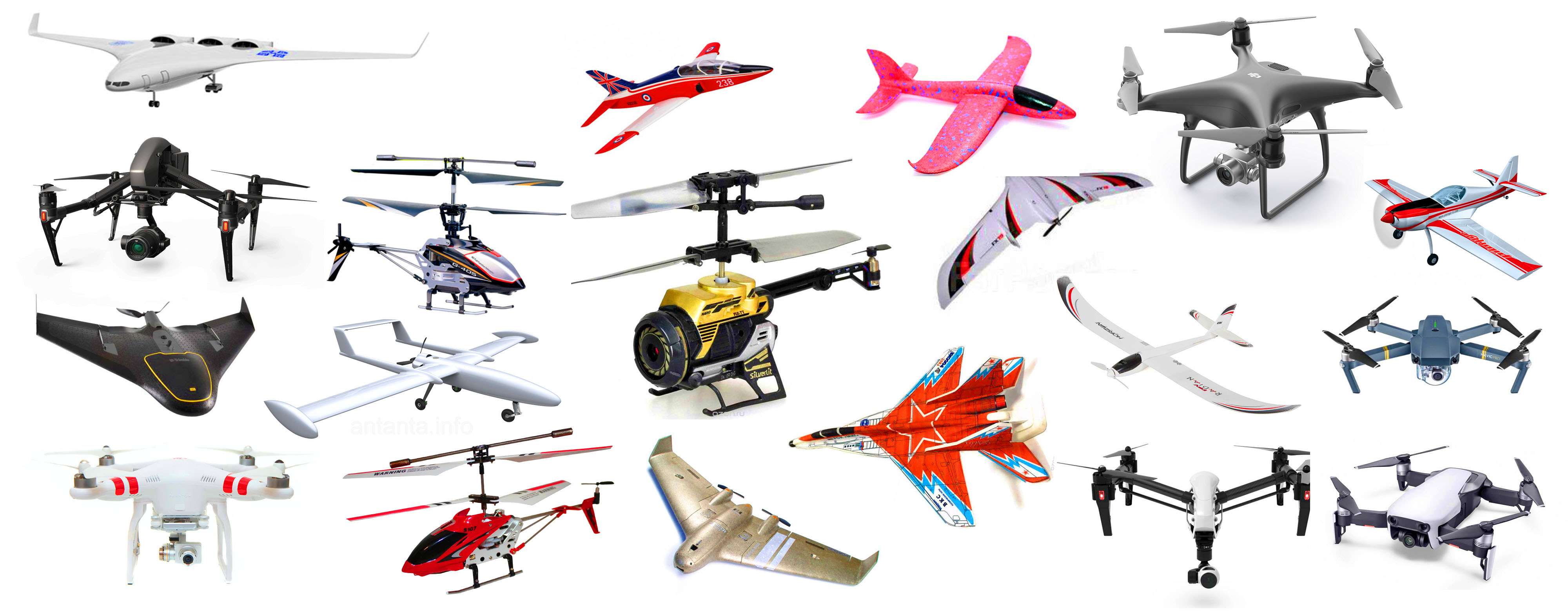
Most of the serially produced drone company DJI have a software limit on flight altitude, equal to 500 meters. But this does not at all exclude the likelihood of creating an emergency for civilian and military aircraft that are taking off or landing or flying at altitudes below this altitude mark. Many experts note that a possible collision of a passenger plane with a drone is much more dangerous than with a bird of similar mass and size. It takes into account the tendency of lithium-polymer batteries, which are used in the BVS, to instantly ignite during mechanical damage, during combustion of which high temperatures are reached. This is especially important in the event that the UAV parts get into an aircraft engine damaged by a collision, which can have serious consequences. Engineering analyzes based on computer calculations show that a drone with a take-off weight of more than 3 kg. can cause damage to the blades of the turbofan fan of the aircraft. In this sense, the need to pre-exclude the probability of a BAS collision in airspace with different aircraft is especially important, with the purpose of which permission is issued for the TTI at which action, a part of the airspace is allocated to one user, and other aircraft are prohibited from being in this zone.
This article is in fact a user guide for obtaining permission for a TIR in the Russian Federation for BVS. Hereinafter, different terms and abbreviations are used, in essence, meaning the same thing - drone, UAV (Unmanned Aircraft), UAV (Unmanned Aerial Vehicle).
The main part of the article, actually describing the process of obtaining permission for a TIW, will often be accompanied by various explanations and additions, without which it is impossible to state the text in a way that is understandable to the reader. Therefore, at the end of the article, I briefly, point by point, describe once again the whole necessary procedure for obtaining permission for a TTI for two cases - for temporary and local regimes.
To begin with, remember that without exception, drones, radio-controlled models and toys, UAVs perform flights:
1. When the temporary or local use of airspace is established for them;Existing airspace classes have no effect on these requirements in any way. There is also no range of heights in which, allegedly, you can fly without observing these two points. For all drones, radio-controlled models, BVS, a permissive (not notification) procedure has been established.
2. If there are conditions on the TTI issued on the basis of a flight plan submitted by the user.
In order to be able to legally use any radio-controlled model aircraft in the open air (drone, quadcopter, helicopter, airplane, etc.), it is necessary to obtain a permit for the TTI. Such requirements have existed for at least 19 years. Based on the current legislation of the Russian Federation (at the beginning of 2019), there is absolutely no difference what weight the model or toy has, and also at what height it is planned to fly.
For several years, many media outlets have persistently tried to confuse their readers, carrying out a one-sided presentation of information and stubbornly keeping silent about the most important points. It is about take-off weight from 0.25 to 30 kg. inclusive and more than 30 kg., respectively, accounting or registration of UA. All this information has nothing to do with the resolution of the TIW and the media did everything so that many people thought that once the drone did not need to register or register, then you can fly freely.
In fact, many media outlets disseminated useless information on the assumption that the emphasis was not at all where necessary.
However, everything in its place puts Art. 33 of the Air Code of the Russian Federation, which determines which UAs are subject to registration, and which accounts. Currently, there are no legal consequences for the lack of citizens' registration / registration of UA. The state registration is getting the UAV into the register of civil aircraft, while the FSUE “ZashchitaInfoTrans” of the Ministry of Transport of the Russian Federation is still developing the accounting system. FSUE ZashchitaInfoTrans is planned to be determined as the sole contractor within the framework of measures for the development, creation, development, modernization and maintenance of the functioning of the State Database on UA. The state database of UA will be maintained by the operator of accounting in electronic form.
For a flight without a permit to the TTI, responsibility is provided for under art. 11.4 of the Administrative Code (for individuals, a fine of up to 5,000 rubles, up to 50,000 rubles for officials and up to 500,000 rubles for legal entities) and this should be worried about by all owners of radio-controlled model airplanes, drones, and not the absence of accounting or registration of UA .
As an example, I will consider my case of obtaining a TIR permit for a personal UAV in order to carry out high-altitude flights (to an altitude of up to 5,000 meters) near the city of Kaliningrad, in the Kaliningrad region. In fact, regardless of the altitude of UAV flights, the procedure for obtaining permission to fly remains the same. There is a slight difference in establishing the temporary and local regime, but it is insignificant. This will be indicated below.
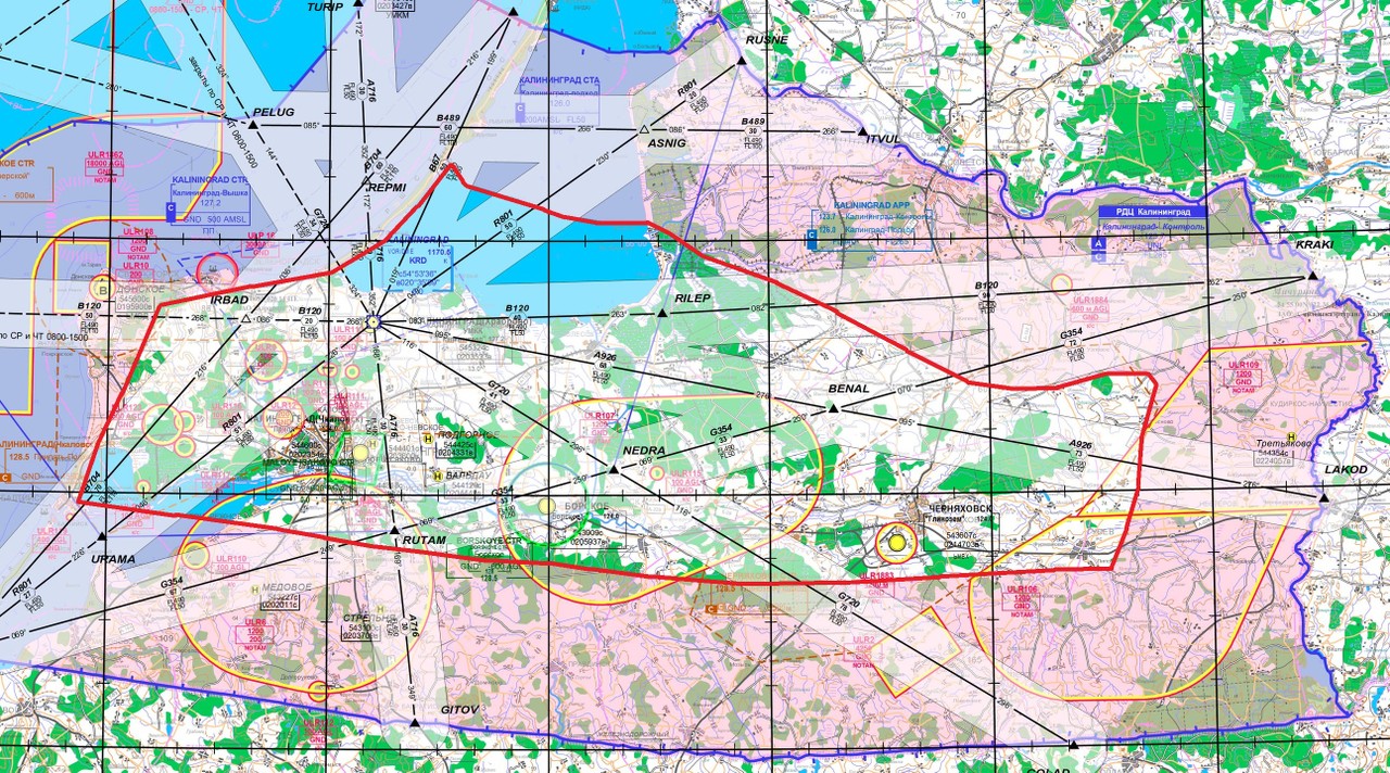
So, you plan to launch your drone, blu in some place. To begin with, you should make sure that the planned take-off-flight-landing site of the UAV is outside the restricted areas and restricted flight zones. To do this, you can open a website that displays the current state of the airspace of the Russian Federation, airfields and zones. By pressing the first button on the left at the top, you should turn on the display of prohibited zones and zones of flight restrictions (“ZONES” tab). Selecting the desired zone, you can see in whose interests it was installed and additional information about it, which are in the tabs. If it is necessary to fly within such zones, you should obtain permission from the persons in whose interests such zones are established.
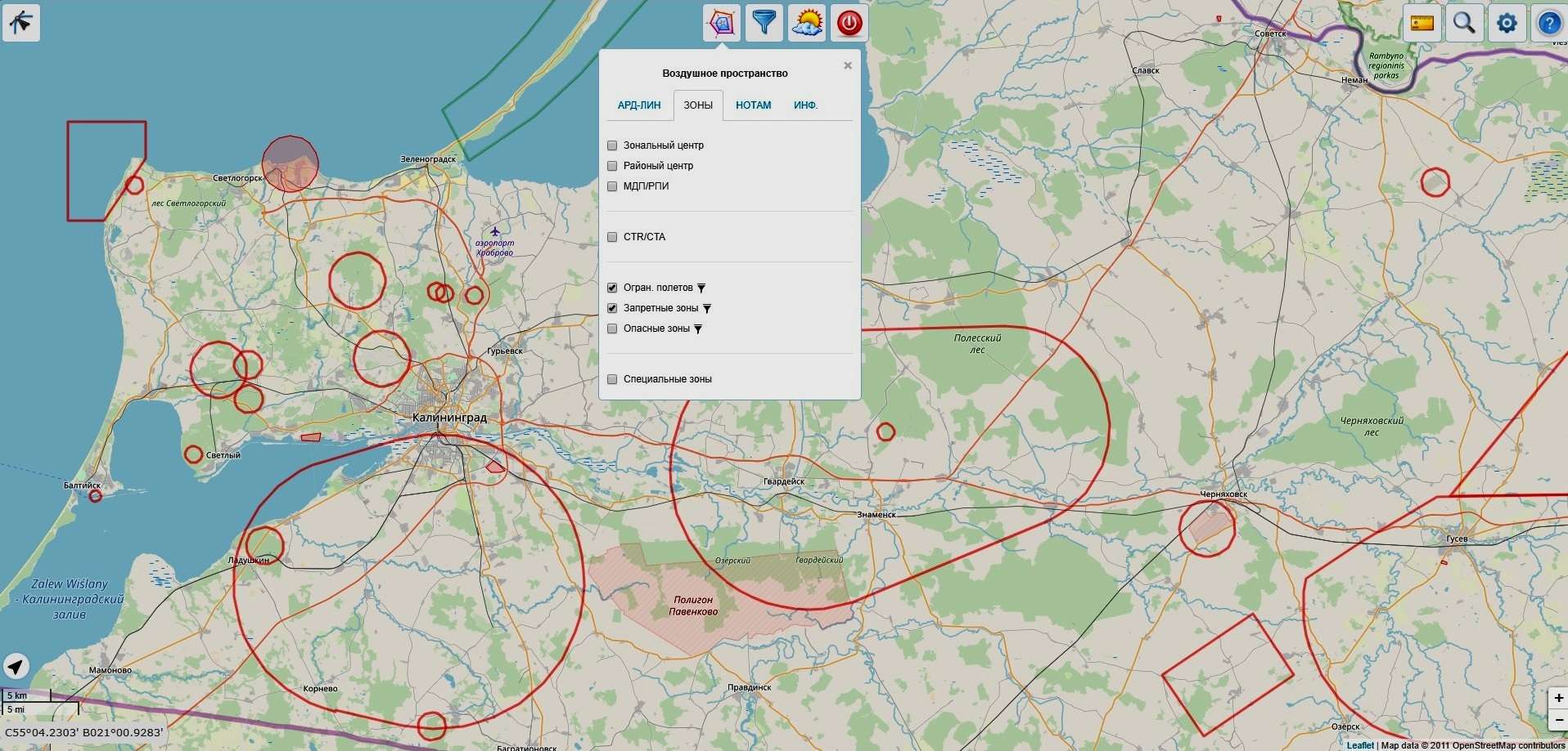
The presence of such zones can be seen on a special map:
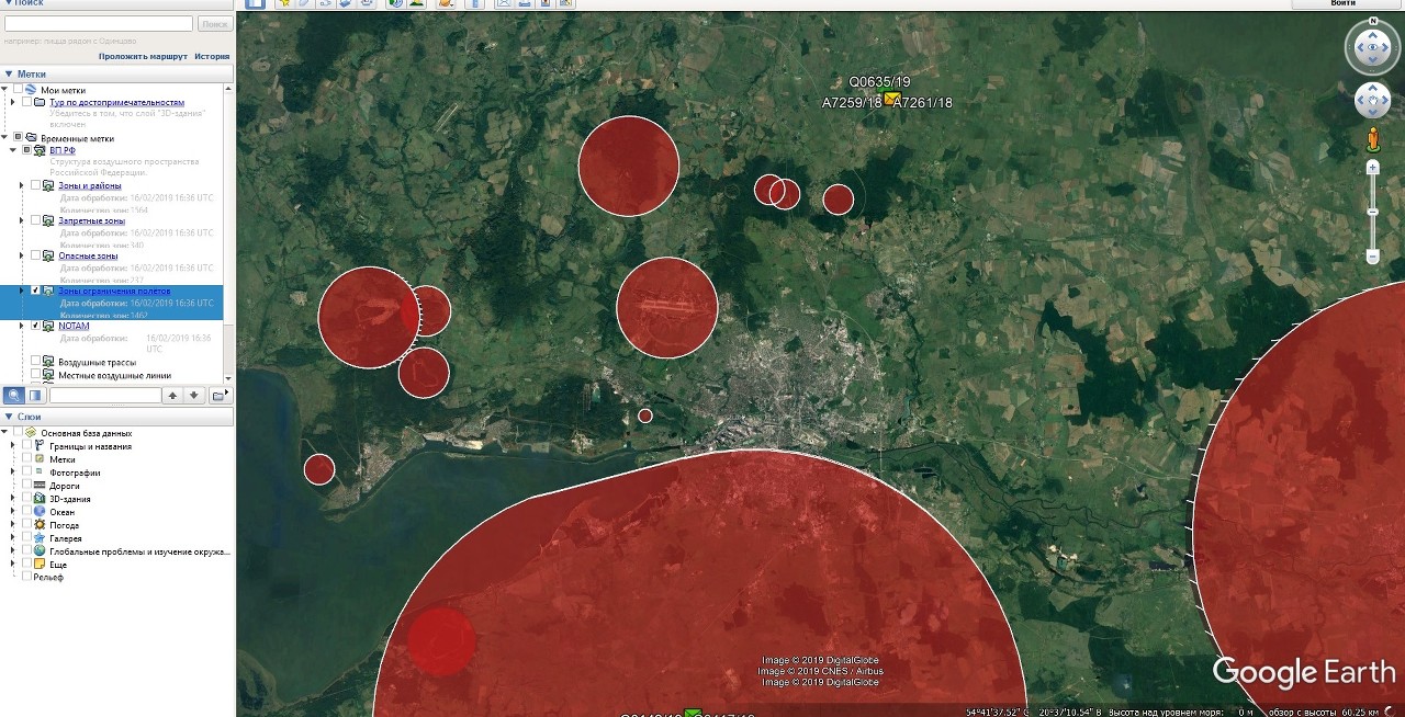
There is another option to view different zones and other information related to the airspace of the Russian Federation, including NOTAM (NOtice To AirMen, NOTAM) - promptly disseminated information (notifications) on changes in flight operations and air navigation information and support. Using this service, you can see in Google Earth, your “own” temporary flight restriction zone, which will appear in the database after you issue a TIR permit and send the submitted UA flight plan.
The service is provided by an interregional public organization of pilots and citizens of AOPA aircraft owners.
In a convenient form you can see:
Borders of zonal centers;To view all this information, you need to install Google Earth. Further, when the program is running, you should launch the ivprf.kmz file (link to the file at the end of the article). After that, the Google Earth program will display on the left the labels relating to the airspace of the Russian Federation (RF RF). Now, you can select the item you are interested in by checking the checkboxes in the appropriate box. Google Earth provides the download of new data from the servers, so that the information in the program is updated promptly.
Borders of district centers;
The boundaries of local control points;
Borders of airports, airfields;
The boundaries of the areas of aerodrome;
Restricted areas;
Danger zones (possible artillery firing, falling parts of missiles);
Flight Restricted Zones, indicating the time of the restriction;
NOTAM (series, type, text);
Airways (direction, permitted heights, true and magnetic courses);
Local air lines (direction, permitted heights, true and magnetic courses);
Base of airfields (index, accessory, runway size and courses, radio frequency).
If you are planning to fly UAVs within populated areas, you should get permission in advance from the local government authority for UAV flights in this city, village, etc. Unfortunately, not all officials of local governments are aware of such a requirement of current legislation and often send an unlawful refusal to the person who requested such permission, arguing that the local government "does not issue permits for UAV flights." In order to avoid such situations, when submitting applications to a local government body, citizens should specifically indicate the source of such requirements, namely:
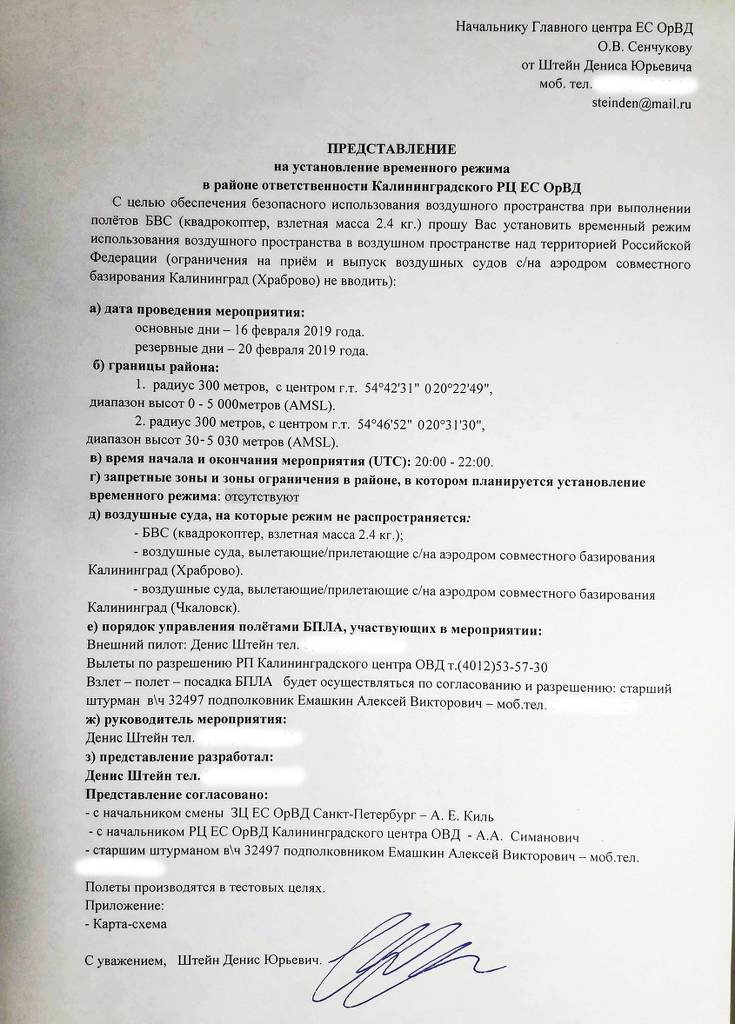
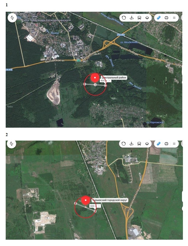
Clause 49 “Decree of the Government of the Russian Federation of 11.03.2010 N 138“ On approval of the Federal rules for the use of the airspace of the Russian Federation ”, which reads“ 49. Aerial work, parachute jumps, demonstration flights of aircraft, flights of unmanned aerial vehicles, ascents of tethered aerostats over populated areas, as well as landing (take-off) at the sites located within the boundaries of populated areas, information about which is not published in aeronautical information documents, are performed upon availability the airspace users of the permission of the relevant local authority, and in the cities of federal significance Moscow, St. Petersburg and Sevastopol - Allowing the relevant bodies of executive power of these cities. "In my case, the flight takes place at two points - to the west and north of the city of Kaliningrad, just beyond the Great Ring Road, outside the settlements, and therefore permission from the local government is not required. I decided on the geographical coordinates of each point: No. 1 - radius of 300 meters, with the center of the city. 54 ° 42'31 "N 020 ° 22'49", No. 2 - radius of 300 meters, with the center of r.t. 54 ° 46'52 "N 020 ° 31'30", the maximum flight height for each point is 5000 meters .
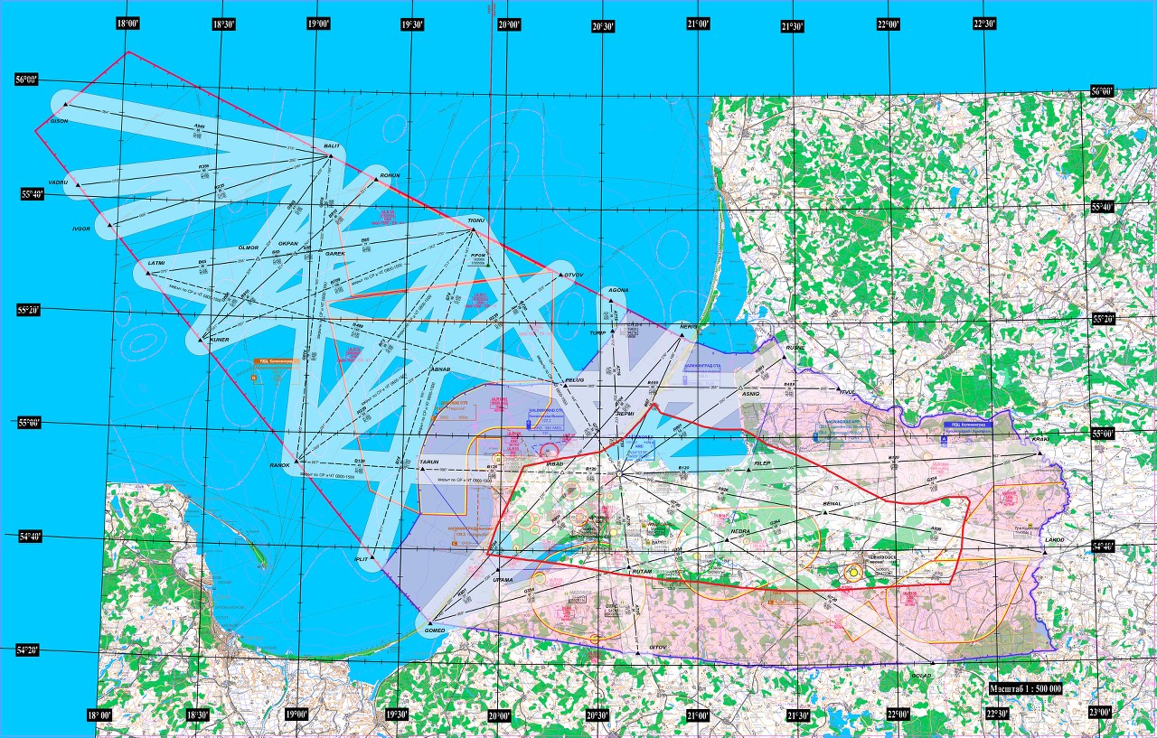
First of all, it is necessary to coordinate flights with the Kaliningrad Regional Center of the Unified Air Traffic Management System (Kaliningrad ECU ATM) with the planning manager for the TTI 8 (4012) 57-99-38, 8 (4012) 57-99-39. Attention! There are different District and Zonal Centers in different regions and in order to determine which RC and SEC of the EU ATM you are in, open the map showing the structure of the centers of the EU ATM.
During the conversation with the TTI planning manager I should inform about the intention to launch the UA, indicating the location of each point, radius, altitude and flight time.
In the process of negotiating, I was informed that in order to fly the UAV at specified points and in the range of a given height, I need to establish a temporary regime, as well as coordination of flights with the military airfield of Kaliningrad "Chkalovsk", since the points where I am going to launch my drone to the area of responsibility of this aerodrome (in this sense it is useful to have a special map where all these zones are indicated). But here I am forced to make a small digression and write a few words about the temporary and local regimes.
All the necessary information is in the Federal Rules for the Use of the Airspace of the Russian Federation. It says:
"If a need arises to use airspace at the same time, 2 or more users of airspace establish the prohibition or restriction of their activities in certain areas of the airspace of the Russian Federation in accordance with state priorities in the use of airspace, carried out by introducing temporary and local regimes, as well as short-term restrictions . "In paragraph 137 of the AFP RF RFI it is indicated:
The temporary regime is established by the main center of the Unified System to ensure the following activities:As for the local regime:
e) flight operations of unmanned aerial vehicles in the airspace of classes A and C.
Local mode is established by the Unified System's zonal center in the lower airspace to provide the following activities: d) flight operations by unmanned aircraft in airspace classes C and G.Paragraph 139 states:
“Local regime on airways and local air lines open for international flights, as well as in areas of airfields open for international flights, is not established.”Since my points of flight are located near the Kaliningrad Khrabrovo airfield, which is open for international flights, a temporary regime is set accordingly.
You do not need to know in advance what type of regime will be established - this will be reported to you in the EC ATM Center at the initial stage of the coordination of UA flights. However, since the submission deadline depends on this, it is advisable to understand this question as well.
Further, since I was told that it was necessary to coordinate my flights with the Kaliningrad “Chkalovsk” military airfield, I called the senior navigator of the military airfield and announced my intentions to fly at the specified points, indicating all the data I had communicated to the RC of the EU ATM. I was informed that, most likely, on the days and time I planned for aviation, flights will not be made and I can indicate these days in the documents submitted (submission). Since the security and defense capacity of the country are the highest priority, it is natural that flying UAs should not interfere with these tasks. Proceeding from this, it becomes clear that it is better to reserve additional days in case the flights cannot be carried out on the planned day, for example, due to the fact that military aircraft will be alerted.
Incidentally, if the combat alert is announced after the UAV has been lifted into the air, the owner of this drone will be obliged to land as soon as possible and notify the fact of this in the EU RC ATM. Naturally, the external pilot of this UA will be required to be constantly available for communication, for example, by mobile phone.
“When an illegal crossing of the state border of the Russian Federation, the use of weapons and military equipment of the Armed Forces of the Russian Federation on a violating aircraft, as well as when unidentified aircraft and other material objects appear in the airspace, in exceptional cases the air defense authorities signal“ Carpet ”, means demanding the immediate landing or withdrawal from the relevant area of all aircraft that are airborne, with the exception of aircraft that are engaged to deal with violating aircraft and performing search and rescue missions. ”So, the flights were tentatively coordinated with the Kaliningrad “Chkalovsk” military airfield and with the EU ATM Center (this in turn means coordination of flights with the Khrabrovo civil airport).
Now you need to make a submission on the establishment of a temporary regime (BP). When drafting this document, it should be borne in mind that the Submission for the establishment of a temporary regime is submitted to the Main Center of the Unified System (Moscow) at least 5 days before the required time for the introduction of the regime, and the Submission for the establishment of a local regime in the zonal center of the United System city (for the Kaliningrad region is St. Petersburg) at least 3 days before the required time for the introduction of the regime. The temporary regime shall be established by the Head of the Main Center of the Unified System, respectively, the document is addressed to the Head of the Main Center of the EU ATM, the local one is the Head of the EU ECC of the ATM and is addressed to him.
There is an Instruction on the development, establishment, introduction and removal of temporary and local regimes, as well as short-term restrictions (Order of the Ministry of Transport of Russia No. 171). This document determines the procedure and rules for submission of Views, as well as the amount of information that should be contained in it.
Here are the general requirements:
“Art. 6 The development of a temporary regime by the main center of the Unified System or local regime by the regional and regional centers of the Unified System begins with a submission from the airspace user that contains the following information:
a) the date of the event (no more than three main and three reserve days) and the type of activity;
b) when establishing temporary or local regimes for the event area:
- the boundaries of the area, indicated in the system of geographical coordinates (degrees, minutes, seconds), and the range of heights used (meters);
- start and end time of the event (coordinated universal time);
- the proposed flight levels for aircraft on the routes of air traffic services and in areas of civil airfields located within the boundaries of the area of the event;
- the proposed restrictions in the areas of civil airfields (if the activity on the use of airspace is carried out in the area of a civil airfield at altitudes from the surface of the earth (water) to an echelon of 3,050 m inclusively in radii from the aerodrome control point:
30 km - for the airfield during scheduled domestic flights,
50 km - for the airfield, open for international flights);
- reserve echelon for flight safety in special cases during the event;
c) when establishing temporary or local regimes for ensuring aircraft flights along the route (s):
- flight route (flight routes) of aircraft with a width established by clause 28 of the Federal Regulations, indicating route points in the geographical coordinates system (degrees, minutes, seconds) for each of its sections that are equivalent in length to sections with a flight time not exceeding 25 minutes;
- the required level (range of flight levels) for the flight route of the aircraft;
- lines of climb and descent on the flight route;
- the number and types of aircraft;
- the number of groups of aircraft, distances and intervals between groups of aircraft;
- distances and intervals between aircraft when performing group flights;
- time of flight (coordinated universal time) by an aircraft of each point of the route; when performing group flights, the time of flight of each point of the route by an aircraft that is the first from the group;
- sections of the flight route of aircraft with the state radar identification system equipment turned off;
- sections of the flight route of aircraft where it is planned to interfere with the means of radio engineering of flights and aviation telecommunications, the types of interference, the types of means of radio engineering of flights and aviation telecommunications, subject to interference;
- the time of entry and exit of aircraft in the airspace of a civilian airfield area at altitudes from the ground (water) to a flight level of 3050 m inclusively in radii from the airfield control point:
30 km - for the airfield during scheduled domestic flights,
50 km - for an airfield open to international flights;
d) permits to use the airspace of restricted areas and restricted areas received in accordance with Federal regulations;
e) data on aircraft and aerodromes (heliports, landing sites), from (on) which their take-off (landing) is allowed during the event;
e) the procedure for servicing the air traffic (flight control) of the aircraft participating in the event, indicating the geographical location of control points, frequencies of aeronautical radio communications and the procedure for establishing communications with them;
g) the last name, first name, patronymic, position of the head of the event and the method of communication with him;
h) the surname, initials, position of the person who developed the presentation on the establishment of the regime, and the method of communication with him.
The information specified in sub-clauses “b” and “c” of this clause of the Instruction must take into account the maximum deviations of material objects from the calculated trajectory of movement, taking into account the separation rules established by the Federal Rules. ”
In the text of the Submission we indicate what we have - the type of UA, its name (model, manufacturer), take-off weight.
Next, we indicate the days in which you plan to fly. In total, no more than three main and three reserve days can be specified (useful in case flights can fail due to circumstances beyond your control).
Then we indicate the boundaries of the flight areas: I always indicate the radii of flights, taking into account the maximum deviations from the calculated flight path, this is the best option for me, but the boundaries of the flight areas can be described not only by radii: for example, an autonomous flight of a UA over a long distance must include at least three points.
UAV flights can also be carried out along the route and in this case points of the route should be indicated in the system of geographical coordinates (degrees, minutes, seconds). In the case of a description of the flight zone in the form of a circle, the coordinates of the center of each point (degrees, minutes, seconds) are indicated.
The following should indicate the absolute altitude - the range of altitudes of flight UAV. Here we need to calculate the value of AMSL - Above Mean Sea Level - above mean sea level. To do this, you can use online elevation maps . We need to visually select the center of each flight point and record the value. So, I know that I will raise my drone up to a height of 5 km. In the more conventional AGL format - Above Ground Level - above the ground level, this value will be from 0 to 5000 meters.
In my case, the level of the earth’s surface is 30 meters above mean sea level and the record in AMSL format will be 30–5030 meters. If the ground level coincides with the average sea level, then the altitude range will be from 0 to 5000 meters.
Then we indicate the time of flights in the UTC standard - coordinated universal time. For the Kaliningrad region, you just need to take 2 hours from the local time in order to get the value of UTC . You can determine your time simply by typing “UTC time” in the browser search. During conversations with air traffic controllers in the EU, you will probably hear the word Greenwich more than once. The UTC standard replaces Greenwich (GMT) . In everyday life, when the fractional part of seconds is not important, Greenwich Mean Time (GMT) can be considered as the equivalent of UTC. Based on this, you can say, for example, “Twenty hours GMT” - you will be immediately understood.
If flights are conducted within the restricted areas or zones of flight restrictions, please indicate the permissions received in accordance with the Federal Rules for the Use of the Airspace of the Russian Federation. If flights are conducted outside such zones, as in my case, then we indicate this. Postal addresses, telephone numbers, radio frequencies of the aviation range of persons authorized to issue permits for the use of the airspace of restricted areas and restricted flight areas are published on the official website of the Federal Agency for Air Transport on the Internet.
Then we indicate the aircraft that are not covered by the regime: piloted by the UA, and also the aircraft departing / arriving from / to the joint-based aerodromes in whose zone of operation a temporary regime is introduced for the UA flight.
Further information is specified relating to the procedure for managing flights of UAs participating in the event: indicate the name of the external pilot of UAV and his mobile phone number for operational communication, the name of the event manager, the name of the person who developed the presentation, the purpose of the flights, contact numbers and name of officials with whose permission take off, flight, landing bvs.
Since the upcoming flights have already been verbally agreed with the Kaliningrad “Chkalovsk” military airfield, this should be indicated.
In the second part of the presentation, we indicate the flight map . These schemes display the radii, routes of the planned flights of UA, directly on Google, Yandex maps. For compiling such map diagrams, it is convenient to use Yandex.Maps or Google Earth. I usually open Yandex.Maps, I find the center point by the coordinates from the presentation on establishing BP, and with the help of the Ruler tool I build a straight line, in this case with a length of 600 meters, since the requested radius is 300 meters. Then, I save the screenshot and in Paint I draw a circle on the constructed line in such a way that the point of geographical coordinates is in the center of the drawn circle.The resulting graphic files are saved and inserted into the view file to establish a temporary mode.
After the submission has been made, we send it for initial approval to the ATM EC of the ATM via office@kld.sz.gkovd.ru . Then, after the submission was agreed, we indicate in the submission the name of the coordinator, in this case, the full name of the head of the EC ATM department of the Kaliningrad ATS center, print out the document and put a signature. Now, the presentation should be scanned or photographed. The resulting file should be e-mail - spbzc.rgm@sz.gkovd.rusend to the EU ATM Zone Center (in my case it is St. Petersburg) for approval. The graphic file should not be sent as an attachment - it is necessary to insert it into the body of the letter. (Requirement of security personnel of the ATM ATM from the point of view of security for opening investments from unknown sources). It is necessary in 20-30 minutes to call the ATM ETC - tel. +7(812)305-1778 and write down the name of the official who agreed on the presentation (in my case, the shift manager of the EU ATM Center St. Petersburg).
Further, it is necessary to enter in the section “presentation agreed” the name of the shift supervisor of the EU ATM center. After that, the document is printed out, we put the signature and again we photograph and send by e-mail - regimivp@matfmc.ruto the main center of the EU ATM. In this case, it is more expedient to insert the file as an attachment for subsequent printing by an employee of the ETC ATM. In 20-30 minutes we call +7(495)601-0664 and ask for confirmation of receipt. I do not recommend calling much later, as it may be difficult to find your presentation among others.
It must be remembered that the submission for the establishment of a temporary regime should arrive at the Main Center no later than 5 days, therefore, it is necessary to take into account in advance the time costs for coordination at the RC and ECC of the EU ATM.
Once you have received confirmation from the Main ATM ATM Center about receiving your submission, you can specify when you can call to get the temporary mode number. This number will be needed later in the preparation of the flight plan and it will become your unique identifier.
The temporary mode number is reported by the Main Center +7(495)601-0664 , and the local mode number is reported by the Zonal Center +7 (812)305-1778 .
So, I called the next day and I was informed of the temporary regime number that I recorded ( BP-508 ).
The next step is to make a flight plan.
A UA flight plan must be submitted to the EU ATM Center at least one day before the flight begins. It should be sent to the email address spbzc@sz.gkovd.ru in electronic form, so that it is possible to copy and paste the text using the computer's OS (the flight plan data is enclosed in round brackets and is intended for automated processing).
In the subject of the letter, you should indicate key data, such as I have - “ Flight plan of UAV on February 16, 2019 BP-508 Stein ”
The procedure for drawing up flight plans is described in the Order of the Ministry of Transport of the Russian Federation of January 24, 2013 N 13 “On approval of the Reporting Table the movement of aircraft in the Russian Federation . "
I planned to launch my drone at two points, respectively, my flight plan consists of two similar parts.
It can be noted that, unlike the old article, the flight plan should be drawn up using the letters of the Latin alphabet . These requirements were introduced just over a year ago.
(SHR-ZZZZZNow about how the flight plan is made: The
-ZZZZ2000
-M0000/M0500/ZONA R001 5442N 02022E/
-ZZZZ0100
-DOF/190216 DEP/5442N02022E DEST5442N02022E EET/UMKK0001 TYP/BLA
OPR/ RMK/ 300 5442N02022E, -508, 890XXXXXXXX)
(SHR-ZZZZZ
-ZZZZ2100
-M0003/M0503/ZONA R001 5446N 02031E/
-ZZZZ0100
-DOF/190216 DEP/5446N02031E DEST5446N02031E EET/UMKK0001 TYP/BLA
OPR/ RMK/ 300 5446N02031E, -508, 890XXXXXXXX)
sign of the beginning of each data field (except for the TYPE MESSAGE field) is the symbol "-" (hyphen).
The structure of the fields of the information part of the message about the plan to launch bvs:
Zone 3 - MESSAGE TYPE
field 7 - AIRCRAFT IDENTIFICATION
Field 13 - aerodrome and Departure time
field 15 - Route
field 16 - Destination aerodrome and total estimated elapsed time, replacement (NE) AIRFIELD (s) DESTINATION
field 18 - OTHER INFORMATION
In Field 3 (Message Type) indicates the type of message. The SHR index is used to report a UA startup plan.
An example of filling in field 3: (SHR
In field 7 (Identification index of the aircraft, mode and SSR code) indicates up to five digits designating the state registration number, if such registration is established by the aviation legislation of the Russian Federation. Since for BVS and other aircraft models with takeoff mass from 0.25 to 30 kg registration is not required, then the letters Z are indicated.
Example of filling in the field 7: -ZZZZ
In the field 13 (Departure aerodrome, time) the place where the balloon is launched (the attachment of a tethered balloon), the departure of a manned balloon or unmanned aircraft is indicated in one of the following ways:
- if it is located at an aerodrome, the four-letter designation of the departure aerodrome (departure departure platform) is indicated, and then without a space, the estimated take-off time in hours and minutes (four digits), with no more than eight alphanumeric familiarity being used;
- if the launch site (start) does not have a four-letter designation, then ZZZZ is indicated in field 13, and in field 18, after the abbreviation DEP /, the location indicated by geographical coordinates.
To designate the departure aerodrome, the ICAO four-letter index is used, as indicated in the “Location Indexes (Indices)” document (Doc 7910).
To designate the aerodrome of departure (departure landing site) of state and experimental aviation, the index specified in the Collection of four-letter pointers (indices) of the location of aerodromes, polygons, landing and helipads for use by state and experimental aviation is used.
In my case, the takeoff site of the UA is not at the aerodrome, which means ZZZZ is indicated, and the take-off time at the second point is at 21:00 (UTC).
Example of filling the field 13: -ZZZZ2100
In the field 15(Route) for manned aerostats and unmanned aerial vehicles, the value of the range of flight altitudes and the boundaries of the flight zone are indicated sequentially.
The value of the flight altitude range is written through a slash:
- in tens of meters at a pressure of 760 mm Hg. Art. - the letter S and without space four digits indicating the value of the train in tens of meters, and the required number of digits is supplemented with zeros (example: S0120 / S0540 ...);
- in tens of meters the maximum absolute height is the letter M and without a space there are four digits denoting the height in tens of meters defined by the minimum atmospheric pressure reduced to sea level, and the required number of digits is also padded with zeros on the left (example: 0020 / 0060 ... ).
The boundaries of the flight zone are recorded after the sign " / ZONA ":
- designation of breakpoints of the flight zone by geographic coordinates in degrees and minutes (up to 11 characters are used): four digits - latitude in degrees and minutes with the letter N (northern) or S (southern) and five digits - longitude of the seat in degrees and minutes indicating the letter E (Eastern) or W (Western), while the required number of digits is supplemented with zeros. Recording is done through spaces between the designation of each breakpoint of the zone (example: / ZONA 4955N 04312 4815N 04210 5012N 04410 /);
- "/ZONA" R — : — N () S () — () W (), (: /ZONA R020 4955N 04312/);
- , (:/ZONA ULR22/).
All information regarding the boundary of the flight zone is limited on both sides by slashes.
The maximum absolute elevation is indicated in tens of meters with a four-digit number in front of which the letter M is written, and the required number of digits is supplemented with zeros.
In my case, the absolute height value ( AMSL ) is indicated . In the second point, the height range is from 30 to 5030 meters (AMSL), respectively, the record takes the form: M0003 / M0503. Since I chose flight zones that are limited by circles, I need to specify the radius of the circle. There is an important point here: in my opinion, there is a flaw in this place of drawing up a flight plan.
The fact is that according to the requirements of the rules, only three familiarity with the indication in kilometers is indicated to indicate the flight radius of the UA. Based on these rules, the minimum radius of a circle will be 1 kilometer. The diameter of the circle will be equal to two kilometers. In my opinion, these are too big numbers and one should add another familiarity with the indication of hundreds of meters. The fact is that raising the UAV to an altitude of 5,000 meters, in most cases, it is enough for me to have a circle radius of 50 meters (the lift is strictly up). Even taking into account strong winds, a possible demolition of the apparatus, in most cases a radius of a circle equal to 300 meters is more than sufficient for safe flight. Considering the fact that some settlements are very close (especially in the Kaliningrad region), UAV flights in zones,the diameter of which is 2 kilometers can lead to the borders of settlements in these areas, and for flights over settlements already need permission from local governments. In my case, if the diameter of the circle were equal to two kilometers, it would go to the borders of two settlements at once - md. Alexander Kosmodemyansky and pos. Pregol. Based on the existing rules, I indicate the minimum possible radius of flight, equal to one kilometer and the central point of geographical coordinates.Alexander Kosmodemyansky and pos. Pregol. Based on the existing rules, I indicate the minimum possible radius of flight, equal to one kilometer and the central point of geographical coordinates.Alexander Kosmodemyansky and pos. Pregol. Based on the existing rules, I indicate the minimum possible radius of flight, equal to one kilometer and the central point of geographical coordinates.
Subsequently, when talking with the controller of the ATM ATM, I will separately point out that it is impossible to indicate a radius of 300 meters in the flight plan and make the appropriate entry in the comments to the flight plan. Ideally, one should strive to initially indicate the minimum radius of flight of a UA, equal to 1 kilometer or more, so that the text of the flight plan fully corresponds to the submission for establishing a temporary regime. The record takes the form - / ZONA R001 5446N 02031E /
Example of filling the field 15: -M0003 / M0503 / ZONA R001 5446N 02031E /
In the field 16(The airfield (ground) and total estimated elapsed time) for manned aerostats and unmanned aerial vehicles, the airfield (ground) where a landing is planned after the flight is completed, is indicated in the same manner as for field 13. However, if the landing site has no four-letter designation, field 13 indicates ZZZZ, and field 18 after the abbreviation DEST / indicates the location indicated by geographic coordinates.
The total estimated elapsed time until the end of the flight is indicated by four digits without a space, where the first two digits indicate hours, the second - minutes.
In my case, UAV landing is performed outside the aerodromes, therefore ZZZZ is indicated, the total estimated elapsed time is one hour.
Example of filling the field 16: -ZZZZ0100
In the field 18(Other information) indicates additional flight information, which is recorded after the corresponding letter characters separated by a slash.
DOF/ — (YYMMDD, YY — , — DD — ).
DEP/ — , 13 ZZZZ, ( 11 ): — N () S () — () W (), (: — 5402N04812E).
DEST/ — , 16 ZZZZ, DEP/ .
/ — () .
TYP/ — , , . :
BLA — ;
OPR/ — , (, , ), .
RMK/ — , .
EXAMPLE fill field 18 : -DOF / 190216 DEP / 5446N02031E DEST5446N02031E EET / UMKK0001 TYP / BLA
OPR / STEIN Denys RMK / ZONE CENTER RADIUS 300M 5446N02031E, BP-508, TO COMMUNICATION STATION 890XXXXXXXX)
Finished UA flight plan:
(SHR-ZZZZZSo, the flight plan of the UA should be sent to the ATM ATM at least one day prior to the event by e-mail - spbzc@sz.gkovd.ru . You should not send a flight plan to UAB much in advance - it will be difficult to find it later. After the flight plan has been sent, it is necessary to call back within an hour to the ECC of the ATM ATM +7 (812) 305-1778 and receive an acknowledgment of receipt.
-ZZZZ2000
-M0000/M0500/ZONA R001 5442N 02022E/
-ZZZZ0100
-DOF/190216 DEP/5442N02022E DEST5442N02022E EET/UMKK0001 TYP/BLA
OPR/ RMK/ 300 5442N02022E, -508, 890XXXXXXXX)
(SHR-ZZZZZ
-ZZZZ2100
-M0003/M0503/ZONA R001 5446N 02031E/
-ZZZZ0100
-DOF/190216 DEP/5446N02031E DEST5446N02031E EET/UMKK0001 TYP/BLA
OPR/ RMK/ 300 5446N02031E, -508, 890XXXXXXXX)
After the flight plan has been adopted, it remains to wait for the planned date of the flight for UA.
In accordance with the requirements of the current legislation, the airspace user reports to the main or zonal (regional) centers of the Unified System: at least two hours before the established start of the temporary or local regimes.
To commence activities related to the use of airspace, for which provision is established temporary or local mode, without receiving confirmation from the relevant operational bodies of the Unified System about their readiness to provide them is not allowed.
Since the UAV flight zone is located in the area of responsibility of the Kaliningrad “Chkalovsk” military airfield, I call the senior navigator in no less than two hours and announce my intention to fly according to the data specified in the temporary regime submission.
After that, I call in the ECC of the ATM Department, the EC RC of the ATM and report the period of my actual activity. In at least one hour, you should call the ATM ATM Center and request permission to use the airspace.
It is necessary to take into account that messages about the beginning and ending of the use of airspace are transmitted by the airspace user to Kaliningrad EC EC ATM (TIR Planning), in whose area of responsibility temporary or local regime is established no later than:
Immediately before takeoff of the UA, I call to Kaliningrad EC of the EU ATM and report the start of work. Since the flights in the second zone begin in an hour, I simultaneously request permission for the TTI and this point.
- five minutes after the planned start of the activity: on the actual time of the start of the activity; about delay, transfer or cancellation of the activity;
- ten minutes after the end of the activity: the end of the activity; about breaks in airfield flights for more than an hour;
- immediately after the expiry of the estimated time of landing of the aircraft or when it does not arrive at the destination aerodrome, if there is no information on the location of this aircraft.
As I coordinate flights with the Kaliningrad “Chkalovsk” military airfield, I inform the senior navigator about the start of the UAV flights. After the flights in the first zone have been completed, I report the completion of flights in this zone to the Kaliningrad district center of the EU ATM (TIR planning) and to the senior navigator of the airfield of Kaliningrad “Chkalovsk”.
After that, I move to the second flight location. It is necessary to constantly monitor the time, as the existing rules very strictly oblige to report no later than five minutes after the planned start of activity about the delay, transfer, cancellation and the actual time of commencement of activities. At the second point, I also immediately before takeoff, call to the Kaliningrad center of the EU ATM and the senior navigator of the Kaliningrad “Chkalovsk” airfield and announce the start of work.
After completing the flights in the second zone, I call Kaliningrad EC of the ATM and the senior navigator of the Kaliningrad “Chkalovsk” airfield, informing you of the end of the activity. Since I indicated the second, reserve day of flights, I should not immediately call the Main Center of the EU ATM and remove the temporary regime.
Having completed the flights on the second day following the example above and completing the flights, in addition to reporting the termination of activities to the Kaliningrad RC of the EU ATM and the senior navigator of the Kaliningrad “Chkalovsk” aerodrome, I need to remove the temporary regime, since I have already flown all the days specified in to establish a temporary regime. To do this, you should call the Main Center of the EU ATM +7 (495)601-0664 and report the actual completion of the activity.
№ 171 “ , , , ” 31: , — . , .Now I will briefly describe the procedure for obtaining a permit for TTI:
The procedure for obtaining a permit for TTI is a temporary regime:
1. You need to obtain permission to fly UA from a local authority (if flights are made within the boundaries of settlements).
2. Coordination of UAS flights with a military airfield (in the event that flights are made in the area of responsibility of a military aerodrome)
3. Primary coordination of UAS flights with the EC RC ATM, receiving information about the conditions of the UAS flights (in my case Kaliningrad - 8 (4012) 57-99-38, 8 (4012) 57-99-39)
4.Preparing a submission for establishing a temporary regime, sending and coordinating it with the head of the EC ATM Center (in my case Kaliningrad - office@kld.sz.gkovd.ru)
5. Sending and coordinating the submission for establishing a VR in the EU ATM Center (in my case Saint St. Petersburg - spbzc.rgm@sz.gkovd.ru +7(812)305-1778).
6. Sending and coordinating the submission for the establishment of BP in the ATM ATM Center (Moscow - regimivp@matfmc.ru +7(495)601-0664).
7. Getting the number of a temporary mode (MCC ATM Moscow +7 (495) 601-0664).
8. Sending the flight plan of the UAV to the ECC of the ATM ATM at least one day before the start of the event (in my case St. Petersburg - spbzc@sz.gkovd.ru +7 (812)305-1778).
9.Not less than 2 hours before the event, report the period of your activity to the official of the military aerodrome, with whom the flights were previously agreed upon (in the event that flights are made in the area of responsibility of the military aerodrome).
10. Not less than 2 hours before the event, inform the period of your activity (confirm that you will use the regime established for you or remove it if you change your mind) in the EU ETS of the ATM +7 (812) 305-1778 or HZ of the EU ATM +7 (495) 601-0664 and the EU ATM Center (in my case Kaliningrad 8 (4012) 57-99-38, 8 (4012) 57-99-39).
11. Not less than 1 hour before the event, request permission to use the airspace from the EC ATM Center (in my case Kaliningrad 8 (4012) 57-99-38, 8 (4012) 57-99-39).
12.Report no later than five minutes after the scheduled start of the activity: the actual time of the start of the activity; on the delay, transfer or cancellation of activities in the ATM EC of the ATM (Kaliningrad 8 (4012) 57-99-38, 8 (4012) 57-99-39).
13. Report on the actual time of commencement of activities to the official of the military aerodrome, with whom flights were previously agreed upon (in the event that flights are made in the area of responsibility of the military aerodrome).
14. Report no later than ten minutes after the end of the activity: on the actual termination of the activity; about breaks in airfield flights for more than an hour at the EC RC for ATM (Kaliningrad 8 (4012) 57-99-38, 8 (4012) 57-99-39).
15.Report the actual time of the end of the activity to the official of the military aerodrome with whom the flights were previously agreed upon (in the event that flights are made in the area of responsibility of the military aerodrome).
16. Report on the actual time of termination of activities in the City Center for ATM Moscow +7 (495) 601-0664 and remove the temporary mode (in the event that flights are not made by UA).
The procedure for obtaining a permit for TTI - local mode:
1. You must have permission to fly UA from the local government (if flights are made within the boundaries of settlements).
2. Coordination of flights of UAV with a military airfield (in the event that flights are made in the area of responsibility of the military airfield).
3Primary coordination of flights of the UA with the EC of the ATM, obtaining information about the conditions of the flights of the UA (in my case Kaliningrad 8 (4012) 57-99-38, 8 (4012) 57-99-39).
4. Drawing up a submission for establishing the local regime, sending and coordinating it with the head of the EC RC for ATM (in my case Kaliningrad office@kld.sz.gkovd.ru).
5. Sending and approving the submission for the establishment of an IR in an ATM ATM (in my case, St. Petersburg spbzc.rgm@sz.gkovd.ru +7 (812)305-1778).
6. Getting the number of local mode in the ECC of the ATM (in my case, St. Petersburg +7 (812)305-1778).
7. Sending the flight plan of the UAV to the ECC of the ATM ATM at least one day before the start of the event (in my case St. Petersburg spbzc@sz.gkovd.ru +7 (812)305-1778).
8. At least 2 hours prior to the event, report the period of your activity to the official of the military aerodrome, with whom flights were previously agreed upon (in the event that flights are made in the area of responsibility of the military aerodrome).
9. No less than 2 hours before the event, inform the period of your activity (confirm that you will use the regime established for you or withdraw it if you change your mind) Aircraft ESS ATM (in my case St. Petersburg +7 (812) 305-1778) and the EU ATM Center (in my case Kaliningrad 8 (4012) 57-99-38, 8 (4012) 57-99-39).
10. Not less than 1 hour before the event, request permission to use the airspace from the EC ATM Center (in my case Kaliningrad 8 (4012) 57-99-38, 8 (4012) 57-99-39).
eleven.Report no later than five minutes after the scheduled start of the activity: the actual time of the start of the activity; on the delay, transfer or cancellation of activities in the ATM EC of the ATM (Kaliningrad 8 (4012) 57-99-38, 8 (4012) 57-99-39).
12. Report the actual time of commencement of activities to the official of the military aerodrome, with whom flights were previously agreed upon (in the event that flights are made in the area of responsibility of the military aerodrome).
13. Report no later than ten minutes after the end of the activity: on the actual termination of the activity; about breaks in airfield flights for more than an hour at the EC RC for ATM (Kaliningrad 8 (4012) 57-99-38, 8 (4012) 57-99-39).
14.Report the actual time of the end of the activity to the official of the military aerodrome with whom the flights were previously agreed upon (in the event that flights are made in the area of responsibility of the military aerodrome).
15. Report on the actual time of termination of activities in the ECC of the ATM ATM +7 (812) 305-1778 and remove the local mode (in the event that UAs are not flying).
If the dispatcher of the ATM EC ATM when reporting information about flight conditions, the UA has announced that the flights will be subject to the establishment of a local regime, this somewhat simplifies the task, since there is no need to coordinate the document and coordinate flights with the main ATM ATM center.
Photo \ video filming from the air
In this topic, in addition to flying UA, there is an important aspect that requires consideration - shooting from the air. In the Russian Federation, only hundreds of UAV flights, drones, radio-controlled civilian model aircraft, most of which are equipped with a camera for photo and video shooting, are made every day.
Shooting from the air refers to aerial work. Even if the ultimate goal of aerial photography is to obtain artistic images, this does not exclude the possibility of obtaining geospatial information classified in accordance with the Decree of the President of the Russian Federation of November 30, 1995 No. 1203 to state secrets. In accordance with Article 27 of the Law of the Russian Federation "On State Secrets", access to work related to the use of information constituting state secrets is carried out by obtaining a license to work with information of a corresponding degree of secrecy.
In accordance with current legislation, to conduct such surveys requires:
- Permission to shoot the General Staff of the Armed Forces of the Russian Federation;
- , ;
- ;
Upon completion of the shooting, the filmed material is transferred to the regional FSB for declassification for subsequent use in the public domain.
I sent requests to the General Staff of the RF Armed Forces and the FSB Directorate to obtain permits for aerial surveys in order to obtain artistic photographs and video recordings (sunsets, sunrises, historical objects, wildlife photography, animals from the air) and I was informed that permission for such surveys requires a license to carry out work related to the use of information constituting state secrets. In this case, a significant problem arises, since, based on the existing rules, such a license is required for each owner of a quadrocopter, a radio-controlled aircraft, a flying wing, a glider, a helicopter, including toys from the Children's World, etc. that even the so-called “pocket” drones of a small size have already installed a camera for photo and video.
Given the huge number of owners of radio-controlled aircraft models in the Russian Federation, as well as the existing difficulty in complying with and obtaining a license to carry out work related to the use of information constituting a state secret, it is even theoretically impossible to provide the required conditions.
In my opinion, the situation that has developed over many decades requires permission, since at present the ordinary citizen cannot perform aerial work in accordance with the requirements of the law, due to the fact that the necessary conditions were not created for this, but at the same time any A citizen has the opportunity to receive permission to use the airspace in the Russian Federation for UAV, drone, radio controlled aircraft models.
Since the legal status of shooting from drones is not covered at all in the media, and the legislation does not clarify this issue, then in carrying out aerial shooting each owner of UAV, a radio-controlled model aircraft actually has to be guided only by the arguments of his own mind, which in my opinion is unacceptable.
The widespread introduction of drone, BVS in our lives in recent years has only aggravated the problem. The number of flights made has increased many times, and the main performers of such flights have become people who do not have the knowledge, skills and practical experience in aircraft modeling and aircraft design. Only 8-10 years ago, multi-rotor UAVs of vertical take-off, drones were only available to people with knowledge and experience in areas such as electronics and mechanics. Factory, serial products, which are now abundantly filled with many online stores were still missing. The need for knowledge in various fields of science, aerodynamics, electronics to build their own aircraft naturally cut off that numerous part of the people for whom these days drones have become just a kind of gadget. The attitude to drones as gadgets, toys has received its natural development - the number of flight accidents due to the fault of the human factor has increased many times. Fortunately, and only by chance, in most cases it still does not affect the interests of third parties.
Based on the fact that every owner of a UAV, radio-controlled model aircraft makes an independent decision on the expediency of shooting a particular object due to the absence of any specific shooting rules that take into account the current situation with drones in the country, this decision can sometimes be erroneous, wrongful from the point of view of the law .
To avoid such problems, it is enough to be guided by similar principles:
1. Shooting and flying UAs should not be carried out in restricted areas and restricted areas, without the appropriate permits. You can see similar zones on the web site fpln.ru or using Google Earth by installing the corresponding KMZ file.
2. You should categorically exclude surveys, flights in the vicinity or above objects:
- any structures of the Ministry of Defense of the Russian Federation (buildings, military units, polygons, etc.)
- cities with military infrastructure, military harbors, ships, any military defense objects
- defense factories and other industries, or other enterprises with a special visit regime
- active military and civilian airfields
- UFSB structures
- - places of imprisonment, correctional colonies.
3. Flights, shooting within the border strip should be carried out in coordination with the border service of the Federal Security Service of the Russian Federation. The border strip is a strip 25 kilometers wide, established along the entire border of the Russian Federation (with the exception of the Arctic Ocean). This is especially important for the Kaliningrad region - the small size of the region in conjunction with the border strip, 25 kilometers wide, in most cases requires coordination of flights with the FSB frontier service. On the map below, it is depicted in red from the state border (blue color of the line) deep into the region.
It would be erroneous to believe that the launch of even a small UAV in a deaf place may go unnoticed: UAV vertical takeoff is a source of increased acoustic noise and there are often witnesses of the takeoff and landing, and all structures have special attitude to UAV for obvious reasons. Even if you do not carry out aerial work (ordinary citizens and cannot carry them out in the full sense of the meaning of the word) and you have permission for the TTI, in any case you need to coordinate flights with the border service of the FSB of the Russian Federation in order to avoid subsequent serious problems. For each fact of an unauthorized launch of a drone, UAV, a radio-controlled model aircraft in the border zone, an investigation is being conducted.
As for the transportation of the drone, UAV - if you do not have coordination with the FSB border guard service, the best option would be to refuse to take the drone with you in private or public transport. If it is discovered by the FSB and special services at the border service, there will be a lot of questions for you, as cases of using drones for illegal purposes have become more frequent. All this is especially true for the Kaliningrad region.
Since many owners of drones publish pictures from the air immediately after the flights, it is necessary to remember that these are not just pictures, but operational information that can be used for various purposes. The publication of such operational data should not give rise to their use by hackers and should not prejudice the country's defense.
Concluding the article, I would like to note that the existing procedure for obtaining permits for military airspace for civilian UA is in itself quite complicated, especially for novice users of the airspace of the Russian Federation. Only after receiving repeated practical experience in obtaining such permits, it can be noted that it will be implemented in practice.
The purpose of the article is precisely this - to explain and show the civilian population of the Russian Federation exactly how the procedure for obtaining permits to use the space in the Russian Federation is carried out and all sorts of nuances in this regard are described.
Time costs, a large number of approvals discourages a significant number of owners of UAV, radio-controlled models from performing flights in accordance with the Federal Rules of Air Traffic Management. Today, in the Russian Federation, more than 90% of all civil aviation UAV flights are carried out illegally.
Two years ago, I sent my appeal to the head of the Federal Air Transport Agency (Rosaviatsia) describing the situation and the need to simplify the procedure for obtaining permits for the TI. I received a response stating that the changes I proposed would be taken into account when amending current legislation.
Currently, there is a draft of the Federal TIES Rules with amendments aimed at simplifying the use of airspace for Russian citizens. We are talking about UA flights without obtaining permission for TTI at a safe altitude range. If a law is adopted, this will be a big step forward in simplifying the procedure for all owners of radio-controlled model aircraft, as this automatically legitimizes all small radio-controlled model aircraft and drones that, due to their design features, are not able to make long flights and rise to a height of over 100 meters.
However, even if changes to the Federal Regulations are approved, the described procedure for obtaining permits for TTIs when flying to a higher altitude is likely to remain valid for a long time and therefore be relevant to all users of the airspace of the Russian Federation.
Link to download files.
Full article in pdf format.
Article author: Denis Stein
vk.com/steinden
steinden@mail.ru
Source: https://habr.com/ru/post/441408/
All Articles