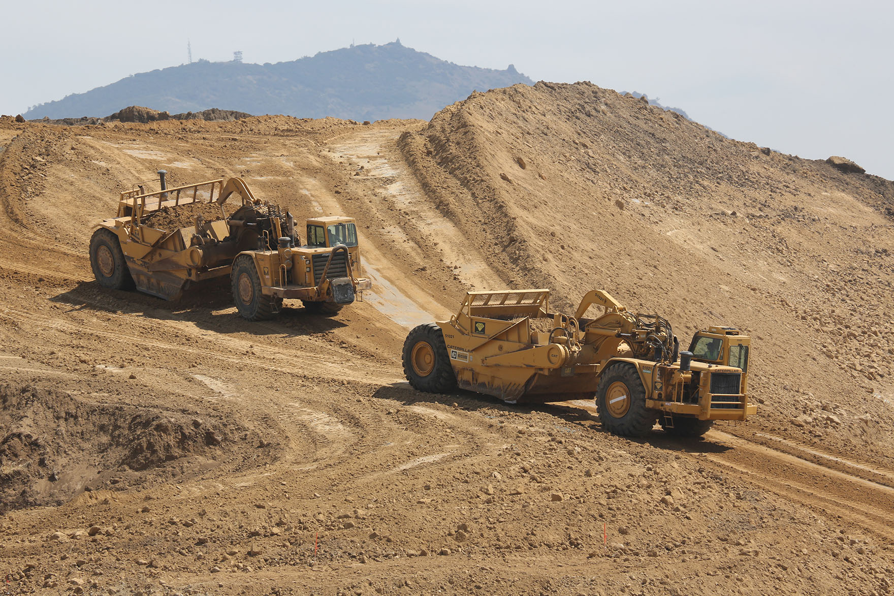
"We are changing the relief of the earth" - IT goes to a large construction site
What could be more absurd than getting lost on the way to an interview with a cartographic startup? But about my discomfiture, I nagged enough in the last article - in this there will be only important things.
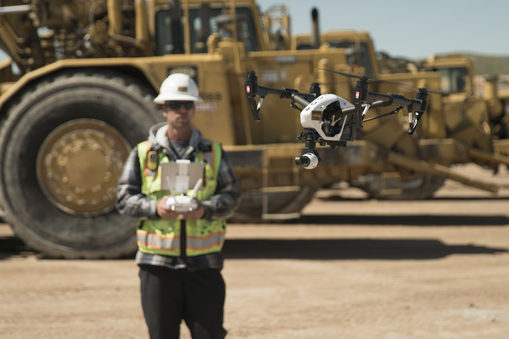
I recall last week I started writing about drones at a construction site and talked with Dmitry Korolev, one of the four founders of TraceAir, a service that tries to change the construction industry with the help of drones, photogrammetry and analytical algorithms. Like his other interlocutors, I mistakenly thought that drones were in the center of the startup design. But it turned out something completely different.
')
How did you get started?
I started coding class in the fifth. At school, an informatics teacher showed a BASIC, and I’m like this: aaaaa, you can code the game! Then he moved to gymnasium school 1567, in physical education. There was just an awesome party. Cool things related to electronics. We soldered amplifiers, IR receivers / transmitters, we ourselves wrote a protocol to them, a client. Now one dude from our class in the Valley, another girl a few classes later, we were also there, but came back here.
Our physicist was a clever peasant (taking advantage of the opportunity - Alexander Andreevich, hello), wrote us tests on pascal, gave the grid on a computer, and we solved them. Once we decided, “let's hack the test of a physicist so that he highlights the correct answers for us”. In general, we had a very cool school.
And what did you already know-know how for the last grade of school?
Basic, Pascal, knew how to solder all sorts of devices, a little assembler. At some point, I tried to look at Delphi, but I wouldn’t have looked better - Delphi is something else ... When the network went - C / C ++, Perl and PHP.
Wrote PoC-exploits. At about the same time, in the 11th or at the end of the 10th grade, it was possible to write to the Hacker magazine by mail, and it was published. I wrote there: "dudes, let's work on IT-sec together, who wants." A crowd gathered, but did not last long, about two years. We did some pretty interesting things. If the focus on security, you can even find something in the annals of the list.
Next was the Physical Department. A friend told me, programming there is cooler than in the VMC. This man severely broke me off - there was no cool programming there. As soon as I realized this, I began to look for all sorts of security projects. But he quickly realized that he had to go to a more legal plane.
In the second year I used fizfakovskimi clusters, and the teacher told me: “Dim, if you launch some kind of exploit from the physics department, you can do it at least through a proxy”. I say, "Alexey Valentinovich, forgive me, please, I will not do it again." And from that moment began to move on the development. It was 2003–2004. This teacher was looking for orders, and we coded. Engines for scientific conferences, social maps, some kind of geographic social network.
Tell me what the product does?How to combine the love of the sky with IT
Between the university and the beginning of TraceAir, Dmitry had several startups, and we discussed them in more detail in the last article . He is a professional paraglider, so he was always looking for how to combine the sky and IT.
There was a service for aviation. According to the trackers, viewers from the ground could track the race and understand what was happening in the sky at that moment. The service achieved some success, but did not bring money - this was not interesting for investors.
There was a service for analyzing space images. He allowed, for example, to mark forest fires on the map.
During the boom of drones, Dmitry and the team wanted to launch air delivery in Moscow, but limited themselves to coffee in Gorky Park. They faced all the problems that drones carry with them, but the money ran out before solutions were found.
After a trip to Silicon Valley in 2014, the future direction became clear - we need not the drones themselves, but serious industrial services for them. This started the TraceAir.
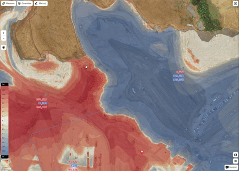
Drone or airplane flies in zigzags over the ground, takes a bunch of photos. Then these photos by photogrammetry algorithms on GPU servers turn into point clouds and a 3D model. Our software compares this 3D map with all the documentation that is loaded there. It analyzes, compares, and suggests how earthwork logistics should be built, how to replace soils — when you replace bad land with good, you predict the behavior of the earth — compression / swelling, which also greatly affects the work order.
Shooting terrain with drone
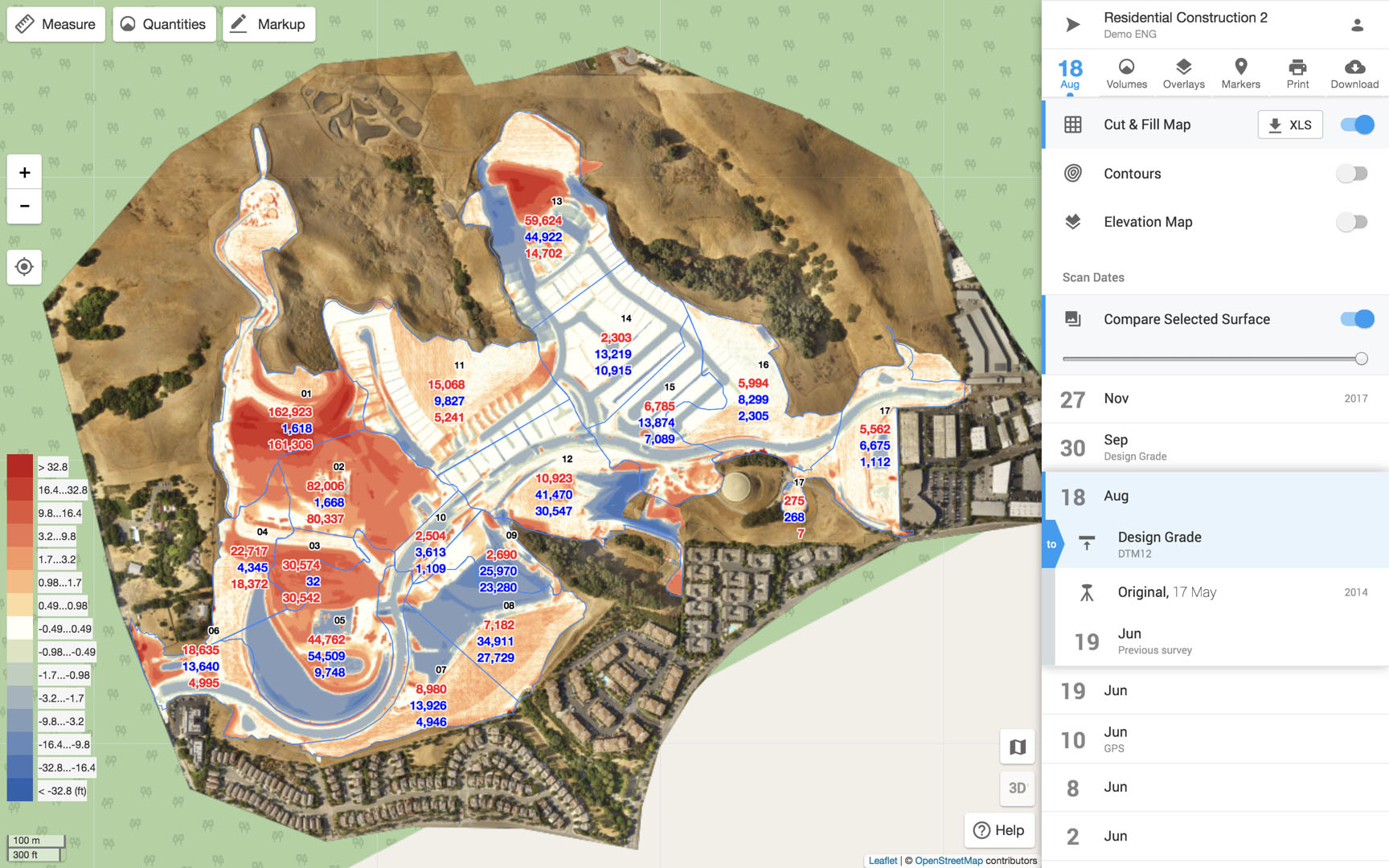
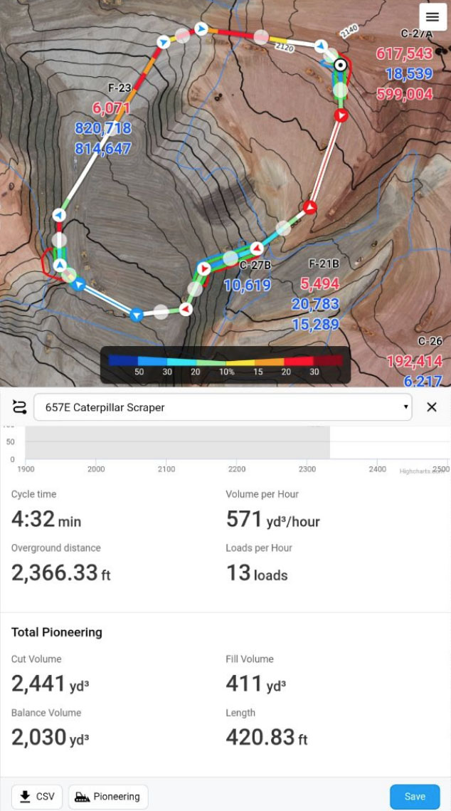
It looks like the work with the construction site in the application
He says, for example, “here you are already in the project, please do not break it, do not go there. Here you still need to dig down - this land will swell so much. Here you have to lay, because you will have more land here than you calculated. And here you have pipes and they are set 5 meters away from the project. ”

Builders look and understand, “OK, here we have to dig so much - this is conditional for a week of work”.
Key technology in comparing what you have with what you should have. The technology compares, and then either gives hints or helps the construction participants to interact. Communication works more on the Russian market. Tips for what to do - in American.
So this is a replacement for geodesy?
This is the very first thought that usually comes. In fact, surveying does not solve anything. Other companies that make drones for construction are trying to replace geodesies. The drone flew, scanned everything, made a 3D model, and this is where the surveyors work ends.
To compare and make decisions, we need engineers, not surveyors. A foreman who was digging the ground used to turn to engineers. They already hired surveyors. Surveyors removed the landscape, gave the data to the engineers. And those are: “oh, we have a break. Now we drink coffee, and there is already the end of the day. In a week we will answer you. ” After a week, the foreman finally answers the question, and only after that does he decide to dig.
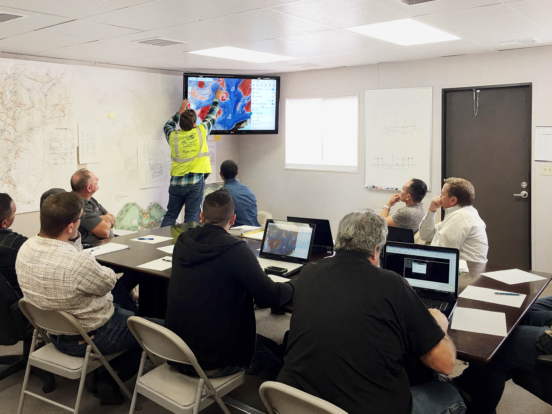
With us, it looks like this: the foreman opens a mobile phone, leads around a plot of interest, “here I have so much land, it is distributed like this. Here is the best way for my technique to bring it here. It will take so long. ” All information here.
That is, this is a reduction in the distance between the builders and the expertise that engineers have in their heads. We look at what people are doing in the fields, throwing in new features under their use cases. So, if we replace someone, then engineers. Surveyors remain on the scan, and we are already deciding how to use something and build better.
If there is a union of engineers who says, no drones at construction sites?
Engineers are already bumping into us in America. Previously, they considered everything long and expensive, and we came to this - here are all the calculations.
Engineers tell us, "guys, this seems to be a licensed activity." And we say, "Go on dick, we have software." Well, something serious begins. California engineers are driving us a little barrel. Of course, not all, some understand that progress cannot be stopped.
When I was 15, I worked as a surveyor. Just ran with a stick and put it where they say. But I did not understand a damn how it works further. Did you have to figure it out?
Of course. The contractors are just a bunch of dudes with sticks who just run and put points. We tried to understand why they are not as advanced as surveyors should be.
There are few advanced in Russia and in America. There are dudes who customize processes and they are smart. They know how all these satellite receivers work, why they need several frequencies, how the atmosphere is affected there, what the PPK mode is and what the RTK mode is. We also have to figure out how this works.
The entrance ticket to our industry is accuracy. No accurate data - exit ticket. And do not care how tricky analytics algorithms you have, which suggest how best to dig, if you give inaccurate data. All tips will go down the drain.
This is a problem that drone startups face. They give generally left data. We sank of this in Russia. At the very beginning, we were constantly kicked: “yes, what drones to replace geodesy! They are inaccurate. ” We spent a lot of time on confirmation and comparison with the geodetic data, we figured out how the accuracy, the average deviations work. When you understand deeply, you begin to understand where surveyors mow. If you send two of them one after another, they will have different models. He placed one wand on a stone, another missed a mound.
Does the drone decide this?
Yes. A model is a cloud of points. When you shoot with a stick, there will be as many points as you put the stick. And the drone creates tens of millions of points - the same amount as a lidar survey, only costs much less. And there is no need to sew later lidar clouds, because the lidars are removed from several points. Drone really simplifies surveying. Now a bunch of companies say that the simplest geodesy is geodesy with drones.

Photogrammetric model of the landscape
Pro business in America
When we flew to Silicon Valley, we were told: “if you can earn a ruble in Russia, then you can earn ten here. Better show what you can do in Russia. Why fly here right away? We agreed, but the step was a mistake. Those who start doing business in Russia, and then moving to America - they survive, not because they have a business in Russia, but despite this.
Experience in Russia does not affect the experience in America.
People make decisions differently. For example, at a construction site in Russia, at the very beginning we were perceived as an anti-fraud system. With it, the contractor will not overstate the estimate and make a left registry. When we arrived in America, we tried to sell evenly. And they say, we have no problems with that.
Markets work differently. In Russia, we worked with developers who were themselves general contractors. All shot down into one big construction company. And in America, a lot of small firms unite around some conditional project and interact with each other. We went to general contractors, but it turned out that general contractors are just a layer, and you can’t decide anything with them.
There are other problems. For example, the export of land from the construction site. In Russia, it was possible for 100 rubles to throw the remaining land from the project into any ravine. And also from the next ravine to pick up. Only now are starting to tighten the screws, and prices are rising. In America, if you have a handful of earth left - this is a problem. To dispose of it is very expensive. So when we say “you will have land in balance. You don’t need to bring anything, take anything away, ”for them it’s a super value.
Where do you have more customers?
In the 16th year, when we went to America, we tried to sell in the same way as in Russia. But from April to November of the 16th year we didn’t manage to sell anything in America either, until a dude from Stanford joined us.
He asked us:
- Are you sure that someone needs this here?
- Of course you need, - we say, - in Russia, they buy well.
- And here you talked with how many builders to understand what kind of pain they have?
- With zero.
Then we began to explore the market, found a bunch of people from the industry, about 120 people. We came and asked, “dudes, tell me what your pain at the construction site is and just listened without selling anything. Just trying to understand the industry. In the end, we said, “so we made the technology (technology does not equal product). Do you think it is useful or useless? ”Someone said that it could be useful for someone. Someone said no need at all and no sense.
And someone - "you need to wrap it right now!"
And so we went to residential construction. There, people work without a general contractor. The customers themselves reproduce, over and over again, areas with houses, and manage contractors. We agreed with them, and everything began to develop. Russian history was nothing to do with it. At the end of 2016, we realized that we were torn between the two markets and then we abandoned all sales in Russia altogether, returned only now at the end of 2018.
It turns out now basically everything in America?
More sites, less revenue. Here we worked at large industrial facilities - all sorts of construction plants, gas processing, oil refining. And in America it is residential construction, when you prepare the land on which houses are then built.

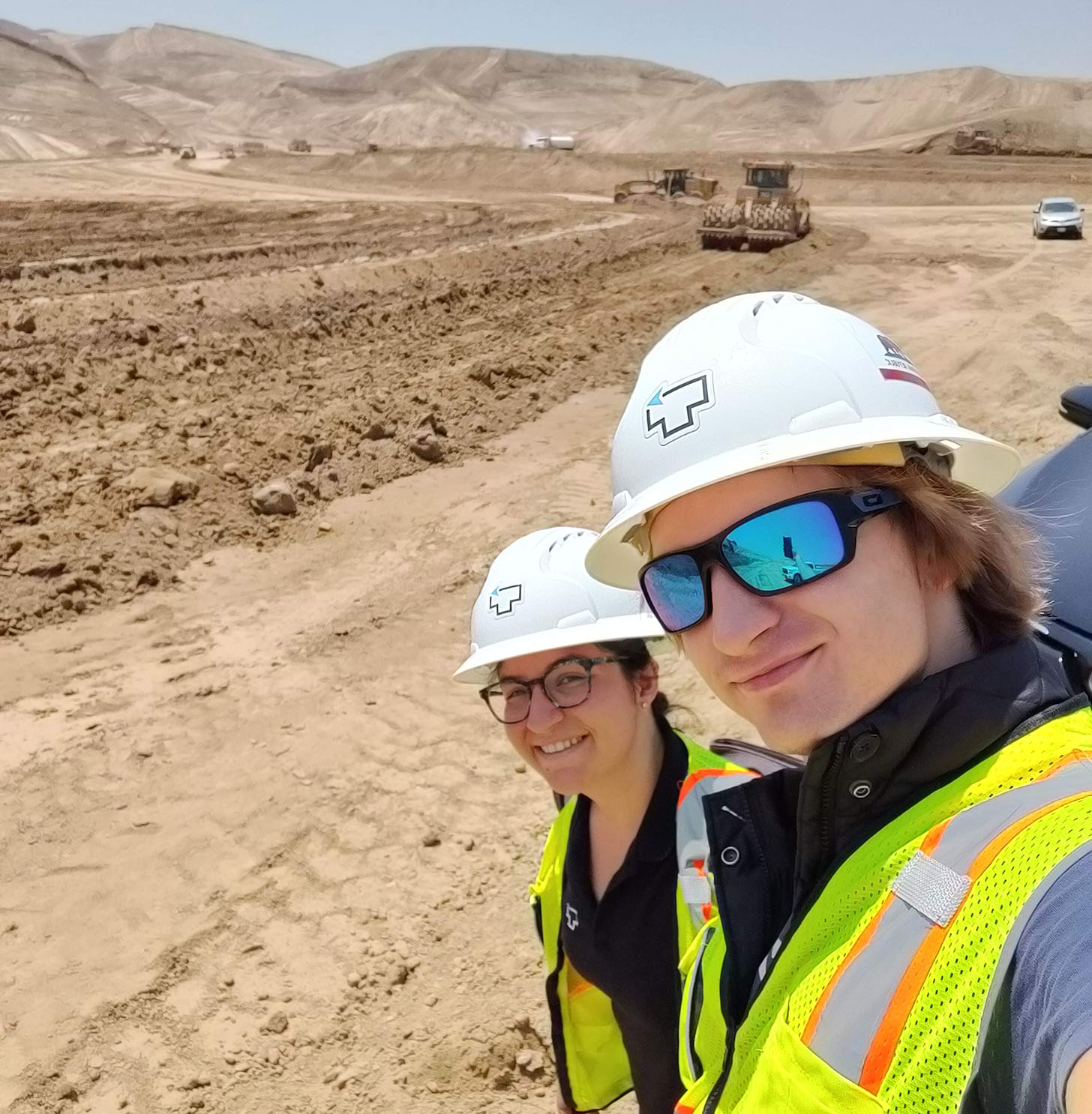
Residential development in California
When you build a huge factory, it's billions of dollars. A small building in 5-10 acres - only tens of millions. But even in America we are trying to focus on large areal objects of 400–500 hectares. When you tear down hills, build pads and put a bunch of little houses on them. One-story America.
How photogrammetry works
If you take a mug, take it off from different angles and then quickly flip through all the pictures - your brain will understand that the mug is three-dimensional. He will see all its angles at the same time and complete the three-dimensional image by himself. So is photogrammetry. The drone flies from above and removes everything from different angles. Then collects from these photos model.
Photogrammetry in any case gives an error if you remove the pad once. We shoot once a week, and sometimes even more often. It turns out the timeline on which a bunch of copies of the construction site shows how it historically developed. At this historical slice, we can improve photogrammetry, pull up the data under each other, in a cunning way without distorting it. Although minor deviations builders are ready to understand. Those surveyors will tilt the stick a little, and it turns out garbage.
If everything is done correctly, it will be more accurate than from a surveyor with a stick, who, himself, decides where to put, where not to put.
Previously, photogrammetry worked like this. The drone flew, took photographs, the pilot loaded them onto a computer, processed it and handed it to the customer on a flash drive. There are 108 gigs. The customer asks how to open them, and to him - “as you wish, so open. Download something.
We all do it on the back and display it online on a mobile phone. We cut all these files, we do tiling, we translate into the coordinate system of the construction site - and they work there not in degrees / minutes, but in their system. And you need to go into it without losing accuracy.
This is a task with a bunch of parameters. How many marks do you have on the ground to go to the coordinate system of the line, at what height the drone flies. We selected all these amounts of parameters to get the accuracy that builders need. In America, the standard is 1/10 foot. If we fall into this standard - everything is fine, if not - goodbye.
What's inside the product
Tell us straight through the modules - what does it all consist of?
Previously, we collected our drones and set up a custom camera. DJI has not done normal drones yet, so we collected everything from scratch. They took GoPro, put a certain lens, because only one lens gives accurate data, and the rest give shit. This continued until the end of 2016, when the DJI finally started to do normally.
In general, testing drones is also not just looking for features on the site. Suppose there is a new model, conditionally Phantom 4 Pro. We send it to our test site, where a lot of control points are captured with a total station. We scan it with this drone and see what will happen in 20-30 flights. If 80% of the points were filmed without deviating from the permissible rate, then you can work. If not, most likely something is wrong with the camera.
Of course, the most important thing is the camera. The drones themselves are now able, using any third-party software, to automatically fly in zigzags. And before that it was quite difficult, and we used any raw opensource, which allowed us to automate the flight. But the flight programs are far from the key technology. Anyone can make them.
We also do not do photogrammetric software ourselves - its dofig. We tried a bunch of different, and stopped at PhotoScan - it is good in terms of accuracy.
Drones, cameras, photogrammetric software - you all take on the side. What do you write yourself?
All that farther. Working with drawings, comparing models, calculating volumes, comparing with existing drawings, converting models from 2D to 3D. In order to benefit the builders, you need to go through a whole chain of actions. At least 54 independent steps with different technologies - from how the drone flew, before the builder saw his volumes.
All data - photos, documentation - get into our so-called Back Office site. Then everything is processed on Amazon GPU servers, the required number of instances rises.
What are you writing all this on?
The entire front end part is node.js and React. Map on Leafleat. The backend is all that works with Amazon — usually Java, but lately everything is being translated to Amazon Lambda, and there it’s easier for someone to write on. Where fast calculations are needed - there is C ++. And everything else is Python. Node.JS now, too, slowly on lambda replace.
We use the Amazon stack a lot, all of their micro services are very cool.
Separate greetings to Roskomnadzor. When this trash happened, we then suffered a lot. I wanted to come and all ... with fire and sword!
Not judged?
I wrote to the lawyers: let's fill the case? But they said, and their tasks enough. It would rather be for fun. I really want to, but still enough of his propulsion.
Instances photogrammetry is spinning, processing CAD files. And everything is very sensitive to changing parameters. Even if somewhere you change conditionally from 100 to 90, the accuracy dramatically increases. Everything is in the details, so I can not talk about them.
We ourselves think over the tips to the builders.For example, we analyze the site and say:
- This is where your road is worse for this scraper, this is better. And here you have a scraper does not go on such a slope. Circle the mound on the left.

- Prepare the ground with a CAT D6 or D8 dispenser. He will do it in half an hour. With such a slope will stop, and with this will not stop.
Characteristics of the same bulldozers also take somewhere?
Yes.We wrote them off with Caterpillar Handbook 47. With what bias they drive, on what gear, at what speed. Moreover, when we wrote forecasts about how best to build roads, we took not only with Caterpillar, but thrust GPS trackers into real scrippers and watched how they traveled in order to adjust the real characteristics to our model. As they drive in denser ground, as in loosened soil, everything is taken into account.
All these geological things your developers need to know?
Everyone should - yes, not everyone knows. Products know for sure.
Geologists who are engaged in prediction, for example, where the earth will swell, do not have the ability to code, align, build a model of behavior. And when our products come to them for data, they ask for some model, the geologists answer: “we will collect this month, now we cannot”. We are such: “to hell with you, just tell us how you do it”. They say, and it really sounds that you can simply code.
Then the products all fully figure out and transmit the data to the development.

And then what should be able to developers?
Developers need to understand the product, why we do it at all. We have a horizontal structure, there are no certain chiefs, no "I am a fool you are a boss." The programmer must understand that everything is for the specific user cases, for the sake of a specific user - here he is, with dirty hands he pokes at the iPad.
We show a lot of team photos and video from the field. How builders work on their dusty sites. When the UX-er sees how a small laptop with a dusty touchpad uses its interface, it’s like this: “what would I do ****!”
On a conventional iPad, everything is convenient, and a couple of extra clicks are not terrible. And then he understands - it is necessary to replace all the fuck and greatly simplify. The more you sync a person with a real user, the better.

How is the company
How many people are there now?
42
Enough?
Not.Just six more developers have hired. We have an office in the Valley, an office here and a little bit of people distributed throughout Russia.
There are a lot of cool programmers here, it's easier to assemble them. When we started, Masha, our head of product, had a software company. A part of her programmers flowed to us when Masha joined us. Some developers worked on my previous startup. There was a dude from Belgorod, now he moved to Moscow to communicate more with the team, there is a dude from Minsk. Kohl (of our devops) we found randomly, just on freelance.ru. One dude from Kiev QA. People come here regularly. In America, we carry people to grocery synchronization, we ourselves come here once a quarter. There are pluses of remote development, there are minuses.
What are the cons?
The downside is that you spend more time syncing. If dudes start to be far from the product, then we try to get them back. We remind that we do it for the sake of our builders, and not just to make a cool feature.
So I left America now, I start to leave the information field and I am already making efforts to stay abreast of affairs in the states - this is difficult. But of course, the pros pay for themselves. To assemble a team in America is nonsense.
When hiring you have to sift people through some special specifics?
Algorithmics should be. We all run through conditional problems, for example, about the inequality of the triangle. Here the object gives you something similar to a triangle. How do you check - is it a triangle or not?
If the dudes guess the inequality of the triangle and can write it, then okay - the basic pieces understand. There was still a joke about the address. If dudes can't find us on the map, then they are unlikely to have a place in a geodesic geographic startup.
Understood, I would not have passed.
Actually, I'm joking, we never did that.
The main thing is that a person should be ready to change his paradigm from “I’m just a developer, my task is to code from here to dinner” before understanding “why the heck do you code it, how does it connect to your real user”. Developers are accustomed to knowing nothing at all. What the project manager said to them is what they are doing.
And we have no project managers.
There is a skill that you will not test, and we are trying to implant it. You can not put up with shit. We have written in the company's values, if you see that something is going wrong, then raising a red flag is not an option - it is an obligation.
If the layout has gone or is loaded for a long time - no need to get used to it. Correct, if you can, and if you can not - find the one who corrects.
Why IT to go to construction
You started with romantic things - hacking, paragliding, love of the sky. Are you bored with building now?
Construction is the most fucking and romantic thing that can only be. I felt this straight when, in 2015, I went to our first sites of Morton to dive into the construction industry. It seemed to me that the builders are such incomprehensible people who are herachat there.
And then we came to the site, where there is something like a construction stand, a weekly discussion on how to proceed. It's frosty outside. Men stand in sheepskin coats, smoke. One looks at a handful of land, at an unfinished building, at a crane. And in his eyes you can see some kind of inner smile. And here he says to the neighboring same brutal peasant: "We, the builders, change the relief of the earth." In the second, something romantic also wakes up at once, and he is such a “yes ...”
Then I understood that the construction is something really cool for people. Where flights, where IT - and here is the real world.
It has come. But at first it was not. Did you choose a construction site because there was money in it?
When we were told, “earn at least something in Russia,” and we returned to Moscow, there was nothing to do in it. There are no agricultural fields, a career somewhere in Siberia. Around one building. That is, it came randomly, and when they began to dig, they realized how beautiful it is.
We then discussed what moves us at all, why we work so much, we promote our business. We want to make an automatic building. Clicked on the map, and look at the progress bar. And TraceAir will manage the equipment so that everything builds itself.
This is the vision of the company we want to achieve in 20 years. When we are told, “would you like to try drones in a farm or somewhere else?”, We say - no, we are not talking about drones - we are talking about a construction site. We want to automate it, and still cut very dofiga. This is the eight-trillionth industry, but it is generally untouched by IT. A lot of things got stuck in the eighties, somewhere even in the seventies or sixties.
The Hadron Collider was built for 16 years, and it could have been much faster on an automatic construction site. Even an ordinary house - and then the problems, errors and delays dofiga.
We want to give an opportunity to humanity (because I love humanity) with the help of automation software to turn plans from imagination into reality in the most optimal, most efficient and fast way. Here is a superposition. This is what drives us all, and we figure non-stop.

But sometimes it seems from the outside that building - especially in Russia - is the business of dark people. There's a lot of money, corruption, factories are worth billions. Does it bother you?
We simply do not work with such people. In the beginning, we were used as an anti-fraud system. For Morton, at four sites we saved 30 million rubles in four months simply because contractors were trying to inflate the estimate, to attribute something.
It is written in our values - do not deceive and do not put up with those who are deceiving. If we are asked to raise the model, "to give the contractor more money," we will send the fuck up. And, by the way, this was once.
- And lift so that it looked as if we had done more.
- Dude, what are you - fucked up?
In America, there are no stupid additions, but there builders may not specifically tell developers that they will have to do double work. And the developer will pay twice. And we tell them, “it is not necessary to transport land twice. There is a short way. ”
We are actually loved by both contractors and developers, although it seems that by bringing transparency, we are making the contractor bad, because he just wants to do nothing and earn more. Our software optimizes the entire OS, and we allow the contractor to do everything faster, thereby reducing its internal expenses. It turns out all good.
I heard about the idea of throwing robots to Mars, so that they would automatically build a colony there. Want this?
Of course you do. Well, when that happens, I'm sure TraceAir will be there.
Instead of conclusions
We have a regular heading - called "10 questions to the programmer." We talk there with regular developers, and in the end they ask their question to the next participant. I picked some for you.
Come on.
From studying what technology you most kayfanul?
TCP / IP. How networks are connected and how they work.
If you are given the opportunity to fly to Mars without a return ticket, will you fly?
No, I will not fly to one end. Only if I take with me technologies that allow me to build something and come back.
If what you do becomes illegal - will you continue or will you leave?
Omitting the fact that it was already ... if the same stupid laws as in Russia, then, of course, I will continue the pancake. If you are a startup and no one has judged you - most likely you are not doing any revolution in your area. Without violating established laws, you will not change anything. So the answer is obvious - yes, of course I will continue.
I also need a question now?
Well, if there is.
There is something where, in your opinion, people are mistaken en masse, and only you see how right?
Source: https://habr.com/ru/post/426465/
All Articles