Coding rabbits are looking for treasure
Part one. Google earth in fog
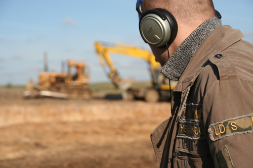
The weather favored this weekend, so the Rabbitone Coding Team consisting of rabbitone and a restorer , armed with a metal detector, decided to go to the area for a swag. We didn’t want to go far, so we started searching for nearby anomalies.
Under the cut text and a half megabyte images.
')
The field across the street from the office is quite suitable for searches, if not for the tall grass and the builders who decided to fence off half of the field with a fence. Let's look at the map.
The newest paper map available is 2003.

In Google Earth, almost the entire city is in a fog, but you can consider individual roads. We will use it to bind scanned maps. We are interested in maps of scales 1: 50,000, 1: 25,000, and so on. trekhverstevki (3 versts in inch).

Map of 1982 - several buildings and a water tower are shown. Later we found out from the locals that in Soviet times there was a farm on the field.

The Polish map of the Military Geographical Institute - they were issued between 1919 and 1939. The map shows a detached yard.

Military topographic map of the provinces of 1856-61, three-stepping. The letter F - Folvarok (manor). I don’t have a full list, but I found a fragment on the Wanderer’s website.

Overlay cards on top of each other using tags in Google Earth. Binding is carried out by eye on landmarks that do not change position (churches, cemeteries, geographical reference points).

After the imposition of the estate is over the farm - either because of inaccuracies of the map and the imposition, or it was in fact.
I give the idea for a startup: a map service with an archive of maps and a time frame for moving to old maps. Earn by downloading maps and points of attachment to GPS. Eeeh, a dream!
Part two. In field.
For the search we need:
- Metal detector (no need to call it a mine detector - it detects not only mines, but not the device, but the head is looking for :) - Fisher F-4, a good model of last year.
- Shovel - without it in any way.
- A bottle of water - laundered items from dirt.

Going into the field, we saw that it was all overgrown with half-rotted rapeseed, which we did not have time to remove. Next to the construction site, the workers of the grader moved a few centimeters of land - just as much as is necessary to remove the rape and leave future finds.


The device operates in two modes - dynamic and static (pin-pointer). In the dynamic mode, it is necessary to move the coil relative to the metal, in the pin-point mode (as an inspection metal detector) - you can simply bring the coil to the metal, but the discriminator does not work (ferrous and non-ferrous metals do not differ).
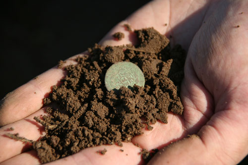
The first signal. The figure shows the relative electrical conductivity of the metal. This conductivity corresponds to a copper object the size of a coin (arrow on the scale above). The depth (depth) is clear - 2..4 inches, which means that the item found is really colored - rust and iron oxides give a similar, but depth-spread signal.

Digging?
Read the sequel on Friday.
- Examine the area
- First finds
- Clean and evaluate
- A bit of history
Transferred to a hobby .
Source: https://habr.com/ru/post/42490/
All Articles