Japan will prepare 3D maps of all highways
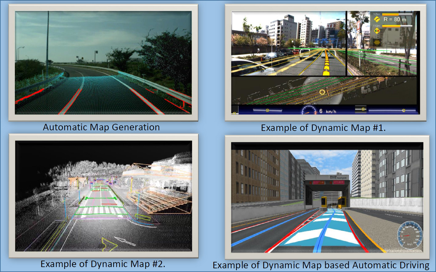
Autopilot movement on a 3D road map. Slide from Mitsubishi Electric Presentation
The host country always prepares for the Olympic Games with the utmost care. Some are building new stadiums, hotels, and building tunnels worth billions of dollars. But Japan decided to invest resources in the creation of 3D-maps . After mapping to the 2020 Olympic Games, all 30,000 km of highways in the country will become fully suitable for unmanned vehicles .
Probably, thanks to the Olympic Games, Japan will become the first country in the world where all highways will open for robokars.
The project took over the joint venture, which included the cartographic company Zenrin and a subsidiary of Dynamic Map Planning , founded on June 13, 2016, as well as the nine largest automakers in Japan : Toyota, Nissan, Honda, Mazda, Mitsubishi Motors, Suzuki, Fuji Heavy Industries, Isuzu and hino.
')
In general, this is a real national project. In contrast to the Olympic megastomes in other countries, it is carried out with the participation of commercial companies and partly at their expense.
Digitization of key highways will be organized with the help of cars equipped with special equipment (in the photo below). The parent organization of the joint venture will provide automakers with computers with the necessary software for processing the collected data.
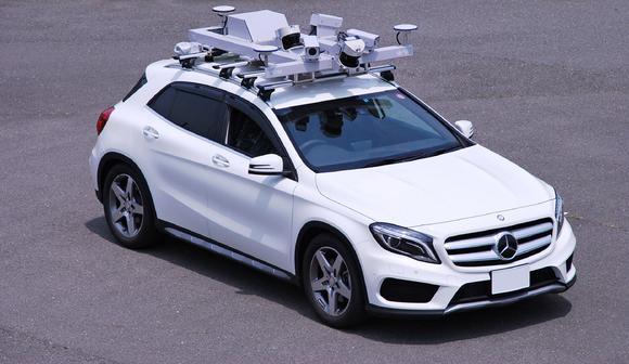
Car equipped for 3D laser scanning of roads. Photo: Mitsubishi Electric
Digitization of 300 km of main highways will be only the first step in drawing up a 3D car atlas in Japan. Such an atlas is part of the interdepartmental Program for the Strategic Promotion of Innovations, which was adopted by the Cabinet of Ministers of Japan and instructed the Joint Venture Dynamic Map Planning to be executed.
In the process of 3D laser scanning, clouds of terrain points are created with spatial coordinates XYZ and intensity of the reflected signal. The resolution of ground-based laser scanners, which characterizes the density of reflections and the accuracy of their fixation, is several millimeters. Scan data can be presented in the form of a three-dimensional model, a drawing, a set of sections, which allows you to get the most complete digital picture.
3D laser scanning provides high-precision and fast mapping of roads and objects of transport infrastructure with coordinate reference.
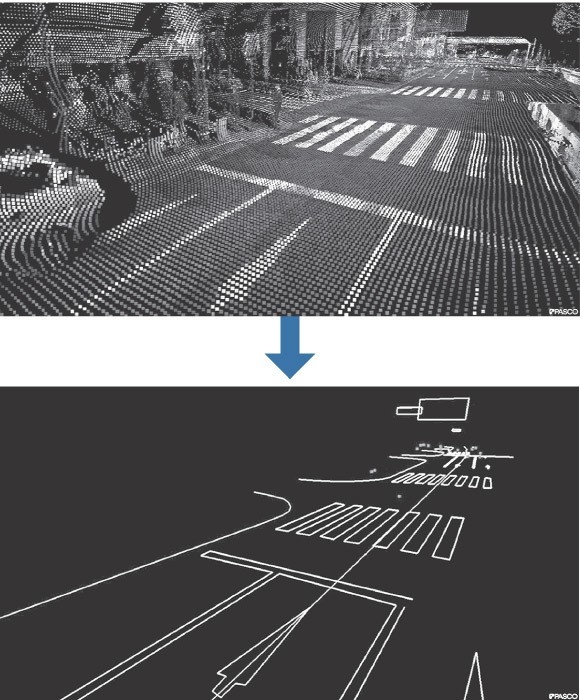
3D laser scanning of the road. Photo: Mitsubishi Electric
The presence of a 3D-card is the most important condition for the ubiquitous unmanned vehicles. Sooner or later such cards will have to be created in all countries of the world. This is understood in Russia: “After 20 years, autonomous cars will force out traditional cars, as they drove out horses in their time,” said Alexander Bykov, head of the traffic police department at the All-Russian forum for road safety.
In Russia, they are going to prepare in the near future for the movement of unmanned trucks the first route , but in Russia the 3D-digitization project of all roads will probably take several decades. Due to the concentration of efforts in a short time, Japan intends to carry out the task in three years. It is easier for them to do this, because the area of Japan is much smaller than the area of Russia, and the total length of the road network is about 10% less than in Russia.
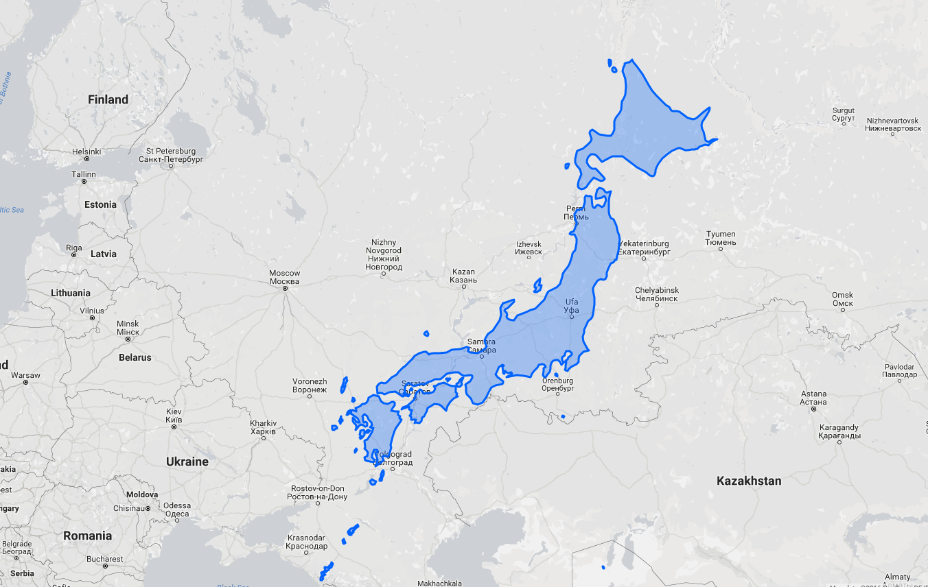
Comparison of the area of Japan and Russia. Illustration: thetruesize.com
The 3D road map includes an accurate 3D model of the road, as well as the coordinates of all objects, including road signs, marking lanes, obstacles, traffic lights, pedestrian crossings, traffic police, noise bands, fences, etc. Ideally, the navigator with a 3D map should always have up-to-date traffic information and operational changes to the maps, as the Yandex.Probork service is trying to do so that the unmanned vehicle chooses the optimal detour route, if necessary.
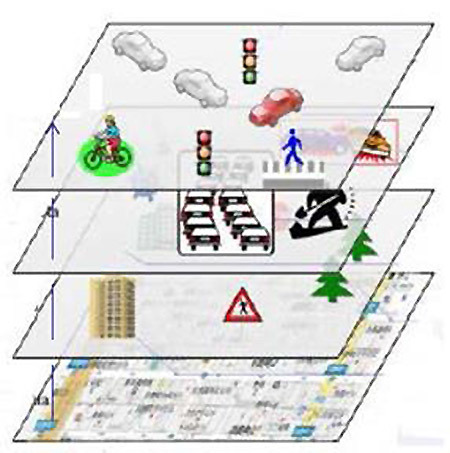
Information layers with different update rates on a dynamic roadmap. From top to bottom: update every second; every minute; hourly; statics. Slide from Mitsubishi Electric Presentation
For mass distribution of unmanned vehicles, it is required not only to create accurate 3D maps of roads, but also to improve the software of cars so that the autopilot program does not try to drive between the wheels of the trailer, like Tesla autopilot . It is also necessary to improve automobile navigators so that when positioning, not only GPS coordinates, but also speed and direction data are taken into account. Thus, the autopilot can better navigate in the tunnels, in the city or on roads in dense forest, where the GPS signal is weak or absent.
3D laser scanning equipment in Japan was developed by Mitsubishi Electric. The Japanese national project, with government support, can be carried out at a faster pace than the current leaders are capable of in 3D digitizing roads. Now it is Google, the German company Here and the Dutch TomTom.
After a quick 3D digitization of 30,000 km of expressways, work will begin on digitizing the rest of the road network, which in Japan has a total length of about 1.27 million km. The total cost of such a project, according to preliminary estimates, will be several hundred million dollars. The organizers intend to carefully work on cost reduction and optimal resource planning.
Source: https://habr.com/ru/post/397219/
All Articles