Big Transfer, or Forward to Cenozoic
80 million years ago, at the turn of the Mesozoic and Cenozoic, the Earth was with one of its most favorable states - the latitudes of Siberia and Alaska were in the subtropical zone, the Arctic islands and Antarctica were covered with forests. All that is needed to return to this state is to restore the Cenozoic water exchange of the polar basin with the equatorial seas.
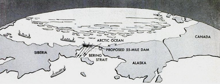
To implement his plan, the author (engineer Peter Borisov) in the 1960s proposed to build a dam across the Bering Strait.
47% of the USSR was occupied by permafrost, 75% periodically experienced temperatures of -40 degrees. It was not easy to get there, it was difficult to live there, it was difficult to build, it was expensive to operate equipment and buildings. Experience has shown that output in the northern regions is several times more expensive than in a temperate climate, and only the concentration of natural resources mined there pays off.
Permafrost map:

It was and became
The cold Quaternary period in which we live and which lasts 2.5 million years old was preceded by an epoch that took about 62 million years and was much warmer. At that glorious time in the north of Yakutia there were poplars and redwoods, chestnut and vine grew in Greenland, and palm trees rustled in the Volga region. The temperature of surface waters in the Arctic was +14 degrees, and at the equator was not much higher than the current one. Accordingly, there was no permanent ice cover in the northern seas.
')
However, the idyll was over - the rise of land began to prevail over its descent, the continents grew, the former intensive water exchange between the equatorial and polar waters was broken. The reduced influx of heat into the Arctic forced the heat-loving vegetation to the south to go. The restoration of the ice cover on the future Arctic Ocean has begun. Ice is better than water reflected solar radiation, and the process of glaciation went on increasing.
Theory
Comparing the duration of the current cold and warm periods preceding it, Borisov suggested that the mild climate is typical for the Earth, and the current cold is only a temporary misunderstanding. The author considered ocean currents to be the determining factor: it’s not just that grapes are grown in France at almost the same latitude, and tundra vegetation reigns in Newfoundland.
Therefore, it is enough just to restore the circulation of water from the equatorial regions to the polar regions, and the mechanism will turn in the opposite direction:
• the more ice will melt, the more heat will absorb the surface of the Arctic basin;
• as a result, the air humidity will increase, its infrared permeability will decrease, which will also serve the purpose of warming
Given:
In the Arctic Ocean - three "crane" through which water flows. The tap with warm water is the largest - from the Atlantic with the North Atlantic Current (298 thousand cubic km / year). The crane is smaller, cooler - from the Pacific through the Bering Strait (36 thousand cubic km / year). The third crane is the freshwater runoff of the rivers of Siberia and Alaska (4 thousand cubic km / year) *. Atlantic waters are prevalent here. At the end of their journey in the Chukchi Sea, they encounter a "dead end" - the Bering Strait - through which the Pacific waters meet them. Accordingly, along the way, the Atlantic waters turn around disappointedly and wander home. The path of water from Svalbard to the Chukchi Sea takes 5 years.
* - the author so, modern figures are different
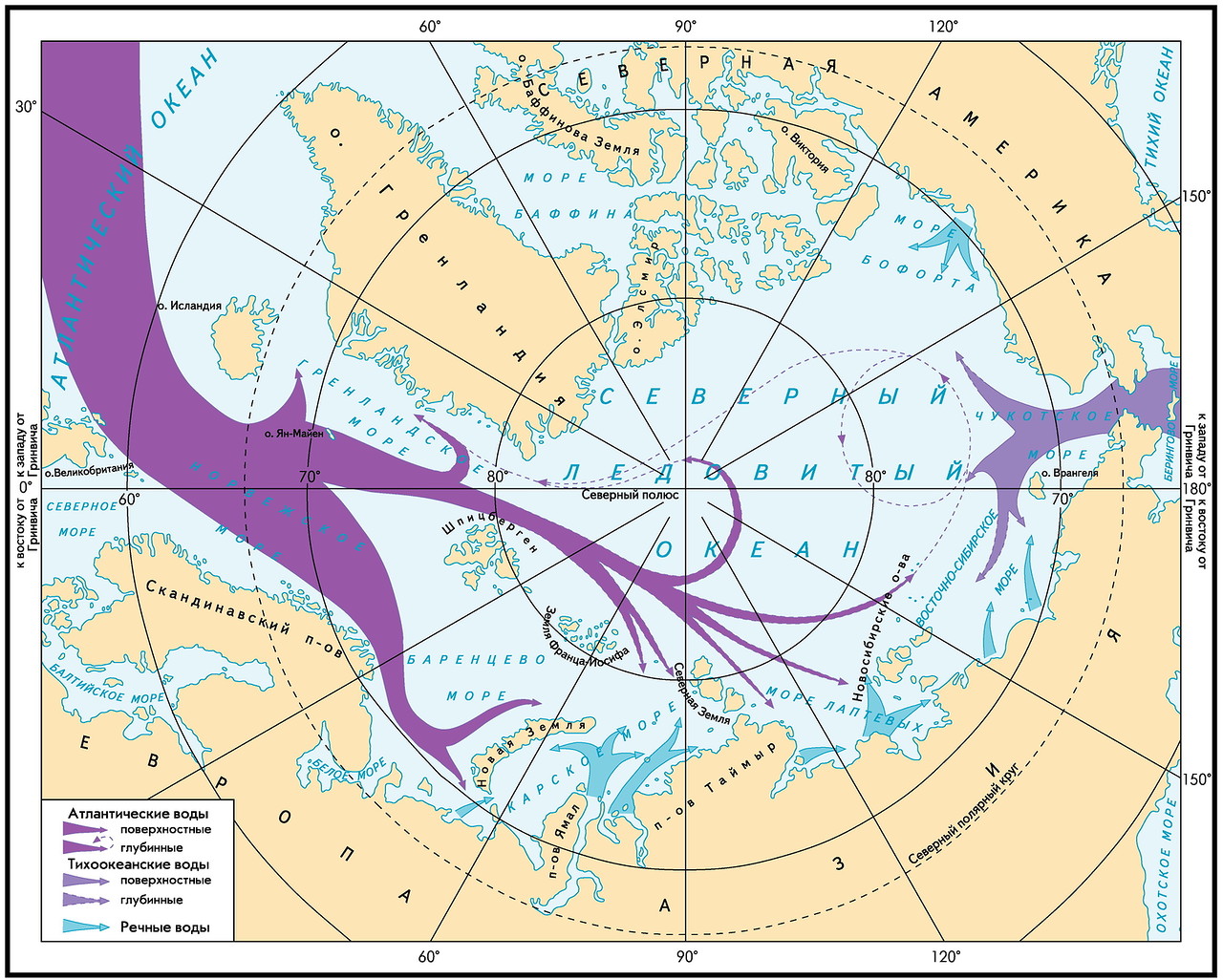
Drain occurs in the same Atlantic already colder waters (338 thousand cubic km / year). The main runoff is through the Faro-Shetland Canal (163 thousand cubic km / year). Moving towards warm waters that have not yet reached the Arctic, this stream unfolds a considerable part of them back.
Task:
1) to stop the flow of relatively cold and not too salty waters from the Pacific into the Arctic;
2) reduce the discharge of cold water towards the warm Atlantic;
3) to organize a through channel of warm and saline Atlantic waters through the Arctic Ocean;
4) to ensure the removal of the top layer of desalinated water from the Arctic Ocean (fresh water freezes faster and, because it is on top, does not let warm water to the ice).
Answer:
(338-163) -36 = 139
we round it up to 140 thousand cubic km / year - that is how much water needs to be pumped from the Arctic to the Pacific through the Bering Strait.
To do this, you need to build a dam in the strait, which will not only block the current from the Pacific Ocean to the Arctic, but also provide pumping units with the help of pumping units in the opposite direction.
To understand the scale - to take 140 thousand cubic kilometers of water is equivalent to reducing the level of the Arctic Ocean by 10 m annually.
If a
If this is accomplished, then, according to the author, the time for the movement of Atlantic waters from Spitsbergen to the Bering Strait will be halved compared with the current situation and will be 2.5 years. A direct consequence of this will be an increased influx of heat into the Arctic. Gradually, the Arctic Ocean will free itself of ice, temperatures will increase in the northern part of Eurasia, droughts will decrease, the flow of Siberian rivers will increase **.
** - note for residents of the Far East: according to calculations, the cooling of the Pacific Ocean will be temporary and will not exceed two years
The operation was proposed to be carried out in several stages, observing the changes and choosing the most appropriate parameters. The first climate changes were expected in just a few years.
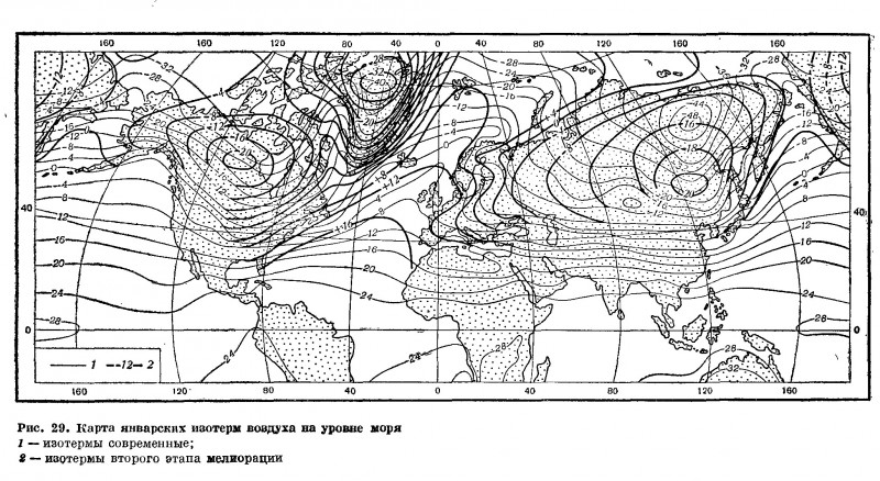
Map of air isotherms before and after reclamation (clickable):
Those interested can familiarize themselves with the details in the book of P.M. Borisova "Can a person change the climate" - it is online.
Technics and economics
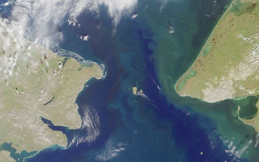
The width of the Bering Strait in the narrowest part is 74 km, the maximum depth is 59 m:

In connection with the remoteness of the construction area, it was proposed to build a dam from large reinforced concrete blocks delivered by sea. The width of the pontoon blocks is dam width, at least 40 m, length - 250 m, height 20 ... 60 m. During construction, the blocks could be used as berths, warehouses, etc.
Internal structures (closures, partitions, stairs) - mainly from structural aluminum alloys. Pumps - axial rotary-blade.
In the first years of pumping the strait should have been cluttered with drifting ice floes, and this fact was taken into account by the project. The underwater part of the perennial pack ice does not exceed 13 m. In order for them not to tear down the dam, but to crawl through it, its upper part needed to be given the appropriate shape:
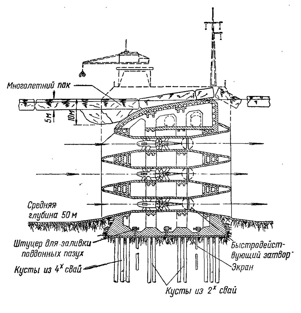
As a spare measure, it was proposed to pre-blacken the ice cover to enhance its melting, to carry out bubbling, stabbing the cover with icebreakers and explosions. In the extreme case, the pumps of the upper tier could be started up in the opposite direction in order to squeeze the ice fields from the dam.
The project was supposed to be international, because the climate was improving not only in the USSR, but also in Canada, the USA, and other countries. According to the authors, the construction with due sense of purpose could be accomplished in 8-10 years.
The expected power required for pumping water is 25 million kW, capital expenditures are 22 billion rubles, including the construction of power plants to supply the dam with electricity, locks and two cities with 50 thousand people each.
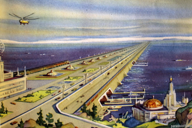
When the Arctic ices melt, the energy consumption of the pumps had to be halved. At this stage, the streamlined top of the dam was supposed to be dismantled and the railroad and the USSR-US highway were there.
Source: https://habr.com/ru/post/394451/
All Articles