Meteorologists have discovered the ability of the ocean to predict extreme heat for 50 days before its arrival on the mainland
Meteorologists from the US National Center for Atmospheric Research (NCAR) associated the formation of characteristic structures on the heat map of the Pacific Ocean with periods of unusually intense heat on the east coast of the United States. These phenomena can predict upcoming temperature rises 50 days before they occur.
The task of predicting the weather is extremely difficult, since atmospheric phenomena obey the laws of nonlinear dynamic systems subject to dynamic chaos . The final state of the system depends very much on the initial parameters, and with the slightest change in them changes very much. A well-known example of the description of the behavior of such systems is the " butterfly effect ".
')
Modern meteorology with the help of supercomputers can calculate more or less reliable forecasts for periods of up to 5-7 days. Medium-term forecasts (up to 10 days) are justified on average by 65-80%.
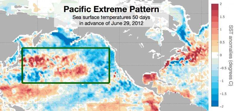
Analyzing the data obtained from meteorological satellites, scientists found that the areas appearing in the Pacific Ocean with a very strong contrast of surface water temperatures often precede the rise in temperature on the coast. The appearance of a certain picture on the temperature map increases the likelihood of extreme heat in a certain number of days three times.
“Summertime heat waves are some of the most dangerous natural phenomena that have a strong influence on farmers, energy, and other important aspects of society,” explains Karen McKinnon, NCAR researcher and lead author. “If we can warn the city authorities and farms about the approach of extreme temperatures, we will be able to avoid very serious consequences.”

June 29, 2012 was the hottest day for the eastern United States in history.
In searching for dependencies between the intense heat in the eastern states and the state of the world ocean, scientists stumbled upon a characteristic pattern — extreme temperatures on the continent are usually preceded by the appearance of a certain picture in one of the places in the Pacific Ocean, at about 20 degrees north latitude.
Dependency check occurred with the processing of data collected by 1,613 weather stations in the periods from 1982 to 2015. Extremely hot days were considered when the temperature rose more than 6.5 C above the average. Scientists took heat into account in summer periods from June 24 to August 22.
The emerging temperature patterns on the ocean surface were able to predict a week of extreme heat 50 days before its occurrence, and a specific day this week - 30 days before its arrival. While scientists find it difficult to say exactly which mechanisms lead to the emergence of such an unusual relationship.
The first-ever weather forecast appeared on August 1, 1861, in the Times newspaper, written by Robert Fitzroy , officer of the British Navy, Beagle expedition commander, in which Charles Darwin, Governor-General of New Zealand, founder and head of the Meteorological Department, took part . Subsequently, due to the inaccuracy of his predictions, he committed suicide.
Source: https://habr.com/ru/post/392355/
All Articles