GPS navigation in Israel with a smartphone
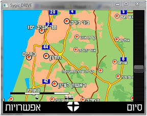
Until recently, the owners of smartphones (those that can call and the screen is not a touch-screen) were unfairly offended by the manufacturers of GPS-navigation programs. On handheld computers (PPC) there have long been run-in solutions like iGO and Destinator, but a decent bundle of the program + map of Israel was not observed. It was not observed until a solution from the Czech company sygic under the straightforward name Sygic Drive was found on the vast expanses of the Internet. Although the choice of supported platforms is impressive (smartphones, PPC, Symbian, Win-platform, Linux), we’ll dwell only on the solution for smartphones.
Benefits
 So, the first and most important moment - “it” works. We will talk about the shortcomings of the current version a bit later, but for now you can fully enjoy the awareness of the fact that you can finally use “smart phones” in our Palestinians as really smart. Why did I emphasize our Palestinians? Yes, because TomTom has long been a solution for smart, but (!) Only for the countries of the setting sun.
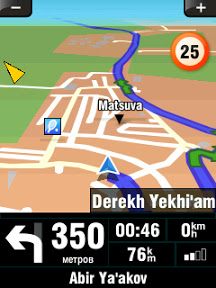
 The second moment - Sygic Drive works correctly both with the built-in GPS receiver (judging by the comments on the relevant forums) and with the external one (checked personally on HTC Dash / s620 WE6, as in the picture on the left, with the BT-77 bluetooth GPS receiver) .
')
The third moment, still positive - Sygic Drive is very moderate in the battery, although it seemed to me that this was the cause of one of the shortcomings.
Since we have already mentioned the shortcomings - let's move on to the enumeration of these. As far as possible, I will try to analyze what exactly is the cause of this or that deficiency: the version of the program, the version of the card, or the hardware on which everything runs.
disadvantages
First, in the current version of the map of Israel (version 7.54 under the smartphone) there are only streets, there is no numbering of houses. The strangeness is that in the cards for the same Sygic Drive under Symbian numbering, although partial, is still present. So this question can be classified as temporary flaws, and its reasons are clear.
Secondly, the route calculation algorithm is clearly not optimized. Calculate the road to 10-15 kilometers takes three or four minutes, and this is an obvious bust. Comparing with the iGO algorithm, which runs at times faster (even taking into account the difference in the CPU in both cases - 200MHz vs. 532MHz), the developers from Sygic still have something to do. Such a long calculation time introduces particular inconvenience if you miss the right turn while driving - the new route will be calculated after you pass not only the next right turn, but a couple of times after it, and the new route will have time to become irrelevant again , because you continue to move in a certain direction, and not to stand still. This way of solving the problem (stopping for a couple of minutes in order to get a new route) is clearly not acceptable from any point of view and one would like to hope that in future versions the situation will be better.
Thirdly, the hint mechanism when moving is a bit buggy. When moving slowly, the name of the street (white letters in a black rectangle), on which it will be necessary to turn, neatly pops up above the intersection on the map. When driving fast, such as on a freeway, the same black rectangle very precisely closes the very center of the map, leaving the driver highly intrigued where exactly to turn.
Fourthly, the map is drawn by jumps during movement, which does not greatly affect the functionality, but to some extent unaesthetic. The reason for this behavior, it seemed to me, was in the desire of developers to load as little as possible and so weak in most cases, the smartphone processor, which ultimately had a positive effect on the battery life when working with the discussed GPS navigation program.
Fifthly, voice prompts are often contrary to the graphic instructions on the screen. The screen always displays the correct information, so it’s impossible to hope only for hearing while driving in unfamiliar terrain. And since we need GPS only where we don’t know the road, (right?), We’re adding a bold (I hope that temporary) version of the current version of Sygic Drive.
Additional functions
Sygic Drive offers a number of additional, but not very necessary functions:
- information on allowed speeds in all countries
- unit converter
- Time Zones
- GPS tracking
- POI: there are some, you can not find the nearest :(, but you can set a warning signal when approaching the POI of a pre-selected type (gas station, police station, train station, etc.)
- theoretical possibility to consider traffic (in Israel does not work)
- night mode
- multi-lingual support
- reconfiguration of the function buttons under the left-handed
- A rather oddly working warning function of exceeding the maximum speed. The oddity lies in the fact that from where Sygic Drive takes the concept of what is the maximum allowed speed, it remains a mystery to me. During the route along highway No. 6, the allowed limit changed according to the program from 95 to 110 km / h. An additional bug that is imposed on this function, making it even less sane, is determining the current speed of the car. For some reason, with fast movement, the program always showed a speed of 10 km / h less than it actually is.
Well, it's time to sum up. In general, we are offered a solution that, although it frankly pleased me as a smart owner, in my subjective opinion deserves the title of the average "beta". Although the basic functions work, a very long miscalculation of the route and incorrect voice prompts do not allow to translate it into a full-fledged class, such as iGO 6.
Functionality: 4 of 5
Reliability / Trust: 3 out of 5
Can be used? If there is no Destonator-a or iGO, then yes
Briefly: Hopefully
Source: https://habr.com/ru/post/37705/
All Articles