Satellites and drones find traces of ancient civilizations
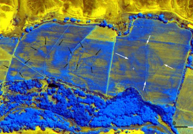
In 2008, scientists were able to detect a large number of ancient pyramids under a layer of soil in the desert of Peru, combining images of Google Earth with infrared photography
Thousands of years ago, quite advanced civilizations existed on Earth, which then disappeared. Archaeologists have long been studying the traces of these ancient cultures, but a serious step forward has been made thanks to modern photography techniques and computer processing of photographs.
At the 2015 AAAS conference, which ends today in San Jose, they discussed “unprecedented opportunities” to explore our historical past with the help of satellite photography and unmanned aerial vehicles.
If earlier traces of ancient civilizations were found almost by accident, now scientists are organizing targeted surveys in remote, lifeless regions, where human culture used to flourish. For example, the Sahara desert or the forests of Amazonia.
')
“Although the Amazonia and the Sahara seem so different, many questions about these areas are actually the same,” says David Mattingly, an archaeologist from the University of Leicester (United Kingdom). He studies the culture of the Garamantes , the ancient people of the Sahara, who began to build a network of cities, fortresses and farmland around the oases in the Sahara in the area of present-day southern Libya, around 1000 BC. Civilization reached its peak of about 0 g and fell into decline after 700 g, when it exhausted groundwater reserves.
The habitat of garamantov is very difficult to study on the spot. These are the remote, lifeless lands of the Sahara, where it is difficult to organize a scientific expedition. Therefore, many artifacts remain unexplored, but in all their glory they appear to scientists in satellite photographs . “An analysis of the area of about 2500 km 2 revealed 158 large settlements, 184 cemeteries, 30 km 2 fields, plus a variety of irrigation systems,” says Mattingli.
Thanks to satellite imagery, a group of archaeologists can select the most promising places for further study and build a map of the area where the Garamant lived.
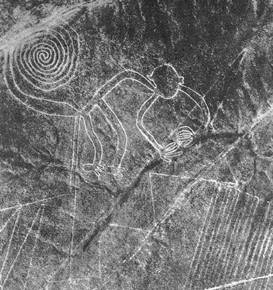
Satellite imagery from Google Earth has already helped make a number of scientific discoveries . For example, the ancient pyramids in the Peruvian desert (in the first photo) were found under a wheat field, one kilometer from the famous Nazca geoglyphs - groups of giant geometric figures, each one hundred meters in size (triangles, spirals, bird, monkey, spider, flowers). These geoglyphs were noticed only in the 20th century, when an airplane flew over them. Due to the gigantic size of the drawings can not be viewed from the ground.
Similar studies were carried out in the forests of the Amazon with the help of UAVs with lidars . The geoglyphs found there — geometrically regular layers of displaced soil — clearly indicate the presence in antiquity of this territory a relatively advanced civilization .
Source: https://habr.com/ru/post/376549/
All Articles