How to build a cottage village from scratch. Part Two - Land Survey
We continue a series of articles on the creation of a cottage settlement "on the knee." In the previous one, we told how to get land for the construction of a village, having a limited budget. In this article we will talk about all the necessary legal and administrative procedures, through which you need to get through to the bright moment of the first official sale.
This whole process consists of the following steps:
This is a rather complicated and time-consuming business (in addition, some steps require a special license), therefore, to perform it, it is best to contact a competent contractor - some surveying company, which in bulk in each region. Therefore, the information in this article is primarily an educational program for the customer. So that you understand the procedure, can evaluate progress, predict completion dates and prevent mistakes. The material is based on our experience with the village of programmers .
To make a mistake with choosing a good contractor is very easy, the result is a failure to meet deadlines. Moreover, as experienced people say, in some cases, the bill may go not even for months, but for years. Therefore, it is worth the most careful and responsible approach to choosing a contractor.
Here are some tips to avoid this situation and find a good performer:
We now turn directly to the process.
')
Each land plot has two characteristics - category and type of permitted use. Why we need two different characteristics, although they seem to be about the same thing - the IT specialist simply does not understand. Moreover, one does not understand the fact that data on these two characteristics can be stored in different places and at the same time contradict each other.
We are interested in such combinations of the category and type of permitted use that allow the construction of residential buildings.
So - if your site is de jure is already a settlement, you can immediately develop a draft plan. You can try to involve him in the LPH, and not in the individual housing construction at the stage of public hearings.
If your plot is agricultural, then you have two possible ways - to make a dacha cooperative or try to “pull” the plot into a settlement.
The second is possible only if the site is adjacent to the locality. The procedure looks like this:
If you decide to go on the road with dachas, then the procedure is approximately the same -
This is a big and boring document, in which essentially the same picture is chewed many times - how residential areas and roads will be located.
You, as a customer, need to remember the following:
After the development of the project, he is sent to the chief architect of the relevant area for consideration. For the architect will fundamentally get to the bottom of a couple of small things, sending the draft for revision. Each such iteration is at least a week of time. So if your engineer mows down, then this pleasure can take a long time - which once again underlines the importance of choosing the right contractor.
After the architect’s apruve, the document is sent to the public hearing.
This is the most amazing procedure in the whole process. Its essence is to give the local public the opportunity to collectively discuss the development plan of your site. That is, it is assumed that local residents will take a day off at their own expense on the appointed day, will come in ties to the administration of the rural settlement and will give you reasoned advice on the improvement and improvement of the developed planning project.
So that the public can prepare for the event in advance (agree on a day off with the employer, study the document and buy a tie) - the legislation requires that, no later than 30 days, the announcement of the upcoming public hearings should be posted in the official press of the rural settlement.
Of course, no one comes to these “hearings” at all. This is just an extra month, which the law for some reason cuts out from the life of the project. As a result of this event, the head of the settlement issues a record of the hearings and an order approving the draft plan, for example, like this .
These documents should be brought back to the boundary office, after which they will begin to prepare documents for submission to the cadastral chamber.
Passing a public hearing is an extremely important checkpoint for a village project. From this point on, you can be sure that all points and borders indicated on the survey project will no longer change. Therefore, it is possible to order the removal of points in nature, to begin work on roads and other communications, as well as to sell plots under a preliminary contract of sale.
At this stage, your contractor prepares documents for submission to the cadastral chamber. This is a purely technical matter, which should take 1-2 weeks. If everything goes smoothly, in the cadastral chamber you will have to give out a pack of cadastral passports - one for each small delimited area. This pack should be taken away and independently brought to the registration chamber, where within 30 days you should produce and issue long-awaited certificates of ownership.
Work on the village sometimes resembles a very confusing quest. It's a shame that most of the energy that could have been channeled in a more constructive way had to be spent on solving some kind of stupid questions created by the legislation in this area out of the blue.
It’s still important for us to reach the end, overcoming all these obstacles - and at the same time help people who will repeat this path. There are a lot of uncoordinated and contradictory information on the Internet, and there is no single tutorial for creating a village from scratch. If you are engaged in a similar matter and are stuck on one of the stages - write to us, with pleasure we will share our modest experiences so far.
As usual, you can follow our news on Twitter and Instagram . The next article of the cycle is about the engineering communications of the village.
This whole process consists of the following steps:
- Transfer of a site to the necessary category;
- Development of the draft plan, combined with the draft survey;
- Public hearings;
- Reception of cadastral passports;
- Obtaining certificates of ownership.
This is a rather complicated and time-consuming business (in addition, some steps require a special license), therefore, to perform it, it is best to contact a competent contractor - some surveying company, which in bulk in each region. Therefore, the information in this article is primarily an educational program for the customer. So that you understand the procedure, can evaluate progress, predict completion dates and prevent mistakes. The material is based on our experience with the village of programmers .
Contractor selection
To make a mistake with choosing a good contractor is very easy, the result is a failure to meet deadlines. Moreover, as experienced people say, in some cases, the bill may go not even for months, but for years. Therefore, it is worth the most careful and responsible approach to choosing a contractor.
We in the village of programmers made a choice that was wrong, which, in principle, tore us to the summer construction season of 2014. We trusted a large office that "specializes" in our area. All work on the first section should have been completed in 3 months (i.e. by mid-June 2014), but at the time of this writing, they are still underway - although they are already at the final stage. Those. by the time they have moved at least three times.
Here are some tips to avoid this situation and find a good performer:
- Pay more attention to negative reviews, not positive ones. Try to find a real client of this company who needed to do exactly the same thing as you.
- Do not pay attention if you hang noodles about connections in some coordinating bodies - as a rule, everyone who works in this market has such connections.
- Prefer small and hungry. The fat promoted company, maybe, will take cheaper - but it will not give a damn about your order. You will be assigned an engineer, on whom a dozen of the same orders are already hanging, for which the customers have already begun to be nervous - therefore your priority will not be the highest.
- If you can’t find a small contractor and you still have to go to a large company, ask the contract to increase the maximum amount of the penalty. Usually it is limited to 10% of the order amount - try to raise this bar as high as possible. This should motivate them to take responsibility for your order.
We now turn directly to the process.
')
1. Transfer of a site to the necessary category
Each land plot has two characteristics - category and type of permitted use. Why we need two different characteristics, although they seem to be about the same thing - the IT specialist simply does not understand. Moreover, one does not understand the fact that data on these two characteristics can be stored in different places and at the same time contradict each other.
An example - a rural settlement at a meeting of its “Duma” decides to include a plot with the category of “agricultural use” in the line of the settlement and issues all the necessary documents. The cadastral chamber does not know anything about this and continues to consider the plot as agricultural. This situation can last for years, until someone starts to work with the site. The state bodies themselves do not know how to share such information.
The characteristics of the site according to the cadastral chamber are available online on the Rosreestr site - http://maps.rosreestr.ru/PortalOnline/ .
We are interested in such combinations of the category and type of permitted use that allow the construction of residential buildings.
| Category | Type of permitted use | Comment |
|---|---|---|
| Earth settlements | Individual residential construction (IHC) | The most common option. The tax rate is 1.5% of the cadastral value per year. |
| Earth settlements | Private farm (LPH) | The coolest option, but it is difficult to achieve. Allows all the same thing as IH, Only the tax rate is five times less - only 0.3% of the cadastral value per year. |
| Farm | For conducting country economy | Also an acceptable option. Recently, in such houses you can even register. Paper movements on this option is much less. Objectively, there are no drawbacks, but for everyone this way for some reason causes concern. |
So - if your site is de jure is already a settlement, you can immediately develop a draft plan. You can try to involve him in the LPH, and not in the individual housing construction at the stage of public hearings.
If your plot is agricultural, then you have two possible ways - to make a dacha cooperative or try to “pull” the plot into a settlement.
The second is possible only if the site is adjacent to the locality. The procedure looks like this:
- Write a statement addressed to the head of the rural settlement - please include the parcel with such and such cadastral number in the settlement.
- If there are no sufficient grounds for refusal, then at the next meeting of the local rural “Duma” an order is issued on a corresponding change in the general plan of the rural settlement;
- You go with this order to the land survey office, which originally developed this general plan, pay them - and wait another six months while they paint the plot in yellow in their file and carry the updated piece of paper to all authorities.
If you decide to go on the road with dachas, then the procedure is approximately the same -
- Forming abstract TSN with relatives or proxies;
- You make a donation of your land to this TSN;
- On behalf of TSN, you turn to a land survey office, which will carry out all the further steps of surveying. Compared with the lands of settlements, these steps will be cheaper and can be completed much faster.
In our case, one of the plots purchased under the village was already drawn into the settlement, and the other two were related to agricultural land. With these two others, we decided to follow the path of joining them to the locality, deciding not to risk it with a less predictable dacha.
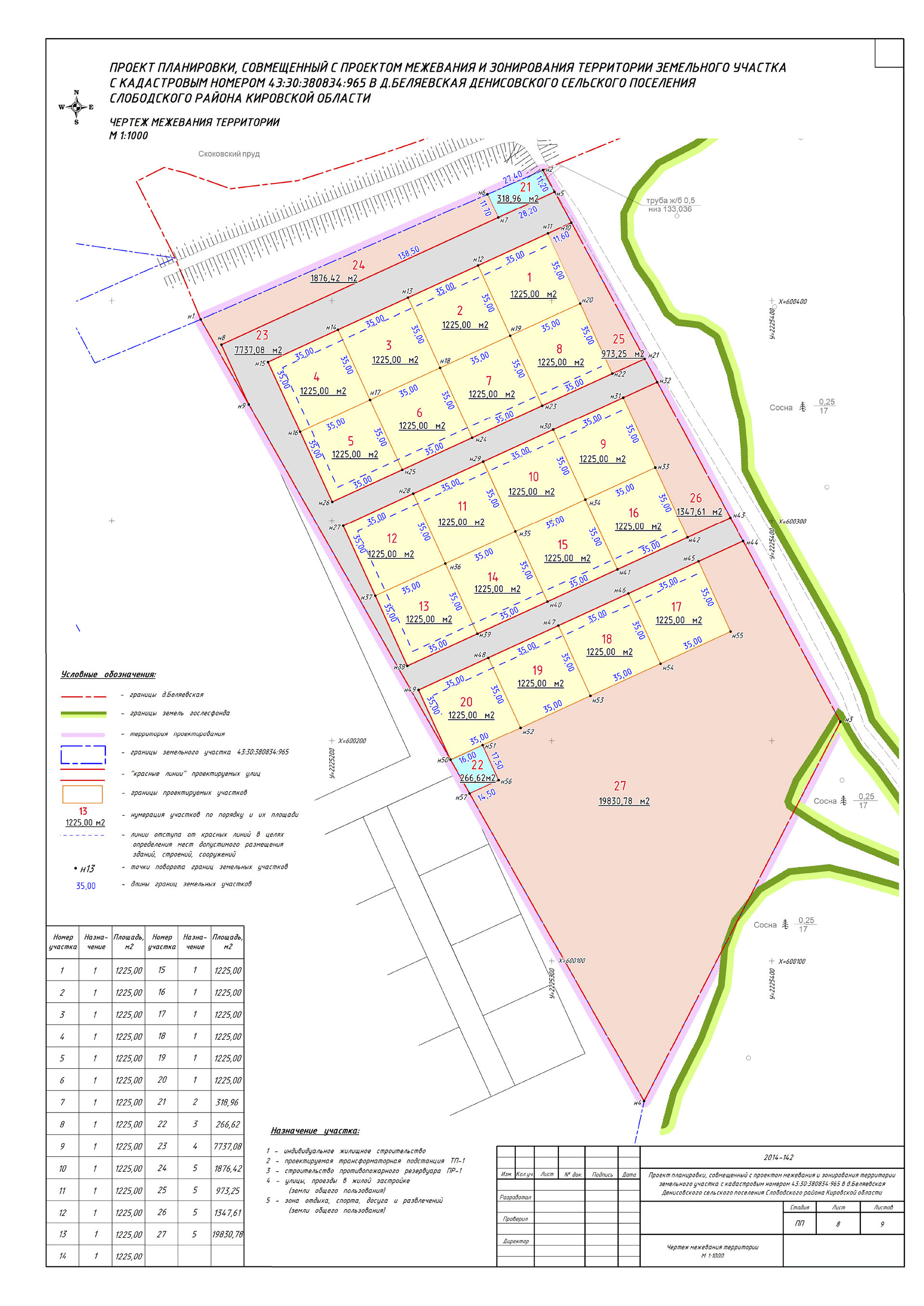
2. Development of the draft plan, combined with the draft survey
This is a big and boring document, in which essentially the same picture is chewed many times - how residential areas and roads will be located.
You, as a customer, need to remember the following:
- The development of the document will be engaged in cadastral engineers. They do not care about usability, design and generally your whole village. They understand only the language of building codes and rules and want them to quickly fall behind. Therefore, you need to work in advance with the designer / architect, who will develop the layout of the village and put it on the map as accurately as possible - and give this layout to the engineers as a TK.
- Engineers are accustomed to the fact that customers usually do not care about their village either - for the majority it’s just another piece of land that needs to be sold off as quickly as possible. Therefore, they may not take your requirements quite seriously for some of your fundamental requirements. So that this does not go too far, constantly demand intermediate results from them and check whether everything is appropriate.
- The development of the most sophisticated plan can not take the engineer more than 2-3 weeks, if he works on a full time project. If you are not given a project in 3 weeks, ready to be sent for approval, then get nervous and demand.
The engineer, who was entrusted to develop the project of our village, decided that the requirement to make all the residential areas of squares 35 x 35 meters, orienting parallel to the shore of the pond is the customer's whim. Instead of the shore of the pond, he perceived only the curved boundaries of the original cadastral parcel. Therefore, in the first version, the sections turned out to be parallelograms with a bevel of about 15 degrees. The result is another month of lost time.
After that, we worked with the architect and formed our vision of the layout in the form of such a kmz file in Google Earth, which we use as the TK. Detailed planning is described in the article http://semanticle.com/za32

After the development of the project, he is sent to the chief architect of the relevant area for consideration. For the architect will fundamentally get to the bottom of a couple of small things, sending the draft for revision. Each such iteration is at least a week of time. So if your engineer mows down, then this pleasure can take a long time - which once again underlines the importance of choosing the right contractor.
After the architect’s apruve, the document is sent to the public hearing.
3. Public hearings
This is the most amazing procedure in the whole process. Its essence is to give the local public the opportunity to collectively discuss the development plan of your site. That is, it is assumed that local residents will take a day off at their own expense on the appointed day, will come in ties to the administration of the rural settlement and will give you reasoned advice on the improvement and improvement of the developed planning project.
So that the public can prepare for the event in advance (agree on a day off with the employer, study the document and buy a tie) - the legislation requires that, no later than 30 days, the announcement of the upcoming public hearings should be posted in the official press of the rural settlement.
Of course, no one comes to these “hearings” at all. This is just an extra month, which the law for some reason cuts out from the life of the project. As a result of this event, the head of the settlement issues a record of the hearings and an order approving the draft plan, for example, like this .
These documents should be brought back to the boundary office, after which they will begin to prepare documents for submission to the cadastral chamber.
Passing a public hearing is an extremely important checkpoint for a village project. From this point on, you can be sure that all points and borders indicated on the survey project will no longer change. Therefore, it is possible to order the removal of points in nature, to begin work on roads and other communications, as well as to sell plots under a preliminary contract of sale.
4. Final stage
At this stage, your contractor prepares documents for submission to the cadastral chamber. This is a purely technical matter, which should take 1-2 weeks. If everything goes smoothly, in the cadastral chamber you will have to give out a pack of cadastral passports - one for each small delimited area. This pack should be taken away and independently brought to the registration chamber, where within 30 days you should produce and issue long-awaited certificates of ownership.
We are in the final stage right now, and things are not going smoothly with us. Public hearings took place at the end of September, and the process has not yet been completed. In addition to the fact that the contractor again slowed down with the engineering part, two factors played a role:
- In the cadastral chamber there was no information that the site was included in the territory of the settlement (although the official change of the general plan was already in 2012).
- When changing the permitted use of plots on IZhS, clarification of their boundaries is required up to a maximum permissible error of 10 cm.
If we had known about these details before, both of these processes could have been launched in parallel, and by now they would have been completed.
PS
Work on the village sometimes resembles a very confusing quest. It's a shame that most of the energy that could have been channeled in a more constructive way had to be spent on solving some kind of stupid questions created by the legislation in this area out of the blue.
It’s still important for us to reach the end, overcoming all these obstacles - and at the same time help people who will repeat this path. There are a lot of uncoordinated and contradictory information on the Internet, and there is no single tutorial for creating a village from scratch. If you are engaged in a similar matter and are stuck on one of the stages - write to us, with pleasure we will share our modest experiences so far.
As usual, you can follow our news on Twitter and Instagram . The next article of the cycle is about the engineering communications of the village.
Source: https://habr.com/ru/post/376071/
All Articles