Independent city: 3 technologies of "reasonable" traffic management
Urban problems, such as traffic jams, can be solved in a conservative way, that is, by physically increasing the capacity of roads, or by “reasonable” (from English smart). In this case, all transport and people are united in an ecosystem, and the city itself “decides” how to distribute transport flows. We spoke about our vision of such an ecosystem in one of the “Open Innovation” forums. And in this article we will discuss how exactly the “smart” traffic management systems work and why they are so important for all of us.
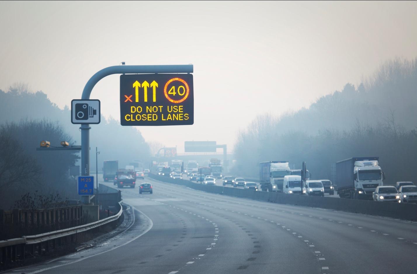
Photo Highways England / CC
According to WHO, more than 50 percent of the world's population lives in cities. Metropolitan areas for the most part suffer from transport problems. Traffic jams are their most obvious and frequent manifestation. They negatively affect local economies and the quality of life of all road users, therefore, of course, they require elimination.
')
If, as an example, to consider the typical cause of traffic jams - repair work - a conservative approach to its solution would be to redirect traffic to the nearest parallel roads. As a result, most likely, they will be overloaded after the main highway, and not a single free lane will remain near the site being repaired during rush hours.
Of course, the authorities will try to build a forecast on which roads a traffic jam will occur faster. To do this, they will take into account the presence of traffic lights at intersections, average traffic congestion and other static factors. However, at the moment when the 8-point traffic jam paralyzes the city center, it is unlikely that you will be able to do something other than “manually controlling” the situation, for example, by turning off the traffic lights and replacing them with an urgent servant-regulator.
There is another scenario for the development of the same plot. In a “smart” city, data comes not only from traditional sources, but also from sensors and devices, both installed inside the cars themselves and protruding elements of the infrastructure. Information about the location of vehicles allows reallocation of traffic in real time, and additional systems, such as smart traffic lights and parking, provide efficient traffic management.
A sensible approach has become the choice for a number of cities and has proven its effectiveness. In German Darmstadt, sensors help ensure the safety of pedestrians and the absence of traffic jams. They discover large groups of people who are about to cross the road, and adapt the change of traffic light phases for them. In addition, they determine whether there is a stream of cars nearby, and “give the command” to switch the light only when the cars have finished moving.
And the traffic distribution system in the Danish city of Aarhus not only reduced traffic jams, but also reduced overall fuel consumption. London's intellectual system notifies drivers of congestion on certain road sections. The smart traffic management system helped Singapore to become one of the least busy cities in the world.
The key tool of a “smart” city is data. Therefore, the heart of the system is a platform that integrates all the information flows in real time, interprets them and makes an independent decision about traffic control (or helps to make such a decision to the responsible person). As a rule, a traffic control command center is formed around the platform.
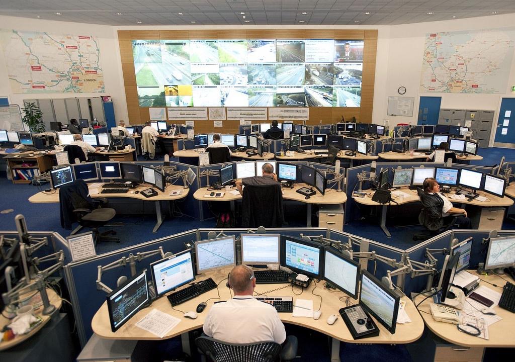
Photo Highways England / CC
A geographic information system (GIS) provides an opportunity to link data with specific points on a roadmap. For direct control of the movement are separate subsystems. Their number, complexity and levels of interaction with each other may differ in different models depending on the tasks.
For example, the following subsystems operate in Chinese Langfang: traffic lights, traffic information, surveillance and warning, geolocation positioning of official cars and other components. In Romanian Timisoara, besides the elements already described, the subsystems of prioritizing public transport and license plate recognition are implemented .
The system of “smart” distribution of traffic flows can be complicated by various elements, but the main one in it is the platform that manages all subsystems based on the incoming data. From this point of view, cars are an important component of any model of a “reasonable” city. They are not only able to receive information (using devices such as, for example, WayRay Navion) and adapt to a specific traffic situation, but also act as suppliers of significant traffic information.
We propose to consider in more detail the design of the most important subsystems of the "reasonable" city.
Monitoring is the basis of the work of the command center. Timely detection of incidents and response to them guarantees safety on the roads and reduced traffic jams. The user most often sees the results of monitoring on a map with a color scheme that displays the traffic load in real time.
The data sources are cameras, which automatically analyze the situation on the roads as vehicles move in their area of operation, as well as piezoelectric sensors. Another way to monitor the smart city ecosystem is to track a stream based on a wireless signal, for example, from Bluetooth devices.
For example, the variant proposed by Libelium is able to differentiate signals from various devices, including pedestrian phones. The received sensor data is transmitted to the server, where, after analysis, the system (if necessary) makes a decision to eliminate the overload of automobile or pedestrian traffic.
The same concept is also implemented with the help of wider groups of sensors combined in a network. The basic principle of operation - the sensor or sensor identifies the vehicle by comparing the signals in the absence and presence of an obstacle / jam / traffic jam. The base station calculates the speed based on the distance between the two sensor nodes and the average time they pass by the car.
An example of how such a system works is described by Mathieu Dumoulin, a data processing specialist from MapR Data Technologies. The scheme of work with sensor signals, proposed by MapR, is based on the assignment of rules to events that occur during streaming data transfer, for example, to information about incidents in certain sections. The business rules proposed by the Mathieu team make it possible to apply useful actions in response to them.
To demonstrate the work of their approach, MapR modeled the traffic situation with a single sensor measuring the speed of passing vehicles to detect congestion and inform the command center. The use of data on accidents that have already occurred at the site and the connection of analytics modules help to monitor the situation and make effective decisions on resolving road incidents in real time.
In an urban rational ecosystem, monitoring is valuable, firstly, from the point of view of the authorities ’timely response, and secondly, as an additional channel of communication with drivers. As noted in MapR, real-time data can flow not only to the command center, but also to information panels along the roads. Combining information about road congestion with augmented reality systems inside cars will help in compiling important tips, forecasts and driving directions.

Photo by Matthias Ripp / CC
The principle of operation of this subsystem is simple: the so-called "adaptive" traffic lights use tools to measure the amount of traffic that signals the need for a phase change. When traffic is obstructed, the green phase of the traffic light for cars is active longer than usual. During peak periods, traffic lights at intersections synchronize their phases so as to provide “green corridors” for transport.
In a “sensible” city, the system is complicated by the complex of sensors that transmit data to the algorithms for analysis. In Tyler, Texas, such a solution as part of Siemens’s integrated traffic management system reduced traffic delays by 22%. Travel time on one of the main thoroughfares of Bellevue, Washington, was reduced by 36% during peak hours since the installation of adaptive traffic lights.
This is how the subsystem functions in its basic embodiment: infrared sensors installed in one of the road infrastructure elements, for example, in light supports, detect the occurrence or absence of automobile traffic. This data serves as an input signal for a system that generates output signals for the red, green and yellow phases and controls the cycle time, taking into account the number of vehicles on each road.
The same information as the output signal can be transmitted to the road user. Adaptive traffic lights can also work in emergency mode, when video fixers recognize a moving vehicle as an ambulance or a police car with signal beacons turned on. In this case, for cars that cross the route of the company car, the traffic lights will change to red.
Input data sources for the system can also serve as cameras that recognize the amount of traffic. In the integrated model of a “reasonable” city, information from the cameras about the situation on the road is transmitted simultaneously to the software environment for algorithmic processing and to the control system, where it is visualized and displayed on screens in the command center.
There are variations of "smart" traffic lights. For example, artificial intelligence technologies improve the coordination of road signals in a single ecosystem. In this case, the sensors and cameras also trigger the cycle. AI algorithms use the data to create looping timing, effectively passing the flow along the path, and provide information to the following traffic lights. However, such a system remains decentralized, and each traffic light "makes its own decisions" for the duration of the phases.
Researchers at Nanyang Technological University this year presented a traffic distribution algorithm based on machine learning. Routing in this case has several nuances : it takes into account the current load on the transport system and the predicted unknown value, which is responsible for the additional load that can enter the network at any time. Further, the algorithm is responsible for unloading the network at each node or, in other words, the intersection. Such a system in conjunction with traffic lights with artificial intelligence can be a solution for common urban problems.
Smart traffic lights play an important role for drivers, not only because of the obvious effect — reducing the number of traffic jams — but also because of the feedback that comes from user devices such as WayRay Navion. For example, drivers in Tokyo receive signals from infrared sensors directly to navigators, which build an optimal route based on this.
The same happens in Edmonton, Canada, where the on-board computer of the car is notified by sound or text message about the imminent phase change of the traffic light. In Pittsburgh, Pennsylvania, where traffic lights are endowed with intelligence, the main task of the research team is to establish the connection between the system and the car. Adaptation of navigators for information received from traffic lights is the future of driving.
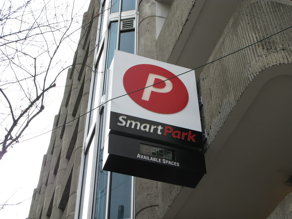
Photo Oran Viriyincy / CC
The lack of parking spaces or their inefficient use is not just a domestic problem, but a challenge for the urban infrastructure and another reason for congestion. According to Navigant Research, the number of “smart” parking spaces in the world is expected to reach 1.1 million by 2026. They are distinguished from ordinary parking by automated systems for searching for free places and informing users.
As one of the solutions to the problem, the Rice University team developed a model that uses a camera to take available photos every minute to search for free space. Then they are analyzed using the object detection algorithm. However, within the ecosystem of a "reasonable" city, this solution is not optimal.
A “smart” parking system should not only know the status of each place (“busy / free”), but also be able to direct the user to it. Devavrat Kulkarni, senior business analyst at IT company Maven Systems, suggests using a sensor network.
Information obtained from them can be processed by the algorithm and presented to the end user through an application or another user interface. At the time of parking the application stores information about the location of the vehicle, which simplifies the search for a car in the future. This solution can be called local, suitable, for example, for individual shopping centers.
Really large-scale projects in this area are being implemented right now in some US cities. The initiative to deploy a single network of "smart" parking LA Express Park is held in Los Angeles. StreetLine startup, which is responsible for the realization of the idea, uses machine learning methods to combine several data sources - sensors and surveillance cameras - into a single channel for transmitting information about the employment of parking spaces.
These data are considered in the context of the parking system throughout the city and come to the responsible persons. StreetLine provides the SDK, an automatic license plate recognition system and an API for working with all parking-related data sources.
Intelligent parking systems can also be useful for controlling traffic density. The basis of this decision is the advancement of the traffic control instrument - the change in tariff rates in paid parking areas. This allows you to distribute the load of parking spaces on certain days, thereby reducing traffic jams.
For end users, data on available seats and cheaper fares help plan a trip and generally improve driver's experience qualitatively - with the help of wearable or car-embedded devices, the user gets practical instructions on finding a parking space in real time.
The three main elements considered by us are a ready-made ecosystem that can significantly ease the situation on the roads of a modern city. However, the infrastructure of the future is created primarily for the transport of the future. Automated monitoring, parking and control systems facilitate the transition to the use of unmanned vehicles.
However, this is not so simple: the infrastructure, which is used in “smart” cities now, may not be necessary for drones. For example, if today there is still a sense in changing the phases of a traffic light, then, according to researchers at the Massachusetts Institute of Technology, unmanned vehicles we do not need the usual signals at all - the speed of vehicles and stopping at intersections will be automatically carried out using sensors.
Probably even the most advanced traffic management systems will survive a global modernization after drones push traditional cars off the roads and we will see a new world without traffic lights, traffic cameras and speed bumps. However, until the full transition to unmanned cars is unlikely. But the increase in the number of "reasonable" cities is a very real prospect.
Photo Highways England / CC
Why do cities need a smart transportation system?
According to WHO, more than 50 percent of the world's population lives in cities. Metropolitan areas for the most part suffer from transport problems. Traffic jams are their most obvious and frequent manifestation. They negatively affect local economies and the quality of life of all road users, therefore, of course, they require elimination.
')
If, as an example, to consider the typical cause of traffic jams - repair work - a conservative approach to its solution would be to redirect traffic to the nearest parallel roads. As a result, most likely, they will be overloaded after the main highway, and not a single free lane will remain near the site being repaired during rush hours.
Of course, the authorities will try to build a forecast on which roads a traffic jam will occur faster. To do this, they will take into account the presence of traffic lights at intersections, average traffic congestion and other static factors. However, at the moment when the 8-point traffic jam paralyzes the city center, it is unlikely that you will be able to do something other than “manually controlling” the situation, for example, by turning off the traffic lights and replacing them with an urgent servant-regulator.
There is another scenario for the development of the same plot. In a “smart” city, data comes not only from traditional sources, but also from sensors and devices, both installed inside the cars themselves and protruding elements of the infrastructure. Information about the location of vehicles allows reallocation of traffic in real time, and additional systems, such as smart traffic lights and parking, provide efficient traffic management.
A sensible approach has become the choice for a number of cities and has proven its effectiveness. In German Darmstadt, sensors help ensure the safety of pedestrians and the absence of traffic jams. They discover large groups of people who are about to cross the road, and adapt the change of traffic light phases for them. In addition, they determine whether there is a stream of cars nearby, and “give the command” to switch the light only when the cars have finished moving.
And the traffic distribution system in the Danish city of Aarhus not only reduced traffic jams, but also reduced overall fuel consumption. London's intellectual system notifies drivers of congestion on certain road sections. The smart traffic management system helped Singapore to become one of the least busy cities in the world.
What is the "smart" motion control system
The key tool of a “smart” city is data. Therefore, the heart of the system is a platform that integrates all the information flows in real time, interprets them and makes an independent decision about traffic control (or helps to make such a decision to the responsible person). As a rule, a traffic control command center is formed around the platform.
Photo Highways England / CC
A geographic information system (GIS) provides an opportunity to link data with specific points on a roadmap. For direct control of the movement are separate subsystems. Their number, complexity and levels of interaction with each other may differ in different models depending on the tasks.
For example, the following subsystems operate in Chinese Langfang: traffic lights, traffic information, surveillance and warning, geolocation positioning of official cars and other components. In Romanian Timisoara, besides the elements already described, the subsystems of prioritizing public transport and license plate recognition are implemented .
The system of “smart” distribution of traffic flows can be complicated by various elements, but the main one in it is the platform that manages all subsystems based on the incoming data. From this point of view, cars are an important component of any model of a “reasonable” city. They are not only able to receive information (using devices such as, for example, WayRay Navion) and adapt to a specific traffic situation, but also act as suppliers of significant traffic information.
We propose to consider in more detail the design of the most important subsystems of the "reasonable" city.
Intelligent Monitoring and Response System
Monitoring is the basis of the work of the command center. Timely detection of incidents and response to them guarantees safety on the roads and reduced traffic jams. The user most often sees the results of monitoring on a map with a color scheme that displays the traffic load in real time.
The data sources are cameras, which automatically analyze the situation on the roads as vehicles move in their area of operation, as well as piezoelectric sensors. Another way to monitor the smart city ecosystem is to track a stream based on a wireless signal, for example, from Bluetooth devices.
For example, the variant proposed by Libelium is able to differentiate signals from various devices, including pedestrian phones. The received sensor data is transmitted to the server, where, after analysis, the system (if necessary) makes a decision to eliminate the overload of automobile or pedestrian traffic.
The same concept is also implemented with the help of wider groups of sensors combined in a network. The basic principle of operation - the sensor or sensor identifies the vehicle by comparing the signals in the absence and presence of an obstacle / jam / traffic jam. The base station calculates the speed based on the distance between the two sensor nodes and the average time they pass by the car.
An example of how such a system works is described by Mathieu Dumoulin, a data processing specialist from MapR Data Technologies. The scheme of work with sensor signals, proposed by MapR, is based on the assignment of rules to events that occur during streaming data transfer, for example, to information about incidents in certain sections. The business rules proposed by the Mathieu team make it possible to apply useful actions in response to them.
To demonstrate the work of their approach, MapR modeled the traffic situation with a single sensor measuring the speed of passing vehicles to detect congestion and inform the command center. The use of data on accidents that have already occurred at the site and the connection of analytics modules help to monitor the situation and make effective decisions on resolving road incidents in real time.
In an urban rational ecosystem, monitoring is valuable, firstly, from the point of view of the authorities ’timely response, and secondly, as an additional channel of communication with drivers. As noted in MapR, real-time data can flow not only to the command center, but also to information panels along the roads. Combining information about road congestion with augmented reality systems inside cars will help in compiling important tips, forecasts and driving directions.
Photo by Matthias Ripp / CC
Smart traffic lights
The principle of operation of this subsystem is simple: the so-called "adaptive" traffic lights use tools to measure the amount of traffic that signals the need for a phase change. When traffic is obstructed, the green phase of the traffic light for cars is active longer than usual. During peak periods, traffic lights at intersections synchronize their phases so as to provide “green corridors” for transport.
In a “sensible” city, the system is complicated by the complex of sensors that transmit data to the algorithms for analysis. In Tyler, Texas, such a solution as part of Siemens’s integrated traffic management system reduced traffic delays by 22%. Travel time on one of the main thoroughfares of Bellevue, Washington, was reduced by 36% during peak hours since the installation of adaptive traffic lights.
This is how the subsystem functions in its basic embodiment: infrared sensors installed in one of the road infrastructure elements, for example, in light supports, detect the occurrence or absence of automobile traffic. This data serves as an input signal for a system that generates output signals for the red, green and yellow phases and controls the cycle time, taking into account the number of vehicles on each road.
The same information as the output signal can be transmitted to the road user. Adaptive traffic lights can also work in emergency mode, when video fixers recognize a moving vehicle as an ambulance or a police car with signal beacons turned on. In this case, for cars that cross the route of the company car, the traffic lights will change to red.
Input data sources for the system can also serve as cameras that recognize the amount of traffic. In the integrated model of a “reasonable” city, information from the cameras about the situation on the road is transmitted simultaneously to the software environment for algorithmic processing and to the control system, where it is visualized and displayed on screens in the command center.
There are variations of "smart" traffic lights. For example, artificial intelligence technologies improve the coordination of road signals in a single ecosystem. In this case, the sensors and cameras also trigger the cycle. AI algorithms use the data to create looping timing, effectively passing the flow along the path, and provide information to the following traffic lights. However, such a system remains decentralized, and each traffic light "makes its own decisions" for the duration of the phases.
Researchers at Nanyang Technological University this year presented a traffic distribution algorithm based on machine learning. Routing in this case has several nuances : it takes into account the current load on the transport system and the predicted unknown value, which is responsible for the additional load that can enter the network at any time. Further, the algorithm is responsible for unloading the network at each node or, in other words, the intersection. Such a system in conjunction with traffic lights with artificial intelligence can be a solution for common urban problems.
Smart traffic lights play an important role for drivers, not only because of the obvious effect — reducing the number of traffic jams — but also because of the feedback that comes from user devices such as WayRay Navion. For example, drivers in Tokyo receive signals from infrared sensors directly to navigators, which build an optimal route based on this.
The same happens in Edmonton, Canada, where the on-board computer of the car is notified by sound or text message about the imminent phase change of the traffic light. In Pittsburgh, Pennsylvania, where traffic lights are endowed with intelligence, the main task of the research team is to establish the connection between the system and the car. Adaptation of navigators for information received from traffic lights is the future of driving.
Photo Oran Viriyincy / CC
Smart Parking
The lack of parking spaces or their inefficient use is not just a domestic problem, but a challenge for the urban infrastructure and another reason for congestion. According to Navigant Research, the number of “smart” parking spaces in the world is expected to reach 1.1 million by 2026. They are distinguished from ordinary parking by automated systems for searching for free places and informing users.
As one of the solutions to the problem, the Rice University team developed a model that uses a camera to take available photos every minute to search for free space. Then they are analyzed using the object detection algorithm. However, within the ecosystem of a "reasonable" city, this solution is not optimal.
A “smart” parking system should not only know the status of each place (“busy / free”), but also be able to direct the user to it. Devavrat Kulkarni, senior business analyst at IT company Maven Systems, suggests using a sensor network.
Information obtained from them can be processed by the algorithm and presented to the end user through an application or another user interface. At the time of parking the application stores information about the location of the vehicle, which simplifies the search for a car in the future. This solution can be called local, suitable, for example, for individual shopping centers.
Really large-scale projects in this area are being implemented right now in some US cities. The initiative to deploy a single network of "smart" parking LA Express Park is held in Los Angeles. StreetLine startup, which is responsible for the realization of the idea, uses machine learning methods to combine several data sources - sensors and surveillance cameras - into a single channel for transmitting information about the employment of parking spaces.
These data are considered in the context of the parking system throughout the city and come to the responsible persons. StreetLine provides the SDK, an automatic license plate recognition system and an API for working with all parking-related data sources.
Intelligent parking systems can also be useful for controlling traffic density. The basis of this decision is the advancement of the traffic control instrument - the change in tariff rates in paid parking areas. This allows you to distribute the load of parking spaces on certain days, thereby reducing traffic jams.
For end users, data on available seats and cheaper fares help plan a trip and generally improve driver's experience qualitatively - with the help of wearable or car-embedded devices, the user gets practical instructions on finding a parking space in real time.
Future motion control
The three main elements considered by us are a ready-made ecosystem that can significantly ease the situation on the roads of a modern city. However, the infrastructure of the future is created primarily for the transport of the future. Automated monitoring, parking and control systems facilitate the transition to the use of unmanned vehicles.
However, this is not so simple: the infrastructure, which is used in “smart” cities now, may not be necessary for drones. For example, if today there is still a sense in changing the phases of a traffic light, then, according to researchers at the Massachusetts Institute of Technology, unmanned vehicles we do not need the usual signals at all - the speed of vehicles and stopping at intersections will be automatically carried out using sensors.
Probably even the most advanced traffic management systems will survive a global modernization after drones push traditional cars off the roads and we will see a new world without traffic lights, traffic cameras and speed bumps. However, until the full transition to unmanned cars is unlikely. But the increase in the number of "reasonable" cities is a very real prospect.
Source: https://habr.com/ru/post/374033/
All Articles