Google improved google maps app for pc and mobile
Google Inc. reported on work done to improve the Google Maps application. It is about both the desktop version and applications for mobile devices. According to the corporation, the changes made it easier for the user to work with Maps.
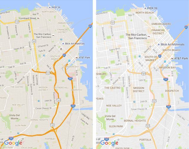
The changes affected the elements that are shown on the maps - the company removed all the minor objects that interfered with the normal perception of maps for the user. Only those elements are left, without which it is impossible to do - for example, roads. The developers believe that now the maps have become much “cleaner”, it is easier for the user to track the right places and objects.
Improved display quality of street names, sights and other elements. Names no longer merge with background or other names.
')

Another important update is the color indication of places that may be interesting to the user. The color for such locations is orange, which is difficult to miss. Interesting locations, according to the corporation, are places where there are a lot of people and places that can be visited. To search for such places you just need to open Google Maps and look around you (more precisely, look in the application for places that are adjacent to the current location of the user).
In the "interesting places" are hotels, subway stations, museums and attractions that would be worth a visit.
The service algorithm independently paints areas, choosing places with the maximum concentration of restaurants, bars and shops. In large cities, for example, New York, the opinion of people about different places is also used.
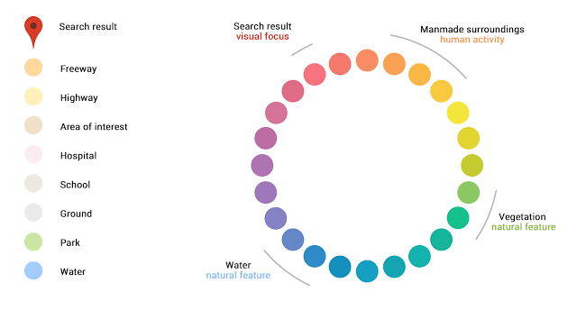
The color scheme of the service has become more sophisticated and accurate, so now you can easily identify places with objects created by people from natural landscapes. It is also easy to find hospitals, schools, highways. The above shows the color scheme with which the algorithm works for coloring different locations.
Over the past few weeks this is the second improvement for the company's map services. In June, Google conducted the most significant update of satellite maps over several years. Many thousands of shots were replaced with photos from Landsat 8.
At the same time, the company applied new techniques for processing and gluing these photos. In particular, the technique of creating a cloudless mosaic has been improved, which is an important improvement, as clouds constantly cover more than half of the entire earth's surface.
The total volume of Landsat 8 satellite imagery used was 1 petabyte. The aggregate resolution is 700 trillion pixels. In order to glue all these photos together, it took the company more than 6 million hours of CPU time. This task was performed on a cluster of 43,000 computers.
Source: https://habr.com/ru/post/372521/
All Articles