Lidars helped discover the thousands of Mayan buildings in the jungles of Guatemala
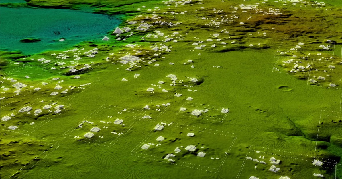
A recent survey of the jungle of Guatemala using laser radar (lidar) helped to detect new Mayan cities that disappeared hundreds of years ago. We are talking about thousands of structures, including houses, irrigation canals, fortifications, and even a pyramid. The total area of the surveyed area is 2000 square kilometers. These lands were studied from a bird's eye view.
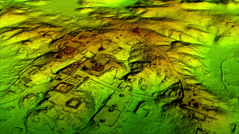
Laser technology in archeology began to be applied relatively recently. It is lasers that make it possible to break through the crowns of trees and see what would remain hidden from human eyes for many more years, or even decades. With the help of lidars, experts examine distant objects using active optical systems that use the phenomena of absorption and scattering of light in optically transparent media.
Scientists studied the jungles of Guatemala using an airplane. After analyzing the data, it turned out that the Mayan civilization may have been much more developed and populous than previously thought. In the jungle hidden about 60 thousand different objects. Needless to say, many archaeologists are almost happy?
')
New data can slightly change our understanding of what the Mayan civilization was. The fact that they were skilled builders, farmers and builders, has long been known. But now images of lidars show thousands of acres covered by irrigation canals, which were undoubtedly used in agriculture.
Historians knew that the Maya had a lot, but could not answer the question of how they could feed themselves. Now this is all explained - with the help of a complex system of irrigation canals and fields located on a large area. True, it is also necessary to answer the question of how and how the Mayans fertilized their land. This question may seem unimportant, but actually answering it means understanding the essence of agriculture of those who lived in Guatemala and other South American modern states hundreds of years ago.
The ancient city of Tikal was much larger than archaeologists had suggested. The first signs of the existence of this city were discovered in the 1960s. According to new research, all the fortifications found earlier were much larger.
“Lidar really found this city network, and now we have a much larger amount of data than before,” said research director Harrison. In some places, the pumping of water was carried out due to the minimum slope - so small that the difference between “exactly horizontal” and “with a slight bias” was almost imperceptible.
By the way, no matter how accurate the testimony of lidar, scientists will have to tinker with the earth, digging up some objects. This is necessary in order to verify the reality of the existence of detected objects. The images show that 30-40 objects were located on one square kilometer. True, not all of them were used at the same time - they are located on the same land, but belong to different time periods. Now the task of specialists is to answer the question of how numerous was the Mayan population at the peak of its power.
At the moment, a study conducted using lidar is one of the largest, but not the only one. In 2009-2010, archaeologists Arlen and Diane Chase tested technology in Belize. Well, scientists led by Richard D. Hensen examined a 750-square-kilometer area using lidar. They plan to continue their research in March 2018.
“We spent more than $ 1 million and 15 years to map this territory, our flights on an airplane quickly exceeded the time limit of 38 hours,” said Henssen. The more archaeologists work with lidar, the more secrets the Guatemalan jungle reveals to them. True, these secrets must also be studied and analyzed, only then can we draw any conclusions. In the future, lidars can be used to detect artifacts of other cultures on other continents - it seems that the potential of this technology for archeology is very high.
Source: https://habr.com/ru/post/371229/
All Articles