New orienteering: how to determine your location

Frame from the movie “Up” (2009)
Geodata are needed by a huge number of applications - from navigators to programs that remind of an event near a specific place. Therefore, many companies are developing services using location data - Location Based Services (LBS).
To solve this problem, GPS capabilities are not enough: GPS works worse on the premises, and even in open areas, the search for a satellite sometimes takes a long time. Companies offer different approaches to finding alternatives to this technology. For example, since 2006, when the partnership began with Cognio, Cisco is working on Wi-Fi positioning.
Another option for determining the location is to use data from nearby GSM towers. Today we will tell about this method in more detail.

On the basis of a standard GSM network phone, it is possible to build a system for determining its location, but for this the phone must “know” where the base stations are located
')
In contests of the "orienteering" format, where the competitors' goal is an unknown route using a map and a compass, GPS is used to save route data (for example, using the GPSSeuranta program). After the competition, the athlete is left with a map and a recorded track, with which you can evaluate the effectiveness of passing the route.
At major competitions, programs are used with which you can observe the movement of athletes in a distance in real time. In this case, the competitor can only carry with him a watch with a built-in GPS receiver.
It is not allowed to use GPS for orientation at official competitions, however the receiver comes to the rescue during trainings. Now it is possible to establish direct contact between the coach and the athlete performing technical activities on the ground.
The accuracy of determining the coordinates of GPS receivers in the horizontal plane is approximately 1-2 meters (assuming good visibility of the sky). Other methods in various radio standards demonstrate accuracy from tens of kilometers to 50 meters in WCDMA and LTE.
An athlete who wants to expand his orienting skills can draw a circle around a base station with a radius of up to 32 km on the map. Using the time of arrival method, as well as in some other ways, you can get a circle with a radius of 100-500 meters (and even less) centered on the base station installation site. De facto, it is not the exact location that is determined, but the statistical probability of being between a number of landmarks.
If it is not about open field competitions, then Bluetooth, WLAN, RFID, NFC, Co-Pilot Beacon for CDMA, Ultra-Wide Band and Wi-Fi networks can be used to determine the subscriber's location in the room. Hybrid positioning systems combine network and mobile location technologies. For example, Assisted GPS uses GPS and information from the network about the most accessible satellites and the intensity of their signal.
GPS alternative: services and applications

( c )
GPS remains the main tool for assessing the effectiveness of passing routes. For example, the Swiss national team uses GPS analysis as an important tool in preparing for the major championships. But experiments with the improvement of methods of orientation continue - for these purposes, some companies provide alternatives to navigation satellites.
Non-GPS location services other than cellular operators are provided by Altergeo , Skyhook Wireless , Google (the Latitude project included in the maps) and others. To collect geolocation information, they scan networks, use mobile applications, or buy data from the operators themselves. In most cases, companies need only to know the location of the base stations themselves and the level of the signal in the surrounding areas.
But you do not need to be a corporation to have access to this service. There are methods for self-determination of location. The Enhanced Observed Time Difference method implies the use of external software or various commands that can be written independently , having root-rights on the phone. As a result, you will be able to receive data from base stations, including unique cell identifiers and BS signal strength. Using the information obtained, around the stations, one can “delineate” circles in accordance with the signal levels. The intersection point of these circles can be considered the likely location of the subscriber.
However, in addition, you will need access to a database of coordinates of communication towers. Information about the exact location of the towers can be collected independently, obtained from the telecom operator (if the operator provides such services), or taken from the independent open source OpenCellID . In the latter case, it is difficult to guarantee accuracy, but the free option is the best choice if you do not have another access to the actual database of the towers.
Improved observed time difference

( c )
The Enhanced Observed Time Difference (E-OTD) method relies on various methods of multilateration: circular or hyperbolic. They differ only in the degree of error in determining the coordinates included in the calculation, as well as the initial position of the device relative to the base stations. The rest of the calculations are identical.
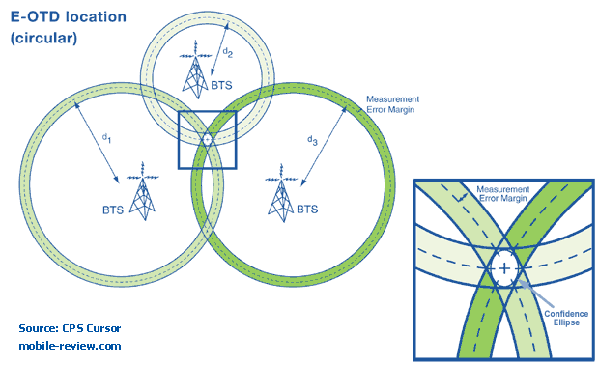
BTS - base station, d— geometric distance from a mobile phone to a base station ( s )
In E-OTD, the time of simultaneous passage of a signal from a base station to a device, as well as to another base station, is measured. For accurate calculation of coordinates, you need at least three base stations, then the phone’s position is triangulated .
Since the method requires special software on the phone, the E-OTD positioning system was used less widely than the U-TDOA system.
Time difference

( c )
In radar, hyperbolic positioning is the process of determining the position based on the difference in reception time ( Time Difference of Arrival, TDOA ) of a signal emitted by an object in the direction of three or more receivers. The method involves measuring the time between sending a signal to a base station and receiving a response without using the equipment of a telecom operator - the phone "observes" the difference in the time of receipt of signals from different base stations. This data is called "observed time difference (OTD)".
U-TDOA - Uplink-Time Difference of Arrival - determines the location depending on the time it takes for a signal from a mobile phone to pass to each of the sensitive receivers, called Location Measurement Units (LMU). Using information from several LMUs, U-TDOA calculates the location of the mobile phone using the same multilateration method.
Since U-TDOA is a network location technology, it does not require a special chip or additional software to be built into the phone. As a result, U-TDOA can be used for any phone. The disadvantage of this solution is that only the owner of the base stations has access to the technology.
The method allows to achieve positioning accuracy in the range from 50 to 100 meters, which exceeds the capabilities of E-OTD and is almost comparable to AGPS.
U-TDOA allows you to find with very high accuracy even those phones that do not support GPS. The location detection method cannot be disabled by the telephone user (only if the phone itself is turned off) and works both indoors and outdoors. Theoretically, to hide your real location and at the same time to remain a user of the system is possible only with the help of a method based on the technology of obfuscation of coordinates (from the English obfuscate - to make it unclear, confusing, to confuse). The technology allows artificially inserting into the measurement data some fake points.
Independent determination of the coordinates today is of sports interest only - for those who want to learn more about the capabilities of modern cellular networks. For everyone else, this is just another convenient commercial service that has long ceased to amaze.
Source: https://habr.com/ru/post/358538/
All Articles