News from the world of OpenStreetMap №392 (01.16.2018-22.01.2018)
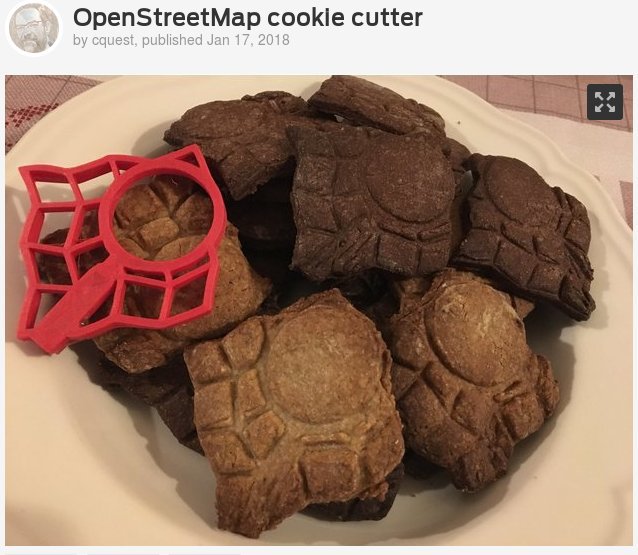
Mold for cookies from Christian Quest [1]
Cards
- The GIScience research team from the University of Heidelberg announces a new version of OSMlanduse.org . The gaps in OSM data (for Germany only) are now filled with data extracted from satellite images obtained using machine learning methods.
- TravelTime provides two interesting maps based on various sources on OSM data: RadiusMap , which compares a simple “reach radius” around a point with travel time (isochron) and a travel-only time map that includes walking, cycling, car and public transport.
Mapping
- The Open Data Institute Cardiff announced a beta version of the Wales map with Welsh names based on OpenStreetMap data. It combines two other Celtic languages, Breton and Irish , which already have OSM-based maps. Carl Morris (Carl Morris) describes his approach to rendering. There are many objects in OSM that list Welsh names.
- Now that OsmAnd has begun to display deserts, the Warin participant has begun a discussion on the talk-au mailing list on how to map them. The discussion mentions the climatic definition of the desert and the difficulty in displaying the fuzzy boundaries of such areas.
- Daniel wrote about how to connect highway junction nodes - as a rule, those points that connect a motorway and a junction motorway_link are needed to improve routing. Discussions in the comments.
- Reddit user Toxx8 asked for help in subdables / r / openstreetmap in importing the official dataset from Queensland, Australia, and resolving licensing issues. The discussion continues on the talk-au mailing list.
- On the Mappa Mercia blog, they wrote a record about the import, which led to erroneous data in the location of the gas stations on the OpenStreetMap map, they found some of them and added a “fixme” tag. This will help anyone identify and correct these errors.
- Francois Lacombe (François Lacombe) notes that the process of voting for the proposal for tagging hydropower facilities has begun.
- Brian Prangle of the Mappa Mercia team wrote an article about the future of phone booths in the UK.
Plans include dismantling half of the telephones and then reinstalling in other places. Brian anticipates future problems with checking phones on the ground and on the map, and also reports that British Telecom is unwilling to share its data with OSM.
Community
- [1] Christian Quest combines several hobbies : baking cookies and OSM. As a result, he got a cookie with the logo of the OSM. You can download the STL form file .
- Jan Kinne and Bernd Rensch from the Center for European Economic Research analyzed samples of software companies at the microgeographic level, using data from OpenStreetMap in Germany ( PDF document ). The main factor limiting the accuracy of the study is the lack of point (not generalized) geospatial data on socio-economic demography.
OpenStreetMap Foundation
- In addition to the first meeting of the OSM Board in 2018, an additional meeting was held on January 25th.
- OSMF published the minutes from a recent meeting of the OSM Foundation Board, Christoph Hormann aka imagico shared ( auto-translation ) on the blog his view of this meeting and this caused a lot of reactions from board members.
- The minutes of meetings of the Working Group on Communications (CWG) from 12.19.2017 and 16.01.2018 are published, and the protocols of the Working Group on Data (DWG) from 11.01.2018 are also available.
- OSM-US is looking for candidates for the upcoming elections to the local board of the fund.
The article also sets out goals for 2018: hire an executive director, become the official local representative of OSMF, and redesign the website.
Developments
- There is still time to apply for scholarships to attend the State of the Map 2018 conference in Milan, Italy. The deadline is February 14th. Read helpful tips for applicants and increase your chances of getting financial support for this program.
Humanitarian OSM
- About the eruption of the volcano Mayon in the Philippines wrote in the mailing list HOT. Links to the task list for mapping can be found in discussions .
- And in 2018 there are two promotional programs from HOT for the OSM community.
- With the help of the non-governmental organization Nethope, HOT acquired computers and mobile phones in different countries and finances mapping courses. Details can be found on the HOT site .
Licenses
- The famous city in Bosnia and Herzegovina claims that it has every right to its name.
Software
- Fred Moine announced the completion of the translation of the QGIS textbook into French.
- The sidebar has been reworked on MapCat.com, and now it displays additional information (opening hours, Wikidata).
- Sarah Hoffmann explains
Changes in the processing of zip codes of regions and tags in the Nominatim geocoder. - Daily 5.25 million routes are calculated using the Matrix API in the OpenRouteService service created and maintained by the University of Heidelberg.
- The Zhuangfang member from the Development Seed team wrote an article on how to create a building classifier in Vietnam to detect them. In this example, Label Maker will extract raster samples from Mapbox Satellite imagery and vector data from OpenStreetMap. On this basis, they will prepare training data that will be used for MXNet training in Amazon SageMaker, Amazon Web Services (AWS) service, which allows users to develop, train, deploy machine learning services.
Programs
- Published version 2.6.0 of the iD web editor (Changelog).
The main new feature is the ability to adjust the brightness, contrast and sharpness for satellite images. Now iD also prohibits the user from drawing overlapping lines. - The delivery of Mapbox Navigation SDK for iOS v0.12.0 includes updated installation instructions for Carthage, a route termination response interface, improved hints in roundabout locations, improved road name pronunciation , fast / slow route simulation, Bulgarian localization ( translations other languages are welcome ), and much more.
- The component MapboxDirections.swift v0.16.0 improves compatibility with Objective-C, despite the name.
Programming
- The WeRobotics team launched a machine learning competition ,
the purpose of which is to identify roads, coconut palms, banana trees, papaya and mango trees in aerial photographs; the prize is nothing but fame and notoriety. ( details ) - Heidelberg Institute of Geo-Information Technologies is looking for a developer backend (Java or C ++). The contract is limited to two years.
- Jan Marsch has published a SQL function for calculating shadow rendering in Postgis, the code can be deleted on Github .
- Paul Norman (Paul Norman) instructs how to make a shell script to load the OSM plan dump and retrieve the desired area with reliable error handling.
- Robin Boldt, the developer of the Kurviger.de website, wrote an article
for the Graphhopper blog, about the transition from Mapzen services to alternative services, and about what tasks the developers face when creating vector tiles. - HeiGIT has developed a new service, “ OSM data download in real time ” (source code is open). This will automate the creation of uploads with the most current OSM data, in pbf format, for arbitrary areas needed by users. For example, they are needed during times of disasters for the most frequent updating of maps and services, such as the Crisis Center - Route Building Service.
Do you know ...
- ... about the site WhatWhere (WhatIsWhere) to search for POI (points of interest)?
Other "geo" events
- The blog North Road described the new features of QGIS 3.0.
- The cartographic platform CARTO announced its transition to Mapbox to provide fast visualization of large amounts of geodata, accurate geocoding and improved routing.
- Interview published on Spiegel Online
 with Heinz Vielkind, who draws the schemes of the ski slopes, he has to choose between the display of real paths and the usability of the scheme.
I apologize for any typos, broken links or absurdities.
If you notice a problem - please write in a personal, be sure to fix it.
News last week .
')
Source: https://habr.com/ru/post/348002/
All Articles