Features of industrial aerial photography. Part I. Preparatory rake
 If we ignore the use of unmanned aerial vehicles (UAVs) for weddings, celebrations and anniversaries, it becomes obvious that a powerful tool has appeared in the arsenal of territory mapping, environmentalists and the military — industrial unmanned aerial vehicles that are capable of solving various tasks of building high-quality cartographic information, detailed orthophoto plans of territories, forests, agricultural lands and urban areas. Taking into account the fact that getting a high-quality photographic material for building 3D terrain models only at first glance seems simple, in reality, the task has a lot of all sorts of features. I wanted to share my own experience of organizing industrial aerial photography, the location of the rake, which had to be stepped on, or rather, which had to be flown. For all the details I ask under the cat.
The choice of drone
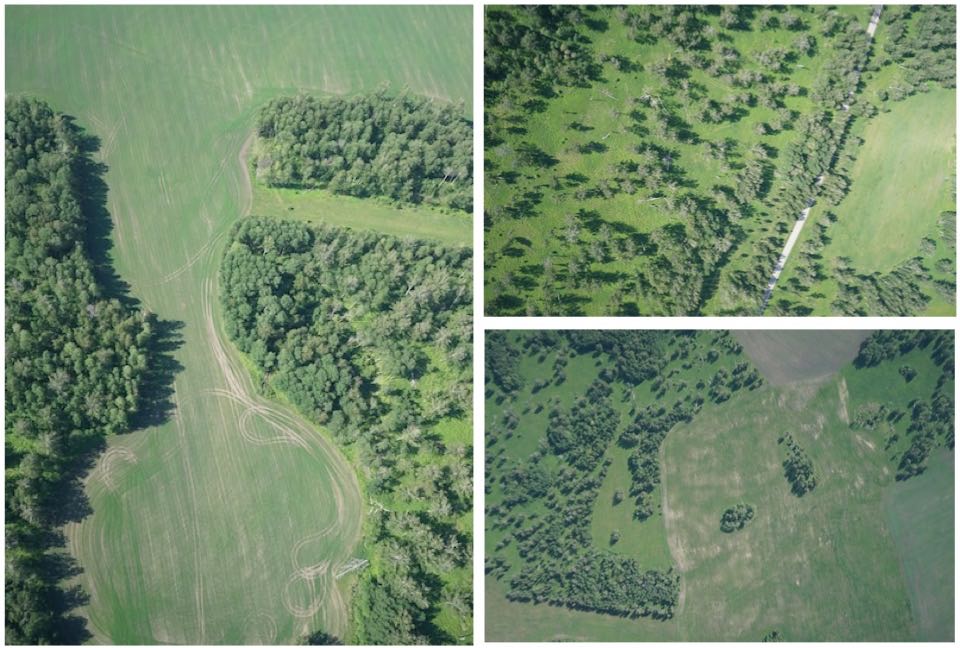
To begin with, we will define the task that had to be solved in this work. The first task is to build a 3D model (orthophotomap) of a fairly large area of agricultural land of one of the customers, whose fields are essentially surrounded by forests, or as we joked later - fields that are found in the forest. This is a typical situation for agriculture in the Tomsk region, which is extremely forested. Yes, see for yourself - everything will become clear without words.
')
A large territory and completely outdated data on land allotments do not provide an objective assessment of the state of the land, so it becomes not only interesting for the owners of land, but it is also advantageous to understand what resources they own (or do not own) in reality.
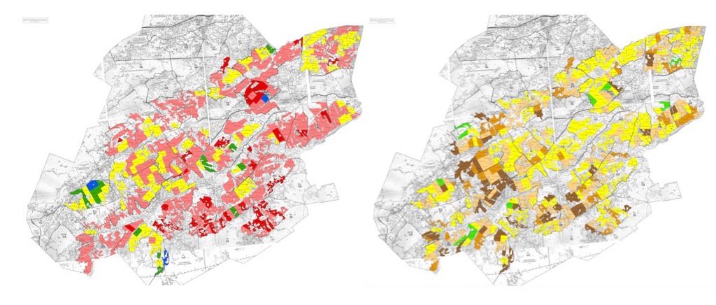
Owners of the land have access to such antediluvian tablet cards, glued from paper with data on land allocation 30-40 years ago. Color data is even marked on the content of nutrients in the earth, which is the most important information for an agronomist, which in most cases is no longer true. In short, the century at least XXI, in fact, live data and maps of the middle of the last century. Of course, obtaining objective and updated information on the state of the land is useful not only for taking inventory of available land, but also for putting new land into circulation, for which you can get decent subsidies from the state. It remains only to find these lands among the swamps and forests. We begin the search.
For shooting such large areas, special industrial flight equipment is used - aircraft-type UAVs (“wing” type construction). These devices allow for 1 flight session to cover up to 1500 km 2 of the territory and to receive images with the necessary quality for further post-processing. The choice of UAVs on the market is quite large. Both imported and domestic UAVs on any pocket. True, dear ones and in my opinion are completely unjustified. But it can be seen as dictated by the market. Prices from 1 million for a decent machine. I suggest to stop a little and watch a short video (2 min 30 sec), which I specifically shot for Habr's readers for this article, to immediately understand what kind of industrial UAV it is and how it looks.
UAV shooting
The plane itself will not fly anywhere unless it is launched into flight and does not do what it has to do. And what exactly should a UAV do? He must strictly follow the flight instructions and take pictures in full compliance with the shooting plan, which is contained in the flight mission.
Flight mission
Flight task - a specialized instruction, consisting of instructions to operators for carrying out the shooting process, contains all the necessary requirements, including approval of the scale of photographing and focal length of photographic equipment, aerial photograph format, specified percentages of longitudinal and transverse overlaps, dimensions of the filming area. From these source data, determine the height and basis of the survey, the interval between exposures, the number of aerial photographs in the route and on the shooting area, as well as the estimated time required for aerial photography of the entire area. It is important not to forget that the pictures should be in strict accordance with the chosen shooting scale.
What is the scale of shooting?
On the scale of aerial photography, conditionally divided into super large-scale (larger than 1: 2000, resolution up to 20 cm), large-scale (from 1: 2000 to 1: 10,000), medium-scale (from 1: 10,000 to 1: 30,000), small-scale (from 1: 30,000 to 1: 100,000) and super small-scale (smaller than 1: 100,000). Hereinafter we are talking about the correspondence of the sizes of objects in reality, correlated to their image in a digital image for 1 pixel. That is, for example, in a 1: 2000 extra large-scale image, 1 pixel image corresponds to an object measuring 20 cm.
Overlapping terrain photography
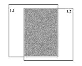
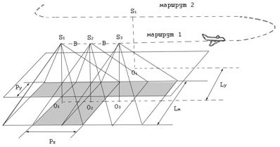
In order to obtain high-quality cartographic information and build a 3D terrain model, it is necessary to conduct a survey of the territory with overlapping, i.e. to take a piece of land as often as possible so that the next picture “overlaps” the previous one, by analogy with the roof of the roof, where each tile covers a part of the previous one. That is, shooting from a UAV is carried out as shown in the figure - with overlapping.
And the whole territory should be divided into routes, i.e. we get the n-number of images along and across, respectively, with longitudinal and transverse overlap, as shown in the following figure
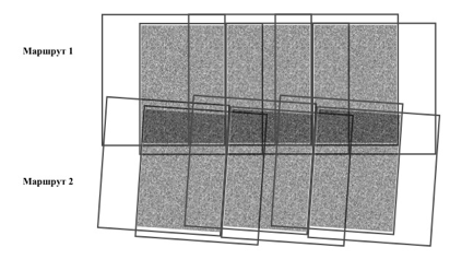
The size of the longitudinal overlap between adjacent aerial photographs of one route is usually within 55-70%, and the transverse - at least 20%.
Overlaps have features. Rake number one
The overlaps between adjacent images of the same route, which are called longitudinal (Px), have their own specifics. Too small and too large overlaps of images for the tasks of constructing 3D models of the territory are not suitable. To obtain a stereoscopic (three-dimensional) image in theory, it is sufficient to have a longitudinal overlap of 50%. However, due to edge effects and aberrations (image distortion) of images, the longitudinal overlap somewhat increases. Large overlaps are also unacceptable, as this dramatically reduces the volume of the image, and, as a result, deteriorates the quality of the construction of 3D models. With almost 100% overlap, two identical pictures are obtained that have no stereoscopic effect and this is not valid. The overlaps between adjacent images in the flat shooting conditions should be within 55-70%, in mountain conditions and if there are significant differences in the terrain, the overlap can be significantly increased up to 80-90% without losing the quality of 3D terrain model construction.
This type of shooting, which is used in most cases, refers to areal shooting with overlapping.
Before starting work, they check all the necessary equipment, materials and flight maps, conduct crew training and schedule flights (shooting routes) in accordance with the flight tasks, then check all the necessary calculations of shooting parameters.

The table contains all the necessary input data for aerial photography and the calculation of all its parameters. Of course, the input of this data goes automatically, but I will give the calculation formulas in order to have a general idea, which is always useful.
To obtain the necessary resolution of images, shooting with a UAV must be conducted at a strictly defined flight altitude H floor .
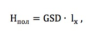
where H floor - flight altitude, m; GSD - pixel resolution, m / px; l x - the size of the matrix of the camera (on the x -axis), px.
The distance between adjacent images (B) for the subsequent calculation of their number along a longitudinal route is defined as
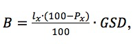
where P x - longitudinal overlap,%; GSD - pixel size on the ground.
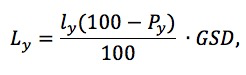
The width of the route on the ground (L M ) depends on the size of the matrix (in the direction of the ordinates) (l y ) used in combination with the UAV of a digital camera and is determined by the following relationship:
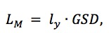
where l y - the width of the matrix along the axis "y", px.
Determine the distance between adjacent routes L y shooting with the condition of lateral overlap P y can be calculated by the formula
Next, you need to calculate the number of shots in the route N sn , which is defined as the ratio of the length of the section to the distance between the shots taking into account the longitudinal overlap
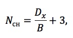
where the length of the section D x is equal to the length of the average route in the longitudinal direction from the left edge of the first aerial photograph to the right edge of the last aerial photograph with a margin of 1 photograph.
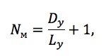
The number of routes N m is calculated taking into account the width of the section D y , which is measured in the transverse direction in the middle of the upper side of the first route image to the lower side of the last route image with a margin of 1 route.
The total number of shots per area N of the study area is defined as the total number of shots for all survey routes, and the minimum flight time of the survey, which, in particular, can be used for relevant economic calculations of the costs of the work, is calculated by the formula:

where V is the average speed of the UAV in the process of shooting the territory.
Of course, this is the estimated shooting time and it has nothing to do with the time of the real work, which, depending on the number of scattered rakes for which you have to walk, may differ by a couple of orders from the calculated one, but still)
As mentioned above, all the above-mentioned shooting parameters are set automatically based on the use of modern UAV equipment, equipped with specialized controllers and modern software. However, while ensuring the internal control of work, it is necessary to control the accuracy of the input of the initial data, and the resulting images should be selectively (or entirely) checked for quality. For this, it is necessary to maintain (in paper or digital form) flawed maps of the surveys carried out (pictures are evaluated on a 5-point scale). The detection is carried out on the spot, in order to retake unsuccessful sections, if necessary, in order not to repeat the trip again.

And a little about the weather. Another rake
The shooting of the earth's surface is carried out through the thickness of the atmosphere, the characteristics of which are not constant. The state of the atmosphere determines the conditions and results of shooting. The physical state of the atmosphere is characterized by its transparency and refraction of rays in it, air temperature, atmospheric pressure, air humidity, cloudiness, movement of air masses. The greatest influence on the effectiveness of shooting in the visible and near-IR spectral ranges have the degree of transparency of the atmosphere, light and clouds.
In the layer of the atmosphere between the earth's surface and the imaging system mounted on the UAV, there are always to varying degrees the smallest (0.01-1 mm) particles of gases, water vapor, dust, smoke. They cause the scattering of light in the atmosphere and cause additional brightness of the air itself, thereby reducing the contrast of parts of the earth's surface. The glow or turbidity of the atmosphere due to the scattering of light from particles suspended in the air is called haze. With the prevalence in the atmosphere of molecules of gases and water vapor, rays with a short wavelength are scattered more strongly and the atmospheric haze has a predominantly blue or blue color. If suspended particles of dust, smoke and other extraneous bodies prevail, the rays of all the colors of the spectrum equally dissipate in a haze and it itself takes on a gray or whitish color. This haze is more common in areas with smoke from forest fires and industrial plants or in areas where dust and sand particles are spread.
Aerial surveys are usually performed on bright, sunny, cloudless days. Cirrus and cirrus clouds do not prevent them. When shooting, you should choose the direction of west-east . This requirement is due, in particular, to the exclusion of the parasitic influence of sunlight.
Aerial photography is also possible with high continuous clouds, located above the UAV that performs the survey. High continuous cloudiness allows to obtain shadowless aerial photographs with softened tones of shadows, as a result of which the forest canopy can be viewed more deeply, its shaded parts are better visible.
For the purpose of deciphering forest vegetation, the influence of the height of the Sun at the time of the survey is important: the higher it is, the more contrasting the ratio between the lit and shaded crowns in the canopy of the stands. Shadows are also more clearly cast.

With the height of the Sun more than 30 °, the general view of the canopy canopy is bright and variegated, since closed plantings consist of light crowns and a dark background from the shaded intervals between the crowns.
Usually, shooting begins no earlier than 2 hours after sunrise and ends 3 hours before sunset. In most cases, aerial photography time is limited to three to four hours, because after 9-10 hours, especially in forest areas, cumulus cloudiness appears, reaching its greatest development by 13-15 hours. Not a dogma, observation from own experience.
The direct limitation of filming is the presence of heavy rain, snow, thunderstorms, or sudden gusts of wind with a horizontal speed of more than 10-15 m / s and vertical gusts of more than 3 m / s. However, in spite of the fact that modern industrial UAVs can be operated under conditions of significant wind load, it is advisable to have meteorological monitoring systems for flight conditions, which should be accompanied by control of horizontal and vertical wind speed and air humidity, since humidity significantly affects air density and as a result, on the aerodynamic properties of the UAV. Despite the fact that manufacturers of UAVs write in advertising that their devices fly in virtually any weather - it is better to carry out flight activities in normal weather. Losing a UAV is much more expensive than waiting for suitable weather conditions. After all, most of these devices are dying for two reasons - razdolbaystvo operators and inappropriate weather. That and the other is for manufacturers of UAVs a "golden bottom", because expensive UAV repairs are also sooooo profitable business. Therefore, it is impossible to save on the training of operators and rush events with the desire to do everything quickly. This is exactly the case when haste and laughter are in the most direct relationship.
Careful, harsh laws!
Imagine that you have excellent equipment, industrial UAVs and excellent operators, customers of the work, but you still went to prison. Yes, exactly, because non-compliance with the requirements of the legislation for the organization of flight operations and the opening of the airspace can quite easily lead to such consequences. Nothing can be done about it, in this sense everything is invented in Russia so that even if all the rules are followed, something can be ignored. In general, the process of obtaining official permission to fly (the opening of airspace) is still that concert. Each case is specific. The general principles are as follows. For the implementation of flight operations using a UAV, it is necessary to strictly follow the requirements of the law. The main document for work on the opening of the airspace is the Decree of the Government of the Russian Federation of March 11, 2010 N 138 “On approval of the Federal rules for the use of the airspace of the Russian Federation”. The second paragraph of the Rules contains the definition of a UAV: an unmanned aerial vehicle — an aircraft that performs a flight without a pilot (crew) on board and is automatically controlled in flight by an operator from a control point or a combination of these methods.
Thus, in order to fulfill the requirements of the Legislation to ensure flight operations (in general), it is necessary to perform a number of mandatory measures. It is necessary to prepare the Report on the flight plan of the unmanned aerial vehicle (hereinafter referred to as the report on the launch plan). A message is information about a planned airspace use activity that is sent by the airspace user or his representative to the air traffic services (flight control) body via the aeronautical terrestrial data network and telegraph messages, via the Internet or on paper, including facsimile .
The launch plan report on the aeronautical terrestrial data network and telegraph messages, as well as on paper, including a facsimile message, is sent in the form of a formalized telegram consisting of three parts: an address, information, and subscription.
The address and subscription parts of the telegram are filled in accordance with the established rules for addressing and transmitting telegraph messages.
The information part of the telegram is filled in sequence and according to the rules defined by the Table of messages on the movement of aircraft in the Russian Federation and the requirement of the Legislation.
The launch plan report via the Internet is sent by filling out the information part of the aircraft’s flight plan on the website of the ATS unit in the sequence and according to the rules defined by this Report.
The text of the launch plan message is written in block letters in the appropriate cases of the Latin or Russian alphabet. In view of the dynamically developing legislation on the use of airspace, these rules change. Failure or partial implementation of these rules may lead to the administrative responsibility of individuals or legal entities, and in the case of serious consequences - to criminal liability in accordance with the procedure established in the Legislation.
Requirements for UAV operators and flight managers
Modern professional UAVs are a means of increased danger. The presence of the main engines, the significant weight of the UAV and the complexity of operation impose certain requirements on the qualifications of the operators. Shooting forested territory in the Siberian region is associated with the danger of falling into the zone of action of forest fires, an additional danger factor is the presence of mites and nasal delusions. Personnel must strictly comply with the requirements of the operator’s safety instructions, work will be performed by at least two operators. People performing field flight operations should be vaccinated against tick-borne encephalitis, have special protective clothing, a UAV operator certificate and a civilian passport, a set of permits for opening airspace, first-aid kit and communications equipment.In the absence or unstable areas of cellular communications, there are VHF and HF radio stations. When organizing filming with a UAV in places where dangerous animals appear, the flight supervisor must have the means to scare them away (noise cartridges and special equipment) or firearms (if licensed). If it is necessary to use a weapon, this fact is reported to the law enforcement agencies and (or) forestry specialists to activate the case.
If any hazardous phenomena appear in the flight area, they should be immediately stopped, and the flight director should make all reasonable efforts to ensure the safety of operators and immediately leave the dangerous place, for example, as the focus of a forest fire approaches.
Well, something like this is the preparation for carrying out UAV shooting using industrial flight equipment. In the subsequent series (articles) we will consider the technologies of processing and interpretation of the images obtained by the UAV in order to obtain high-quality cartographic information and 3D terrain models. We will also talk about the decryption of various interesting objects in pictures with UAVs. It will be more interesting! Have a nice day!
Source: https://habr.com/ru/post/347344/
All Articles