News from the world of OpenStreetMap №390 (01/02/2018-02.01.2018)
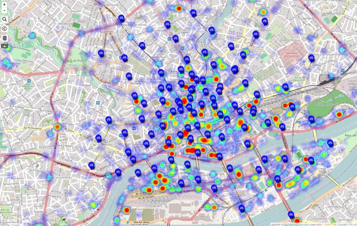
Heat density map of bicycle parking spaces in Nantes, France | OpenStreetMap Participants , CC-BY-SA 2.0
OpenStreetMap Foundation
- The German-speaking association FOSSGIS eV has now become the official regional office of the OSM Foundation! FOSSGIS eV was founded in 2001 and initially focused on supporting the development of free open source software for mapping purposes. They have been supporting the German OpenStreetMap community since 2008.
- OSM US began a search for a full-time executive director, Michal Migurski has already announced that he is interested in joining the work of the hiring committee.
- Some services managed by the OSM Foundation are translated to HTTPS and therefore may not be accessible via HTTP. When this happens, some software may stop working because of this (for example, after redirect requests from http to https). Work is underway to minimize such cases.
Mapping
- Fernando Trebien (Fernando Trebien) writes to the mailing list by tagging, asking about how to add participants to all types of relationship routes.
- Mateusz Konieczny asks a question about the units for the
seamark:light:rangetag for beacons. Values are always in nautical miles. However, this was not specified as the default unit . During the discussion, the articles added to the wiki. - Spanholz user posted short videos on Reddit explaining how to work in the iD editor and quickly start editing the OpenStreetMap map. Videos are licensed CC0.
Community
- Azavea engineers used the GeoPySpark package to create a multi-center isochronous map of the Isle of Man for pedestrians based on OpenStreetMap data.
- The Dzertanoj member wonders whether the fragmentation of communication channels does not interfere with each other, both within and between the OSM communities.
- Antoine Riche wrote a detailed tutorial on the Carto'Cité wiki about using Overpass queries and displaying results with uMap. For example, he chose to create a thermal map of the density of bicycle parking in the city of Nantes, France.
Imports
- Several cartographers report that importing data created by Facebook “AI” in Thailand made OSM unsuitable for use in some rural areas and wondered if it should be rolled back.
Developments
- Frederik Ramm invites the OSM community at the weekend to the hackathon in Karlsruhe, Germany.
- Call for papers for the State of the Map 2018 conference ( State of the Map 2018) in Milan is open! The form for registration of reports is available at this link . The deadline for submitting applications for the report is Sunday, February 18, 2018. If your company wants to be a sponsor, then read this information and write a letter .
Cards
- Hans Hack has published a map that allows you to discover places in Germany that are far from roads.
- In recent weeks, the newly launched Climate Protection Map , based on user data from OpenStreetMap, has been expanded worldwide. Now there are some additional layers on it.
switch2OSM
- Journocode, a German website dedicated to “bridging the gap between journalism and data science,” published a guide to extracting data from OSM using osmfilter (and osmconvert).
Software
- NZZ has released a demo of its web Q story telling tool, which can be used to create different maps on top of Mapbox maps.
Programming
- On iOS and MacOS, there are far fewer non-commercial programs than Android, because the higher costs associated with Apple frighten developers. However, it is now possible for non-profit organizations (including educational institutions and US government agencies) to ask Apple not to levy an Apple Developer Program fee. This applies only to developers of free applications and will solve only part of the problem (although not completely, because you still have to buy a Mac device and / or iPhone).
Programs
- There is a new stable release JOSM, find out what's new in it!
Do you know …
- ... about MAPCAT.com ? It shows the map using vector tiles, so you can choose in which languages the names are displayed. Based on OpenStreetMap data.
- ... about the Android application BumpRecorder ? The application recognizes potholes and can display their location on the OSM map. The data should help road services recognize the potholes before they become large.
Other “geo” events
- There is a free source from which you can download historical aerial photographs, thematic maps and the results of the Antarctic expedition.
- German magazine Spiegel Online reports (automatic translation ) that fake geospatial information has always been the place to be, and this was due not only to military reasons.
- The message in the MapPorn subtitle contains a fascinating map that shows the borders of the countries and the date of their appearance. The discussion begins with details about the complex research for this map and continues with often surprising facts about boundaries.
- According to the golem.de website, the HERE map data provider has another owner ( automatic translation ). Bosch and Continental joined Daimler, BMW and Audi. Automakers are investing in HERE, so as not to depend on other data providers, such as Google or Apple. HERE will create highly accurate digital maps for use in autonomous cars.
- The Guardian newspaper writes about why autonomous car developers believe that chaotic traffic conditions make Moscow an excellent testing ground.
- Ellie Craven wrote an article on why unique identifiers are rarely unique.
If you follow the life of the Russian community OpenStreetMap and are ready to join with the compilation of weekly news, then write to me.
')
Source: https://habr.com/ru/post/346714/
All Articles