News from the world of OpenStreetMap № 389 (26.12.2017-01.01.2018)
Translation WeeklyOSM 389 .
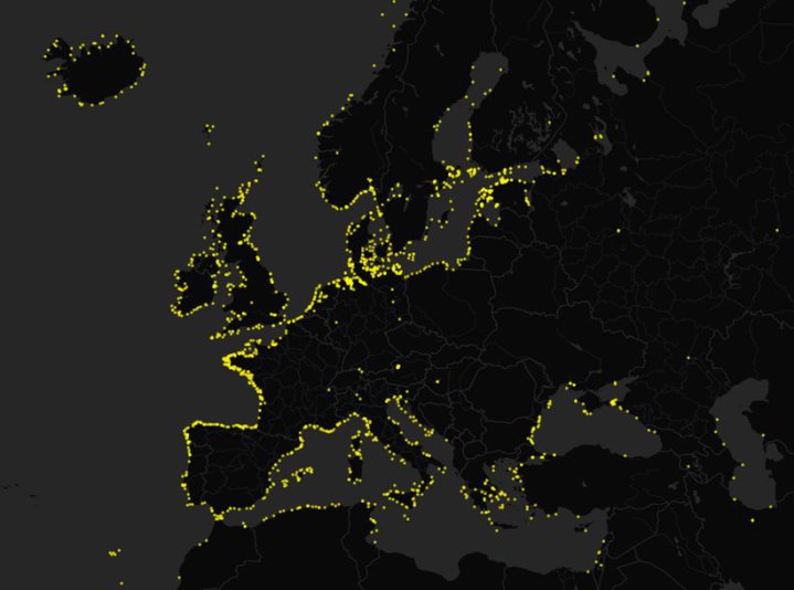
Europe Lighthouses (OpenStreetMap data) | OpenStreetMap members map_creator
About Us
- We join the congratulations of the OSMF Foundation , wishing everyone a happy New 2018! Your feedback and comments on the issues of the YESTERNIK Issue OSM is an important source of motivation for members of our entire team. We also welcome bjoern_m and Tordanik as new team members. Of course, as always, we are still looking for interested people who want to participate.
Mapping
- Bryan Housel asks for feedback on whether self-intersecting lines should generate an error in the iD editor. You can comment on the problem on github.
- Volker Schmidt (Volker Schmidt) asks why the emergency pockets on the roads are tagged differently than the bus pockets, although they are physically very similar.
- On the German forum there are people who disagree with whether to indicate addresses at the entrance or on the building scheme, but various possibilities are mentioned in the lively discussion (automatic translation ).
Community
- Daniel Koć asks in the mailing list how to find new members to work on the style of the OSM-carto card. Already have a list of problems that awaits new artists.
- The SomeoneElse member step by step described everything related to the creation of a successful pull request in OSM-Carto style.
- Already the “ Sixth Conference of the State Map (State of the Map) of France” will take place in Bordeaux , from the 1st to the 3rd of June, 2018.
- Researchers from the University of Minnesota investigated (pdf) mapping types for users of OpenStreetMap. They claim that interest in geography and mapping is genetic inherent (“innate, not acquired”).
- James Derrick reflects on how mapping, software and technology have changed in 10 years, in which he draws an OpenStreetMap map.
- Just Shuppe (Joost Schouppe) conducted an analysis of notes OSM Notes. In addition, he writes about the effect of Maps.me.
- On Reddite, the participant “map_creator” shared a map of the beacons listed in OpenStreetMap in Europe. The comments discuss which beacons are not yet marked and who can be contacted.
OpenStreetMap Foundation
- OSMF is very pleased to transfer bitcoins in the form of donations equivalent to £ 27,000 , and very much welcome this way of donations.
- The OpenStreetMap Foundation (OSMF) welcomes OpenStreetMap France, the official local branch of the OpenStreetMap Foundation.
Humanitarian OSM
- In the OSM diary, Tasauf writes about the contribution and impact of the BHOOT (Bangladesh Humanitarian Group OpenStreetMap Operations Team) on the OSM map and various initiatives in the area of disaster maps and on the humanitarian crisis in Asia, including Bangladesh.
Software
- Michael Spreng announced
 about starting the OSRM server at routing.openstreetmap.de , three routing profiles are available: for cyclists, pedestrians and cars. The server is funded by FOSSGIS, the German local branch of OSM Foundation. Michael stresses that this routing (routing) service is managed by the community, and is designed for commercial gain.
 - A marcusyoung member, on his Github page, presented a guide to OpenTripPlanner, describing how to use isochrones .
Programming
- Mapzen will cease operations at the end of January 2018. The migration guide lists all projects that will continue to exist. According to the tweet and project description, Valhalla developers are now working in Mapbox (Mapbox already has a routing mechanism - OSRM).
- Stefan Keller in the talks-ch mailing list presented a tool designed to make it easier for business owners to enter their data into OSM and keep them up-to-date. Write him your feedback.
- Thanks to the Google Impact Challenge ( GIC ) program in Germany, ( internationally ) published a Google offer to reward programmers with $ 20,000, $ 250,000, or $ 500,000 awards, which will write ( translate ) something useful for OpenStreetMap. The deadline for submitting applications is January 10, 2018.
- OpenStreetMap plans to apply again as a mentoring organization in 2018 for Google Summer of Code.
Do you know …
- ... that Belgium and the Netherlands ratified the change of their borders in order to rejoin the Maas Maas (Meuse) river, which was straightened back in 1961. It goes without saying that OSM has already been updated. The Netherlands received 13.28 ha. However, both countries will benefit, as land maintenance is simplified.
- ... about the 9th German OpenStreetMap conference and the 13th FOSSGIS conference in Bonn to be held in March 2018? especially about the OSM discussion thread on Saturday?
Other “geo” events
- The GEOBIA '18 Conference will be held in Montpellier from 18 to 22 June. It is designed to promote research and the development of global earth problems around the world with a special focus on the integration of big data and open source solutions and the support of selected young researchers.
- The first open source satellites are already in orbit in space! Their program code was developed ( Google Translate ) at 34C3 (the largest German hacker conference) in Leipzig.
- The Watson website announces the launch of a map of the Swiss Confederation , which shows all current deviations and delays in public transport in Switzerland. Data can be queried using this API . Particularly impressive is the quality of the data in 3D viewing.
- What would the London Overground map look like if it were designed as a map of the Berlin S-Bahn railway? Look at this diagram .
')
Source: https://habr.com/ru/post/346378/
All Articles