RusGIS - a platform for complex tasks with analytics and geodata
A huge number of popular systems today use geographic data - from the all-seeing Google to the amusing Tinder. You can implement some basic geofunctions using the API from well-known map providers. And if the service needs some special geodata? Combine and customize a bunch of spatial information in different layers? Link this with analytics? Or maybe you want to offer people your own geodata? Our new RusGIS platform is focused on such scenarios of increased complexity.
RusGIS collects, stores, processes, analyzes and visualizes spatial and other attribute data. And creates on their basis maps with analytical reports.
')
Main features and features of RusGIS:
RusGIS is implemented in a three-tier architecture:
As the main uses opensource software:
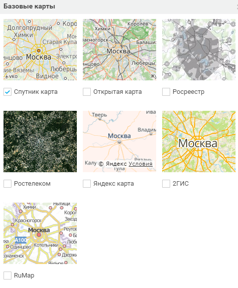
It all starts with choosing a base substrate. You can take your own base or connect external maps: Satellite, OSM, Rosreestr, Yandex, 2GIS, Rumap, mosaic of satellite images.
Work with layers is built flexibly, similar to Photoshop. Layers are freely turned on and off along with the legend, they are combined into any groups, their order and transparency is adjusted.
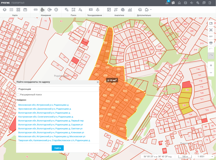
Any measurements on the map are available: distances along a broken line, areas along a freely constructed polygon, circle parameters, coordinates at a point. There is an attribute and spatial search, as well as geocoding - a quick transition to the desired site through the name of the territory from the list or coordinates.
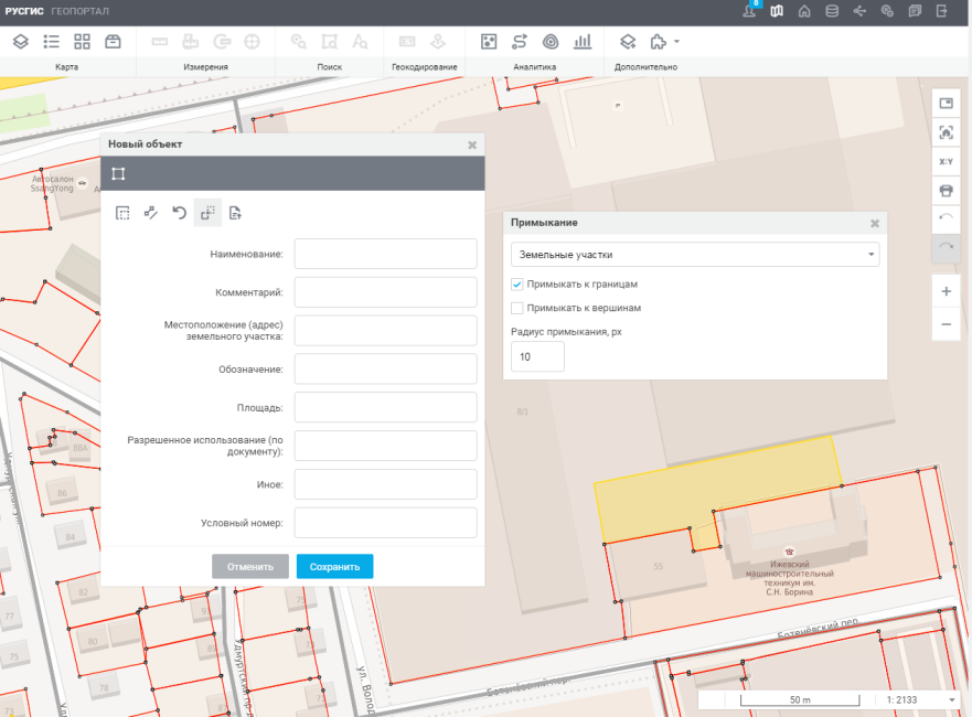
Supports the creation of objects with complex geometry, with the junction to the edges or nodes of objects.
RusGis is able to create layers according to the results of analytical processing - heat maps, diagrams, thematic coloring. They are displayed along with the data from the source.
Access to data and functions can be made public or flexibly configured by role. Appearance of the application, service and data models are customized through the administrator interface.
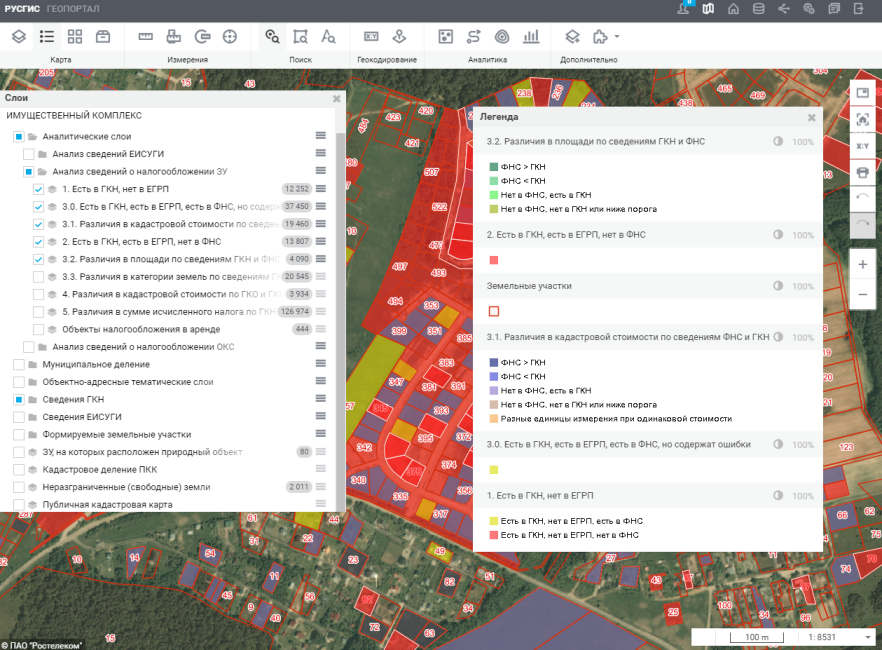
There is real estate in the bases of the Federal Tax Service, which is not properly accounted for. There are no real objects in these bases at all. And RusGIS can help eliminate these gaps and inaccuracies.
The system compares the databases of the Rosreestr, the Federal Tax Service, the local self-government, identifies discrepancies and builds beautiful reports - tablets, texts - and maps on which areas and ACS with different signs of violations are highlighted in different colors.
Additionally, orthophotoplans obtained from UAVs or airplanes are attracted here. By combining them with the data of the Federal Registration Service and local administrations, you can additionally identify vacant land plots, areas with signs of inappropriate use, areas with inconsistency of the actual borders of the documents.
With one layer we enter the existing road repair plan, with another layer - the status of the execution of the planned activities. When changing the status of the performance, the display of the road section on the map automatically changes.
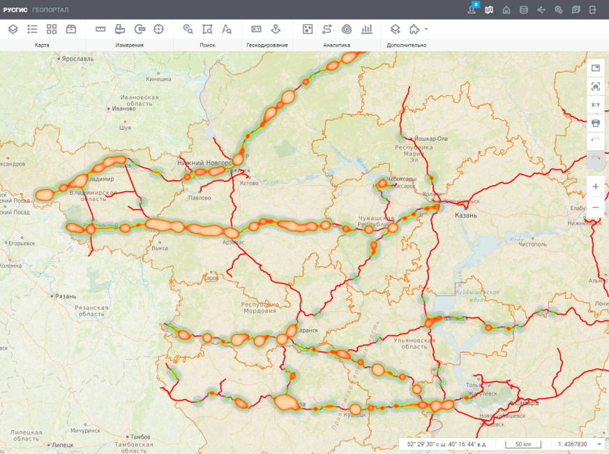
To reduce the number of injuries on the railway, you need to identify dangerous places on the basis of statistics and analyze the possible causes of accidents. Typically, the source data for analysis is a huge amount of text-based incident reports. Analyzing them manually is long and painful.
But from these texts with the help of parsing, you can extract data, and then put them on the map using symbols. As a substrate in the project, various basemaps are used. We overlay the incident map on the satellite imagery database and can immediately see the cause on the ground. For example, the lack of equipped crossings through railways in the area of urban development. To quickly assess the number of incidents in different places, heat maps are used, based on an analysis of the intensity of events.

For better perception of large data arrays, the clustering of symbols is used.
The project helps not only to identify problem areas, but also to quickly respond to new incidents. For this purpose, layers with prosecutor's offices and linear departments of the Ministry of Internal Affairs on transport were added to the map. When information about a new incident appears, the system determines the nearest transport prosecutor, a unit of the Ministry of Internal Affairs - it remains only to receive contact information. This solution is already used in the Volga Federal District.
The network map shows various types of lines and nodes. There is a viewing of statistics on incidents, availability and movement of spare parts in warehouses.

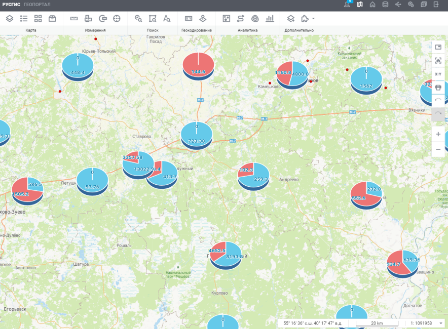
RusGIS is able to build cartodiagrams and compare different characteristics in them within one process. Thematic coloring, histograms, weight and pie charts allow you to assess the course of resettlement in individual localities. The map shows that there are localities where the program is executed, and there are those where it has not even been started yet. There are various intermediate stages.
In the RusGIS platform there is an API for integration with external systems. It implements the main functions: data visualization, model modification, data access control, etc. Of course there is documentation. API we provide on request.
Here is what we will do in the foreseeable future:
RusGIS is focused on B2B and B2G segments, so, unlike Yandex maps, Google and other well-known services, it does not have a free version. But the functionality of RusGIS is different, it is the decision of another segment. The platform is available in the Rostelecom cloud. It can also be installed on your own servers by purchasing a license.
If you are developing geoservices and supplying geodata or are interested in improving your software with their help, RusGIS may well be interesting. For questions related to the system, demo access and cooperation, please contact our grocery office “Geodata” at geo@rt.ru . We will also be happy to answer questions in the comments.
RusGIS collects, stores, processes, analyzes and visualizes spatial and other attribute data. And creates on their basis maps with analytical reports.
')
Main features and features of RusGIS:
- Creating a data model (domain description) via the web interface;
- Create new layers based on external files or existing layers using overlay, subtraction, copying, filtering, etc .;
- Editing data through a web interface, including spatial data on a map, taking into account the topology (junction, entry into borders, intersections);
- Import / export of spatial data in various formats via a web interface with drag-n-drop support;
- Batch forward / reverse geocoding based on external geocoders (Yandex / OSM) or own geocoder;
- Flexible integration at the level of data sets and REST / SOAP services;
- Flexible access control;
- API for embedding in third-party solutions, including the ability to manage the data model;
- Spatial analysis tools (accessibility zones, heat maps, etc.);
- Built-in analytical report designer;
- Mobile application for undoing data editing.
Solution Architecture
RusGIS is implemented in a three-tier architecture:
- level of information storage (DBMS servers and file storages),
- application server level (application business logic)
- level of client applications (user interaction with the system through the web).
As the main uses opensource software:
- PostgreSQL and PostGIS data storage;
- Geoserver for visualization of spatial data based on styles;
- Software for recognition of graphic information Tesseract and tools for generating reports and electronic documents Jasper Reports is running on servers that meet the specifications of the Java Enterprise Edition WildFly;
- Apache web servers.
- Apache LDAP server LDAP servers.
- Linux operating systems RedHat 6, Cent OS 6.8.
Custom tools
It all starts with choosing a base substrate. You can take your own base or connect external maps: Satellite, OSM, Rosreestr, Yandex, 2GIS, Rumap, mosaic of satellite images.
Work with layers is built flexibly, similar to Photoshop. Layers are freely turned on and off along with the legend, they are combined into any groups, their order and transparency is adjusted.
Any measurements on the map are available: distances along a broken line, areas along a freely constructed polygon, circle parameters, coordinates at a point. There is an attribute and spatial search, as well as geocoding - a quick transition to the desired site through the name of the territory from the list or coordinates.
Supports the creation of objects with complex geometry, with the junction to the edges or nodes of objects.
RusGis is able to create layers according to the results of analytical processing - heat maps, diagrams, thematic coloring. They are displayed along with the data from the source.
Access to data and functions can be made public or flexibly configured by role. Appearance of the application, service and data models are customized through the administrator interface.
Examples of using
Search for unaccounted tax items
There is real estate in the bases of the Federal Tax Service, which is not properly accounted for. There are no real objects in these bases at all. And RusGIS can help eliminate these gaps and inaccuracies.
The system compares the databases of the Rosreestr, the Federal Tax Service, the local self-government, identifies discrepancies and builds beautiful reports - tablets, texts - and maps on which areas and ACS with different signs of violations are highlighted in different colors.
Additionally, orthophotoplans obtained from UAVs or airplanes are attracted here. By combining them with the data of the Federal Registration Service and local administrations, you can additionally identify vacant land plots, areas with signs of inappropriate use, areas with inconsistency of the actual borders of the documents.
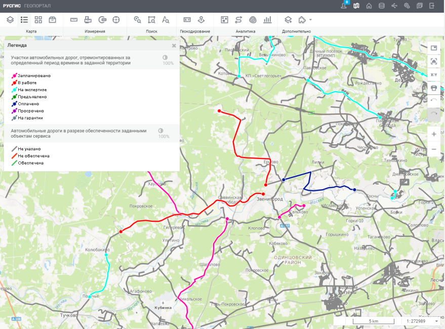
Road repair monitoring
With one layer we enter the existing road repair plan, with another layer - the status of the execution of the planned activities. When changing the status of the performance, the display of the road section on the map automatically changes.
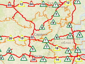
Improving railway safety
To reduce the number of injuries on the railway, you need to identify dangerous places on the basis of statistics and analyze the possible causes of accidents. Typically, the source data for analysis is a huge amount of text-based incident reports. Analyzing them manually is long and painful.
But from these texts with the help of parsing, you can extract data, and then put them on the map using symbols. As a substrate in the project, various basemaps are used. We overlay the incident map on the satellite imagery database and can immediately see the cause on the ground. For example, the lack of equipped crossings through railways in the area of urban development. To quickly assess the number of incidents in different places, heat maps are used, based on an analysis of the intensity of events.
For better perception of large data arrays, the clustering of symbols is used.
The project helps not only to identify problem areas, but also to quickly respond to new incidents. For this purpose, layers with prosecutor's offices and linear departments of the Ministry of Internal Affairs on transport were added to the map. When information about a new incident appears, the system determines the nearest transport prosecutor, a unit of the Ministry of Internal Affairs - it remains only to receive contact information. This solution is already used in the Volga Federal District.
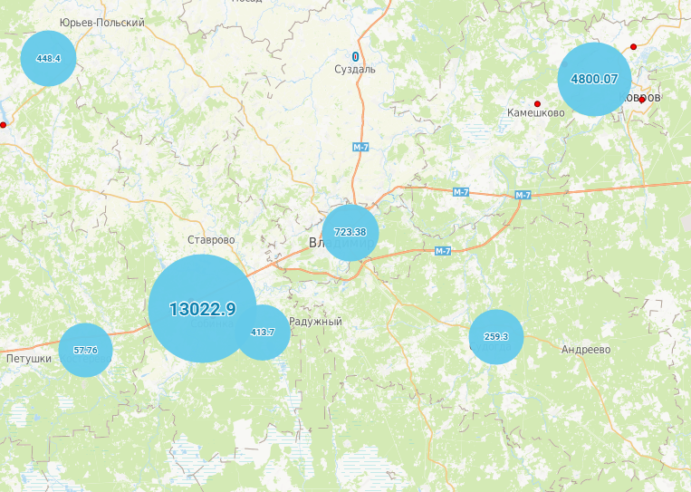
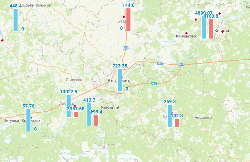
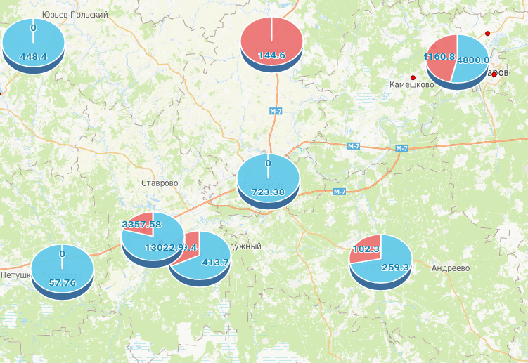
Monitoring of incidents in communication networks
The network map shows various types of lines and nodes. There is a viewing of statistics on incidents, availability and movement of spare parts in warehouses.
Control of relocation from dilapidated housing
RusGIS is able to build cartodiagrams and compare different characteristics in them within one process. Thematic coloring, histograms, weight and pie charts allow you to assess the course of resettlement in individual localities. The map shows that there are localities where the program is executed, and there are those where it has not even been started yet. There are various intermediate stages.
API
In the RusGIS platform there is an API for integration with external systems. It implements the main functions: data visualization, model modification, data access control, etc. Of course there is documentation. API we provide on request.
Our plans for the future
Here is what we will do in the foreseeable future:
- improve data analysis tools
- expand the number of partner providers of geodata and geo-services,
- offer new products and services at the junction of technologies: UAV, remote sensing, GIS, IoT, etc.
- develop network topology tools;
- create a convenient data mart and applications for users of the platform.
RusGIS is focused on B2B and B2G segments, so, unlike Yandex maps, Google and other well-known services, it does not have a free version. But the functionality of RusGIS is different, it is the decision of another segment. The platform is available in the Rostelecom cloud. It can also be installed on your own servers by purchasing a license.
If you are developing geoservices and supplying geodata or are interested in improving your software with their help, RusGIS may well be interesting. For questions related to the system, demo access and cooperation, please contact our grocery office “Geodata” at geo@rt.ru . We will also be happy to answer questions in the comments.
Source: https://habr.com/ru/post/343580/
All Articles