Toll Highway Technologies: Present and Near Future
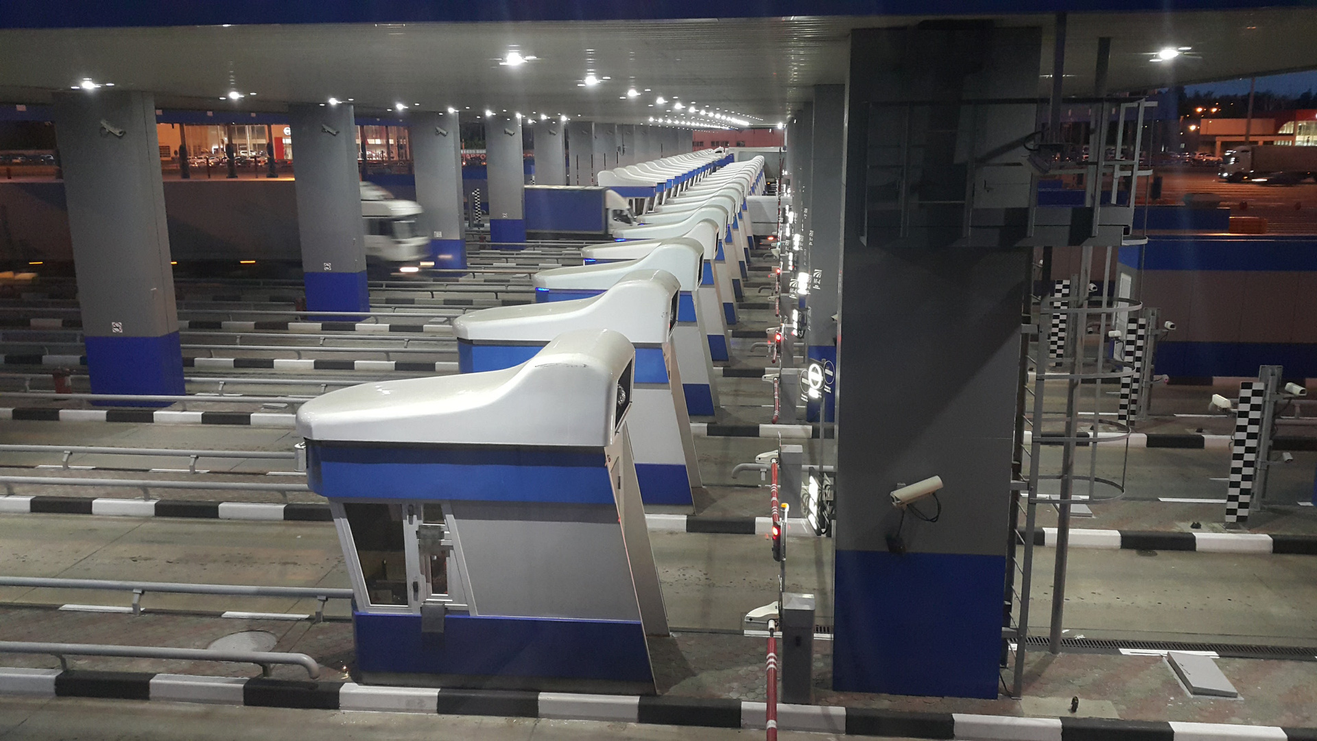
The “classic” toll collection point on the Voronezh bypass is one of the largest in Europe
More than two years have passed since the last article on toll roads technology was published. During this time, the network of toll roads in the Russian Federation has increased significantly, new technologies have emerged and have been applied, old problems have finally been resolved (and new ones have emerged). And also the mega-project “Plato” was launched, about the technological nuances of which you can release a whole series of articles (modestly keep silent about social nuances). Regardless of whether we like the idea of toll roads or not, their automation is a very interesting and specific IT task, located at the junction of various disciplines. There will be more and more projects in this area, and fewer people with a comprehensive understanding of the task. Therefore, in order to at least a little to correct the deplorable situation described, let's summarize what has already been done in the toll road industry in our country, and look a little further in order to navigate the technologies for which to rely in the next couple of years. Perhaps it is useful.
Have a nice trip, or a barrier in lobovuhu
')
The field of collecting money for travel according to the “classical” scheme with the vehicle stopping at the cabin (experts say in the payment zone ) has existed in our country since 2011. At the start, the automation of this business was entirely occupied by foreigners, but today we ourselves have learned something and even “imported” some components. The basic technological aspects are described in my article from 2012 ( link ) and have not changed significantly since then.
On toll roads, the tariff depends on the class of vehicle, defined by the rules of Avtodor Group of Companies, which were once copied from French consultants. The rules distinguish 4 classes of vehicles: vehicles with a height of up to 2 meters, vehicles with a height of 2 to 2.6 meters, vehicles above 2.6 meters with two axes and vehicles above 2.6 meters with 3 or more axes. As you can see, axes appear in the last two classes, the automatic calculation of which turned out to be a difficult task in our conditions. The fact is that in Europe, optical sensors placed near the road surface are used to count axles. Together with the inductive loop, which senses the presence of something big and iron at the top, these sensors quite effectively find the axes. But the problem is that the climate is such that one off-season smoothly flows into another, and everything that is below 2 meters can be covered with a layer of water and mud in a couple of hours (and on high-speed routes the dirt takes off all 10 ). Therefore, it was decided to calculate the axes using video cameras and machine vision software, which immediately determined both the dimensions and the number of axes. And then there were problems inherent in the systems of machine vision: rain, snow, ominous shadows, insufficient illumination, glare from the headlights - all this confuses the video classifier. Now, no one will judge whether it is better to clean the optical sensors regularly or to solve the riddles of machine vision fumbling during bad weather. The third option is also being considered using alternative axle counters based on autonomous magnetic sensors in the thickness of concrete or based on inexpensive laser scanners (lidars) suspended from the side at a height of 2 meters. To install the lidars, you do not need to grind down concrete; they also do an excellent job of measuring dimensions, are not afraid of the dark and bad weather, and can become a full-fledged replacement for expensive classification equipment.
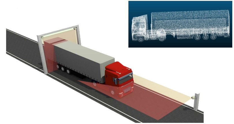
3D profiler based on laser scanners and an example of the resulting cloud of points
Both the lidars themselves (thanks to autonomous transport for this) and software for them, which solves the problem of analyzing a cloud of points for identifying features (wheels, trailers, cargo, number and location of glasses, etc.), are continuously being improved. Low-cost lidars without a rotating mirror, which fit in the nest of a conventional fog for use in machine vision systems of autonomous cars (which, in general, is also not for us, are beginning to bring to the market, and the water is opaque snow guaranteed blind most sophisticated AI).
Users of the classic toll road are familiar with the concept of a transponder - an electronic gadget with which you can drive to a payment center without stopping. For technical details I ask again in my article ( link ). The number of transponder users is gradually increasing; in the summer season, a crush begins behind them. But only recently the main problem was finally solved and the last serious obstacle to transponder happiness was removed - now with a single transponder you can drive along most toll roads. No, it is clear that this is an obvious user request. But when you read the forums of European truckers, you will understand that each of them is forced to carry a whole collection of onboard devices (the so-called grand piano ) to pay for travel, fuel, environmental fees, etc. That is, they do not have a single device and soon will not. The problem is not technical, but rather evolutionary. In 2012, we still had a chance to do “as in Europe”, but for once we have done better. After several years of development, aggravated by multilateral harmonization, with weekly meetings against the background of continuous adjustment of requirements as the parties mature, we finally got an inter-operator interaction IS, made in accordance with European ISO standards.
Within the framework of IP, the following roles were identified:
- Transponder Issuer providing lists of transponders issued;
- A service provider recording the parameters of a vehicle traveling through fast lanes of PVP
The IC architecture of inter-operator interaction is based on a distributed cluster of primary nodes, each of which contains a copy of all data, including lists of transponders, security keys, drive records using transponders, various adjustments made by operators, etc. The toll road operator who wants to connect to the system now only needs to bring their data to a standardized form, implement the exchange protocol and upload the “roaming” keys to their DSRC antennas so that they can correctly register the passages of the “alien” users. Since the basic contents of the transponder memory are fixed by the ISO 14906 standard, which is sacredly honored by all participants, the main problems arose in the field of data corrections and in general mistrust of the operators to each other (which actually gave rise to a similar to the blockchain data replication architecture).
Obviously, the future belongs to the technology of electronic charging (see my article on this topic). Only these technologies allow charging in free-flow mode, without barriers, capital structures and traffic jams during peak hours. But the bright expectations from systems based on satellite positioning technologies, on the contrary, had to be significantly adjusted. This is due to the harsh reality and practical experience of the implementation of "Plato".
Guest from the future
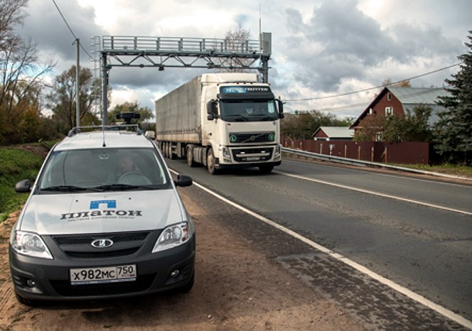
Mobile and stationary posts control system "Plato"
The fate of the 12-ton road collection system (aka Plato) is dramatic and painful, starting from the competition canceled in 2014 with the participation of the world's technological giants and the largest banks and ending with the heroic commissioning of the system just a year later by Rostec. Nevertheless, if you close your eyes to errors and omissions, in purely technological terms “Plato” stands on the top of a mountain of toll systems. What is both good and bad, and then I will explain why. By the way, you can remember the materiel here: one , two .
Technological novelty of “Plato” and similar systems consists in the idea of completely refusing to use the land-based stationary infrastructure for the purposes of charging. Instead, data on the use of toll roads are based on the binding of GPS tracks to the road graph. The advantage of this approach is the possibility of covering the entire road network with a fee-paying mode. For example, “Plato” covers all 50,000 km. federal roads. At the same time, it is possible to change the network configuration, add or exclude segments, enter various tariffs: for mileage, for the site, for part of the site, etc. It is even possible to combine several networks and several operators within one system, for example, the federal network and regional networks (a structured approach to defining the context of charging is given in the ISO 17575- * standards).
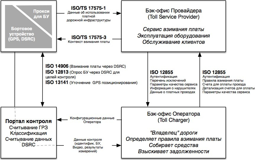
Hybrid Toll Collection Standard Architecture
And then the minuses begin. First, the ground infrastructure was not completely abandoned. This class of systems requires additional control over the implementation of charging rules. Therefore, they began to install stationary control portals (more than 400 portals) throughout the entire network of federal roads, and control cars (numbering more than 100) were launched on the roads. Secondly, during the project, unpleasant surprises began to arise.
The fact is that similar western truck toll systems use onboard GPS trackers combined with DSRC transponders (Germany, Slovakia). When driving through control portals from a vehicle equipped with such a tracker, the system receives the following information: a class (determined by a laser scanner), a photo with a recognized number, as well as read DSRC data that facilitates user identification and includes, for example, the vehicle class and its license plate. The monitoring portal can offline verify DSRC data and direct measurement data and with a high degree of confidence decide on the fact of a violation, and more precisely on the fact of non-violation .
In Plato, apparently due to cost savings, it was decided not to add DSRC modules to the trackers. The task of identifying the intruder in a mud-stacked truck, which rushes in the middle of the night under the portal of control, has become dramatically more complicated - now there are no two independent means of identification. In bad weather, the readability of license plates falls from the usual 96-97% to 60-70%, and in the snow and after it often only every third license plate is read. Where does the secondary source of reliable identification data come from? You can, for example, take a partially read license plate and verify it with the database of registered users. But everyone who was engaged in license plate recognition technology will only laugh at it, since the plate is usually contaminated either uniformly all or bottom-up, so the recognition results subside immediately over the entire plate. According to the database, you can try to restore only the numbers of amateurs to stick separate figures, but they do not make a weather

If the speed control system can afford to fix the vehicle through one thing (they will still be afraid), then the control portals should not let through any cars, with or without a license plate, because all this is the money of the “owner” of the toll road.
The second idea is to restore the data on the passages under the portal from the received tracks and try to compare them with the results of observations. It sounds good in theory, but in practice it turns out terribly, because after binding a track to a map, only identifiers of road segments remain in the system, the travel time along which is somewhat different from the time under the portal. You can also force the tracker firmware to issue a special data packet when driving through an area that coincides with the portal (the so-called geo-fencing). But it will require to store in the memory of the tracker and promptly update the coordinates of all portals. Yes, and this technology itself on small objects works with errors.
Generally speaking, linking the track to the map in order to calculate the path is still a problem! Especially if the quality of the invoice directly depends on the accuracy of the binding. In a dense road network, where paid and free segments are close to each other (for example, a free doubler parallel to the toll road), GPS track jumps can lead to erroneous billing. In the mountainous area, in tunnels, under overpasses, at interchanges, in the forest, near high-rise buildings or near the Kremlin, there is no trust in the GPS data at all, and software developers excel as they try to keep the vehicle on the route from indirect data. In such conditions, without additional “beacons” on the road, nothing can be guaranteed. All the same DSRC antennas that form a neat “spot” on the road come to the rescue. The ISO 13141 standard describes the LAC (Localization Augmentation Communication) service, which allows you to install inexpensive standalone DSRC beacons, the only function of which is to record a fixed data block with coordinates and timestamps in the memory of the control unit, which is 100% evidence that the vehicle has reset the beacon spot. Logic BU uses this data to clarify the GPS track.
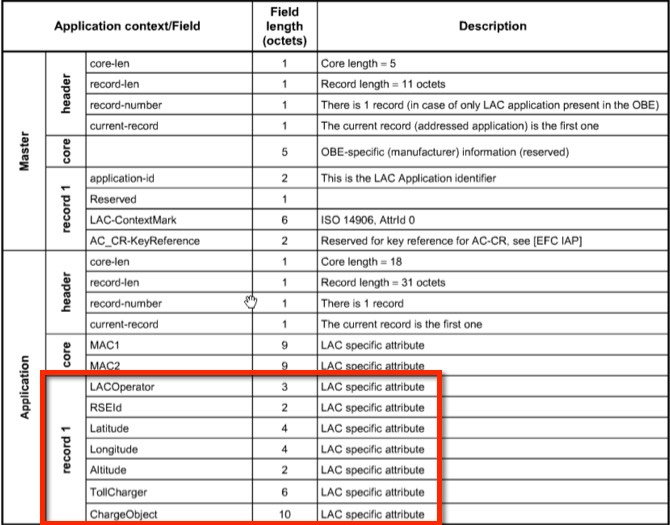
An example of ISO 13141 DSRC data complementing GPS tracking
The near future of toll road technology
Everything goes to the fact that the barriers on toll roads should disappear soon, and robbing motorists will become an electronic way and at full speed. On the way to happiness, we now have three problems:
- Axis classification. As mentioned in this article, it is quite difficult to see the axles at full speed. And if they are raised? In general, it would be nice to refuse to take axes into account when calculating the tariff. For example, instead of the number of axles, you can use the length of the vehicle.
- Weak legal framework for primitive violators. The toll road operator has almost no legal basis to fine violators, and if he now has the right not to let the vehicle on his way without payment, then they will be taken away from him in the free flow mode.
- Porridge in the head of the designers when choosing the right technology of charging in each case.
Among the listed problems, only the latter belongs to the technological category. We will analyze it by the example of the largest infrastructure project of the next two years - the Central Ring Road . In the press recently flashed that the free site near Zvenigorod want to launch this year.
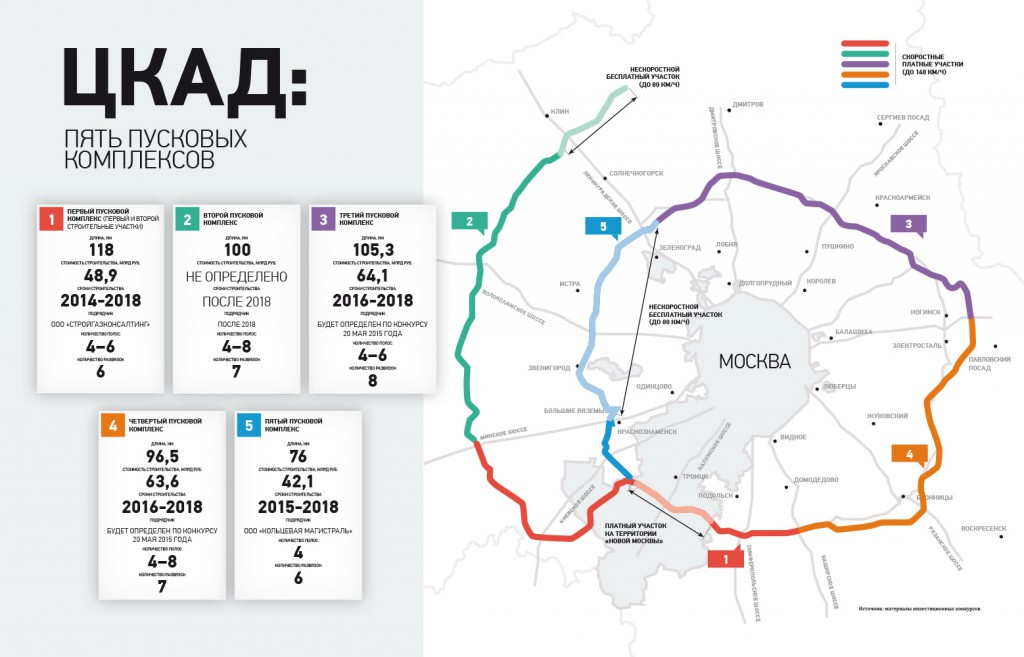
Central Ring Road - the first toll road in the Russian Federation, which, most likely , will do without barriers
Currently, there are three main technologies for free-stream charging: GNSS — based on track binding, DSRC — using transponders, ANPR — using license plate recognition. Here is a comparative table of the charging system parameters on the listed technologies (RFID and manual collection are added to complete the picture):
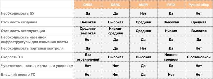
Comparative parameters of charging technologies ( via ).
The choice of charging technology is inextricably linked to the cost of creating and operating a toll road - after all, all future projects are investment in nature, and the cheaper the object is, the less (in theory) there will be a fare for it.
This is how technologies are distributed depending on the type of project.
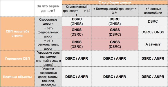
Technology selection map. ( via )
As you can see from the picture, it only makes sense to bother with GPS trackers on large road networks and if our client is commercial vehicles. The complexity of the road network is determined by the number of segments, which are usually determined from the exit to the exit. Here is how the choice of base technology is determined depending on the number of segments:
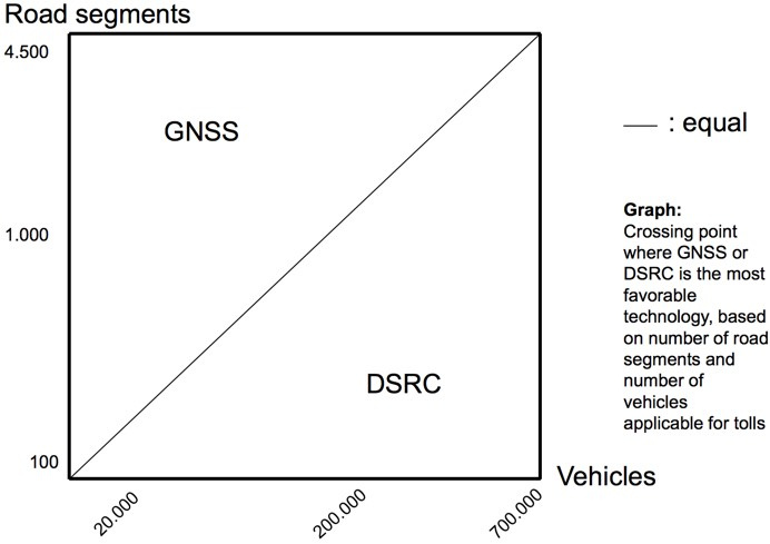
Selection of technology depending on the number of road segments and the number of toll road users ( via )
As we can see, on toll roads, where a small number of segments and a large number of users, such as a Ring Road (which, despite its length, will have no more than 30 segments), it makes sense to use portals with DSRC antennas for paying for travel and with video cameras for control violations. It is both efficient and technologically, and in terms of the cost of creation and operation. Especially as the users of the existing toll roads will go along the Ring Road, which by that time will overwhelmingly switch to a single DSRC transponder. At the same time, it is highly desirable to oblige all users of the Central Ring Road to use transponders (they can be given below cost or even free of charge with a subscription, it will still pay off ten times). For passenger vehicles, it is possible to distribute “transponders in a package” - a ready-to-use solution that allows you to create a temporary user registration with an initial balance when you first travel under the portal. Such “charged” transponders can be sold at gas stations or even through vending machines.
In the urban environment and on the objects of the toll road infrastructure, DSRC technologies should be supplemented with payment technologies based on license plate recognition results. In the city it is impossible to demand from each and every one the availability of a transponder, you can only gently hint and entice discounts. At the same time, license plate recognition cameras can simultaneously monitor violators. For example, a paid entry into central London is organized in the same way. And in Moscow, the paid parking system in the center identifies customers by license plates.
But what about RFID, colleagues can ask me, is it also used to identify vehicles? Of course, RFID, as well as DSRC, is a promising direction and toll roads are also used on it (for example, in the USA and in Southeast Asia). On the pros and cons, I can orient in the comments, but, briefly, if we have already created and have 5 years of infrastructure for DSRC, put into operation a single transponder, the technological field is painted in a series of standards, the device itself costs no more than 10 euros (which is comparable at a cost with high-speed automotive RFID tags) and has a battery for 7 years, then what else can you think? And also - the DSRC transponder can pinch and flash a light bulb, indicating the status of the operation! It seems to me that the RFID train in part of the domestic toll roads is gone. But the identification of vehicles for control purposes (aka electronic license plates) is a task for RFID tags. But that's another story.
Source: https://habr.com/ru/post/330876/
All Articles