OpenStreetView launch

After nearly a year of planning, development and testing, representatives of the OSM community at Telenav presented the free and open platform OpenStreetView for capturing and publishing surrounding views from a smartphone. This is great news for the whole OSM community: on free maps, photos of the surrounding area will now appear, tied to maps. It’s not as beautiful as Google’s proprietary maps, but it’s quite natural: Google spends about $ 1 billion annually keeping its maps up-to-date to become a reference source of maps for the whole world.
Why use OpenStreetView maps, if there is a technologically more advanced Google StreetView - popularly explained in the article “ Why the world needs OpenStreetMap ” from Serge Wroclawski. In short, the answer is that geo-data are too important for one corporation to have a monopoly on them, to have the right to decide what to show on maps and what is not, and also to monetize geographical maps. That is why people just need free OpenStreetMap maps.
OpenStreetMap is a non-profit cartographic project for the community to create a detailed free and free geographical map of the world. To create maps, data from personal GPS trackers, aerial photographs, videos, satellite images, as well as knowledge of the person who edits the map are used. As articles are edited in Wikipedia, any user can also edit the map in OSM. Project data is distributed under the terms of the free license Open Database License. The project is supported by the non-profit organization OpenStreetMap Foundation, existing through donations.
')
The OSM project has been developing very successfully since its foundation in 2004, and in some places provides more detailed and high-quality terrain coverage than Google Maps or Yandex.Maps.
For OSM, a lot of support programs, map editors (the most popular among them - JOSM ), navigators and routers have been created. OSM data itself is used in many commercial services, for example, Apple Apple maps on iOS, on Flickr, Foursquare, Wikipedia and many other sites.
The new OpenStreetView feature makes OSM maps even more convenient to use - and therefore can increase their popularity.
The OpenStreetView (OSV) platform includes the openstreetview.org website, iOS and Android open source mobile applications, a specialized map editor, an early beta version of the plugin for the offline JOSM editor, and a backend server, says one of the developers. Support for online JavaScript editor iD is planned.

The mobile application recognizes traffic signs, processing 60 FPS video on the client side
On the website you can view photos, study the leaderboard, as well as your own profile and trips. Of course, in the latter case, you need to log in: the OSV account is tied to the OSM account. By user ID there is an opportunity to see what information about it is publicly available (for example, the number of trips): by the link like https://www.openstreetmap.org/api/0.6/user/8909 , where instead of
8909 necessary OSM ID is inserted .In Russia, someone has already tried out shooting OpenStreetView on the Moscow-St. Petersburg expressway. So far, this is the only OSV user in the Moscow region. For comparison, in San Francisco, activists have already filmed almost every street in the center .
The mobile application OpenStreetView is published in the Google Play catalog and in the AppStore . For Android, there is a direct link to the APK (35.85 MB).
The mobile application is optimized to work in the car, but it can be used on a bicycle, and when walking on foot. The photos are automatically linked to the terrain and automatically uploaded to the OSV servers as soon as the WiFi connection appears (this changes in the settings if the automatic transfer is inappropriate). But, in principle, the application allows you to effortlessly remove the surroundings and replenish the base of free maps, as well as view the footage on the phone.

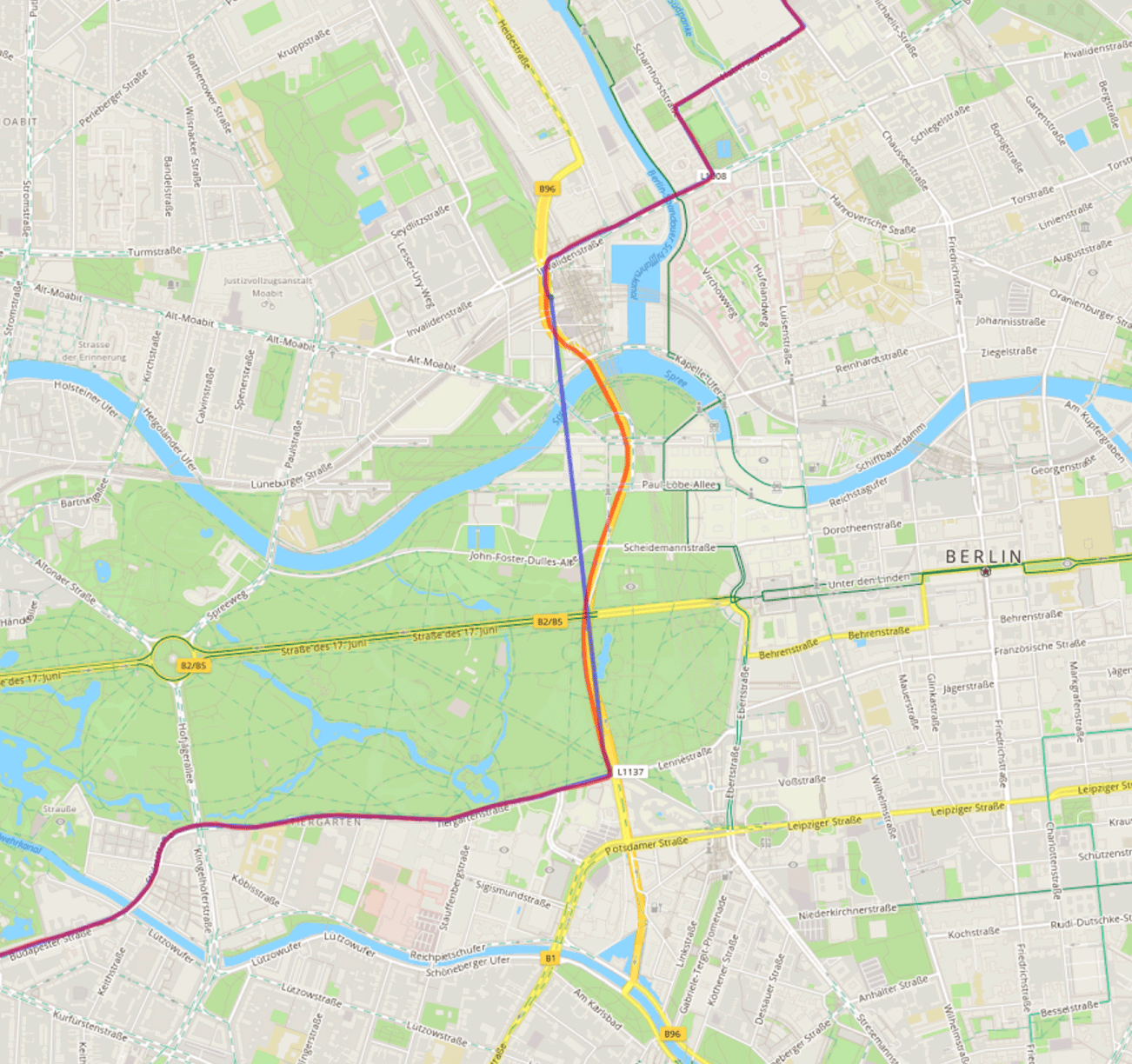
The application itself creates an account on OSV, allows you to log in via OSM OAuth. It even supports synchronization via the OBD2 vehicle diagnostic port. If you install an inexpensive OBD2 module , the program will receive information about the speed and maneuvers of the vehicle in real time - and improve the positioning, which is initially based on the GPS signal. In this way, you can shoot the territory where the GPS signal is not caught - in tunnels or in dense forest. As an example, the OSV developer shows a map of the Berlin route, where only GPS is marked in blue, and OBD2 is corrected in red.
Developers from the OSM project talked about OpenStreetView at the State of the Map conference ( video ).
Martin Van Exel (Martjin van Exel) in his speech says that through OSV you can attract even more participants to the OSM project, because it is very interesting to shoot the neighborhood while riding a bicycle or a car!
Source: https://habr.com/ru/post/308246/
All Articles