TerraServer useless service or missed opportunity?
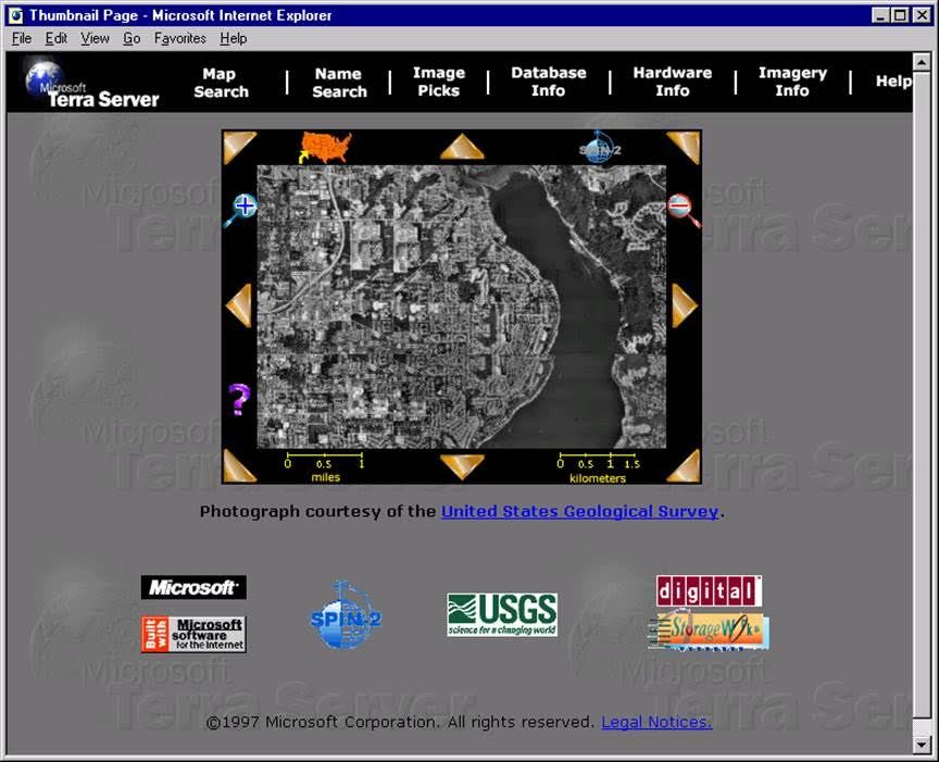
Even before Google Maps in 1998, Internet users had the opportunity to visit another city, country or continent, without leaving their homes. It was the world's first largest online atlas, which combined both satellite and topographic images of the Earth. The project was called TerraServer and contained more than 8 TB of data with images from the United States Geological Survey (USGS) and SPIN-2 (SPIN-2), which were processed by the SQL database. This project had only one goal and it was not at all to help users sitting in front of the monitor to “fly” across the horizon. No, the goal of TerraServer was to demonstrate the capabilities of Microsoft: the company's software could handle the largest database without any problems.
Microsoft commissioned Tom Barclay to place the entire planet in databases inside a Compaq computer. To fit thousands of kilometers of our planet just 100 m 2 - it was a miracle.
')
It was planned that TerraServer will become the key to Microsoft’s leadership among Internet companies in the 21st century. It was the very first publicly accessible interactive satellite map of the world and the first SQL database of a few terabytes of land. In fact - it was the largest database in the world in a few years and Compaq was considered the largest computer in the world. TerraServer was a functional and popular predecessor of Google Earth, which allowed you to see your home from space. He worked long before Google thought about this concept.

So why don't we use TerraServer on our smartphones now?
Probably for the same reason why Microsoft lost the Google competition for leadership in the field of search resources, email, browsers and other consumer services. Microsoft didn’t particularly care about user experience when using TerraServer. They also did not care about the huge amount of user data that remained after using the service.
In the words of Tom Barclay:
The original plan was only to create a database. The corporation didn’t care what was contained there, it just wanted to be huge. For what? The database was supposed to be the largest in the world to test the scalability of Microsoft SQL DBMS.
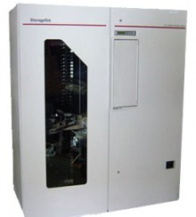
The database continuously backs up to the StorageTek 9710 TimberWolf automated tape module using SQL backup integrated with the Legato network. In online mode, the backup process uses 20% of the CPU resources and takes approximately 8.5 hours, including time to make changes to the tape.
As Barclay said:
It turned out that finding an interesting and real terabyte of data that could be freely used and legally distributed was very difficult. According to a USA Today article from June 22, 1998, the initial task for TerraServer was to list every transaction in the history of the New York Stock Exchange and make it searchable online. But in the end, the database size was only 500 GB, which was not enough. Microsoft demanded more. In 1997, the United States Geological Survey downloaded its halftone (black and white) satellite photographs and other aerial images from its archive onto the Internet. Hedi Rossmeysl of the US Geological Survey met with the famous Microsoft programmer Jim Gray, they began to think about the possibility of combining projects into one. After all, placing satellite images on the Internet so that they are in open online access at any time and in any place was not only interesting, but also useful.
The time was more or less appropriate. The Cold War ended, which allowed declassifying photos taken by spy satellites. Nobody in the world was afraid of terrorism (before the tragedy of September 11), more and more people were discovering the advantages of using the Internet.
According to Rossmeysl:
The images, along with some declassified military photographs of Russia, amounted to just over 2.3 terabytes. Gray appointed Barclay (whom Rossmeysl called the “brain of the project”) responsible for the development and he began coding. TerraServer was his first website he ever did. This was his first project, which had at least some relation to cartography. But the task was quite difficult, Barclay very quickly ran into the main problem of cartography. Transferring the rounded surface of the earth to a flat monitor became a real headache for him.
He decided that using the standard Mercator projection is not the solution to use. Such a projection distorts the size of the continental arrays, since the movements will occur not only along the equator, but also to the south and to the server. The projection of the Mercator is special in that it does not distort angles and shapes, the distance is maintained only at the equator. To this day, this projection is used to compile marine navigation and aeronautical charts.
After unsuccessful testing of various methods, Barclay put forward the idea of creating “mosaic” images that can be generated depending on the selected part of the map. Most of the images taken by Microsoft from the US Geological Survey were merged together, but then cut into smaller squares and re-centered with the team.

As Barclay said:
Innovation was revolutionary, the strategy of "Mosaic" became the basis for Google Earth and Google Maps. It's amazing how similar the modern technology to technology in 1997. When the map display problem was solved, TerraServer was launched and the fun began.
TerraServer started back in 1997 and today it would have already reached its majority. But unfortunately, we have no way to use it. The project went offline in 2007, since then Barclay spent most of his time working on Bing Maps. Microsoft periodically restored TerraServer (even after 2007). In addition to the USA Today article, the project was also devoted to articles in the New York Times and Newsweek. They described concerns about the potential intrusion into the privacy of users while using the system. For example, the title of one of the articles read: “Surveillance in the sky”.
Microsoft held the launch ceremony in New York, which was attended personally by Bill Gates. On the first day of work, 8 million users got access to the project, and by the end of the week, 30 unique visitors were registered per day (according to a report published in 2000). In the end, the surge in popularity faded away and the project was visited daily by 7 million users. TerraServer has become more successful than Microsoft had expected.
It's amazing how much data about general web behavior could be collected at Microsoft. But it is even more striking how thoughtlessly all this was used. The company TerraServer was considered as another novelty, and not as a project that could change the world. It is noteworthy that in Microsoft (even before Google) they established one interesting fact: a person will be very upset if he doesn’t see his house or familiar area on the picture taken, respectively, the project will be useless for him.
From the memories of Barclay:
A collection of various articles about TerraServer centered around its ability to handle the largest database. At the same time, it was almost completely ignored how much user habits data he could collect.
The Times article mentioned:
Microsoft's strategy to use TerraServer is to prove that its software and operating system are suitable for massive databases. Funny fact - the company's specialists found that the Internet is the most lively on Mondays and Tuesdays. The obtained information was used by the company only to determine when it is best to work on the servers in the data center. The only revenue Microsoft got from using TerraServer came from sales of satellite images sent to users by mail. The cost of such images ranged from $ 7.95 to $ 24.95.
Now, Terraserver is a monument to Microsoft’s missed opportunity to dominate the computing technology market. It is difficult to say why the company decided to stop developing its project. Perhaps this is due to the death of Jim Gray (boss Barclay) in 2007 on the high seas.
Microsoft commissioned Tom Barclay to place the entire planet in databases inside a Compaq computer. To fit thousands of kilometers of our planet just 100 m 2 - it was a miracle.
')
It was planned that TerraServer will become the key to Microsoft’s leadership among Internet companies in the 21st century. It was the very first publicly accessible interactive satellite map of the world and the first SQL database of a few terabytes of land. In fact - it was the largest database in the world in a few years and Compaq was considered the largest computer in the world. TerraServer was a functional and popular predecessor of Google Earth, which allowed you to see your home from space. He worked long before Google thought about this concept.
So why don't we use TerraServer on our smartphones now?
Probably for the same reason why Microsoft lost the Google competition for leadership in the field of search resources, email, browsers and other consumer services. Microsoft didn’t particularly care about user experience when using TerraServer. They also did not care about the huge amount of user data that remained after using the service.
In the words of Tom Barclay:
This was done to show that our software is capable of such. But the company absolutely did not care about the collected information. Google was originally an information company, aware of the value of information.
The original plan was only to create a database. The corporation didn’t care what was contained there, it just wanted to be huge. For what? The database was supposed to be the largest in the world to test the scalability of Microsoft SQL DBMS.
The database continuously backs up to the StorageTek 9710 TimberWolf automated tape module using SQL backup integrated with the Legato network. In online mode, the backup process uses 20% of the CPU resources and takes approximately 8.5 hours, including time to make changes to the tape.
As Barclay said:
We were asked to work on a very large database, to test the next generation database.
It turned out that finding an interesting and real terabyte of data that could be freely used and legally distributed was very difficult. According to a USA Today article from June 22, 1998, the initial task for TerraServer was to list every transaction in the history of the New York Stock Exchange and make it searchable online. But in the end, the database size was only 500 GB, which was not enough. Microsoft demanded more. In 1997, the United States Geological Survey downloaded its halftone (black and white) satellite photographs and other aerial images from its archive onto the Internet. Hedi Rossmeysl of the US Geological Survey met with the famous Microsoft programmer Jim Gray, they began to think about the possibility of combining projects into one. After all, placing satellite images on the Internet so that they are in open online access at any time and in any place was not only interesting, but also useful.
The time was more or less appropriate. The Cold War ended, which allowed declassifying photos taken by spy satellites. Nobody in the world was afraid of terrorism (before the tragedy of September 11), more and more people were discovering the advantages of using the Internet.
According to Rossmeysl:
We had digital images of half the countries on planet Earth. We also had the opportunity to provide pictures to people, but not in a fast and convenient way.
The images, along with some declassified military photographs of Russia, amounted to just over 2.3 terabytes. Gray appointed Barclay (whom Rossmeysl called the “brain of the project”) responsible for the development and he began coding. TerraServer was his first website he ever did. This was his first project, which had at least some relation to cartography. But the task was quite difficult, Barclay very quickly ran into the main problem of cartography. Transferring the rounded surface of the earth to a flat monitor became a real headache for him.
He decided that using the standard Mercator projection is not the solution to use. Such a projection distorts the size of the continental arrays, since the movements will occur not only along the equator, but also to the south and to the server. The projection of the Mercator is special in that it does not distort angles and shapes, the distance is maintained only at the equator. To this day, this projection is used to compile marine navigation and aeronautical charts.
After unsuccessful testing of various methods, Barclay put forward the idea of creating “mosaic” images that can be generated depending on the selected part of the map. Most of the images taken by Microsoft from the US Geological Survey were merged together, but then cut into smaller squares and re-centered with the team.
As Barclay said:
We failed to do it the first time. At the presentation of the first demo version, the house of Bill Gates was divided into two parts, which was not very good. We have completed the progressive deployment of the map. This allowed people to center any desired area. Also realized the possibility of increasing and decreasing the scale.
Innovation was revolutionary, the strategy of "Mosaic" became the basis for Google Earth and Google Maps. It's amazing how similar the modern technology to technology in 1997. When the map display problem was solved, TerraServer was launched and the fun began.
TerraServer started back in 1997 and today it would have already reached its majority. But unfortunately, we have no way to use it. The project went offline in 2007, since then Barclay spent most of his time working on Bing Maps. Microsoft periodically restored TerraServer (even after 2007). In addition to the USA Today article, the project was also devoted to articles in the New York Times and Newsweek. They described concerns about the potential intrusion into the privacy of users while using the system. For example, the title of one of the articles read: “Surveillance in the sky”.
Microsoft held the launch ceremony in New York, which was attended personally by Bill Gates. On the first day of work, 8 million users got access to the project, and by the end of the week, 30 unique visitors were registered per day (according to a report published in 2000). In the end, the surge in popularity faded away and the project was visited daily by 7 million users. TerraServer has become more successful than Microsoft had expected.
It's amazing how much data about general web behavior could be collected at Microsoft. But it is even more striking how thoughtlessly all this was used. The company TerraServer was considered as another novelty, and not as a project that could change the world. It is noteworthy that in Microsoft (even before Google) they established one interesting fact: a person will be very upset if he doesn’t see his house or familiar area on the picture taken, respectively, the project will be useless for him.
From the memories of Barclay:
In the first year of the project, I received more than 20,000 letters in which two opposites were most often written: “I love TerraServer, I saw my house” or “I hate TerraServer, my house is not there”. We found out that 85% of all geo requests were local. People wanted to find places near their home, be it dry cleaning or some fast food.
A collection of various articles about TerraServer centered around its ability to handle the largest database. At the same time, it was almost completely ignored how much user habits data he could collect.
The Times article mentioned:
Microsoft's strategy to use TerraServer is to prove that its software and operating system are suitable for massive databases. Funny fact - the company's specialists found that the Internet is the most lively on Mondays and Tuesdays. The obtained information was used by the company only to determine when it is best to work on the servers in the data center. The only revenue Microsoft got from using TerraServer came from sales of satellite images sent to users by mail. The cost of such images ranged from $ 7.95 to $ 24.95.
Now, Terraserver is a monument to Microsoft’s missed opportunity to dominate the computing technology market. It is difficult to say why the company decided to stop developing its project. Perhaps this is due to the death of Jim Gray (boss Barclay) in 2007 on the high seas.
Source: https://habr.com/ru/post/306358/
All Articles