Urban design: 4 lectures on the creation of navigation schemes in the subway and not only
It was recently in Projector , where designers (project managers) gathered who were engaged in improving navigation in the metro (and not only in the metro) in Moscow and Kiev.
Alexey Radchenko, who led the development of a unified transport navigation system for Moscow (and in the metro too) in 2014, came to Moscow from this lecture session.
')
The lectures will talk about:
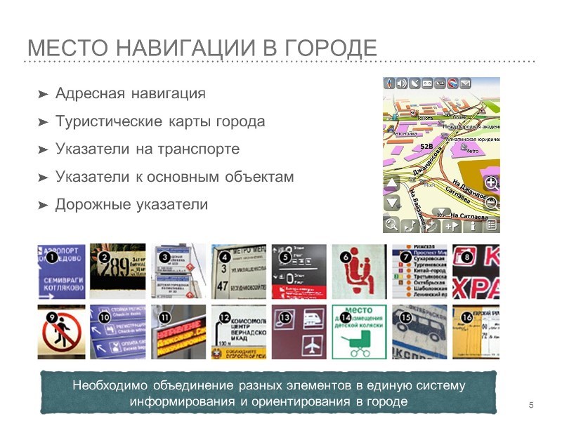
- what is navigation?
- what should it be?
- how to make it convenient and understandable for people and how to constantly improve it?
- how to interact with all sorts of "reinforced concrete" in the image of thought by state bodies that are responsible for navigation?
- examples of navigation design from other cities
- the guys from " Agents zmin " talked about how they created the navigation schemes for the Kiev metro
- how do studios (not Lebedev) work that specialize in the development and design of navigation schemes for cities?
and much more about the design of the urban environment in terms of navigation. The lecture is overlaid with slides so that you can immediately see clearly examples of what the speaker is talking about.
Lectures will be of interest to anyone who is interested in design in general, urban design and design of navigation schemes in particular. Also, the lectures will be of interest to project managers, since everything related to urban design projects requires more management skills than in regular business projects. What is worth the constant work with government agencies and the approval of all projects in these departments.
Lecture on the creation of a unified transport navigation in Moscow in 2014
The guys from Agents zmin told about how they created the schemes for the Kiev subway. It is particularly interesting how the guys investigated the question: how they gathered information, how they worked “in the field”, how they made up the concept of TPD (decision points), etc.
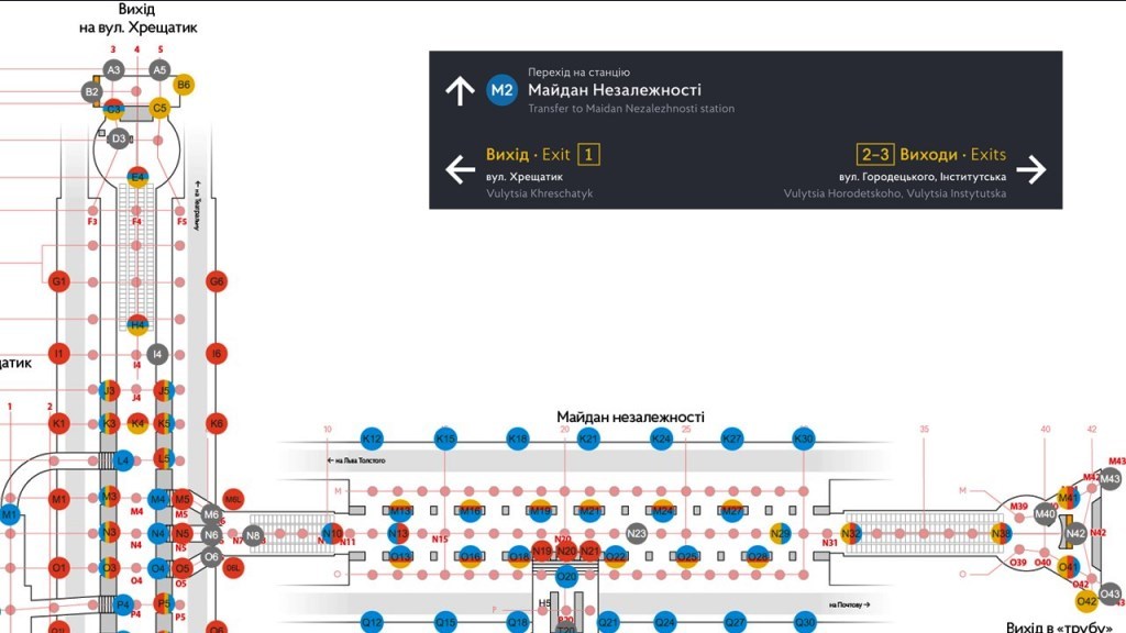
Lecture by Yuri Granovsky on the development of scenarios for navigation systems, for example, the redesign of the Kiev metro schemes. Especially interesting was the scheme that they developed for the key stations of the Kiev metro. For example, is a person standing before the transition and how many options does he have for action: 3? four? ten? And I especially liked that, it turns out, not only it seemed to me that the transitions between Khreshchatyk and Maidan Nezalezhnosti are incomprehensible to anyone, especially the newcomer, and those who have not been there for a long time, painfully recalls each time - and in what transition from this cave then you will not leave)? And the number of those who made the mistake is very large, it’s not just me that turns out to be so!
I especially liked this scheme of TPD points - I did not expect that there could be so many of them.
Igor Sklyarevsky, in conjunction with the previous lecture, talked about how they investigated the issue, because it is good to sit in an office and develop a design for the metro, but it would be better if you did it with your legs, i.e. with your feet (body) measure the distance / time of transition from station to station, etc. The amazing discovery for me was that those aunts who are on duty at such nodal stations answer up to, it seems, 500 questions a day from the subway passengers “How to get there?”, Although there seems to be a scheme (information) - but does not work. For research, the guys pretended to be such “losses” to find out what is needed for a person who wants to comfortably use the Kiev metro. Then they put on vests with the letter “and” and were such volunteers who helped such “losers” find their way, and, accordingly, recorded all the requests - very interesting statistics!
The second lecture by Alexey Radchenko about maps and industrial design for urban design. A few words about maps, about why electronic maps for offline navigation are not suitable, about what they should be, then a very large and interesting part about what materials are made signs / signs / scoreboards, etc. what kind of carriers are used for what purposes - its use depends on the carrier, an important moment is the price of these carriers for the city, interchangeability. All this with examples, not only from Kiev / Moscow, but also from other cities.
For me personally, such lectures always help in solving completely different issues that are absolutely unrelated to design as something graphic, because design (according to Victor Papanek) is always the solution to the problem in the first place, and graphic content is only the final result And the result may not always be graphic, the main result is the solution of the problem, therefore, I believe that all people are to some extent designers.
Post sponsor: Cosmonova: data centers & telecom & software developer
Source: https://habr.com/ru/post/301842/
All Articles