The technology of mass distribution of information Geotalk
Good time.
Not so long ago, we talked about our project Geotalk . We continue to develop the concept and at the moment have approached the development of mass information dissemination technology. If you want to know how the unique technology is developing, and discuss how useful it is, welcome to Cat.
Concept development
')
Geotalk develops from a chat-like application that takes into account the user's location in each message. Developing the application, we are trying to expand the existing framework and bring the exchange of information to a new level. The question immediately arises, “What is such a level and what, in fact, does not suit the existing one?”. Traditionally, information is distributed through TV, radio and newspapers. The Internet has recently joined this set, with its blogs and social networks. Maybe this toolkit will seem to someone enough, but in our opinion, the existing means of information exchange “suffer” from chronic problems and here are some of them:
- The bias towards global news and events;
- Subjective determination of the importance of news and events;
- It is difficult for an ordinary person to become a source of news and events;
- No direct access to the target audience;
That is why we decided to develop a new information exchange service. Further, a deeper description of these problems will go (the description is subjective and not supported by scientific theses).
We read daily news feeds that tell us about current events. Most of them are news and events of global or state significance.
Only a small part of the information of the city level falls on the monitor screen. For a number of reasons, news feeds cannot afford to “sink” to a lower level and publish news of a particular district or village, events at the level of the regional drama theater or a separate school institution. Does this mean that nothing happens at these levels or the news and events of this magnitude are not important for people? Quite the contrary, the closer information is to a person, the more important it is to him. The problem is the lack of a tool that allows you to distribute local information on a par with global.
The determination of the importance of information by traditional media is a matter of controversy and which will remain open for a long time if nothing is done. Who and why decided that I was interested to know about the current political situation in the neighboring state? An ordinary person cannot determine his or her range of interests and influence the assessment of the importance of an event. From this follows the question of manipulating public opinion, but we will not now dive into this topic. I hope everyone who reads this article shares the view that there is no doubt that there is manipulation of public opinion through the media.
There are many sources of information. But each source has its own unwritten rating. Information from the press secretary of the president is much larger than the statement of the regional deputy. Even if you have very important information, it is often very difficult for you to spread it because the average person has practically no opportunity to become a source of news.
The issue of reaching the target audience stems from the previous problem. The messages themselves have no value if they cannot reach the target audience. We do not say that there is no targeting on the modern Internet. On the contrary, targeting is now placed at the forefront and is actively developing. In our opinion, one of the most important criteria for the target audience is its location. As proof, think about the fact that a person living in the American provinces is unlikely to want to read the news about Moscow traffic jams written in Russian. We believe that the closer information is to a person, the more relevant it is to him.
I tried to summarize our understanding of the problem as short as possible, but I hope the scale of what is happening was described quite clearly. We responsibly approached the issue and tried to develop a technology that allows you to create an application that eliminates the shortcomings of modern means of disseminating information.
How Geotalk Technology Works
The key meta-information in technology is the location of the user. Therefore, to use the service, you must have a device that can determine geo-location. When a user connects to a service, his location is determined, and he can immediately receive information, which is presented in the form of a news feed and events, which, in turn, are sorted by a special timestamp.
At the moment we did not create bots and news parsers, therefore, in order for news to appear in the feed, they must first be published. To post a message, you must register. When a user registers, he receives a positive personal rating for distributing messages. This rating allows you to extend the published message for several kilometers around the user.
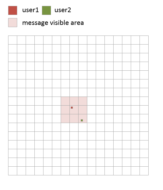
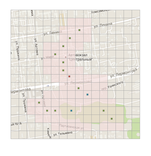
The figure below shows the coverage area of the message that the new user published (the author of the message). All users who are in the coverage area will be able to see this message.
If users who are in coverage will find the message useful, they can relay it. Thereby increasing the coverage in proportion to the level of its rating. For the distribution of messages, as well as for publication, registration is required.
The figure below shows the coverage area of a message, after another user with an initial rating relayed it.
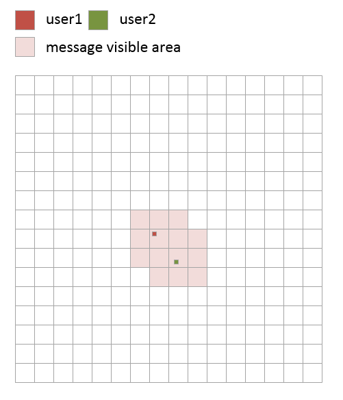
When the user relays someone else's message, he also raises the personal rating of the author of the message. In this way, the rating of the authors whose messages are relayed is gradually increasing and, together with the rating, the coverage area of new messages that the author will publish increases.
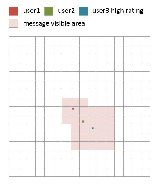
Personal rating also affects the distribution zone of messages from other authors. If the user has a large personal rating and he forwards the message, the coverage area of the message will increase in proportion to the user rating. If the coverage area is already increased to the limit, then simply increases the personal rating of the author of the message. The figure below shows how the coverage area of a message will increase if it is relayed by a user with a high rating.
If we impose this grid on a real map, we will see how the message spreads over the surface of the planet.
A formal block diagram of the technology algorithm is provided below. As you can see, it is very simple.

In simple terms, this is similar to broadcasting, where the user is both the receiver and the transmitter, with the difference from the radio that the user can move, and the transmitter power can change depending on the user's rating. Note: it is for this analogy that we called the button for distributing messages "ON AIR".
In short, the whole technology can be described as follows: Each published message is necessarily supplied with real geo coordinates. The user has a rating due to which his messages get a visibility zone. The higher the user's rating, the greater the visibility zone of his messages and the more people will be able to see them. If those who saw the message find it useful, they can support the message by increasing its visibility proportionally to the size of their rating.
Messages spread over long distances, only when they are really important, and geolocation is involved in calculating the degree of importance. Thus, if you publish a message that a tractor is free to work in a village, only the villagers will see this message. But if a meteorite fell in your village, the message is able to spread around the planet with lightning speed and will appear in the news feed of all users of the application.
We did not mention about another goal of the service - equal conditions for all authors. In order for users to see all messages in one tape, they had to enter a special timestamp for sorting messages. Using this tag, we allow users to see the most important messages and at the same time not to miss new ones. So far we are testing this mechanism and therefore the tape with new messages is separately available where traditional sorting by date is used.
You can touch the prototype of the application here thegeotalk.com . The prototype implements the basic set of technology capabilities, but in the future we plan to implement the following ideas in the prototype:
- Subscription system;
- The ability to unite in groups for publication in a large area of visibility;
- The ability to use several "transmitters" placing them on the map;
- Comments and direct links to posts;
The functionality of the previous version is still available. We brought it to a separate section called Geochat and expanded the range of chat messages to 30 km. We plan to implement the concepts developed earlier in the form of marketing tools for shopping centers. The concept of geozones allows you to determine in which shopping center a user is located to continue to offer discounts or promotions of nearby stores.
And in the end I want to thank everyone who participated in the discussion of the development of the Geotalk project, especially trapwalker
If you are interested in participating in the development of the project, write a personal message or to team@thegeotalk.com
PS For a visual assessment of the distribution of messages, the prototype uses google maps api heatmap. In order to see the distribution zone of the message, click on the distance.
Source: https://habr.com/ru/post/300840/
All Articles