Prototype messaging service Geotalk

If you want to learn about the new, unusual, in something unique messaging service, welcome under cat. You will learn the story of how our application develops from idea to implementation.
Preamble
Information has many characteristics, but in our opinion there is one most important characteristic - relevance. If this sign is absent, then the information is either false or unnecessary. An example of irrelevant information for me is what is happening now at the crossroads of two streets in some provincial town of Minnesota. But the information about whether there is a disruption in the metro station Bibirevo, is relevant for me. We daily watch the news of our country, and not someone else's, because this news is relevant for us, not only in time, but also geographically. I want to say that an important criterion of relevance, along with time, is the geographical location of information.
Idea and problem
As promised, I'll start by describing the appearance of the application idea. The shortened version looks like this: once standing in a deaf traffic jam, it became very sad that there was no way to know what was ahead. But you just have to ask, and people will be happy to help, share information. But how to appeal to all the people who are nearby? We need a service that will help you easily exchange information with people around me. A kind of horn, with the help of which, here and now I can say so that I can be heard for a few kilometers around, and even could answer me so that I hear the answer. Coverage like TV or radio, and interactivity like on the Internet, hmm ... That would be to implement.
Application concept and implementation
No sooner said than done. It was decided to implement a prototype application (web) in which the basic concept of the service will be implemented. They took the opportunity of each modern device to determine its own geo-position and screwed text messages to it. You pick up a device that has a GPS module and Internet access, open the application, write a message and enjoy the result. Now, any person, wherever he is, who, just like you will go into the application, will see your message. Moreover, he can answer you by writing his message. But this does not suit us, since there is too much irrelevant information in the displayed message flow. Shuffle continents, cities and villages.
')
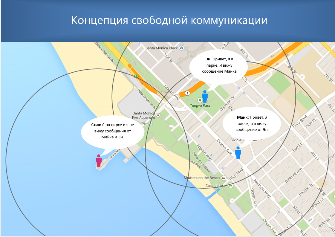
Most importantly, the user should not see messages that go beyond his geographic circle of interests. A user from Moscow is unlikely to want to see messages from Minnesota or Hong Kong. The opposite is also true, in Hong Kong, not many people know about the Moscow Ring Road, and those who know will not tell you whether the congress to Leningradka is worth it now. In short, real topics for communication are geographically limited. But this is not a discovery.
Concept development
It is necessary to limit the range of visibility of messages to a specific zone. Calculate the distance with GPS data is not difficult. Now the application has a radius of visibility of messages equal to about three kilometers. So you don’t see messages from Hong Kong, but Hong Kong doesn’t see yours, but everyone who is within three kilometers of you can see your messages and reply to them. Harmony…
Great, but what's the use of it? There are many options for using the application. Just open the application in a public place and write a message. Anyone who is near you and opens the application will read your message and can respond to you. You can ask for help, and you can post news that is relevant at this time in this place. For example, you came to the store, saw that the cheese was stale, wrote a message. Other people have read it and have not gone to this shop for cottage cheese. And another store saw that people were dissatisfied with the quality of cottage cheese and wrote a message saying that they were fresh to us, we just had fresh cottage cheese, and even cheaper. Ultimately, what information is shared with other people, the user must decide.
Mass communication
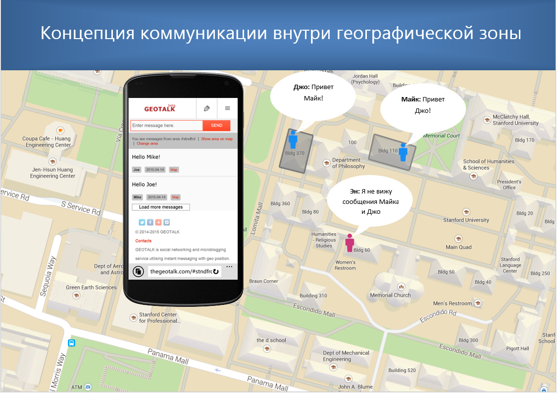
We can limit the area of communication in an arbitrary way and bind such zones to geographical objects. For example, this could be a whole continent, a single country, a city, or even a single house. We simply draw a figure on the map that follows the contours of a geographical object. It remains to obtain the coordinates of the figure and limit the reception and sending of messages for users who are outside the aisles of these coordinates. For example, if you choose your own house as a zone contour, then all devices that are inside the house can exchange messages with each other. At the same time, all devices that are outside your home will not be able to see messages from this zone and respond to them.
Now we can provide an interesting service, the main key of access to which is always your position according to the GPS coordinates. Where this service can be useful, you ask. Here are some of the possible uses:
- Suppose you decide to hold an exhibition or conference, and you want people to communicate there, share news and impressions. You yourself at any time could bring to all participants without exception important information.
- You are the owner of a regular bar and you want visitors to be able to communicate in private virtual chat when they are in your bar.
- at the airport or train station, using this service, it is easy to create a zone for communication and publication of news, emergency and urgent information.
- since it is possible to select not one but several objects in the communication zone, it is easy to combine objects located in different places of the globe. For example, you can combine all McDonalds restaurants around the world into a single communication zone.
Users create zones on their own. Links to zones created by users are implemented as url with a grid. For example, now to get to the Moscow zone, you need to follow the sitename / # moscow link or use the special form in the menu.
About development, monetization and resources
The concept was confirmed, and the results showed that the application can be a very useful tool for people to communicate. Immediately there was an overwhelming desire to translate service into real life. But despite the apparent simplicity of implementation, there are many nuances and issues that we are trying to solve. And one of them is money.
The application itself will be free. The working naming of the application is GEOTALK. We see the following channels of its monetization:
- selling targeted ads that will look like a regular message, but always show up at the top. Also, such messages will have an increased size of the field of view;
- encrypted secure zones for b2b communication;
Due to the mandatory use of the user's geo-position, the effectiveness of advertising is greatly increased. Such advertising is very cheap and at the same time covers only the target audience. For example, if you need to advertise a small beauty salon of regional scale, you do not have inexpensive and effective tools to do it. And GEOTALK is the best way to cope with this task. Those. the GEOTALK application has in its arsenal a unique technology that other applications and websites do not have.
The development of the application requires resources that are currently not enough. Yes, money is needed, but what is more important than any money is people. Technology without people is an empty sound. At this stage, we continue to form a project team.
Application prototype
Application prototype already exists. It is able to do everything that is needed in order to demonstrate conceptual possibilities. And at this stage it is planned to receive investments in the project. You can feel the web prototype now, but in order not to violate the rules of Habr, I can link in a personal.
There is a huge checklist in which ideas are written that I would like to implement in this application. Here I will publish a small part of the tasks from the development plan, which in my opinion are the most important.
Tasks and ideas
From the “Urgent Tasks” list.
From the list of common tasks.
- The service needs a new design, in which all the basic functions will harmoniously fit in, on its basis we will develop an application for ISO and Android.
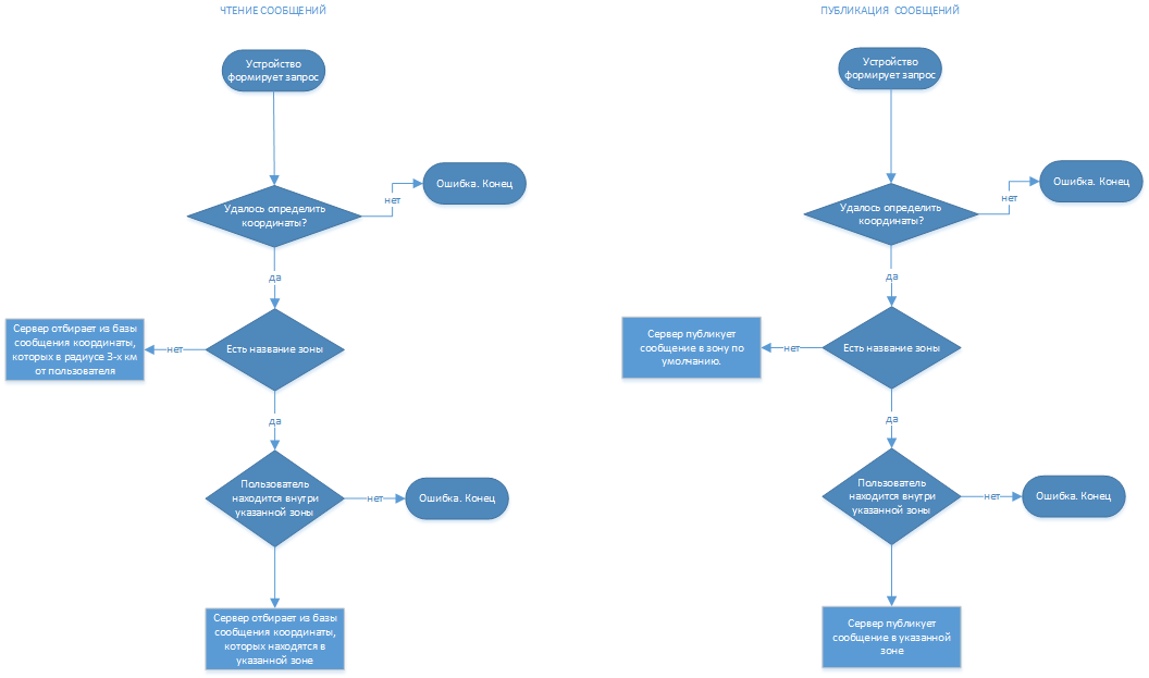
- The service has no concept of working with zones. There is a #nearme zone (radius of 3 km around) into which, by default, any user who visits the site falls. The user can manually change the zone, but so far there is no elaborated formula for how to inform the user about the zones that are around him.
- It would be logical to show the user the zone in which he is at the moment, so that he could go into them and see the messages. For such zones, you need to show a kind of mini-description, so that the user does not enter the zone if the information there does not correspond to his interests.
From the list of common tasks.
- Obviously, a gradation system is needed, i.e. The Moscow zone created by the Moscow government, into which official city news is published, should somehow differ from the exact same zone created by Ivan Ivanov. Accordingly, there is a need to develop a mechanism according to which zones will be ranked.
- It seems that the service should be registered, like all decent social media and pages with user profiles containing at least minimal information. While in question.
- Development of an option that will enable the ability to disable the publication of messages by users who do not have permission to publish. An example of a zone that is responsible for civil defense and emergency situations.
- The mechanism for subscribing to certain zones. Need the ability to customize notifications of new messages.
- Need the possibility of personal correspondence between users, and the system of invitations to the zone.
- Message history and adding messages to favorites.
- Multimedia messaging support. The ability to reply and quote other messages.
- Branding pages of geographic areas. Pages for news agencies
Apotheosis
The opinion of the community, in fact, for the sake of which all this fuss and this article. For us, this service has become an obsession, and we can no longer evaluate some of its sides objectively.
Maybe one of you can cool our ardor and say, “What nafig cottage cheese? What are traffic jams? But who needs it? ”- and will give his arguments.
Or maybe someone is interested in this concept, and we will hear an opinion on how you can still use messages with geo tags.
What are the options for the development of this technology you see?
UPD: it became clear that without a full-scale demonstration the discussion is not substantive, a link to the prototype of thegeotalk.com
Source: https://habr.com/ru/post/274295/
All Articles