Drone dodging probe: Expose the sensation
Foreign media have published information about the project "aerospace probe", which can be used to intercept radio data of various aircraft devices, including drones. Today we will look at the technical side of this project in more detail.
Spy probe
Researchers from the Critical Engineering project described the structure of the Deep Sweep probe in a special document - it consists of a spherical acrylic container with special equipment that rises to a height with the help of a 2.4-meter balloon filled with helium.
')
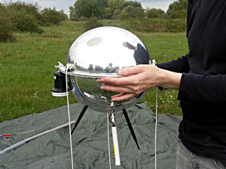
The device also includes three antennas, “listening” frequencies of different ranges, special radio software, a GoPro camera and a GPS module, and various sensors. To integrate all the components used Arduino board, USB hub and Intel Edison minicomputer.
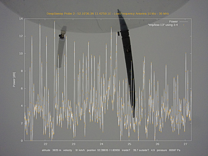
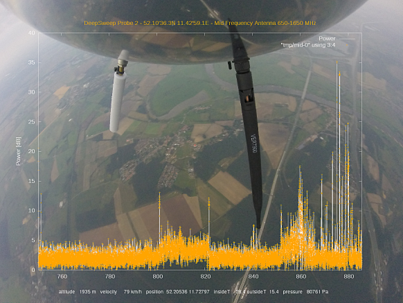
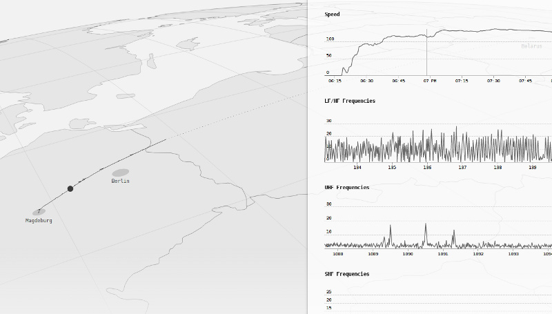
The probe rises to a predetermined height of 24 kilometers and begins to intercept and record the information of the radio traffic, which the researchers analyze after they pick up the device that has landed.
View from the camera probe with superimposed intercepted information
As the researchers themselves say, the goal of their project is to create a new way of collecting data on the operation of high-tech devices flying above the ground and often owned by the state - drones, satellites and high-altitude reconnaissance aircraft.
According to one of the researchers, Julian Oliver, the entire device costs less than $ 300, another $ 200 is spent on the balloon and helium for it.
We wanted to create an inexpensive platform that everyone could use to learn altitude signals. It is good to have an interface for reading signals that are transmitted in the sky above us, this will allow us to understand what is happening.
At the moment, the team has implemented two test launches Deep Sweep:
Upon reaching a given height, the balloon with helium explodes (having previously expanded almost 10 times relative to the initial volume), then the spherical container throws out the parachute and begins to decline. A SIM card is built into the probe and, after landing, it sends an SMS with location information to its creators.
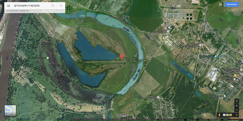
During the tests, not everything goes perfectly - with one of the launches from the territory of Germany, the device landed in Poland. At the same time, his battery was not enough for the entire flight, as a result of which the collected data was lost. Another time, the probe lost the signal of the cellular network and “caught” it only the next morning, however, in general, the flight was deemed successful.
The data collected during the second run are available here , and here their visualization is available.
The researchers plan to create a whole movement of enthusiasts who would be engaged in the collection of such information. In the near future, they will create instructions that standardize the publication of data collected using probes.
According to Oliver, they hope to intercept communications between the special services and the flying devices they use that can engage in espionage. The researcher says that such negotiations without any doubt should be encrypted, so that a simple interception of data will not allow to understand the essence of communications. However, at a minimum, this will allow the detection of such devices and, perhaps, in the future, learn to distinguish between their types.
Not so simple
Despite the enthusiasm of the researchers, they will have to face a large number of intractable problems. Positive Technologies expert Pavel Novikov worked several years ago on a project to launch probes for taking photos and videos into the stratosphere. Below is his story about the difficulties with which such a project is involved.
In Russia, the launch of probes into the stratosphere requires approvals, since this may cause interference to aircraft. It is also impossible to buy freely available meteochars used by weather stations. Expired versions are sold on eBay, which with a high probability may not fly up to the desired height. It was also not possible to launch from meteorological stations - meteorologists refused to give permission for this.
In addition, there are other technical problems - up to a height of 30-40 km, the ball flies for about two hours, and then with a parachute it drops as much again. In 4-5 hours of flight, the probe can fly 30–200 km from the launch point, depending on the wind - at a height it can blow in any direction, so it is impossible to predict the direction of flight. On the ground, a sufficient number of protected and simply private objects, upon landing on which the probe, will not be returned to the owners.
Also, the temperature in the stratosphere can reach -70, and the humidity during the passage of clouds - 100%, which adversely affects the operation of electronics and batteries. At altitudes above 10 km, GPS may not work, you can only pick up a receiver that will do it, by experiment.
Cellular communication is also “not caught” at the height. Therefore, the time window in which the GSM receiver must find the network and manage to send its location is too small - approximately in the interval from a height of 500 meters to 50 metros, then there is a risk of losing the network, for example, falling in the forest.
Also, with a budget of $ 300, most likely a set of three SDR RTL2832 was used, each of which allows you to capture a 3 MHz wide spectrum (a total of 9 MHz). For comparison, the 3G channel has a width of 5 MHz, LTE: 1.4-20 MHz, one TV channel from 5-14 MHz. When using more "serious" SDR, you will need to use Core i7 processors with a drive of several terabytes with the appropriate battery. However, the probe will not be able to lift more than a pair of kilograms.
Satellites fly at an altitude of at least 200 km, geostationary - at an altitude of over 35,000 km, approaching them at 30 km cannot give any advantage in reception.
The satellites also use frequencies from several gigahertz, and more often dozens of gigahertz, due to the characteristics of the atmosphere (megahertz signals reflect the atmosphere, or absorb, while for gigahertz signals it is almost transparent). Thus, such SDRs cannot catch data transmitted by satellites, other than GPS signals (1.57 and 1.2 GHz bands).
Assuming the use of spy drones, they are usually controlled and transmit data by directional antennas, and this probe is unlikely to ever get into the signal beam.
But these are not all problems, many radio systems use FHSS (constant carrier frequency shift) to improve noise immunity, and it is extremely difficult to distinguish such transmission on a recorded piece of spectrum.
There are serious doubts that the authors of the project will succeed in making it massive, we repeat it and achieve some real results. In short, the main difficulties:
- Such launches require complex approvals;
- They are extremely risky (the probability of losing a probe is very high);
- And costly - resources (including temporary) to search for a landed probe may exceed its value;
- There are reasonable doubts about the reality of solving the problem from a technical point of view.
Source: https://habr.com/ru/post/267871/
All Articles