"Boss, write an application for us." Requires software developer and hardware for DJI drones

The Chinese started “vacuuming” first China, and now the whole world, to find brilliant application developers for their drones.
In 2014, immediately after DJI (Chinese Google in the field of droning) presented the development tools package (SDK), the first Olympiad on the development of software for drones was held. The winners received 100,000 yuan (about 900,000 rubles). About the first three places - under the cut.
In 2015, the second Olympiad for programmers started from around the world. We will know its results at the end of the summer.
')
There are several projects that, using the DJI SDK, have released very popular and commercially successful programs for drones.
 If you are a vineyard owner, or you need to increase the flight radius in order to fly across
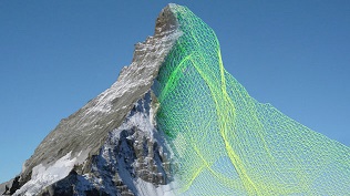
 Or maybe you want to make a 3d scan of Matterhorn (4478m)?
All wishing to write software for the guard-bird, welcome under kat. Otherwise, the Chinese will do it.
Sdk
Drones are stuffed with various features: video cameras, sonars, GPS, range finders, smart batteries, suspensions, telemetry, transmitters, etc.

Support features for different models
SDK supports both IOS and Android

Github

Potential niches for drones and application development

Agriculture and farming, infrastructure control, independent navigation in the absence of GPS, observation and mapping, film making, wildlife observation, rescue and search.
First Olympiad 2014
It was declared 100 teams, 7 reached the final.

Three winners were selected from seven finalists:
First place: BetterW team from South China University of Technology (SCUT)
Second place: White team from Shanghai Normal University (SNU)
Third Place: FlatCat Team from Fudan University
First place
The champions received 100,000 yuan cash. They were offered internships and future employment at DJI.
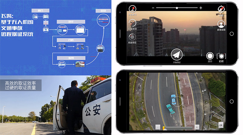
BetterW deserved first place by developing an application that can help with traffic jams caused by accidents. Through the WeChat messenger, a tip arrives at the probable scene of the incident and right there the DJI Phantom 2 Vision + drone is sent there to record the situation. In the future, such applications will be useful to police doctors and rescuers.
Second place
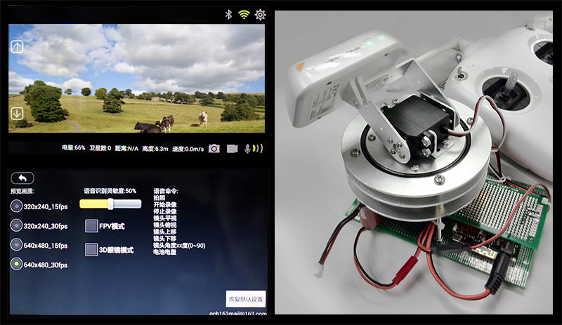
The second place team, White of SNU, impressed the judges by developing a hardware device and a “talking mobile app” that allows the user to take aerial and video recordings. Now the pilot can focus on flight control and at the same time Fota is much easier. The team conducted field tests and maximized the reception area and signal strength, creating a tracking mechanism for the flying device.
Third place
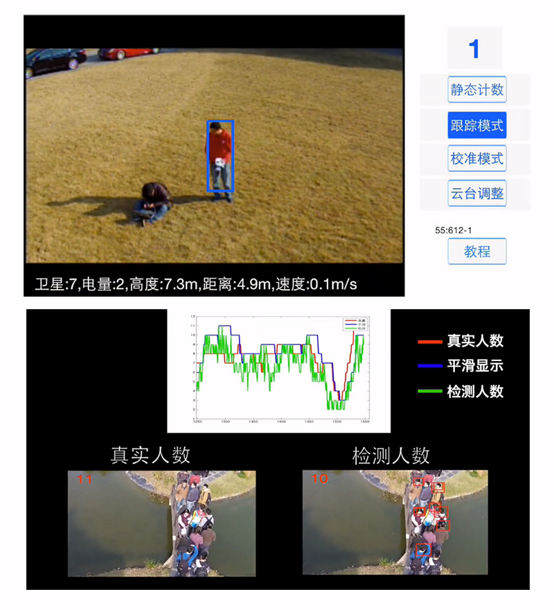
In order to ensure security at rallies and large gatherings of people, the third-place FlatCat team wrote a mobile application that allows drones to take pictures and calculate the number of people in a given territory from a photo. Data can be transmitted to the center for monitoring the flow of people and tracking the movement of an individual.
In addition to the awards for the first three places, there was also the nomination Creative App Awards for outstanding results.
“TIANXING ZHE” - created a mobile application that uses the smartphone's accelerometer to control the flight
“FEIJIZHIMENG” - using a Wi-Fi range extender (Wi-Fi range extender), wrote a program dividing the control into 2 monitors (“remote”), one for flight control, the second for camera control.
“XINGKONG ZHE” - presented a program for aero-self, which makes 360-degree images of the pilot and with the function of tracking individuals into the bargain.
Team For the Dream (FTD) presented an application that makes the flight of the drone more secure using the obstacle avoidance algorithm.
(Less than half a year later, DJI introduced these “sketches” into its main products)
Second Olympiad 2015

Under the slogan "Changing Lives and the World" ("Changing Lives & The World"), the competition is open to students and independent programmers from everywhere. Participants will help "show the world the limitless potential of small drones technology."
The team must register and send a short description of the project. DJI will assess which teams are accepted to participate and who will be given technical advice. The jury will consist of experts from the UAV industry, technicians, experienced entrepreneurs, and they will choose the winners.
At the time of this writing, if you believe the schedule, the teams are desperately finishing their project in order to present it to the jury in mid-August.
Overview of successful drone applications
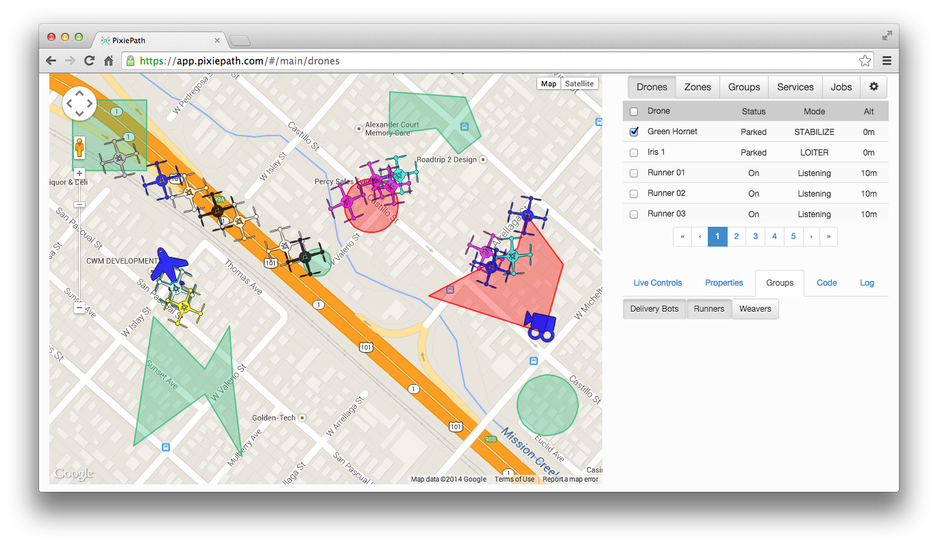
Pixiepath
The application allows you to manage a whole fleet of drones. Possible field of application - search work for lost tourists.
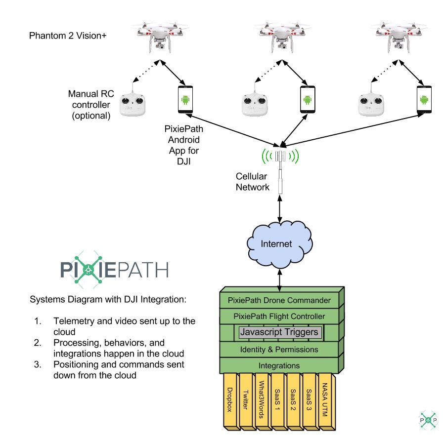
Interview with the project leader
By the way, they need beta testers.
The map, created by a swarm of "candy wrappers", simultaneously flying over the city.
An article in Forbes
Field of view
The company, founded in 2010, provides "soft" and "iron" solutions in the field of cartography for agriculture
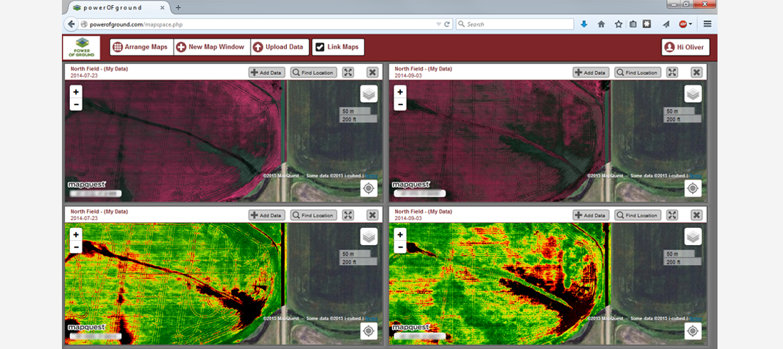
Soft - monitors the health of vegetation

Iron - multispectral and ordinary cameras, specially sharpened for agricultural needs
skyward.io
These comrades thoroughly look to the future, which is teeming with drones and is already engaged in the development of tracks and “traffic rules” for drones.
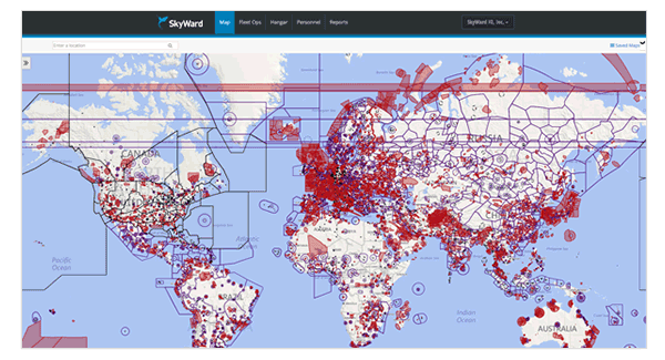
skyward.io/software
Real-time access to various information - weather, traffic jams, etc. The complete analogy with aviation is only for drones.
BrightSky Labs
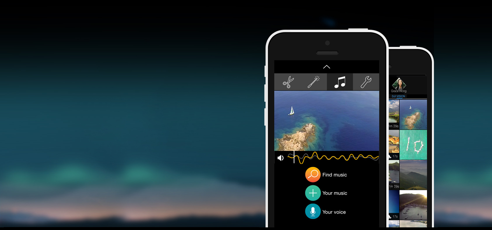
"Instagramma" for candy wrappers. Allows you to post in one click on the social network photos and videos from the drone, putting filters and music.
all features
KEY FEATURES
• Choose the best parts
• Select from stunning filters searched by Hollywood and suggested for your location
• Add your own watermark or title card using top designers
• Add your favorite music or voice to your video.
• Edit your share from your Dropbox with seamless importing.
• Speed your video up to 500% or slowwww it down to 20%
• Share it with Facebook, Instagram, Tumblr, YouTube, WhatsApp, Vine, Path, WeChat, Messages or Mail
• Adjust edits instantly to time constraints where you want to share
• Choose whether to share an awesome high-resolution or higher standard-quality video
• Save your edits directly to your iPhone's or iPad's Camera Roll.
GoPro's WiFi & your DJI Phantom 2 Vision's WiFi?
• Watch out for your video camera.
• Start & stop live recording from GoPro & native DJI Phantom 2 Vision camera
• Control DJI Phantom 2 Vision camera in real time
• Change GoPro camera recording settings
• Record in slo mode with convenient shortcut
• Switch inputs from library to swipe
• Play your goPro or DJI Phantom 2 Vision
• GoPro's microSD card
• Browse files on your DJI Phantom 2 Vision's microSD card
• Share your own favorite parts.
• Enjoy your iPhone or iPad.
• Edit timelapse and slo-mo videos shot with your iPhone or iPad
• Looks epic on iPhone 6 and iPhone 6 Plus - also great on iPhone 5s, 5c, 5, 4s & iPad
• Works great with all GoPro HERO 4, 3+, and 3 cameras
• DJI Phantom 2 Vision and Vision Plus;
Autopilot for Phantom
Drone + smartphone = autopilot and many flight modes, including “follow me”.
Illegal parking
On June 2, DJI and Intel joined forces and created a “city solution” to control parking.
With Intel processors, drones can determine the position and orientation of cars and understand how legally they are parked.
Dronedeploy
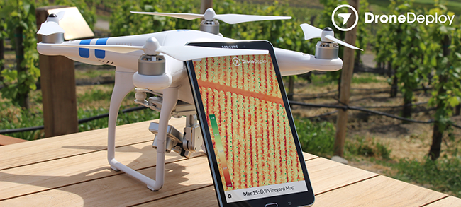
A project for vineyard owners. You can create cards in 1 click. Automatic mapping.
Making maps for the mining industry

You can click here
Creating maps for construction with a resolution of 2cm / pixel
"

Demo
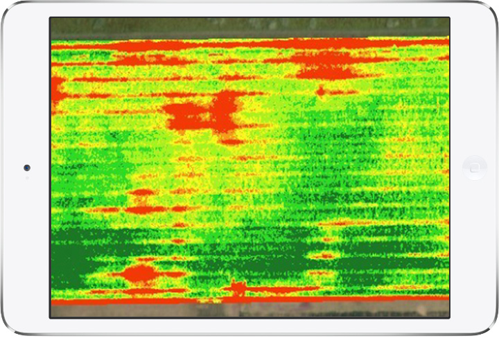
Agriculture - drones will help to find what is unnoticeable to the naked eye - pests, weeds, diseases at an early stage.
Pix4d
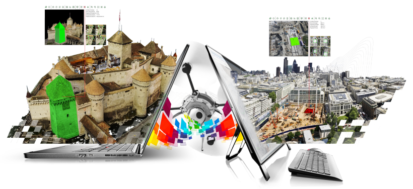
Service for creating 3d-models based on photos taken by drones.
Video channel with training webinars and project reports
The mechanism for creating 3d-models
Information about each photo is recorded in the EXIF file: from which height it was taken, at what angle the camera was turned, which data was longitude and latitude. The program uses computer vision and photogrammetry technology to find common points in many photographs. Taking into account the geo-data and the angle of rotation of the camera, each pixel is searched for a color match in other photos.
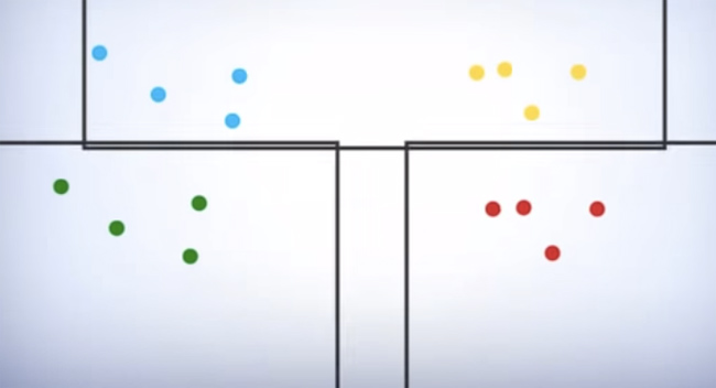
Matching photos
Each match becomes a key point. If the key point is found on three photos and more, the program builds this point in space. The more key points, the easier it is to determine the coordinates of a point in space. Hence the main rule - to maintain a large intersection between photos. Program developers recommends intersection from 60 to 80%.
The spatial coordinates of each point are calculated by triangulation: from each point of the survey to the selected point, a line of sight is automatically drawn (line of sight or ray), and their intersection gives the desired value.

The algorithms used in photogrammetry are aimed at minimizing the sum of the squares of the set of errors, usually solved using the Levenberg-Marquardt algorithm (or the bundle method), which is based on the solution of nonlinear equations using the least squares method.
The collection of all 3d-points is called a point cloud. In the process of processing photos, an expanded point cloud is created, which is used to generate a surface composed of triangles (polygons, meshes). The last step is to calculate the resolution (pixel size) and which pixels in the photo correspond to which mesh. For this, the 3d model is developed into a 2d plane and then the 3d position of the point is matched to the original photo to set the color.
How to turn your drone into a meter
Matching photos
Each match becomes a key point. If the key point is found on three photos and more, the program builds this point in space. The more key points, the easier it is to determine the coordinates of a point in space. Hence the main rule - to maintain a large intersection between photos. Program developers recommends intersection from 60 to 80%.
The spatial coordinates of each point are calculated by triangulation: from each point of the survey to the selected point, a line of sight is automatically drawn (line of sight or ray), and their intersection gives the desired value.
The algorithms used in photogrammetry are aimed at minimizing the sum of the squares of the set of errors, usually solved using the Levenberg-Marquardt algorithm (or the bundle method), which is based on the solution of nonlinear equations using the least squares method.
The collection of all 3d-points is called a point cloud. In the process of processing photos, an expanded point cloud is created, which is used to generate a surface composed of triangles (polygons, meshes). The last step is to calculate the resolution (pixel size) and which pixels in the photo correspond to which mesh. For this, the 3d model is developed into a 2d plane and then the 3d position of the point is matched to the original photo to set the color.
How to turn your drone into a meter
Rio
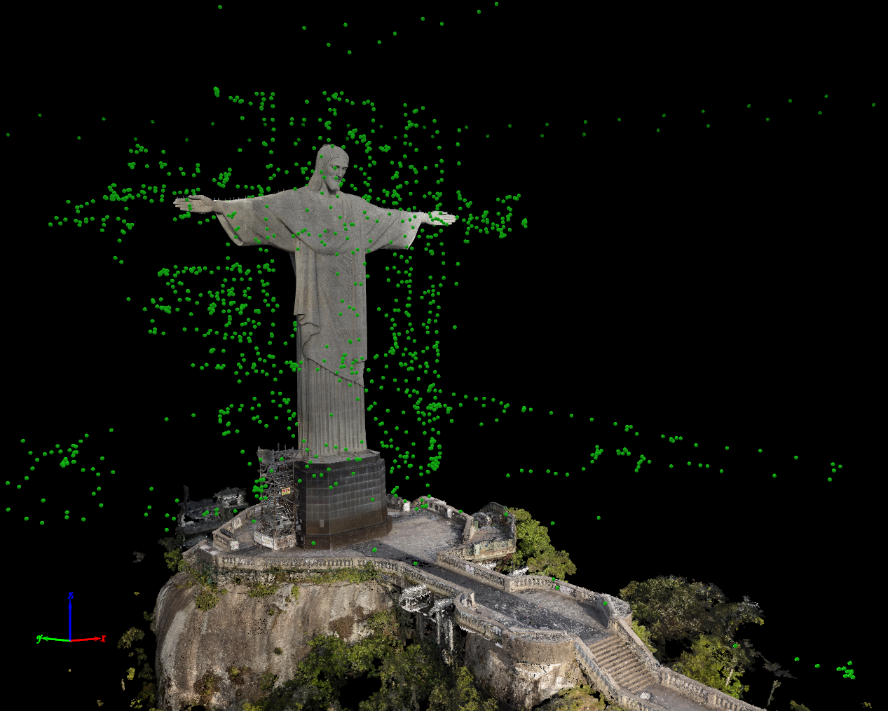
Over 19 ten-minute sorties, 3584 photographs were taken, of which 2090 were used to create the model. Due to strong winds, naughty weather conditions, unstable light and limited hours to visit, the shooting process took about 8 hours, stretched for 7 days. Different parts of the model were manually combined using 82 control points and several length measurements for the correct scale. The final version contains 2.5 million meshes and 134.4 million pixels in a resolution of 16384x16384 pixels.

3D model can be rotated here .
Watch the video how the project was created.
River and flood

for an hour of shooting and 14 hours of processing I was able to get a 3d model of the flooded area with a total area of 360 hectares and a length of 15 km. The accuracy of the model was 4.12 cm / pixel, 1992 photos are combined. The project had two goals: to establish the maximum level of water increase in the river during the flood and to monitor the dynamics in the long term, and to identify areas with fallen trees and find those that affected the coastal flow or formed dams.
Mountain

For 11 sorties on a glider, totaling 5 hours and 40 minutes of flight time, the pix4d team took 2188 photos to create a 3d model of the most famous mountain in Switzerland. The total coverage area was 28 square meters. km, path length is 263.6 km, and the maximum height is 4707 m. The model contains 300 million points with a resolution of 20 cm / pixel.
Castle

The aim of the project was to create a very accurate model of Chillon Castle in Switzerland - a complex architectural structure that includes a courtyard and 18 rooms. Phantom 2 Vision, GoPro Hero 3+, Canon 6D and Sony alpha 7r were used to capture photos of the external and internal parts of the castle.

For half a day the project team took 6200 photos. For the exact reconstruction of the facades, several types of surveys were used: vertically down, camera tilting and ground photos - and then 19 separate sets of photos were processed in the pix4d program, combined and converted into a height map consisting of 95 million points with a resulting resolution of 5 mm to 20 cm
3D model can be rotated here .
Project Report (PDF)
Project video report
For (Moscow) developers
Developers are already needed in huge quantities. I can advise those who decided to start programming
If you can't wait to test your software for drones, CopterTime is ready to provide for the test (on the workshop territory by prior arrangement) a DJI Matrice 100 super-enhanced platform and these models (table with lists of features that are supported in the SDK):
 Phantom 2 Vision + |  Inspire 1 |  Phantom 3 Professional |  Phantom 3 Advanced | |
 | 480p | 720p | 720p | 720p |
 | 1080P 30 fps 14 MP Photos | 4K, 30 fps 12 MP Photos Exposure Modes: Programmed Exposure, Spot Metering, Shutter Priority, Manual Exposure | 4K, 30 fps 12 MP Photos Exposure Modes: Programmed Exposure, Spot Metering, Shutter Priority, Manual Exposure | 1080P, 60 fps 12 MP Photos Exposure Modes: Programmed Exposure, Spot Metering, Shutter Priority, Manual Exposure |
 | √ | Landing gear control | √ | √ |
 | √ | Full 360˚ gimbal control Yaw-axis can be automatically returned to the center position | √ | √ |
 | √ | √ | √ | √ |
 | Gather information from the range extender and datalink Transmission Distance: FCC: 800m CE: 400m | - | - | - |
 | - | Supports channel selection and live stream settings Transmission Distance: 2000m | Supports channel selection and live stream settings Transmission Distance: 2000m | Supports channel selection and live stream settings Transmission Distance: 2000m |
 | - | Master / Slave Mode Embedded gps | √ | √ |
 | Waypoint Joystick Attitude Control | Point of Interest, Follow Me, Waypoint, IOC | Point of Interest, Follow Me, Waypoint, IOC | Point of Interest, Follow Me, Waypoint, IOC |
Source: https://habr.com/ru/post/259527/
All Articles