Google Maps History
Recently, we wrote that, despite the abundance of existing map services, we had to create our own . Of course, we carefully evaluated the functionality of the systems available at that time. We did not ignore the world's most popular map service in the world, Google Maps. It turned out that he was 10 years old this year. And we want to pay tribute to this project, having made for you a translation of the story about the history of the formation of Google Maps.
When the service was just launched in February 2005, it looked like just a paper atlas, only without having to turn the pages. Unlike the printable list of routes, as was done by the then cartographic leader MapQuest, routes here are superimposed directly on top of the map. Loading map image elements took place in the browser, without any special software, so you could explore the world without refreshing the page. It was an unprecedented breakthrough at the time.
In 2005, no one yet imagined what the development of online mapping services would lead to, what invaluable value they would play in the Internet ecosystem. Nobody expected that Google would enter into a partnership agreement with Apple to promote its service on a mobile platform, but this alliance would fall apart. It has never occurred to anyone that Google Maps will be used by more than a billion people, and the service will turn into the second largest project after the search engine.
')
Attendance spike
Service were going to open for general access the next day. At the same time, the authors of the project planned to leave it in beta status. But one of the users calculated the exact address of the page and published it in one of the sections on the Slashdot forum .
Visitors were extremely surprised by the new, incredible features, including scrolling the map with the mouse cursor. Vetka began to quickly fill with rave reviews. However, users immediately pointed out the important lack of service: it contained only the USA map, even Canada and Mexico were shown schematically. The rest of the world was ... an endless ocean.

This planetary ocean hinted at Google’s arrogant and ridiculous ambitions to create a map of the world. And these ambitions expanded even more after satellite images and street photos were added to the service. In the end, the company got rid of the dictates of data providers by breaking direct contracts with countries, states, and even cities around the world.
Almost useless service
From the very beginning, Google promoted the concept of "place" on the Internet. You may not like the way the company displays some of the disputed territories, or some interface solutions, but Google Maps has actually shaped the idea of modern map services, both in terms of interface and functionality. Although, I must say, Google was not a pioneer. In fact, their service entered the market late, the competitors had gone far enough by then.
It all started in the early 2000s. In September 2003, the product was launched with the simple name "Search by location", it was part of the experimental project of Google Labs. This service can be considered the first attempt of the company in the field of cartography. It was necessary to enter some keyword, address or zip code, and Google found the sites where this information was mentioned. True, the service was practically useless, according to the developers themselves.
In support of this, an example is given: suppose you had to find coffee shops in Palo Alto. But Sun Microsystems, for example, placed its address at the end of each of its web pages, and the names of its products were related to coffee (the most famous is Java). And it ruined the whole idea of service. Attendance was zero. Despite the fact that the information from the database was licensed from the Yellow Pages, the project did not meet the expectations of many Google employees, including Larry Page.
Therefore, the company began to seek inspiration and talent on the side. Shortly before Google went public in 2004, three small companies were acquired: Keyhole, Where2 and Zipdash. The first was the largest of them, although the value of the transaction was never announced. By the time Keyhole existed for 3 years, it consisted of 30 employees and sold for $ 69.95 a Windows application containing satellite images. The key idea was that at first the images were “glued together” with each other to get a solid map of the world, and then it was cut into millions of squares. Therefore, users could start browsing from a large scale, and then "approach" to selected places on the surface of the planet. Just this opportunity was so impressed by the top management of Google, headed by Sergey Brin, that they decided to buy Keyhole.
True, it was not easy, the company had enough financial capacity to maintain independence. However, as a result, the prospect has outweighed the creation of a large-scale map service that can be used in a variety of situations. Keyhole management was interested in the opportunity to give a free and powerful tool to many professionals who need accurate and up-to-date maps. Also, do not forget that it was April 2003, the United States invaded Iraq, and therefore the use of the map service by the military was discussed.
Barely had time
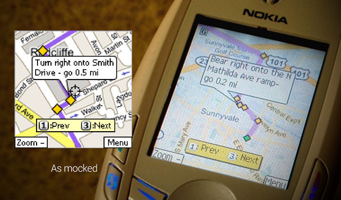
Where2 Technologies was a small startup that almost went bankrupt shortly before it was acquired by Google. At that time, the vision of map services was formed by the MapQuest project, which, roughly speaking, was a list of directions with small map pieces for each turn and intersection. The founders of Where2, the Rasmussen brothers, the Danes, had the idea of creating a full-fledged online map with the ability to move and scale. But no one wanted to buy such a product. As one of the brothers remembers, many believed that the average person would need a map, on the strength of several times a week. And today, many people are literally lost if they do not use online maps several times a day.

Lars Rasmussen (Lars Rasmussen).
The situation for Where2 became critical when one of the venture capital investment companies, Sequoia, unexpectedly refused to finance a startup after Yahoo Maps had integrated the Yellow Pages database into its service. Information about this quickly spread throughout the market, and the Danes began to massively refuse everything. It was just at the time when the dot-com bubble was blown away.
The brothers were broken. Due to visa restrictions, the company was created by them together with two engineers in Australia, and without funding the startup was doomed. However, Rasmussenam incredibly lucky. Sequoia introduced them to Larry Page. Google has not yet had its own map service, but Paget believed that the future belongs to the Internet. Therefore, three weeks after they met, Where2 proposed the concept of transforming its application into a web service that loaded data in the background and did not require a page refresh.
“We were very motivated, either pan or lost. For three weeks we worked day and night, and, as a result, we created a website specifically to impress Larry and his team, ”says Lars Rasmussen, who today works on Facebook. “We even put a Google logo on it. And they used lava lamps as markers on the map, because Google liked them then. ”
It is curious that at the same time, the development team inside Google implemented exactly the same concept for the first version of Gmail. However, they were not familiar with the ideas of Where2, and, as a result, created a fundamental web technology that today is known as AJAX.
Third musketeer
In 2004, a small Zipdash startup consisting of three people (even not a startup at all, because they did not register a legal entity), developed a mobile application to obtain information about road congestion. In fact, the work was just begun, the first version of the product was made for Nextel phones. The founder of Zipdash, Mark Cradi, has invested thousands of dollars from his own funds in licensing information about taxi movements around the San Francisco Bay. This made it possible to make a baseline estimate of the current road congestion, and with an increase in the number of Zipdash users it would be possible to increase the accuracy of the estimate.
The idea was similar to Waze, a peering mapping application that Google acquired in 2013 for one billion dollars. And Zipdash was bought for just two million. True, Google was far from being rich at that time, because it had not yet carried out an IPO. However, the scale of the two companies was incomparable: at the time of the acquisition, Zipdash had a customer base of ... 200-300 people.

Mark Crady.
So, Zipdash joined Google, and his team began working on a product that later turned into a mobile version of Google Maps. And, of course, no one imagined that, compared with the online Google Maps (Where2) and Google Earth (Keyhole), the mobile version of the service from the tiny Zipdash will turn into one of the largest projects of the company. In 2009, Crady left Google and is now working on his new project.
Google life
When the three companies described above joined Google, their employees continued to work on their products, but within the framework of the vision of their new employer. They were allowed to entice new members within the company. For example, the Rasmussen brothers as one of the advantages of working in their team called ... Danish cookies.
So, the work has begun. The Where2 team stuffed a bunch of computers into their room, where the tiles that make up the map were rendered. Jens Rasmussen proposed the idea of introducing the famous Google pins (pins) as opposed to the red stars in Yahoo Maps. The advantage of this designation was that the pin indicated with its sharp corner a place on the map without overlapping it with itself. Jens wanted to achieve the effect of three-dimensional pins, although in fact they are not three-dimensional.
At the same time, John Hanke (John Hanke) from Keyhole began to carefully work out a request for an increase in the resolution of satellite images, since this was very expensive. John wanted to start with the big cities. He prepared a large presentation on the cost structure for Page, Brin and Eric Schmidt. At the end of the presentation, Bryn asked: “Why don’t we just do all this?” Hanke says he was shocked at that moment, but Bryn was serious. Increasing the resolution of images cost Google many millions of dollars, and the company specifically created a high-speed communication channel to receive such volumes of traffic from a supplier from Colorado. But so far, the level of ambition Google exceeded the interest shown by users to their service.
Growth
Initially, Google Maps and Google Maps Mobile services had low traffic. This is all the more surprising against the background of their current demand. When the link to Google Maps was placed on Slashdot, the traffic just went through the roof. In these early days, it reached 10 million views.
However, then the traffic quickly fell. And almost a year passed before he reached the initial level again. The development team was confident that their product was the best on the market, and users agreed with them, but for some reason did not rush to use the service.
In the end, to achieve an unprecedented increase in attendance was due to two things. First, satellite images from Keyhole were added to Google Maps, and now anyone could see their home from a bird's-eye view. And secondly, the client part was completely rewritten in order to increase productivity, and besides, a package of tools for developers was released, which allowed third-party companies to use the Google service at the heart of their products, thereby promoting it.
Since then, traffic growth has not stopped. By the end of 2006, less than two years after launch, Google Maps has become the largest mapping service in the world. And soon, in terms of traffic volume, it became the second Google project after www.google.com .
Something similar happened with Google Maps Mobile. The first version was available only for several phone models and did not allow to see the current road congestion. The number of installations was small, and those who installed the program did not use it too much. The situation changed for the better only after support for BlackBerry phones was added.
But even then, there were people at Google who did not see the potential of this project. Of course, this is a long time in the past.
In January 2006, Yahoo launched a product called Yahoo Go, in which many previously disparate services of the company were combined: a search engine, a news resource, a postal service, a weather forecast, and traffic information. Crady agrees with Schmidt that the GM mobile development team will create a worthy response product. From this day there was only talk about the need to create a completely killer application.
Apple deal
Today it is obvious to everyone that mobile cards are the most killer app. Once your smartphone knows where it is located, then you can go wherever you look, find a nearby institution, go around the traffic jam and do not care about taxi drivers.
And it's not just Google Maps. Over the past decade, several products of similar quality and functionality from Baidu, Microsoft, Yahoo and Apple have appeared. But 10 years ago nothing like this existed.
The default arrangement on all iPhones was a huge success for GM. However, the difficult relationship between the two companies began long before Apple launched its map service in 2012.
Even before the launch of the first iPhone in 2007, Apple secretly agreed to work with Google. Apple wanted to ship their phones with the application preinstalled, and for this they needed the help of Google. However, Apple did not allow developing the interface on its own; they agreed only to load their data. In the conditions of the highest secrecy, the companies jointly developed an application for the first Apple smartphone.
From the very beginning, the two corporate cultures had little in common. But most of all, Apple was unhappy with Google’s work on Android. Jobs began to put forward various demands, including a ban on using double tapes to zoom the map. In addition, Apple refused to share statistics on user activity with Google, as a result, the company was forced to generate a roadmap without the participation of a huge proportion of users.
The list of requirements was getting longer. It was originally planned that Google will be the exclusive supplier of maps for the iPhone. But then Apple decided to negotiate a deal to allow third parties. Google again requested statistics on user activity, and again was refused.
According to Mark Cradi, looking back it becomes clear that even Steve Jobs, despite his incredible flair, could not foresee the future development of mobile cartography. In fairness, it must be said that, given such long friction between companies, Google had to plan B for a long time in case Apple refused to cooperate. But when it finally happened in 2012, the company was taken by surprise and spent three months thinking what to do next.
View from the street
In 2007, Google hired a Stanford research team that did three-dimensional scanning of the statue of David by Michelangelo. In addition, the startup VuTool, founded by a professor at the same university, Sebastian Thrun, was acquired. The startup dealt with the problem of visualizing data taken with the help of external cameras installed on cars. New employees were combined with those who voluntarily volunteered to spend their “experimental 20% of the time” on a project that eventually became part of GM - Street View.

Luc Vincent.
One of the "volunteers" was Luke Vincent, technical director of Google. At that time, he had been with the company for more than ten years and was on the Google Books development group. According to Luke, at the beginning of work on Street View, the development team bought several used Chevy Astrovan, about $ 5,000 each.
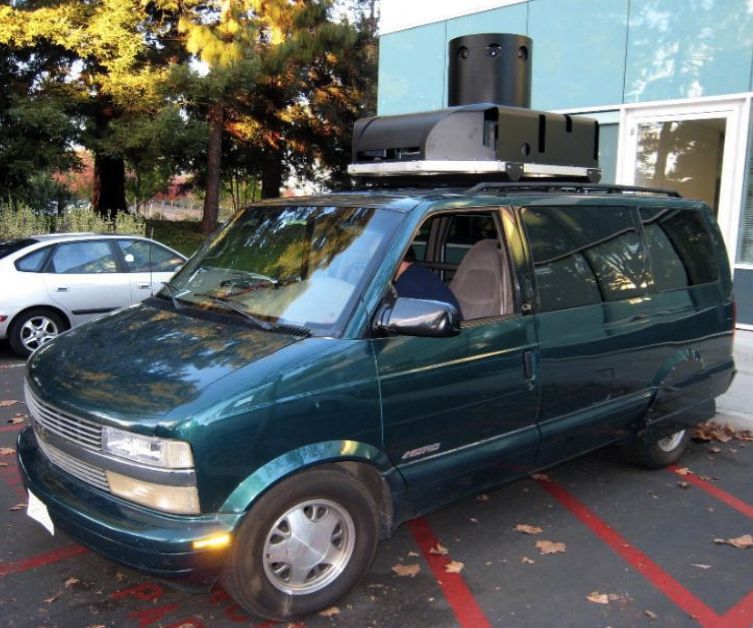
The vehicles were filled with equipment and cruised along the Mountain View and Palo Alto, taking pictures of the streets. We drove very slowly to reduce the effects of vibration. Among other things, the cars were equipped with laser systems, which featured the bright SICK brand.
Jokes, but thanks to Street View, the Google Maps project was regularly attacked by privacy advocates. Years later, it will be discovered that one of Google’s engineers used Street View machines to intercept Wi-Fi traffic and redirect to Google’s servers. For this, the company was subjected to severe criticism in several countries.
In addition, many people did not want their houses to be shown on satellite imagery. And now they are also photographed on the street. Under public pressure, Google introduced the practice of blurring all car license plates and pedestrian faces in Street View images. And because of the incident with the Wi-Fi service has been banned in several countries, including Germany.
But, nevertheless, Street View withstood all the shots, and now it is available in all versions of Google Maps in 65 countries. The pictures taken by the machines periodically help to create and correct GM maps. With the help of machine learning, Google can now very accurately show buildings, traffic signs, traffic patterns and building numbers on images.
Ground truth
The latest episode from the biography of Google Maps has been kept secret for many years. In 2007, there were two multi-billion dollar acquisitions: TomTom bought Tele Atlas, and Nokia bought Navteq. Unexpectedly for Google, the two largest providers of cartographic information have changed owners. And not the fact that the new owners will be friendly. The company decided to do something.
A specially created group of developers began to study what kind of data new owners might need to create their own map services, who owns such data and, more importantly, who is ready to sell it. In many cases, Google had to analyze the situation across individual cities. They called it the Ground Truth.
During the work of this analytical group, it was found out that the Ground Truth project can help Google not only get rid of archaic licensing agreements once created for CD-ROMs and embedded car navigators, but also develop new services, such as cycling and walking routes.
And Google decided to do this. It was a well thought out decision. If you start to create a map of the world, you can never stop. After all, the world is constantly changing, and in some cases it becomes a real challenge for the company, because in this case you cannot just try and change your mind.
An international team of 20 specialists worked on the collection of cartographic data. Sebastian Tran led the creation of tools and services designed to integrate all types of data. A large group of programmers from India helped in this work.
When the first line was completed and a map of the United States was created, letters were sent to Google employees asking them to test the map where they live, especially in the places where they grew up.
Epilogue
This ends the early history of Google Maps. Today, many of those who created the main components of this service either don’t work for Google or switch to other projects. For example, Luke Vincent continues to be engaged in image processing, but this is already data from two satellites, which Google received after the acquisition of Skybox for $ 500 million in June 2014.
Today, the division of geo-information services is one of the key divisions of Google. The Ground Truth project is still working to keep company cards up to date. New third-party companies and startups are being acquired, such as Zagat, Waze and Skybox. Street View added pictures of the Grand Canyon and the canals of Venice. And Google Maps became the basis for one of the most ambitious projects of the corporation - robotic cars.
Source: https://habr.com/ru/post/253863/
All Articles