Yandex.Maps, 2GIS or still Google Maps?
#ifndef MY_HABRA_ENTRY #define MY_HABRA_ENTRY Peace to you, dear habraiser!
Minute revelations. I don’t prevaricate, I will reveal the veil of secrecy that I have wiped my leather chair, fidgeting on it, and wondering whether it is worth writing it all. Doubts overpowered me to the last, but someone sitting on the right shoulder still defeated someone on the left. And voila, many letters in front of you. I want to admit something else at once: the main purpose of writing this article is, first and foremost, to satisfy one’s personal needs, ambitions, and maybe even the point of self-realization, which was still not enough to complete the process of reaching the top of the evolutionary ladder ...
Minute lyrics. I need a constructive (I adore this word! And it is in all this key) criticism of the professional community, that is, you. Otherwise, I may begin to paranoia from obsessive thoughts that maybe somewhere in this life I turned the wrong way ...
')
Minute
In general, if it is short, an article about the comparison of geo-information services, the leaders of the Russian market.

Next will go slightly modified text in the form of answers to questions from the very test task of one company from this. Headline I remind you why I still want you to read this: try to refrain from reprimanding me as a person or company that refused me. I want to leave all the intrigues aside. I ask for the opinion: what, in your opinion, is not so in the answers. Of course, I would be very happy if this article is useful to someone, even more if it is for applicants. All good!
char *company_names[] = {".", "2", "Google Maps"}; char *COMPANY = company_name[rnd.next(3)]; 1. Describe the main scenarios for the use of cartographic and reference information, give examples. Indicate scenarios in descending order of audience.
Audiences for each use case vary by region. For example, in Moscow, a huge number of organizations. They open, close, move. The overwhelming number of places belong to the category "where you have to go only once." Therefore, in systems that provide cartographic and reference information, users in Moscow use navigation more often than search services. In the regions, the situation is reversed. Users know the city well enough and more often look for services rather than a specific address.
To better understand the basic usage scenarios, I have compiled a Use-case diagram:
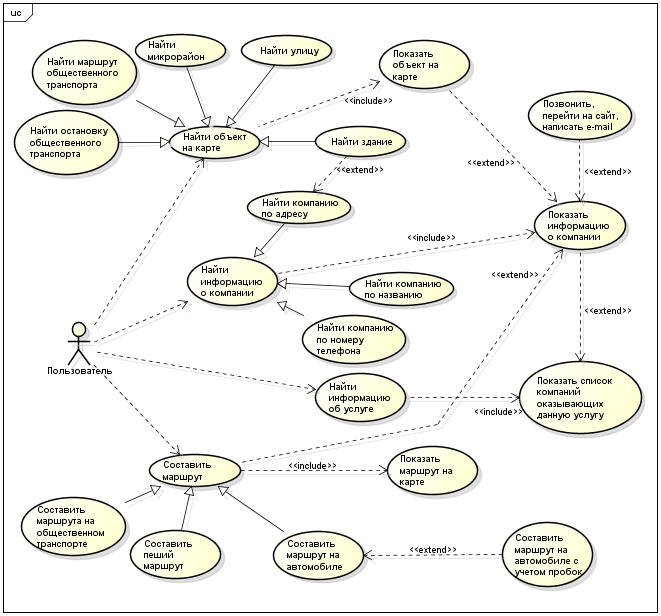
Find an object on the map.
Short description. This use case describes the search by the user of the desired object on the map.
1. The main flow of events.
This use case begins when the user wants to find an object on the map.
The system requests known information about the object.
The user enters information about the object: street name, address, district name, public transport stop name, public transport route.
At the time of entering information, the application displays prompts.
After entering the information, the user clicks the "Find" button.
The system searches for this object on the map, and then displays it.
2. Alternative streams
2.1. Property information not found. If during the execution of the Main thread it is found that the user has entered information that is not in the database or by which the object cannot be determined, the system will notify about it. The user can return to the beginning of the Main stream or abandon the search, and the use case ends.
2.2. The user used the hint. If during the execution of the Main thread it is found that the user has selected one of the suggested hint options, the system inserts the corresponding information from the hint in the input field. The user can return to the beginning of the Main stream or continue the search, for this he needs to click the "Find" button, while the use case continues.
3. Preconditions
None.
4. Postconditions
If the use case is successful, the user sees the requested object on the map. Otherwise, the state of the system does not change.
Find information about the company.
Short description. This use case allows the user to find detailed information about the company.
1. The main flow of events
This use case begins when the user wants to find information about the company.
The system asks for known company information.
The user enters information about the company, such as company name, telephone number.
At the time of entering information, the application displays prompts.
After entering the information, the user clicks the "Find" button.
The system searches for a company based on the information entered, and then displays the full information about the company.
2. Alternative streams
2.1. Company information not found. If during the execution of the Mainstream it is found that the user has entered information that is not in the database or which cannot identify a company, the system informs about it. The user can return to the beginning of the Main stream or abandon the search, and the use case ends.
2.2. The user used the hint. If during the execution of the Main thread it is found that the user has selected one of the suggested hint options, the system inserts the corresponding information from the hint in the input field. The user can return to the beginning of the Main stream or continue the search, for this he needs to click the "Find" button, while the use case continues.
3. Preconditions
None.
4. Postconditions
If the use case is successful, the user sees detailed information about the company. Otherwise, the state of the system does not change.
Find information about the service.
Short description. This use case describes the search by the user of the company providing the necessary service.
1. The main flow of events.
This use case begins when the user wants to find a company that provides the necessary service.
The system prompts you to select a service from the directory or enter it in the search field manually.
The user enters information or selects from the directory.
At the time of entering information, the application filters the directory based on the information entered by the user.
After entering the information, the user clicks the "Find" button.
The system displays a list of organizations providing this service.
2. Alternative streams
2.1. Service information not found. If during the execution of the Mainstream it is found that the user has entered information that is not in the database or which cannot be identified by the company, the system informs about it. The user can return to the beginning of the Main stream or abandon the search, and the use case ends.
3. Preconditions
None.
4. Postconditions
If the use case is successful, the user sees a list of companies providing the requested service. Otherwise, the state of the system does not change.
Make a route
Short description. This use case allows the user to create a route.
1. The main flow of events
This use case starts when the user wants to create a route.
The system asks for the starting and ending point of the route.
The user enters the name of the stop or indicates a place on the map.
At the moment of entering the name, the application displays hints or suggests using the current location.
The system suggests choosing how to build a route: “Create a route by public transport”, “Create a walking route”, “Create a route by car”.
After entering the start and end point, the user presses the “Build route” button.
The system builds a route, and then displays it.
2. Alternative streams
2.1. Stop not found. If during the execution of the Main thread it is found that the user has entered the name of the stop, which is not in the database, the system informs about it. The user can return to the beginning of the Main stream or refuse to build a route, and the use case ends.
2.2. The user used the hint. If during the execution of the Mainstream it is found that the user has selected one of the suggested hint options, the system inserts the full company name in the input field. The user can return to the beginning of the Main stream or continue the search, for this he needs to click the "Find" button, while the use case continues.
2.3. Several routes. If during the Mainstream it is found that the system has proposed several routes, the user has the opportunity to select a route from the proposed ones, after which the system will display it on the map.
3. Preconditions
None.
4. Postconditions
If the use case is successful, the user sees the constructed route. Otherwise, the state of the system does not change.
2. What services are competitors of COMPANY? What are their strengths and what are the advantages of COMPANY? What are the key success factors in this market?
In the Russian market of mapping and reference services, there are three main players:
- Yandex maps;
- 2 GIS;
- Google Maps.
Yandex.Maps and Google Maps services were created as services that provide cartographic information. 2GIS initially provided the user with background information about various organizations in the city. In the future, these services have evolved to a full-fledged reference and navigation products, combining many features and services of city navigation.
part of the text is missing
In the table below, a comparison of products according to competing criteria.none
| Yandex maps | 2 GIS | Google maps | |
|---|---|---|---|
| Coating | The best coverage of Russia, inferior to Google in the coverage of the world | Losing to competitors in coverage both in Russia and in other countries | The best coverage of the whole world |
| Good detail of Russia, sufficient in the world | One of the best details in the cities of presence | Good detail around the world. On the map of Russia may not be large cities. In terms of display vague detail. Objects are clearly visible only with a fairly strong approximation. | |
| Building level detail | Not | Large shopping centers | Large shopping centers |
| Ability to download and use offline | Yes. Large data size | Yes | Yes. Large data size |
| Service "People's Card" (web); Error message | Error message | Error message | |
| The option to select the display of the landscape | Map, satellite, folk map | Map | Map, satellite, velokarta, public transport |
| Yes. Display additional traffic information | Not all cities | Not all cities. Integration with the Waze service | |
| The possibility of communication between users | "Talkers" | Not | Not |
| Street View Overviews (Streetview) | Yandex Panorama | Not | Google streetview |
| Yes. Smart Search | Yes | Yes. Smart Search | |
| Voice input (in Russian) | Yes | Not | Yes |
| 3D mode | (*) Uniform building height | Yes | Yes |
| Night mode | Yes | Not | Yes |
| Building a route | Car, public transport. Builds in view of traffic jams. Requires internet to build | Car, public transport. Ability to select the option "Metro". Does not require the Internet to build a route | Car, public transport, walking route. Opportunity to choose only one of the types of transport or option on foot. It builds in view of traffic jams and public transport schedules. Requires internet to build |
| reference Information | Detailed information about organizations | Detailed information about organizations. Monthly updates | Russian organizations know worse than others |
| Geo-reference information update | No information | Updates every month | No information |
| Ability to leave feedback and evaluate the organization | Evaluation. The Yandex.City service is developing. | Integration with Flamp service | Review and rating |
| Interface and Usability | Modern interface. Most functions are possible in two steps. | IPhone interface version is not adapted for iOS 7 | Modern interface. Some features are not fully understood at the intuitive level. |
| Total: | He knows well the geography and organizations throughout Russia. Availability of services "People's Card", "Street Panoramas", voice input | Detailed information on organizations and highly detailed maps in the cities of presence | Convenient and functional building routes. Street panorama, voice input |
Success factors:
- Necessary and sufficient functionality for the implementation of full urban navigation.
- Availability of products for different mobile platforms ( iPhone and Android versions are required).
- Intuitive interface, following the trends in design.
- Access up-to-date reference information with constant updates.
- Ability to work offline, it is desirable to use for this a small amount of memory.
3. How do you think you can develop a product development strategy for 6-12 months in advance? How will you make decisions - which opportunities to implement and which not?
First you need to identify trends in this area. Analyze where competitors are moving. For example, for the COMPANY product, pay attention to the Competitor1 , which is currently actively developing the Project1 project. It is necessary to plan what will show Competitor1 and Competitor2 in 6-12 months in their products. To compare these data with the objectives of the company, to suggest what can happen when the paths cross. In such regions as Moscow , St. Petersburg , COMPANY clearly lags behind competitors, which means you need to catch up with them. In turn, on the Windows Phone platform, Competitor2 is not officially represented, and in Competitor1 it is not possible to use this product offline.
It is necessary to take into account the factors of the rapid development of telecommunication technologies. Already now you can watch panoramas from your mobile. With the development of technology, mobile phones will be able, for example, to play video tours with high quality. The growth of the productivity of "iron" and the ability of mobile cameras will open new frontiers for the realization of the ideas of augmented reality, the integration of special devices, for example, glasses with a three-dimensional image. For the COMPANY product on the Windows Phone platform , it is necessary to pay attention to the development calendar of this platform. Follow the new tools, frameworks from Microsoft , which will provide access to the use of new technical features.
In general, you need to understand who the target audience is. All improvements and changes in the system should not contradict its interests. The use of such techniques as cohort analysis will be especially useful. In the case of COMPANY, this clause may be the least useful given the large heterogeneity of the potential audience. Development of the community, a platform for discussing the product, conducting surveys and communication between users of the product. Listen and encourage people with enthusiasm, hold quarterly rallies with them, to get feedback.
I think the task to come up with new opportunities for the COMPANY product is not. The stock of features for the development of mapping and reference services is sufficient and is well known to professionals from this field. Technically it is possible to develop in width - add new features, and in depth - develop existing ones. Important here is the choice of the very features that will be implemented within 6-12 months. To do this, it is worth considering the value of the feature, the cost of resources, the experience of competitors, the desire of users. The choice is the result of a discussion of the feature pool with the team. The final decision on the implementation of a specific feature is always taken by the product manager, based on the above factors and on his own sense of the market. In this case, I always take responsibility for myself.
4. Give any examples of a convenient and inconvenient interface. What is the most successful and most unsuccessful in them?
When answering this question, I first of all proceeded from the fact that there is no point in citing "overwritten" examples of good and bad interfaces. These cases are already known to everyone from the Internet and the corresponding books on UI / UX. Therefore, I will give examples from COMPANY products and competitors. For example, in Google Maps ( iPhone version) in pursuit of beauty and minimalism, there is no possibility of using the application with one hand, which does not correspond to today's mobile trends. In Yandex.Maps and 2GIS-e, for the function of zooming in / out the map, it is possible to enable special buttons for the Card Approach / Distance. The tool must first be comfortable, not beautiful.
I consider it successful to display the proposed routes in Yandex.Maps and 2GIS (on the Windows Phone platform). Before you choose a route, the user has the opportunity to see it on the map.
Caution! Screenshot!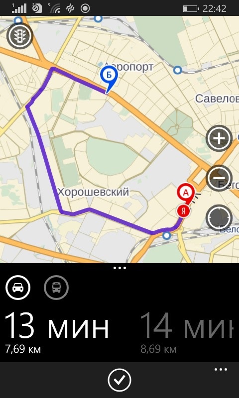
In turn, I consider the unsuccessful interface of 2GIS (on the iPhone , Android platforms ) when moving from search results to search results on a map (“Show on map”) and back. It creates a hierarchical structure, in my opinion, unnecessary tabs, in which you can easily get lost, and use them several times more often is not necessary.
#endif /* MY_HABRA_ENTRY */ Source: https://habr.com/ru/post/242015/
All Articles