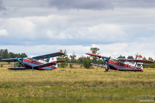
Small aircraft, flying drones, IT and my dream ...
Hello.
I am not an active user of Habr. I comment almost nothing. I read it every day, but I do not consider myself experienced enough in the IT sphere to express my opinion. Therefore, I do not have karma and do not seek to earn it.
')
But I have a dream and a hobby.
I am a former pilot. The former - due to an unsuccessful parachute jump. It so happened.
Everything worked out, I retrained and became a good economist, but the dream has remained, just like the understanding that the sky can strictly punish even minor offenses. Over time, I had an idea to make an application for pilots, the main purpose and idea of which is to reduce the risk of emergency situations and help the pilot in a situation of extreme time pressure. Many developments can be useful to those who are engaged in software for flying drones.
Preamble
Safe flight consists of several components.
1. Knowledge of flight theory and flight safety. Flight safety is largely dependent on ground training and an understanding of "process physics," that is, the minimum basic level of theory. To carry out a simple flight there is no need to receive a specialized education. But to learn the basic principles, guidance documents, the experience of other pilots must be mandatory.
In my dream, I would like to realize:
1. Collection of RLE (flight manual) for various types of air assets (VS);
2. Theoretical foundations of the flight section by section - aerodynamics, the theory of aircraft design, meteorology, legislation in aviation, and so on;
3. Online test system for self-assessment of theoretical training.
This is necessary so that any pilot or UAV operator can independently study the necessary minimum of theory and independently control himself.
I tried various options for distance learning and everything that new knowledge could provide - courses, online seminars, webinars, forums, articles, etc. In the aviation environment, distance and independent training is one of the components of a safe flight. If the pilot does not constantly update his knowledge, then many things are forgotten, replaced by the "experience" of both his and his colleagues. This is a dangerous phenomenon. Therefore, in large AKs, various tests, exams and classes are held to maintain an appropriate level of knowledge and skills.
In small aircraft, this issue is supported relatively weakly, since There is no centralized system for monitoring skills and disseminating information. This space can be recovered using the implementation proposed by me.
There are quite successful ready-made solutions that can be optimized for solving the problem of training pilots of small aircraft.
For drone operators:
1. Everything that flies is obliged to comply with the requirements of the legislation of the Russian Federation. Our law does not share the responsibility for the use of airspace too accurately. Therefore, the launch of even a radio-controlled toy without proper legal training can turn into very serious troubles. Study the RF Government Decree dated March 11, 2010 N 138 “On approval of the Federal rules for the use of the airspace of the Russian Federation” (with changes and additions).
2. The airspace is divided into “flight zones” with different levels of permits, responsibilities and subordination. You may not know that you are launching a drone in the restricted area. But this does not relieve you of responsibility, and the arrest of a district policeman following a complaint from disgruntled neighbors can result in confiscation of the aircraft and a considerable fine. In my memory, the maximum fine for a short flight rendered by the court was about 200 thousand rubles.
The boundaries of the zones you can see here .
3. Very often, drones use rotor or propellers for flight. And just as often, these drones are broken by inexperienced operators at the very beginning of the flight. To avoid this, read about the principles of flight of large helicopters.
Here you can find various documents on various helicopters and their manuals.
Pay particular attention to the various "flight modes" of helicopters in terms of the vertical and horizontal speeds of the helicopter, depending on the altitude. Match the limitations of real helicopters with the size of your drone, and get a rough idea of the limitations for your drone. When developing algorithms, consider these limitations and the probability of breaking a drone on a planet will be significantly reduced.
On Habré, there was also an article about the creation of a simulator for a copter , which describes an interesting (although, IMHO, not quite true) approach to training before real flights. This approach together with the theory will allow a sufficiently qualitative approach to the skills of successful piloting.
Flight planning
The second significant step in safe flight is preparation for departure. The main mistake - a short flight takes less time to prepare. This is not true! A single flight through a box (around an airfield of about 10 minutes) requires almost the same preparation time as an hour flight. However, purely psychologically, I really want to quit and just fly, because it is “five minutes” ... During the night parachute jump, you can be too lazy to recharge the flashlight, because it burns, even if it is dull ... And it’s better not to know for yourself how it ends up and how many months to spend on recovery. Believe me - the time saved at the stage of preparation for the flight is hundreds, thousands of times less than the time for correcting an error. And this is if the error can be corrected.
What would you like in your dream:
1. An automated system for collecting and analyzing primary information required during the flight phase.
2. The possibility of data exchange between flight participants within the time, conditions, flight route.
3. The possibility of notifying interested persons (colleagues, managers, etc.) about the occurring deviations in the planned data and the actual ones at the moment.
This will give the pilot or drone operator the opportunity to reduce the time and effort to prepare for the flight. The use of software algorithms for the evaluation of flight information will allow the pilot to be warned in advance about possible adverse conditions during the flight, as well as to advise on possible solutions. This will improve flight safety.
For drone operators:
1. Flight planning in the case of piloting a drone is a very important element. Since, in most cases, the drone does not have the ability to make decisions independently, based on self-assessment of the data, the most typical patterns of behavior for a given case are invested in the algorithms of the onboard controller.
A vivid example is the algorithm of returning to the point of departure when communication with the operator is lost. There is also not very much variety in the methods used - returning in a straight line, repeating the route traveled, and, perhaps, everything. However, this is a very small fraction of all possible options. Many of them have already been tested in the "big" aviation and can be used in the development of software for flying drones.
Look at the article about how fast you can ruin a great copter , as well as you can see that in modern and expensive copters, developers are not very actively using the experience of “real aviation”. This is evident even in the example of the interface - in aviation, a practically uniform version of the current information output has been used for a long time.
1.1. [Regular flight. Lost connection. Return “by direct”] Return by direct is possible only if the following conditions are met on the route - safe altitude throughout the route, no dangerous weather events throughout the route, no flight zones with restrictions or prohibitions, no air traffic ( We do not forget that when the connection is lost, the drone returns independently and the operator does not have the opportunity to notify other participants of the flights about a possible dangerous approach, and the drone itself does not have the ability to avoid collisions I or notify your route).
1.2. [Regular flight. Lost connection. Return of the route traveled] In this case, including the speed framework for movement along the return route, so that the operator can have an idea about the approximate position of the drone, in order to be able to notify other participants in the flight.
1.3. [Regular or abnormal flight.] In “big aviation”, the route is calculated in a rather complicated way - for many propulsion aircraft, the route is chosen so that at each point on the route, the aircraft is at a certain distance to the alternate aerodrome in case of an emergency landing. All this is calculated at the stage of flight preparation, and in the event of an emergency, the crew does not spend time searching for information, but uses ready-made blanks with data on the most convenient method of landing, methods of entry, communications, conditions, etc.
In the case of single-engine aircraft, the situation is more complicated, but it is also worked out in advance — a preliminary selection of possible landing sites and pre-calculated parameters for planning are used (optimal speeds, distance traveled).
It is clear that it is impossible to observe all this (especially in the Russian Federation), especially in the northern and Siberian regions, but such preparation is necessary! In the year, more than enough pilots are killed, who neglect the preparation of actions for the selection of emergency sites and the wrong actions because of this, in order to have 100% confidence in the critical importance of the flight planning stage. When an aircraft crashes on take-off, in most cases it is the result of incorrect actions due to poor preparation for departure (an incorrect site or an attempt to turn around and a network on a single-engine aircraft, disregard for calculating the required speeds, failure to follow the procedure for preparing for departure, etc.).
1.4. Route planning. Your drone is your property, therefore, if it collapses in a populated area and causes damage, you will indemnify it. On the other hand, if the drone collapses far from populated areas or in impenetrable forests, you will not find it, even if the drone makes a completely safe landing.
Therefore, route planning is a very important part of flight preparation. And it can be optimized and automated.
At the moment there are opportunities to make flight planning automatic or semi-automatic, with minimal participation of the pilot or navigator. The algorithm is worked out in great detail in the “big aviation” and at the moment it is quite possible to build the optimal route, taking into account even the personal preferences of the pilot or operator.
Meteorological training
Everyone knows that meteorological preparation is needed for airplanes or helicopters. According to preliminary data, the recent crash of the Mi-8 at an air show could well have been triggered by weather conditions — small gusts of wind in this part of the airfield. Last year, a friend’s car fell down due to a gust of wind (shear). I myself got into a situation where the weather was within normal limits on departure, and I really wanted to get out of the plane during the landing and to pretend that this was not happening to me.
Now it is possible to predict the weather not only near the weather stations, but throughout the route. The use of such services will allow to impose on the flight plan (route) data on the weather in an automated version, thereby increasing the reliability of preparation for departure. In my dream, that's exactly what I want to do.
For drone operators:
If the drone does not fly in the room, then the atmosphere acts on it. Trite? However, many people do not even suspect that at a height of 50 meters above the ground the weather is not at all like at the surface. Or that it may change within a few minutes after takeoff. Moreover, with almost 100% accuracy, weather can be predicted for the next 3 hours, and for this you need to use special services with weather information (TAF / METAR). The argument that you are flying far from the airfield is irrelevant, because already now there is the possibility of fairly accurately obtaining a forecast for almost any point on the planet.
Safe heights and distances
This is also a very important element of preparation. In the "big" aviation safe distances on the height and horizon were calculated long ago. For example, a limit of 100 meters in height and 1000 meters in the horizon means that in the absence of visibility, as well as when flying by instruments, the distance to the ground or the object should not be less than 100 meters in height and 1000 meters in distance. These restrictions make it more likely to fly safely without the risk of collision. Here is an article on this topic .
In small aircraft, very often there are no means or permission to fly by instruments, without visibility of the ground (even if the aircraft is equipped with appropriate systems and instruments, the pilot's admission may not allow flying to the SMU). However, the weather changes sometimes very quickly, and pilots need information about safe altitudes at the point of flight. From my experience, I did not meet in aeroclubs or in combat units of pilots who would work out safe heights for each departure. Although we were learning to draw cribs with safe heights and other navigation information. But most of the pilots consider it unnecessary, because in 99% of cases, the planned altitude with a huge margin exceeds the minimum safe altitude for the terrain.
The areas in which the aircraft will be in close proximity to the ground - departure and landing airfields. For them, maps of Jeppesen are printed, with all the necessary information. Well, in the case of an unscheduled landing on an unfamiliar aerodrome, it is considered that “no luck” ...
In my dream, I would like to make a terrain map for the route and possible alternate aerodromes and sites. That the pilot in a difficult situation had one more chance for a favorable landing. In my flying club, the An-2 was breaking through the clouds, they did not have a chance - they brought the engine from that hill and for some reason only two wings. The benefit of the pilots remained alive.
For drone operators:
Of course, such safe distances are unnecessary for a drone, but there should be restrictions for it too - in this case, during independent flight, the drone will not crash into a house or power line and will always be able to fly around an obstacle.
If you want to make sure - take a piece of paper and draw a polygon in which you are going to use your drone. Next, calculate the distances your drone needs to stop at the horizontal horizon for a working speed. Add to the "walls of the landfill" this distance multiplied by 1.5. Make the same height. I think you got a very small space for a safe flight. Put these restrictions in your drone's “flight plan”, and I am confident that you will avoid collisions.
I am sure that there will be opponents who will talk about an “unknown test site” where the distance or location of obstacles is unknown. There are two answers:
3.1. This is an artificial situation, on real terrain in 10 out of 10 cases it is known where you will fly and what the relief is. A margin of safe height is selected in such a way as to avoid collision with detached obstacles. In zones and landings of “big aircraft”, heights and safe trajectories have long been calculated in advance and entered on special maps. In all other cases - there are pre-prepared tracks, with a separation system that eliminates collisions with obstacles.
3.2. This is possible in specific conditions, then not safe distances, but safe speeds at which collisions with an object will not cause a drone to be destroyed are entered into the flight plan.
Strict adherence to instructions or guidance
This item is obviously important. Not to be unsubstantiated - I would advise you to visit and read the Russian-language site of the pilot-instructor of one of the airlines of the Russian Federation. Articles on it are read very easily, there are a lot of beautiful photos and a huge amount of real experience of the current pilot and instructor, who tells on the basis of practical cases the importance of deliberate use of instructions and manuals.
How I would like to realize this in my dream - the possibility of objective and subjective monitoring and evaluation of the flight. That is, keeping a record of flight parameters throughout its length, with the possibility of post-flight evaluation of these data by “reference parameters”, as well as the possibility of evaluating them by other participants on a specialized service. This will make it possible to carry out “work on mistakes”, even if you do not have the opportunity to personally demonstrate piloting to an instructor pilot (operator-instructor).
For dron operators, such a service will also be useful, since it will allow receiving comments from already experienced operators and will help to better manage the drone.
The ability to "fly in front of the aircraft." It is also an important skill, both for the pilot and for the drone operator. The ability to assume how the situation will develop over time, in order to make a well-considered and optimal solution.
How I would like to realize it in my dream - an assessment of the current flight parameters and past, in order to get the calculated parameters and, based on them, notify the pilot (operator) in advance. Here you can use a variety of techniques. It seems to me that the most simple and convenient would be to use the theory of Bayes and Kalman filter to obtain predictive values, plus a competent display system.
You need to take into account that a huge number of errors during flights arise from the erroneous correction of current flight parameters, without predicting the situation in advance.
Using the computing power of modern PCs, it is possible to quite accurately calculate the possible flight parameters for the near future from 3 to 30 seconds. Having calculated parameters for a 30-second milestone, you will be able to evaluate strategic flight parameters and make general decisions. A three-second line will allow you to change the current settings, having a temporary odds.
With the implementation of this approach, the right system of indication of current and forecast parameters comes to the fore. You can refer to the existing display system in the "big aviation", there are a lot of competent and well-developed solutions. Consider the moment that in an emergency the events develop very quickly, and the human brain has significant limitations on the time of perception of information. There may be a “stupor”: the pilot or the operator sees an unfavorable development of the situation, but at the same time purely psychologically can not take any action to correct it, even with theoretical and practical experience.
A responsibility
Do not forget that you are responsible for your actions. In aviation, if a pilot makes a mistake, he grabs other people along with him. Not only those who are in the cockpit, but also those who remain on the ground - colleagues, managers, dispatchers ...
The drone operator can crash into power lines and leave the city without light; or fly around the airfield and expose yourself or others to be deprived of work or to a substantial fine. Do not forget that we live in the Russian Federation and here even a small fine or small responsibility does not save from repeated visits to various supervisory organizations. And even the understanding that nothing will be special for you, except for the fine that you are fully capable of paying, will not save the spent nerves, and not only yours, but also those people who taught you or allowed the flight, or completely unauthorized people, to work which you broke.
Self-responsibility is a sign of maturity and wisdom, do not be selfish, think about other people.
Here is a dream I have.
What has been done lately? Many and few at the same time. With like-minded people, we managed to discuss and work through many issues, including technical issues on connecting sensors or connecting to an existing aircraft headset. Data sources, ways to update the data. Questions about attracting users and customers. Despite the fact that the project is more of a hobby, there are already orders for ready-made software.
The structure of the project consists of a web server with relevant information and means of communication between users + third-party servers receiving operational data, including weather + mobile application (we try to make software for Android OS).
The computing power of modern tablets is enough for data processing. The main difficulty is the brightness of the screen and the ability to display a steady image as a result of the screen lighting with a bright sun.
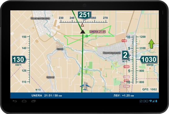
At Visual Prolog 7.4. made a test application and tried out the idea of a dynamic menu in the implementation of “one click to the necessary information”. Those. The application menu adjusts to the current state and flight mode and optimizes the menu so that the menu allows you to get the information you need at the moment. Unnecessary or irrelevant information, with such implementation is postponed. As you understand, this was done to reduce the pilot's access to relevant information in the minimum amount of time and necessary actions. The idea was also worked out to refine existing controls without interfering with the control loop or the technical part of the control systems, in order to simplify the work of the pilot (operator) with a dynamic menu and create feedback between the complex (software) and the pilot (operator). Samples on the created simulator showed that creating such a bundle is not only possible, but the cost price will be low. At the same time, additional equipment does not interfere with the existing control loop and in no way affects it.
We also worked out the panel, which produces the primary information of the pilot (operator) and reduces his attention to the assessment of current data. The display system was reduced to three channels of information supply, so that the pilot (operator) could perceive them as a whole. This area of work was separately worked out after analyzing information about the testing of aircraft take-off control devices (interrupted / continued take-off) and the observations and recommendations of test pilots who conducted the assessment of these devices. As you understand, the main claim of the testers to the device is an excess of information. We reduced the output of information to a minimum (three channels of information in one place, actually perceived as one channel).
If you make your own application or display system for drones, I highly recommend paying attention to the developments of companies such as rockwell collins and airbus . Colins - they have a very well developed cockpit ergonomics and amazing solutions in informing pilots. In Airbus - just amazing FMS (roughly speaking, autopilot or on-board computer), in which the input, calculated and output information is divided into different color groups, which allows the pilot to reduce the load when entering information. These systems are not reference, because They also have a number of drawbacks, but in these areas, especially in my opinion, the solutions are simple and of very high quality.
Well, besides this, they were working on a software reliability improvement system. They took as a basis the signs of correct operation of sensors and information sources, worked out algorithms that allow not only to determine the reliability of the data, but also the replacement of the compromised data with secondary data, with a relatively slight deterioration in the reliability. In tests, the failure of half of the sensors left the relevance of the software in the specified levels of safe flight.
For our own convenience, we made a small prototype, which we discussed with various pilots, and at this stage we received several orders for ready-made software.
Something like this ...
On this basis, I want to say that, taking into account the development of flying drones, the relevance of software and the entry of IT into the market of aviation equipment and information delivery systems is quite possible and in demand. Maybe someone will find their niche here.
If you have read this far, I want to say a few more words.
1. The purpose of the article is to tell about your dream. And maybe find like-minded people.
2. I do not pursue goals to earn karma or other preferences. It is more interesting for me to read Habr than to express my own, perhaps naive, judgments.
3. If my advice will allow someone to make their drone smarter - I will be glad.
4. It is a pity that in our country it is hard to realize your dreams.
Good luck to everyone and thank you!
PS: If someone is interested in my little article - I can make out an article about flying drones from the point of view of the pilot and especially flight errors, which could help make the flight safer and more predictable.
PPS: Thank you so much for such a good reception of the first article! I'll try to write another one.
The second point that I would like to voice is that, as it turned out, there are those who want to contact me, but have not found an opportunity. I apologize to you, the fact is that my profile has a link to my page in G +, and there is an opportunity to write me a letter. Part of exactly the same way. Those who did not work, here is my soap . Here I publish my contact especially to facilitate the method of communication for those who do not have a profile on Habré. If this causes criticism from the moderators or the community, please write the drug or comment, and remove the soap.
Thanks again for the support!
Source: https://habr.com/ru/post/237055/
All Articles