2GIS Floors. Ladder to the product
We love to explore the city and the characteristics of life in them. Detect the problems of city dwellers and propose solutions in 2GIS products. For example, in order for people to find companies faster, we prepared data on entries in a million companies in the country.
Solving one problem, we found another. Yes, now 2GIS leads users right to the door, but what if an organization or an ATM are inside a large building?

')
In fact, we threw a person with his problem, without showing exactly where the object of his search is located. It was necessary to urgently seek a solution.
So there was an idea that we called "Floors".
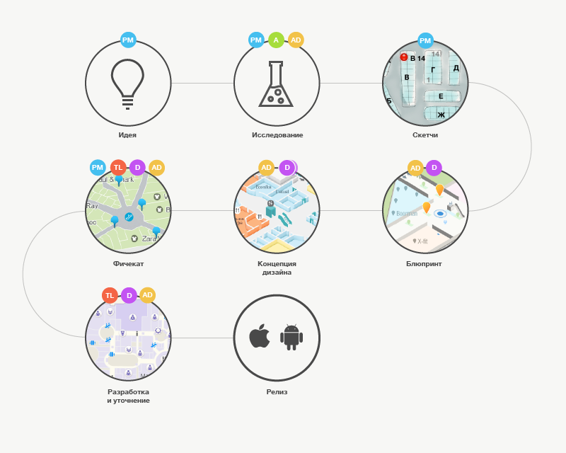
In addition to the history of the new opportunity in 2GIS, I would like to share our approach to its creation, talk about the participants and the features of the creation process. Therefore, familiarize yourself with the roles that will appear at each step of the product formulation.

And the process in general looked like this:

The issues of orientation in huge premises have been engaged for a long time and we wanted to understand the whole solution space, so the research led us to the 19th century.
In the 1840s and 1860s, the company of the French architect Leons Raynaud designed railway stations. And they were guided by the basic principle: to reduce the path of passengers from the entrance to the building to the train platform . Therefore, the basis of all projects lay: a large entrance, the viewed space of the train tracks, the grouping of institutions inside at the edges of the space. Thus, the main stations of France were designed: Austerlitz, Severny 1, Severny 2.
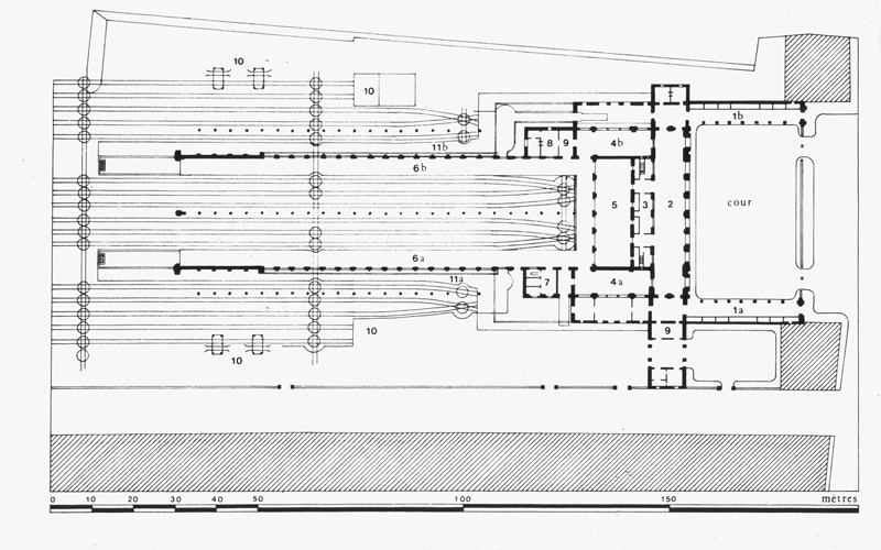
The approach was standardized, the architectural principles formed the basis of many stations and more than half a century solved the problems of internal navigation.
Similar was the Lert station in Berlin. It was destroyed during the Second World War and later exploded. Now in its place stands the Central Station of Berlin - the largest station in Europe, officially since 2006.
It takes several types of trains, is a shopping center and a major transportation hub. As you understand, only the architecture of the problem of navigation in such a room is no longer solved. For such large rooms, additional navigation systems are needed - signs, information boards, signs.
But at different times, in different buildings, cities, cultures there are differences in design languages, and this affects the differences between the internal navigation systems. Example - the transfer icon at different airports from the presentation of Sybil Schleich and Heike Neil.

And this is not so bad in general, if navigation icons are understandable, readable, recognizable in the context of the country and time. But today the situation is not uncommon when in the same building you will find several different navigation systems.
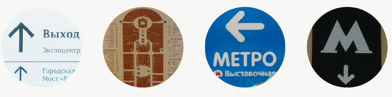
It turns out that you need a gate at the airport or you need to find a specific store in a shopping center, and on different floors, in different parts of the building there are different signs and you need to spend time from the tablet to the tablet: study them, understand whether you are moving in the right direction.
Convinced of the problem of internal navigation, we began to consider solutions for our products. Since we didn’t plan to master the architecture, but going the way of developing universal wayfinding sign systems for all institutions is an interesting, but not timely task. We took up the analysis of trends and the market for mobile solutions, and began to look towards the schemes and directories of huge buildings. We started with shopping centers and solving the navigation problems of customers.

It seemed that the well-developed concept of the card and interfaces would shorten the development time, so we enthusiastically began to design.
We in the design team needed support in finding a solution, a ringing metaphor that would help to design all the fundamental design elements. And we found it in the name of the new opportunity. So there were "Floors". This allowed us to begin to select references to the elements of the real world, various maps, to connect them with the features of maps and the 2GIS brand.
And in order to synchronize expectations and decide on a set of all design artifacts, they prepared a short blueprint. In which "Floors" we presented:
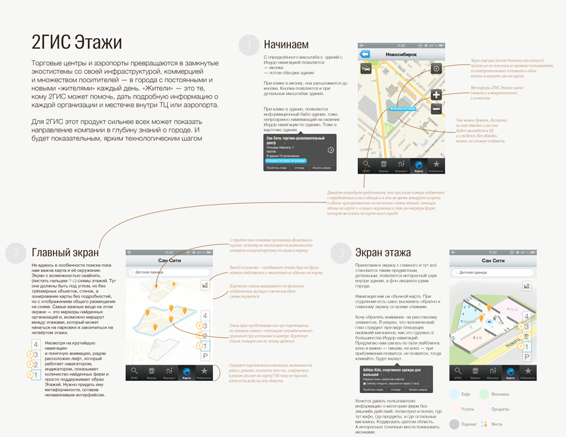

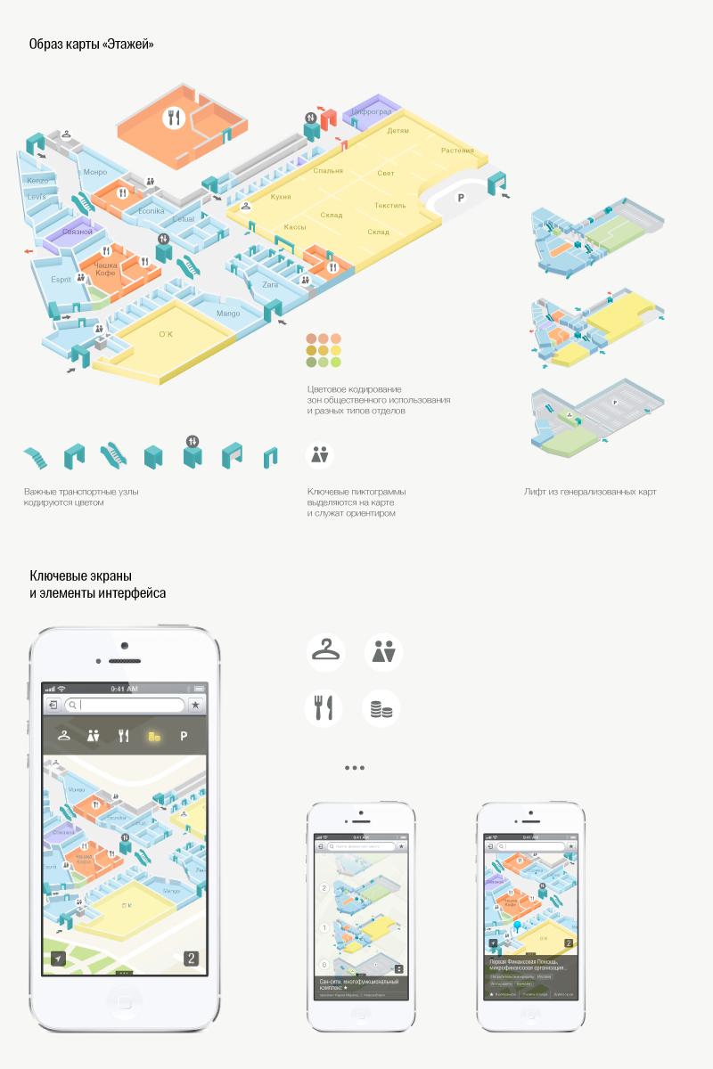
In the design of this mode, it was important for us to display the image of the 2GIS main map by expanding the floor plan with navigation elements. Here it was important to remember that inside the premises people are not guided by the principles of "north-south." As a rule, everyone is oriented towards the entrance to the building, and then they are checked with the largest, most visible and significant shops, points, elevators, escalators.

The design of the card, the interfaces and the concept of the new opportunity were well received in the company. Next was a series of internal presentations, clarification of layouts, a detailed study of the interface elements, the development of a dynamic prototype. After that, the task was decomposed and decomposed into sprints of different development and research teams.
So there were several main directions for study
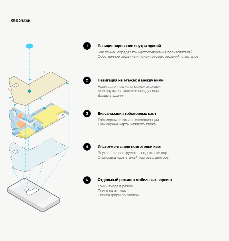
The research and development plan went far beyond the horizon. And with such a plan we did not release in the coming year. It was necessary to seek a compromise, the same MVP .

We created a timeframe for ourselves and looked at what can be put into this framework in order to solve the problem of users in the near future. We develop solutions in key areas.

So “Floors” go to a new step - feasibility within a reasonable time and the development, adjustment, preparation of data begins. Looking back at the elaboration of the “Floors” today, we understand that on the one hand, we went from idea to development very quickly, on the other hand, somewhat dreamily.
Now, while working on complex technological solutions, we try to connect technical specialists earlier or make small teams using features, we look soberly for the terms, but do not stop dreaming.
The release for iOS and Android versions came out in time with the six largest shopping centers in Moscow, which hid 2500+ organizations and 600+ infrastructure facilities.
We continue to prepare the largest shopping centers in the capital and other cities, and to develop the "Floors" functionally. Follow the news, "Floors" will appear in your city.
Solving one problem, we found another. Yes, now 2GIS leads users right to the door, but what if an organization or an ATM are inside a large building?
')
In fact, we threw a person with his problem, without showing exactly where the object of his search is located. It was necessary to urgently seek a solution.
So there was an idea that we called "Floors".
In addition to the history of the new opportunity in 2GIS, I would like to share our approach to its creation, talk about the participants and the features of the creation process. Therefore, familiarize yourself with the roles that will appear at each step of the product formulation.
And the process in general looked like this:
Analysis
The issues of orientation in huge premises have been engaged for a long time and we wanted to understand the whole solution space, so the research led us to the 19th century.
In the 1840s and 1860s, the company of the French architect Leons Raynaud designed railway stations. And they were guided by the basic principle: to reduce the path of passengers from the entrance to the building to the train platform . Therefore, the basis of all projects lay: a large entrance, the viewed space of the train tracks, the grouping of institutions inside at the edges of the space. Thus, the main stations of France were designed: Austerlitz, Severny 1, Severny 2.
The approach was standardized, the architectural principles formed the basis of many stations and more than half a century solved the problems of internal navigation.
Similar was the Lert station in Berlin. It was destroyed during the Second World War and later exploded. Now in its place stands the Central Station of Berlin - the largest station in Europe, officially since 2006.
It takes several types of trains, is a shopping center and a major transportation hub. As you understand, only the architecture of the problem of navigation in such a room is no longer solved. For such large rooms, additional navigation systems are needed - signs, information boards, signs.
But at different times, in different buildings, cities, cultures there are differences in design languages, and this affects the differences between the internal navigation systems. Example - the transfer icon at different airports from the presentation of Sybil Schleich and Heike Neil.
And this is not so bad in general, if navigation icons are understandable, readable, recognizable in the context of the country and time. But today the situation is not uncommon when in the same building you will find several different navigation systems.
It turns out that you need a gate at the airport or you need to find a specific store in a shopping center, and on different floors, in different parts of the building there are different signs and you need to spend time from the tablet to the tablet: study them, understand whether you are moving in the right direction.
Convinced of the problem of internal navigation, we began to consider solutions for our products. Since we didn’t plan to master the architecture, but going the way of developing universal wayfinding sign systems for all institutions is an interesting, but not timely task. We took up the analysis of trends and the market for mobile solutions, and began to look towards the schemes and directories of huge buildings. We started with shopping centers and solving the navigation problems of customers.
Finding a solution
It seemed that the well-developed concept of the card and interfaces would shorten the development time, so we enthusiastically began to design.
We in the design team needed support in finding a solution, a ringing metaphor that would help to design all the fundamental design elements. And we found it in the name of the new opportunity. So there were "Floors". This allowed us to begin to select references to the elements of the real world, various maps, to connect them with the features of maps and the 2GIS brand.
And in order to synchronize expectations and decide on a set of all design artifacts, they prepared a short blueprint. In which "Floors" we presented:
- as a separate mode of operation of the application, in which the user enters from the main map and can switch between shopping centers, view the list of floors of the shopping center, as in an elevator, by pressing buttons or with a swipe;
- for each department, store or shop you can get extended information;
- find the path to it and lead the user along this path.
Design
In the design of this mode, it was important for us to display the image of the 2GIS main map by expanding the floor plan with navigation elements. Here it was important to remember that inside the premises people are not guided by the principles of "north-south." As a rule, everyone is oriented towards the entrance to the building, and then they are checked with the largest, most visible and significant shops, points, elevators, escalators.
Getting to the development
The design of the card, the interfaces and the concept of the new opportunity were well received in the company. Next was a series of internal presentations, clarification of layouts, a detailed study of the interface elements, the development of a dynamic prototype. After that, the task was decomposed and decomposed into sprints of different development and research teams.
So there were several main directions for study
The research and development plan went far beyond the horizon. And with such a plan we did not release in the coming year. It was necessary to seek a compromise, the same MVP .
But not all at once
We created a timeframe for ourselves and looked at what can be put into this framework in order to solve the problem of users in the near future. We develop solutions in key areas.
So “Floors” go to a new step - feasibility within a reasonable time and the development, adjustment, preparation of data begins. Looking back at the elaboration of the “Floors” today, we understand that on the one hand, we went from idea to development very quickly, on the other hand, somewhat dreamily.
Now, while working on complex technological solutions, we try to connect technical specialists earlier or make small teams using features, we look soberly for the terms, but do not stop dreaming.
The release for iOS and Android versions came out in time with the six largest shopping centers in Moscow, which hid 2500+ organizations and 600+ infrastructure facilities.
We continue to prepare the largest shopping centers in the capital and other cities, and to develop the "Floors" functionally. Follow the news, "Floors" will appear in your city.
Source: https://habr.com/ru/post/224243/
All Articles