Japan creates a centimeter-resolution GPS alternative
 The Japanese company Mitsubishi Electric has announced its intention to launch a constellation of satellites into orbit, which after 2018 will provide high accuracy of the satellite. According to the authors of the idea, with increasing accuracy of coordinates, the possibilities of using satellite navigation in practical tasks are expanding. For example, robotic cars can accurately go through their lane, knowing the coordinates of the road markings.
The Quazi-Zenith Satellite System (QZSS) system is designed to complement the American GPS in Japan. QZSS satellites will allow you to calculate the location of the receiver with an accuracy of 1-3 centimeters.
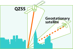
“GPS positioning can give an error of up to 10 meters due to various types of errors,” said Yuki Sato, engineer at the Advanced Technology R & D Center research and development department at Mitsubishi Electric. “And in Japan, the GPS signal is often blocked by mountains and skyscrapers, so in many places it is simply inaccessible.” Indeed, between skyscrapers in the center of Tokyo, it is almost impossible to catch him.
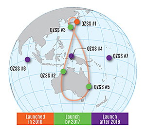
 Mitsubishi Electric is responsible for almost the entire "space" part of the project, including the manufacture of satellites. The Japan Aerospace Agency (JAXA) launched the first QZSS satellite in September 2010. Three more pieces will run until the end of 2017, and then the last three. This is enough to cover the entire country and its environs. From the point of view of the observer on earth, satellites in the sky will form a figure similar to the asymmetric figure "eight". At the same time, at least one satellite in geosynchronous orbit will always be in a quasi-zenith position, that is, with an elevation angle of more than 70 °. This is critically important for residents of big cities.
')
 The Japanese government has allocated $ 500 million for the first three satellites, as well as $ 1.2 billion for the construction of 1,200 reference stations on the ground.
The management of the ground stations is entrusted to a private company, Quazi-Zenith Satellite System Services, created specifically for this purpose.
Atomic clocks based on rubidium are installed on QZSS satellites. To eliminate inaccuracies during triangulation, the control station constantly monitors satellite readings and its real location relative to reference stations. Then the information is transmitted to the satellite for correction. According to the engineers, the system requires constant correction, so that the stream is transmitted to the satellite at a speed of 2 Kbit / s.
Tests of the first QZS-1 satellite showed that, after correction, it ensures positioning accuracy with an error of no more than 1.3 cm in the horizontal direction and 2.9 cm in the vertical. Such an accurate navigation system can be used, for example, for the automatic movement of vehicles and agricultural equipment.
Mitsubishi Electric emphasizes the low cost of QZSS compared to other satellite positioning systems. For example, the Galileo budget has already exceeded $ 6.9 billion.
Source: https://habr.com/ru/post/221059/
All Articles