Panoramas of the Arctic appeared on Yandex.Maps
Now on Yandex.Maps you can view the most northern territory of Russia - the archipelago of Franz Josef Land. For example, the giant glaciers or scenic mountains .
And my name is Olga Parshina, and I am an expert in shooting spherical panoramas of the company neq4 , partner of Yandex. In August 2013, I made a panorama of 11 islands of the archipelago as part of a scientific expedition for 42 days. In this post I want to tell you about what the summer Arctic looks like.
')
During the expedition to Franz Josef Land, I was among those few who were driven not by scientific interest, but by the desire to visit the most extreme north of Russia. The remaining participants represented the National Geographic Society of the United States, the Russian Arctic Park and the Russian Geographical Society. Each of them is an expert in his field: some studied microbes, others managed walrus, and others were responsible for archeology and geology. It is not the first time that a purely scientific society starts up in the Arctic, this time in the framework of the “Virgin Sea” project.
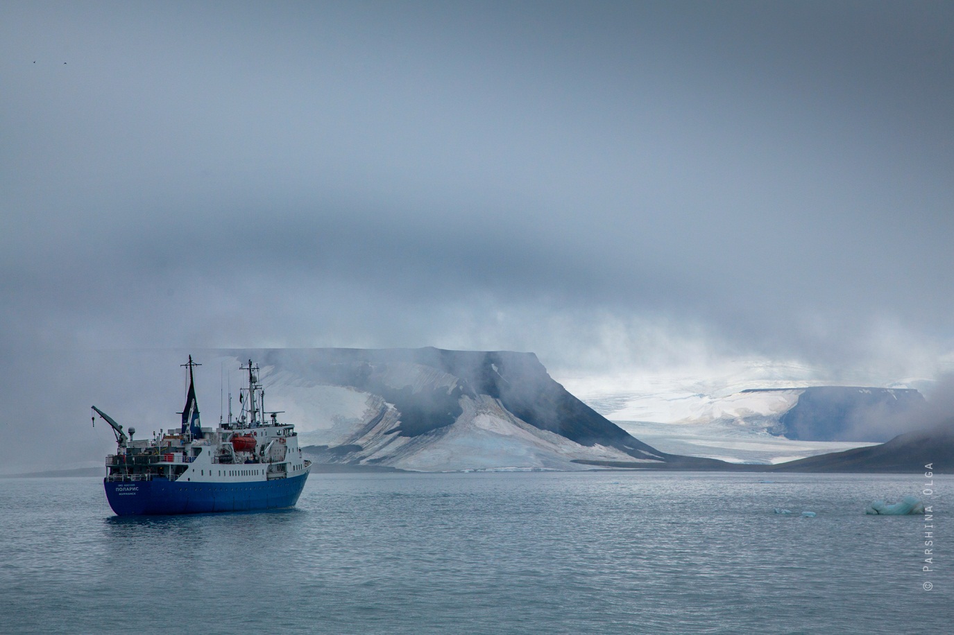
On July 26, 2013, Polaris , our cruise ship built specifically for sailing in Arctic waters, departed from Murmansk and headed for the nearest archipelago island, Alexandra Land.
The route of the expedition included several key points in which it was necessary to conduct research, but everything was decided on the spot - depending on the weather. It happened that we approached the island, but could not land because of the heavy wind, so we had to sail further.
During the expedition we lived on the ship. We woke up at eight, had breakfast, and then distributed into groups and set off to the ground. Finished work, as a rule, by dinner, other groups returned only late at night.
View panorama
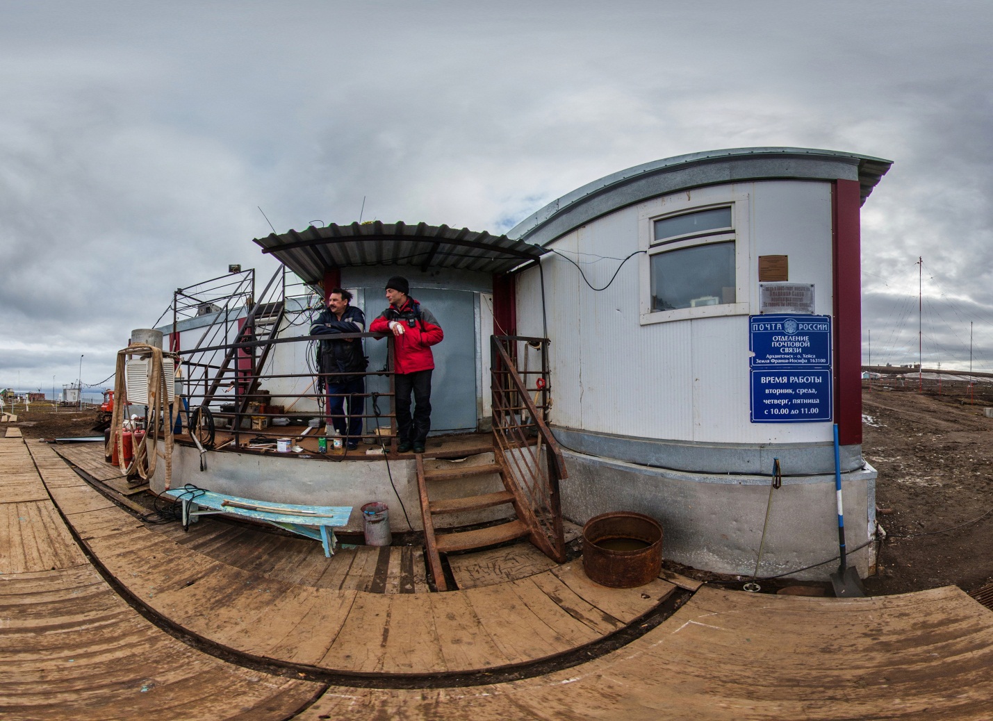
Heis Island is the northernmost post office in Russia. Nearby live three meteorologists. And this is almost the entire population of the archipelago, not counting the polar bears and employees of the only military unit "Nagurskaya" on Alexandra Land.
View panorama
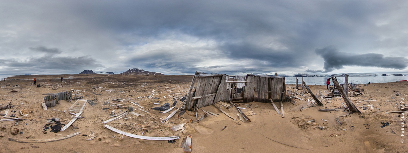
The first Soviet research station and the first Arctic Observatory under the guidance of the famous Arctic explorer Ivan Papanin were located on Huker Island in the area of the Silent Bay. Now on the island only empty houses. Some of them are almost a hundred years old.

View panorama
On Gowen Island, our geomorphologists found the site of the polar explorer Irwin Baldwin, who stormed the archipelago at the beginning of the 20th century. Although previously it was believed that his expedition had never visited this island. However, it was only possible to photograph his other parking lot - on Alger Island.
Animal bones are an indispensable part of the archipelago landscape. They are found everywhere. This is, for example, the skeleton of a polar bear.

View panorama
Polar bears are the largest predators of Franz Josef Land. Having no enemies in their natural habitat, they are practically afraid of nothing and try to stick their curious nose everywhere. To protect against attacks, each group was always accompanied by an armed guard. And although we almost never met bears, experienced researchers liked to repeat: “If you don’t see a polar bear, this doesn’t mean that it doesn’t exist”.

The second largest population of the archipelago, walruses, unfortunately did not fall on the panoramas. These are extremely shy animals, ready to go all the way with the haulout from the slightest rustle. Monopoly on their study went to zoologists, and they were extremely reluctant to meet any attempts to make at least a few pictures, not to mention letting me get the equipment and get up to its full height.
With its landscapes, Franz Josef Land is reminiscent of the landscapes of alien planets - columnar basalts stick out of the earth everywhere, and mountains with huge ice caps rise around the earth.
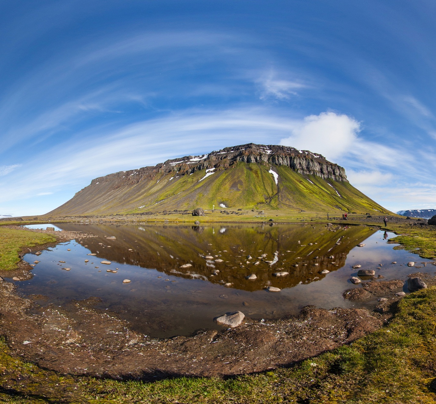
View panorama
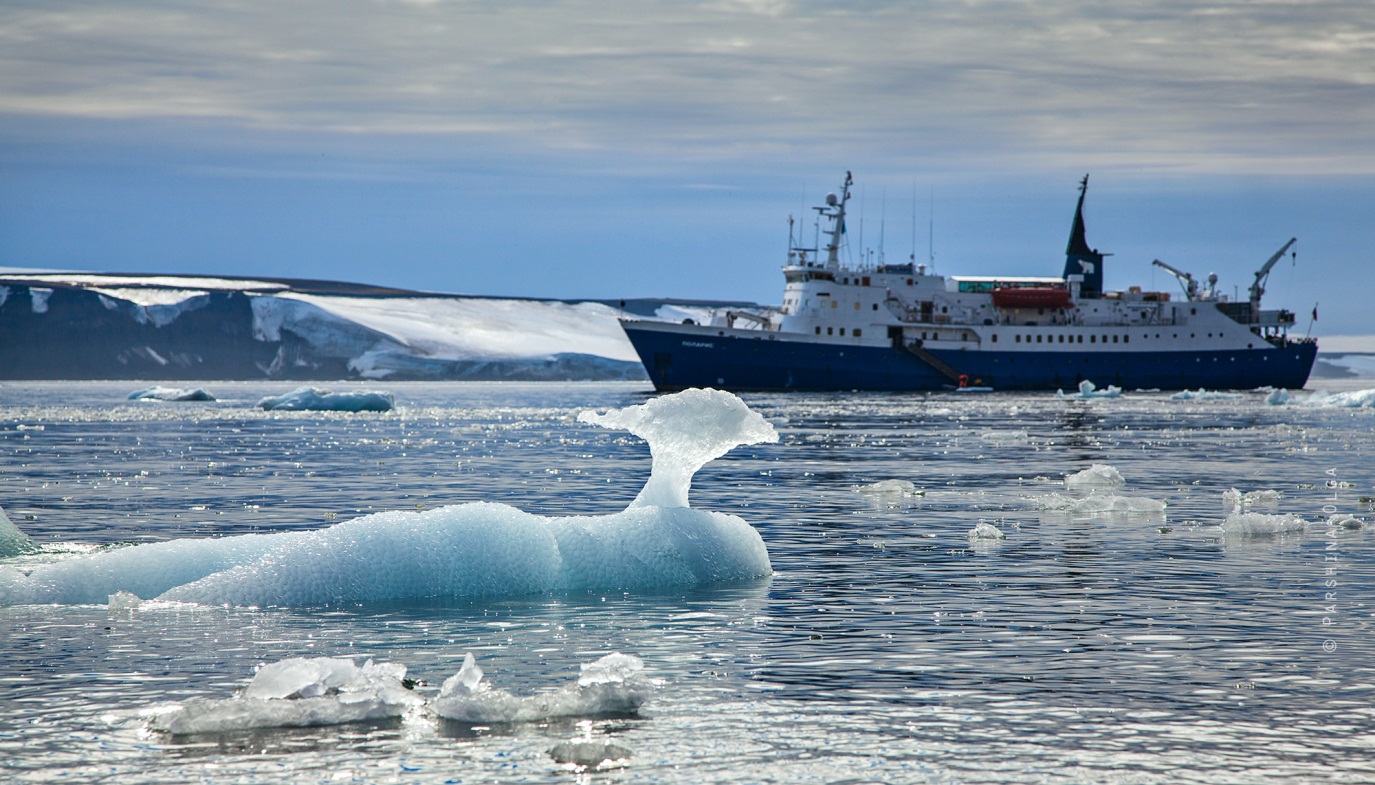
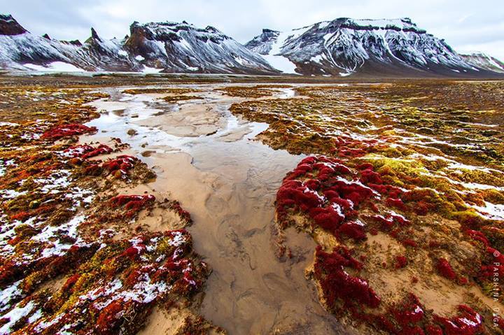
Here and there small streams flow - glaciers melt in the warm season. By the way, summer on the archipelago lasts nothing at all - a month, on the strength of two.
View panorama
The first shots for the panoramas were taken in early August - you can still see green grass on them. When we came back, in the same places there was almost nothing - the flowers and mosses quickly fade. Then everything draws ice and long winter begins.

The Arctic is often called the weather kitchen. You understand it, only being there. For some five minutes, the wind direction changes dramatically, low clouds appear from somewhere, flying at unimaginable speed, and it begins to snow. But most of the time we were lucky with the weather - the sun was shining, and the temperature was between zero and five degrees Celsius.

View panorama
In total, the expedition lasted 42 days. 42 days without communication with the outside world and in the conditions of nature so wild that the presence of a person in it seemed a deviation from the norm. It was the longest expedition to Franz Josef Land since the discoveries.
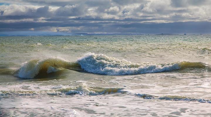
Towards the end, we did hit a storm that lasted all three days of our journey to Murmansk. The storm was so strong that the instruments and dishes were not kept on the tables, pictures were swaying on the walls, and the equipment constantly strove to tip over. Rare brave men who climbed onto the deck could observe gigantic waves. But for the Arctic, such weather is routine, and Polaris came out unscathed and not from such troubles.

View panorama
In total, during the expedition, I was able to shoot on 11 islands. It took 60 days and 4500 frames to prepare the material. The result was 255 panoramas. Now you can take a virtual walk where people are rare: to see the harsh islands and visit the abandoned buildings, whose walls remember the beginning of the last century.
And my name is Olga Parshina, and I am an expert in shooting spherical panoramas of the company neq4 , partner of Yandex. In August 2013, I made a panorama of 11 islands of the archipelago as part of a scientific expedition for 42 days. In this post I want to tell you about what the summer Arctic looks like.
')
During the expedition to Franz Josef Land, I was among those few who were driven not by scientific interest, but by the desire to visit the most extreme north of Russia. The remaining participants represented the National Geographic Society of the United States, the Russian Arctic Park and the Russian Geographical Society. Each of them is an expert in his field: some studied microbes, others managed walrus, and others were responsible for archeology and geology. It is not the first time that a purely scientific society starts up in the Arctic, this time in the framework of the “Virgin Sea” project.
On July 26, 2013, Polaris , our cruise ship built specifically for sailing in Arctic waters, departed from Murmansk and headed for the nearest archipelago island, Alexandra Land.
The route of the expedition included several key points in which it was necessary to conduct research, but everything was decided on the spot - depending on the weather. It happened that we approached the island, but could not land because of the heavy wind, so we had to sail further.
During the expedition we lived on the ship. We woke up at eight, had breakfast, and then distributed into groups and set off to the ground. Finished work, as a rule, by dinner, other groups returned only late at night.
View panorama
Heis Island is the northernmost post office in Russia. Nearby live three meteorologists. And this is almost the entire population of the archipelago, not counting the polar bears and employees of the only military unit "Nagurskaya" on Alexandra Land.
View panorama
The first Soviet research station and the first Arctic Observatory under the guidance of the famous Arctic explorer Ivan Papanin were located on Huker Island in the area of the Silent Bay. Now on the island only empty houses. Some of them are almost a hundred years old.
View panorama
On Gowen Island, our geomorphologists found the site of the polar explorer Irwin Baldwin, who stormed the archipelago at the beginning of the 20th century. Although previously it was believed that his expedition had never visited this island. However, it was only possible to photograph his other parking lot - on Alger Island.
Animal bones are an indispensable part of the archipelago landscape. They are found everywhere. This is, for example, the skeleton of a polar bear.
View panorama
Polar bears are the largest predators of Franz Josef Land. Having no enemies in their natural habitat, they are practically afraid of nothing and try to stick their curious nose everywhere. To protect against attacks, each group was always accompanied by an armed guard. And although we almost never met bears, experienced researchers liked to repeat: “If you don’t see a polar bear, this doesn’t mean that it doesn’t exist”.
The second largest population of the archipelago, walruses, unfortunately did not fall on the panoramas. These are extremely shy animals, ready to go all the way with the haulout from the slightest rustle. Monopoly on their study went to zoologists, and they were extremely reluctant to meet any attempts to make at least a few pictures, not to mention letting me get the equipment and get up to its full height.
With its landscapes, Franz Josef Land is reminiscent of the landscapes of alien planets - columnar basalts stick out of the earth everywhere, and mountains with huge ice caps rise around the earth.
View panorama
Here and there small streams flow - glaciers melt in the warm season. By the way, summer on the archipelago lasts nothing at all - a month, on the strength of two.
View panorama
The first shots for the panoramas were taken in early August - you can still see green grass on them. When we came back, in the same places there was almost nothing - the flowers and mosses quickly fade. Then everything draws ice and long winter begins.
The Arctic is often called the weather kitchen. You understand it, only being there. For some five minutes, the wind direction changes dramatically, low clouds appear from somewhere, flying at unimaginable speed, and it begins to snow. But most of the time we were lucky with the weather - the sun was shining, and the temperature was between zero and five degrees Celsius.
View panorama
In total, the expedition lasted 42 days. 42 days without communication with the outside world and in the conditions of nature so wild that the presence of a person in it seemed a deviation from the norm. It was the longest expedition to Franz Josef Land since the discoveries.
Towards the end, we did hit a storm that lasted all three days of our journey to Murmansk. The storm was so strong that the instruments and dishes were not kept on the tables, pictures were swaying on the walls, and the equipment constantly strove to tip over. Rare brave men who climbed onto the deck could observe gigantic waves. But for the Arctic, such weather is routine, and Polaris came out unscathed and not from such troubles.
View panorama
In total, during the expedition, I was able to shoot on 11 islands. It took 60 days and 4500 frames to prepare the material. The result was 255 panoramas. Now you can take a virtual walk where people are rare: to see the harsh islands and visit the abandoned buildings, whose walls remember the beginning of the last century.
Source: https://habr.com/ru/post/219823/
All Articles