Cityleeks.org
CityLeeks.org is an effective tool for influencing city residents on government officials, organizations and services who are responsible for maintaining order in a certain area, in a city, in an area.
We all face various socially significant problems around us (holes in the roads and courtyards, landfills, icicles on the roof of the house, selling cigarettes and alcohol to minors, etc.), i.e. such problems that worry not only us personally, but annoy many people. We want the organizations responsible for maintaining order in the respective territory to react to our appeals promptly, and the result of their work suits us.
The CityLeeks.org service allows any resident to report such problems, track their status and evaluate the work of the relevant services. Openness, publicity and drawing attention to the problem are the mechanisms that make responsible organizations act promptly and truly more responsibly.
')
Initially, this service was created as a clone of the well-known open Internet site “My territory” ( streetjournal.org ). Therefore, even part of the service description is very similar to their text.
But gradually, new ideas on the development of this service began to emerge, which I will discuss today. Some of them are already implemented, and some are still being prepared for release.
This feature allows you to view the area where the problem is located using webcams. Also at the moment of adding a problem, frames from webcams that reflect this problem are added to the problem photo album.
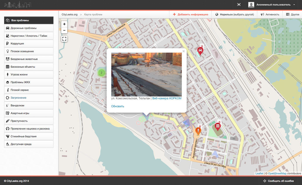
In addition, the map displays all areas that are covered by webcams. When you click on that, you can view frames from this webcam.
Over time, it became clear that all the information that users add to the map must be divided into two streams:
On the map, different types of information are displayed with labels with different colors:
In addition, each category of problems has its own icon. In addition, for the convenience of displaying a large number of icons, we use clustering.
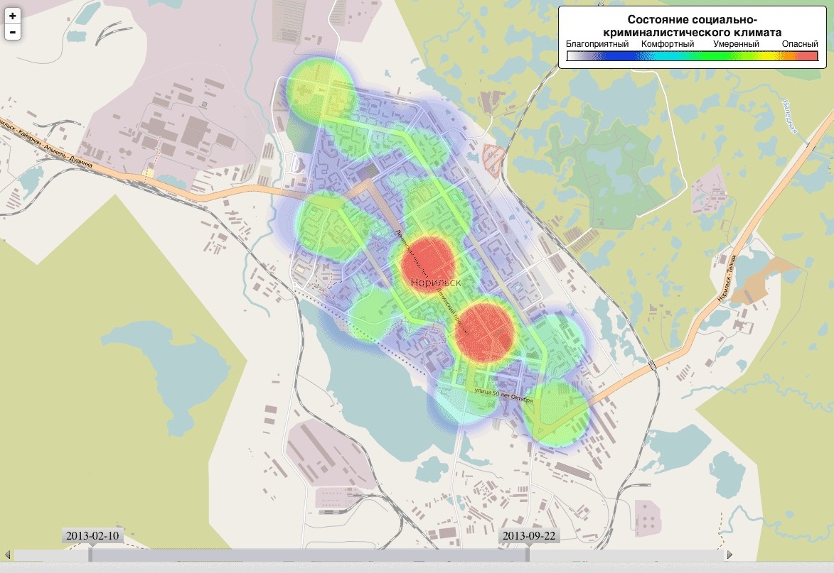
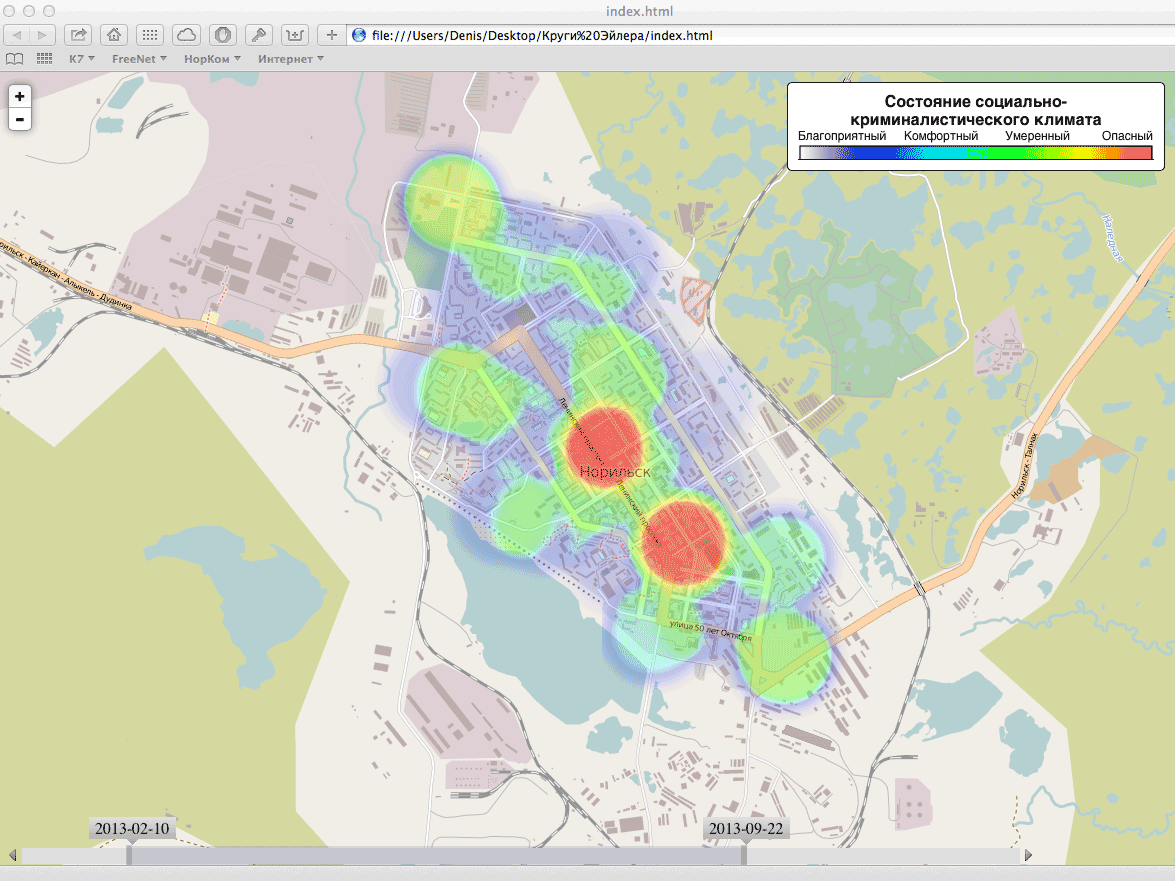
One of the key functions that will distinguish this service from the rest is the analysis and forecasting (!) Of the socio-forensic climate of the territory. This function will allow analyzing the incoming information (in addition to information coming from users, other sources are used) and based on these data, select the most unfavorable territories, as well as build a climate development forecast (“social wind”). We do this “quite interestingly”, therefore I will leave the description of this process for the following articles.
Soon the first mobile client will appear (under iOS). The application is already in development.
If you are willing to help the project and implement mobile clients for other operating systems, please contact us by mail . We will be glad to help.
The main purpose of this “article” is to understand whether it is worthwhile to engage in this project further and whether we are on the right path. Therefore, it will be very interesting to read the comments and opinions of the Habrahabr community.
PS You can fool around on the test server
We all face various socially significant problems around us (holes in the roads and courtyards, landfills, icicles on the roof of the house, selling cigarettes and alcohol to minors, etc.), i.e. such problems that worry not only us personally, but annoy many people. We want the organizations responsible for maintaining order in the respective territory to react to our appeals promptly, and the result of their work suits us.
The CityLeeks.org service allows any resident to report such problems, track their status and evaluate the work of the relevant services. Openness, publicity and drawing attention to the problem are the mechanisms that make responsible organizations act promptly and truly more responsibly.
')
This topic is written "read-only" by the user Robik and posted at his request. Therefore, answers to questions may appear with a long delay.
Initially, this service was created as a clone of the well-known open Internet site “My territory” ( streetjournal.org ). Therefore, even part of the service description is very similar to their text.
But gradually, new ideas on the development of this service began to emerge, which I will discuss today. Some of them are already implemented, and some are still being prepared for release.
Overview of the problem area
This feature allows you to view the area where the problem is located using webcams. Also at the moment of adding a problem, frames from webcams that reflect this problem are added to the problem photo album.
In addition, the map displays all areas that are covered by webcams. When you click on that, you can view frames from this webcam.
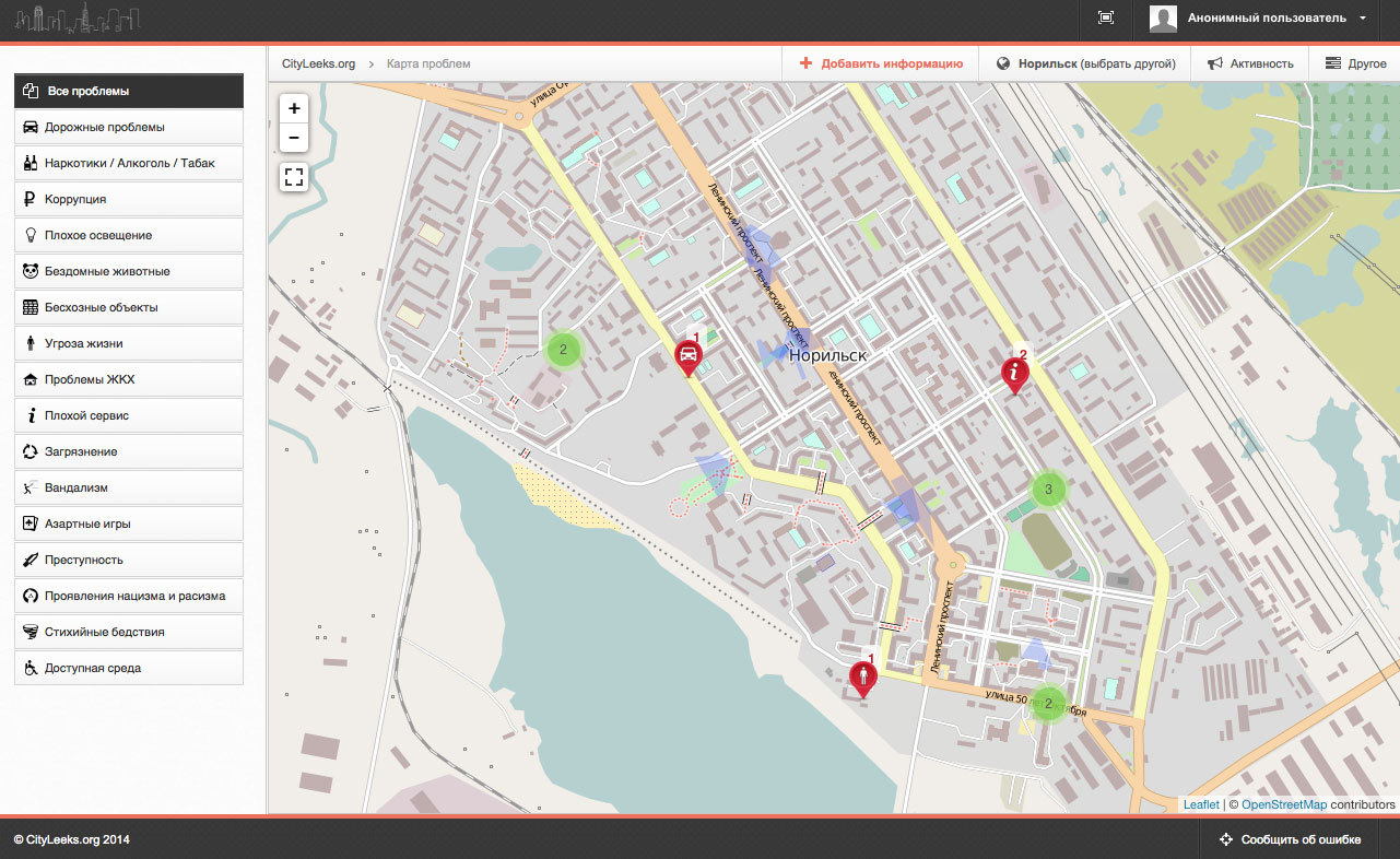
Alerts and Problems
Over time, it became clear that all the information that users add to the map must be divided into two streams:
- Notification - allows you to notify people or responsible organizations of any situation. For example, ice, traffic accidents or uncleaned snow. Alert displayed on the map specified time (default 3 hours);
- The problem is a “real” problem (garbage dump, pits on the road, etc.), which takes time to solve. The problem will be displayed on the map until its final decision.
On the map, different types of information are displayed with labels with different colors:
- Alert - orange label;
- Open issue - red label;
- Closed problem - green label.
In addition, each category of problems has its own icon. In addition, for the convenience of displaying a large number of icons, we use clustering.
Analysis and Forecasting
One of the key functions that will distinguish this service from the rest is the analysis and forecasting (!) Of the socio-forensic climate of the territory. This function will allow analyzing the incoming information (in addition to information coming from users, other sources are used) and based on these data, select the most unfavorable territories, as well as build a climate development forecast (“social wind”). We do this “quite interestingly”, therefore I will leave the description of this process for the following articles.
Mobile customers
Soon the first mobile client will appear (under iOS). The application is already in development.
If you are willing to help the project and implement mobile clients for other operating systems, please contact us by mail . We will be glad to help.
Conclusion
The main purpose of this “article” is to understand whether it is worthwhile to engage in this project further and whether we are on the right path. Therefore, it will be very interesting to read the comments and opinions of the Habrahabr community.
PS You can fool around on the test server
Source: https://habr.com/ru/post/218933/
All Articles