History of navigators
Once people were guided by the stars. Now everything is much simpler - it is enough to get the phone out of your pocket, enter the desired address into the Yandex card, and they will create a route. Or turn on the navigator in the car. Or look at the "smart watch" - a lot of ways. But did you know what the first navigators looked like? In the post - a brief history of navigators: from a mechanical wrist device to the projector in the helmet.
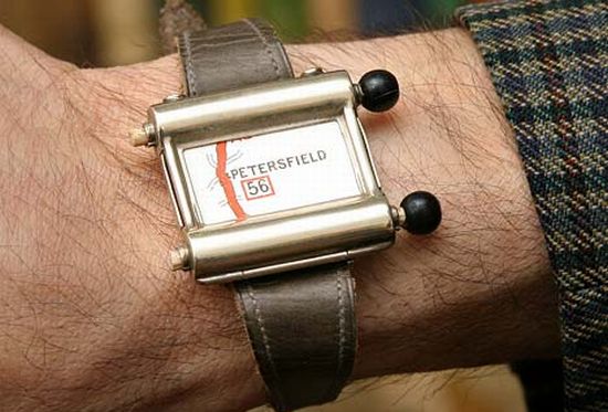
The first navigator appeared in the 1920s. Included with the Plus Fours Routefinder device, similar to a clock, were maps. Twist them needed manually.
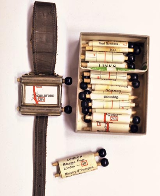
')
It was necessary to add this device to the History of smart watches . After all, it will be only 90 years, and the function of the navigator will perform a clock like the Pebble .
The next-generation navigator, Iter-Auto, appeared in 1930. Its main differences from the Plus Fours Routefinder consisted in the automatic scrolling of the map - while the speed with which the mechanism did this depended on the speed of the car. But it was necessary to turn off the road - as the driver had to get the maps, look for the right one, install it in the navigator and search for your current location.
Advertising Iter-Auto.

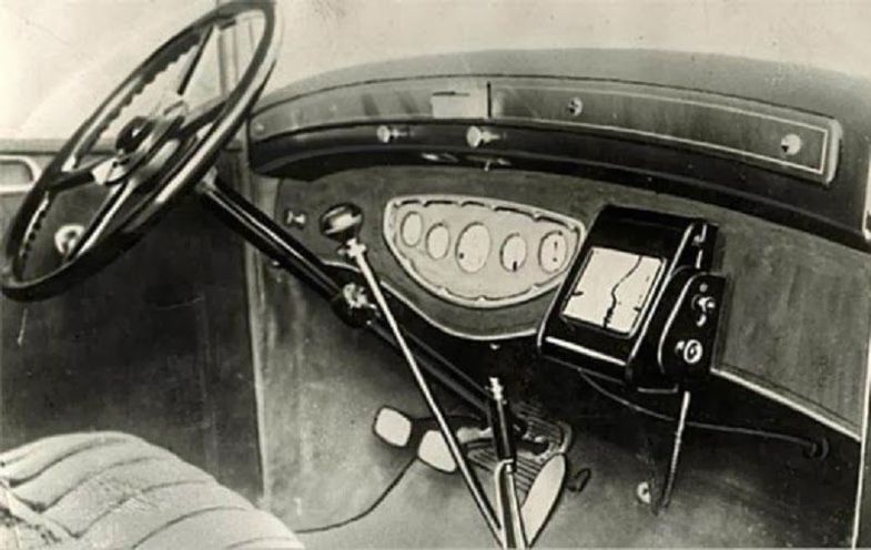
General Motors released Driver Aid Information and Routing in 1966. The system was designed to assist the driver and take on some of the functions of the driver, so that he could focus, in fact, on driving. Among the useful features - the ability to call on the radio telephone emergency or help desk. Press release dated February 1, 1967. Perforated maps were used as information carriers: the navigator was guided by them and reported on speed limits, direction and other important factors.

In 1957, the first artificial Earth satellite was sent into space in the Soviet Union. At the same time, American scientists observed a signal emanating from a satellite and found that, thanks to the Doppler effect, the frequency of the received signal increases as the satellite approaches and decreases with distance. Therefore, knowing your coordinates, you can find out the position and speed of the satellite, and, knowing the position of the satellite, you can determine your own speed and coordinates. Global satellite navigation technology: what are the systems, parameters and functions .
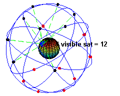
In 1974, the idea of satellite navigation was implemented, and the United States launched the first of 24 GPS satellites needed to cover the entire Earth. The last one launched in 1994. At the moment, these satellites are 32. As satellites are visible from one point:
This satellite was not launched, it is in a museum in San Diego.
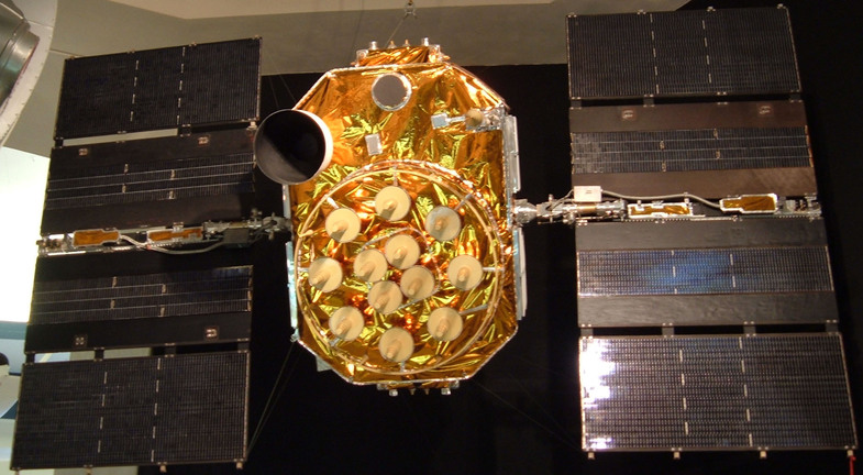
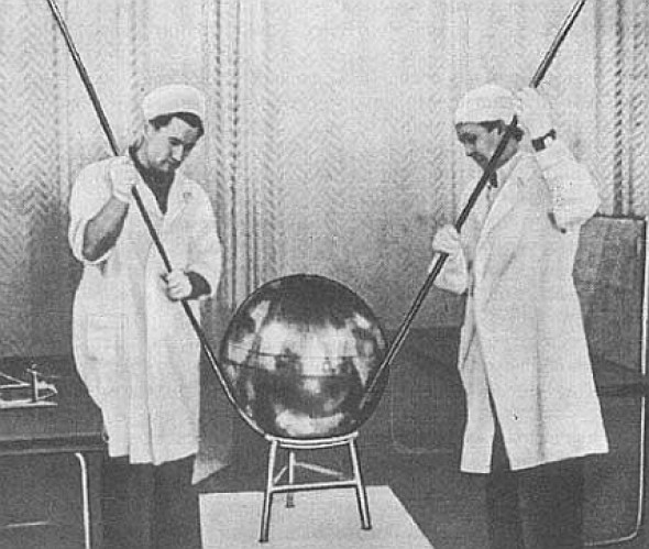
Officially, the GLONASS system began to be developed in the USSR in 1976, but it was not until 1984 that the first two satellites were launched. In the photo - the second generation GLONASS satellite. To fully cover the Earth, 24 satellites are also required.

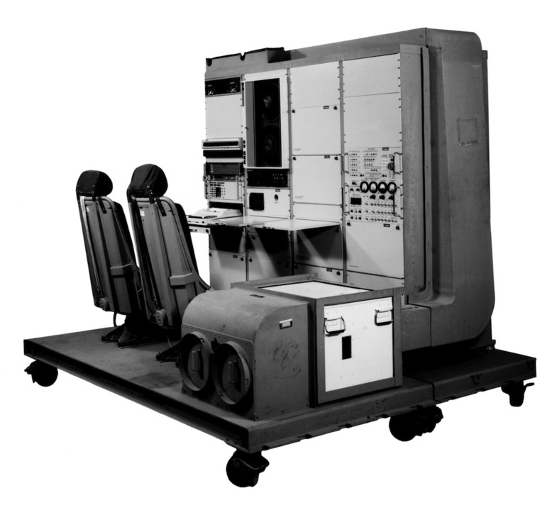
The first GPS receiver, designed for the US military, was a two-seater with wheels. Weighed about 122 kilograms. In 1983, the decision was made to create a civilian GPS system - after the Korean Airline aircraft flying over the USSR was shot down.
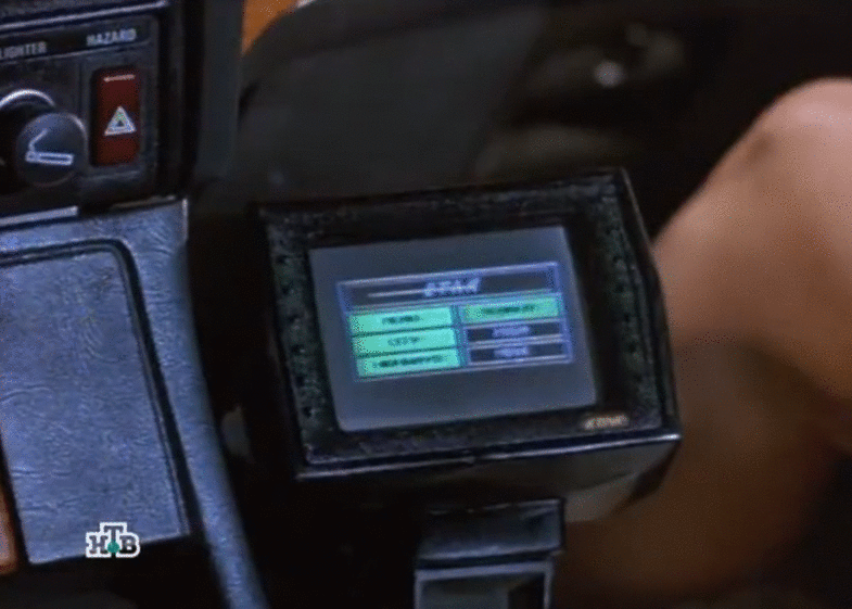
In 1985, the first mass navigator, The Etak Navigator, appeared in the USA. The image on the display - a nice green color. Of course, it was impossible to watch music and films on him, but he coped with his work. Cards for him were stored on tape.


In 1991, The Etak Navigator appeared in the film "Nothing But Trouble". In the frame - in fact, he and Demi Moore's leg.
Both GLONASS and GPS were originally developed for military purposes. The photo is part of the dashboard of a Black Hawk helicopter with a GPS navigator, early 1990s.

January or February 1991, Operation Desert Storm. GPS navigator installed in the Hummer.

The first receiver, designed to work with GLONASS and GPS simultaneously, was released in 1995 by Ashtech. It was not intended for the mass market.

Five years later, the first smartphone with GPS appears on the market - this is Benefon ESC. It was available to the mass consumer.


The first smartphone, equipped with a GLONASS receiver, went on sale in 2011 - the MTS 945.

At the moment, the role of the navigator can be performed not only by special gadgets, but by smartphones and various wearable devices - watches and glasses. For example, Google Glass allows the driver not to be distracted from the road.

Returning to the clock - the application for Pebble allows you to display tips on where to go next, right on your wristwatch. This is one of 10 applications for this gadget . They work in conjunction with an application running on a smartphone.

They often equip vehicles with factory navigators right at the factory - even Russian car manufacturers do it.

But much more interesting, of course, the devices purchased in addition. For example, the Garmin HUD navigator is equipped with a projector — the driver sees the direction of the next turn as an arrow on the windshield of the car. The device is synchronized with a smartphone on iOS or Android and uses the software running on it. And gets traffic jams from it via Bluetooth.

Motorcyclists also use navigators, which is associated with a number of inconveniences: while driving in a helmet, it is not very convenient to tilt your head to the navigator - this time, you have to stop to drive in the address - this is two. Therefore, among the wearable devices with navigation can be noted NUVIZ motorcycle helmet - it is needed in order to increase safety. The project has already received a sufficient amount of Kickstarter.


The software of the device will even allow to go around the bad weather, which is a significant bonus for two-wheeled vehicles.

In Russia, a similar project has been developed for five years now - this is LiveMap for bikers, a motorcycle helmet with a GPS navigator. Now you can make a pre-order on the site - for $ 1500, and when it becomes available - the price will be already 2000.
It is interesting:
Connected Volvo at MWC 2014
The history of smart watches
The history of personal computers in advertising. Part 3: 1990s
The first steps
The first navigator appeared in the 1920s. Included with the Plus Fours Routefinder device, similar to a clock, were maps. Twist them needed manually.
')
It was necessary to add this device to the History of smart watches . After all, it will be only 90 years, and the function of the navigator will perform a clock like the Pebble .
The next-generation navigator, Iter-Auto, appeared in 1930. Its main differences from the Plus Fours Routefinder consisted in the automatic scrolling of the map - while the speed with which the mechanism did this depended on the speed of the car. But it was necessary to turn off the road - as the driver had to get the maps, look for the right one, install it in the navigator and search for your current location.
Advertising Iter-Auto.
General Motors released Driver Aid Information and Routing in 1966. The system was designed to assist the driver and take on some of the functions of the driver, so that he could focus, in fact, on driving. Among the useful features - the ability to call on the radio telephone emergency or help desk. Press release dated February 1, 1967. Perforated maps were used as information carriers: the navigator was guided by them and reported on speed limits, direction and other important factors.
To space!
In 1957, the first artificial Earth satellite was sent into space in the Soviet Union. At the same time, American scientists observed a signal emanating from a satellite and found that, thanks to the Doppler effect, the frequency of the received signal increases as the satellite approaches and decreases with distance. Therefore, knowing your coordinates, you can find out the position and speed of the satellite, and, knowing the position of the satellite, you can determine your own speed and coordinates. Global satellite navigation technology: what are the systems, parameters and functions .
In 1974, the idea of satellite navigation was implemented, and the United States launched the first of 24 GPS satellites needed to cover the entire Earth. The last one launched in 1994. At the moment, these satellites are 32. As satellites are visible from one point:
This satellite was not launched, it is in a museum in San Diego.
Officially, the GLONASS system began to be developed in the USSR in 1976, but it was not until 1984 that the first two satellites were launched. In the photo - the second generation GLONASS satellite. To fully cover the Earth, 24 satellites are also required.
For military and civil
The first GPS receiver, designed for the US military, was a two-seater with wheels. Weighed about 122 kilograms. In 1983, the decision was made to create a civilian GPS system - after the Korean Airline aircraft flying over the USSR was shot down.
In 1985, the first mass navigator, The Etak Navigator, appeared in the USA. The image on the display - a nice green color. Of course, it was impossible to watch music and films on him, but he coped with his work. Cards for him were stored on tape.
In 1991, The Etak Navigator appeared in the film "Nothing But Trouble". In the frame - in fact, he and Demi Moore's leg.
Both GLONASS and GPS were originally developed for military purposes. The photo is part of the dashboard of a Black Hawk helicopter with a GPS navigator, early 1990s.
January or February 1991, Operation Desert Storm. GPS navigator installed in the Hummer.
The first receiver, designed to work with GLONASS and GPS simultaneously, was released in 1995 by Ashtech. It was not intended for the mass market.
Five years later, the first smartphone with GPS appears on the market - this is Benefon ESC. It was available to the mass consumer.
The first smartphone, equipped with a GLONASS receiver, went on sale in 2011 - the MTS 945.
Today
At the moment, the role of the navigator can be performed not only by special gadgets, but by smartphones and various wearable devices - watches and glasses. For example, Google Glass allows the driver not to be distracted from the road.
Returning to the clock - the application for Pebble allows you to display tips on where to go next, right on your wristwatch. This is one of 10 applications for this gadget . They work in conjunction with an application running on a smartphone.
They often equip vehicles with factory navigators right at the factory - even Russian car manufacturers do it.
But much more interesting, of course, the devices purchased in addition. For example, the Garmin HUD navigator is equipped with a projector — the driver sees the direction of the next turn as an arrow on the windshield of the car. The device is synchronized with a smartphone on iOS or Android and uses the software running on it. And gets traffic jams from it via Bluetooth.
Motorcyclists also use navigators, which is associated with a number of inconveniences: while driving in a helmet, it is not very convenient to tilt your head to the navigator - this time, you have to stop to drive in the address - this is two. Therefore, among the wearable devices with navigation can be noted NUVIZ motorcycle helmet - it is needed in order to increase safety. The project has already received a sufficient amount of Kickstarter.
The software of the device will even allow to go around the bad weather, which is a significant bonus for two-wheeled vehicles.
In Russia, a similar project has been developed for five years now - this is LiveMap for bikers, a motorcycle helmet with a GPS navigator. Now you can make a pre-order on the site - for $ 1500, and when it becomes available - the price will be already 2000.
It is interesting:
Connected Volvo at MWC 2014
The history of smart watches
The history of personal computers in advertising. Part 3: 1990s
Source: https://habr.com/ru/post/214333/
All Articles