Global satellite navigation technology: what are the systems, parameters and functions
In this article we will tell about global positioning systems developed in the USA, Russia, the EU and China; We will explain how global satellite navigation technology support is implemented in electronic devices, as well as describe the key and additional functions of modern navigation receivers.
GPS

The GPS (Global Positioning System) system was created for military use. She began to work in the late 80s - early 90s, but until 2000, artificial restrictions on the determination of the location significantly restrained her ability to use for civilian purposes.
')
After the cancellation of restrictions on the accuracy of determining the coordinates, the error decreased from 100 to 20 m (in the latest generations of GPS receivers, under ideal conditions, the error does not exceed 2 m). Such conditions allowed to use the system for a wide range of general and special tasks:
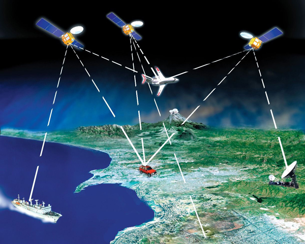
- Determination of exact location
- Navigation, route route linked to a map based on real location
- Time synchronization
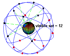
Orbits of GPS satellites. An example of the visibility of satellites from one of the points on the surface of the Earth. Visible sat is the number of satellites visible above the observer’s horizon under ideal conditions (clean field).
GLONASS

The Russian analogue of GPS - GLONASS (global navigation satellite system) - was deployed in 1995, but due to the lack of funding and a short satellite service life, it was not widely used. The second birth of the system can be considered the year 2001, when the target program for its development was adopted, thanks to which GLONASS resumed full-fledged work in 2010.
Today, 24 GLONASS satellites are in orbit, they cover the entire globe with a navigation signal.
The newest consumer devices use GPS and GLONASS as complementary systems, connecting to the nearest satellites found, this significantly increases the speed and accuracy of their work.
Example: a car GPS / GLONASS navigation and communication device based on Android OS, developed by Promwad team for the Russian design bureau. Implemented GSM / GPRS / 3G support. The device automatically updates the traffic information in real time and offers the driver the best route, taking into account the traffic congestion.
Two more satellite systems are currently under development: the European Galileo and the Chinese Compass.
Galileo

Galileo is a joint project of the European Union and the European Space Agency, announced in 2002. Initially, it was hoped that as early as 2010, within the framework of this system, 30 satellites would work in medium-Earth orbit. But this plan was not implemented. Now, 2014 is considered the estimated starting date for Galileo. However, it is expected that full-featured use of the system will begin no earlier than 2020.
Compass

This is the next stage of development of the Chinese regional navigation system Beidou, which was put into operation after the launch of 10 satellites at the end of 2011. It now provides coverage within the boundaries of Asia and the Pacific, but is expected to become global by 2020.
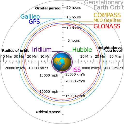
Comparison of the orbits of satellite navigation systems GPS, GLONASS, Galileo and Compass (Middle Earth Orbit - MEO) with the orbits of the International Space Station (ISS), the Hubble telescope and a series of Iridium satellites in the low orbit, as well as the geostationary orbit and the nominal size of the Earth.
GNSS support
The support of global navigation satellite systems (GNSS) technologists in electronic devices is implemented on the basis of navigation receivers, which can be implemented in various versions:
- Smart Antenna - a module consisting of a ceramic antenna and navigation receiver. Advantages: compactness, does not require coordination, reduces the cost of development by reducing the time.
- MCM (Multi Chip Module) - a chip that includes all the components of the navigation receiver.
- OEM is a shielded board that includes an RF interface processor and a baseband frequency processor (RF-frontend + baseband), SAW filters, and a harness. This is the most popular solution at the moment.
The navigation module is connected to the microcontroller or system on a chip via the UART / RS-232 or USB interface.
Key parameters of navigation receivers
Before the navigation receiver can provide location information, it must have three data sets:
- Satellite signals
- Almanac - information on the approximate parameters of the orbits of all satellites, as well as data for the calibration of clocks and characteristics of the ionosphere
- Ephemeris - exact parameters of the orbits and hours of each satellite
The TTFF characteristic shows how long a receiver takes to search for signals from satellites and positioning. If the receiver is new, or has been turned off for a long period, or has been transported a long distance from the moment it was last turned on, the time to receive the necessary data and determine the location increases.
Receiver manufacturers use various methods to reduce TTFF, including downloading and saving almanac and ephemeris over wireless data networks (also known as Assisted GPS or A-GPS), this is faster than extracting this data from GNSS signals.
A cold start describes a situation where the receiver needs to receive all the information to determine the location. This can take up to 12 minutes.
A warm start describes a situation where the receiver has almost all the necessary information in memory, and it will determine the place in a minute.
One of the key parameters of navigation modules in mobile devices is power consumption. Depending on the mode of operation, the module consumes different amounts of energy. The search phase of the satellite (TTFF) is characterized by a large, and tracking a lower power consumption. Also, manufacturers implement various schemes to reduce energy consumption, for example, by periodically switching the module to sleep.
As a rule, all modules issue data using the NMEA-0183 text protocol, but in addition to the specified text protocol, each manufacturer has its own binary protocol (Binary), which allows you to change the module configuration for a specific use or access additional functionality, as well as access to raw measurements. The binary protocol is convenient for use on microcontrollers, since there is no need to perform conversion from text to binary data, thereby saving program memory by eliminating the library of working with strings and time for conversion.
The NMEA-2000 standard is an evolution of the NMEA-0183 protocol. The NMEA-2000 uses a CAN bus as the physical layer, which was chosen to be more secure than RS-232. From the point of view of the data transfer protocol, the NMEA-2000 differs significantly from its predecessor, since uses a binary protocol based on the SAE J1939 standard.
The frequency of updating the location and speed of all modules is 1 Hz, but if necessary it can be raised to 5 or 10 Hz.
Depending on the application, the module can be configured for certain dynamic characteristics that it should monitor (for example, the maximum acceleration of the object). This allows you to use the optimal algorithm and improve the quality of measurements.
To perform the navigation task, the module must simultaneously receive signals from several satellites, i.e. have multiple receiving channels . To date, this number is in the range from 12 to 88.
GPS positioning accuracy is on average 15 m, it is due to the inaccurate signal used, the effect of the atmosphere on radio signal propagation, the quality of quartz oscillators in receivers, etc. But with the help of corrective methods, it is possible to improve the position accuracy. This technology is called Differential GPS . There are two methods of correction: terrestrial and satellite DGPS.
In terrestrial correction methods, terrestrial stations of differential corrections constantly verify their known location and signals from navigation satellites. On the basis of this information, correction values are calculated, which can be transmitted using a VHF or DV transmitter to mobile DGPS receivers in the RTCM format. Based on the information received, the consumer can adjust the process of determining their own location. The accuracy of this method is 1-3 meters and depends on the distance to the transmitter of the correction information and the quality of the signal.
Satellite methods, such as the Wide Area Augmentation System ( WAAS ) available in North America and the European Geostationary Navigation Overlay System ( EGNOS ) available in Europe, send corrective data from geostationary satellites, thus achieving a larger reception area, than with ground methods.
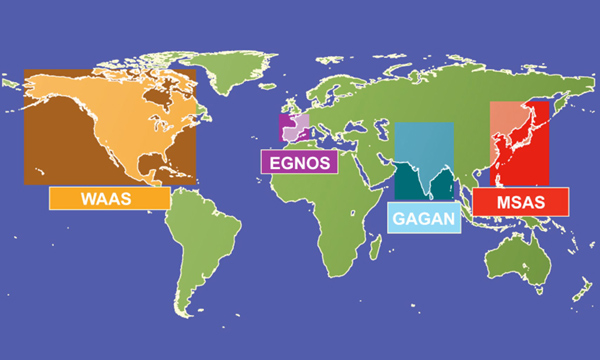
Satellite based differential correction systems (SBAS - Space Based Augmentation Systems) can improve the accuracy, reliability and availability of the navigation system by integrating external data in the calculation process
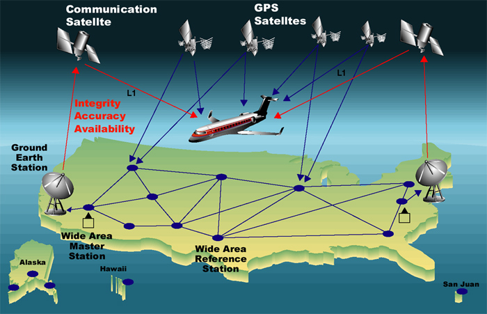
Demonstration of the principle of the WAAS (Wide Area Augmentation System) in the United States
One of the main parameters affecting the accuracy of location and reception stability is sensitivity . It is usually determined by the quality of the low-noise amplifier at the input of the receiver and the complexity of the implemented digital processing algorithms. Typical values of modern receivers are in the range of 143 dBm for searching and 160 dBm for tracking.
In addition to determining the location of the GNSS provide information about the exact time. As a rule, all receivers have a PPS output (pulse per second, pulses per second) - a second mark (1 Hz), which is precisely synchronized with the UTC time scale.
Additional features of navigation devices
The number of the way . On the basis of information about the direction of movement and the distance traveled (provided by additional sensors), the receiver can calculate its coordinates in the absence of signals from satellites (for example, in tunnels, in underground stations and in dense urban development).
Some modules have the ability to directly connect flash memory (for example, by SPI) to the module for recording a track with the required frequency. This feature eliminates the need for a separate microcontroller, or it may be useful to minimize power consumption (i.e., the system on the chip may be in a state of sleep).
This completes a superficial overview of global satellite navigation technologies. Thanks for attention. Examples of implemented projects based on these GLONASS and GPS can be found on the Promwad company's development page.
Source: https://habr.com/ru/post/202722/
All Articles